
While GFS may be overhyping the trailing system, it's not entirely a CAG phantom either. We'll see what happens in 30 hours.
Moderator: S2k Moderators


cheezyWXguy wrote:skyline385 wrote:cheezyWXguy wrote:You’re right, it’s not 91L that the gfs spins up into a major, but that area doesn’t originate from the cag. Watch the 850mb vorticity and you’ll see that some trailing vorticity splits off after it passes the lesser Antilles. GEFS shows something similar, with members starting to pop up in the east-central Caribbean. Icon shows a hint of this too. There could be something to this, but we need more continuity.
Another note, just because the gfs has a notorious cag bias doesn’t mean it will always be wrong when it shows it. Climatologically, we are getting to the time of year where a cag scenario is actually plausible. Again, not the scenario the gfs is showing at the moment, but even if it were a broken clock is still right twice a day.
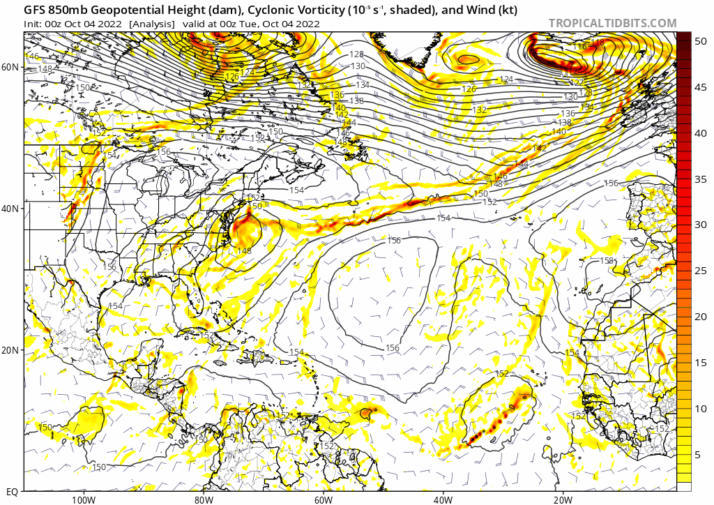
ICON's genesis is from the actual 91L, GFS builds up spurious vorticity from SA and builds the second system. The 850mb vorticity plot also looks like a classic GFS certified solution with two systems extremely close to each other.
https://i.imgur.com/0FQoqT0.png
https://twitter.com/AndyHazelton/status/1577061136708403200?s=20&t=bhoXSc2KPjnUrHLXCuJjhw
Again, it could be spurious (hence “need more continuity” but it’s not from SA or the CAG.
ICON does develop 91L but shows a hint of the trailing system too, though it’s harder to tell if it comes off of SA when only looking at 500mb


skyline385 wrote:cheezyWXguy wrote:skyline385 wrote:
ICON's genesis is from the actual 91L, GFS builds up spurious vorticity from SA and builds the second system. The 850mb vorticity plot also looks like a classic GFS certified solution with two systems extremely close to each other.
https://i.imgur.com/0FQoqT0.png
https://twitter.com/AndyHazelton/status/1577061136708403200?s=20&t=bhoXSc2KPjnUrHLXCuJjhw
Again, it could be spurious (hence “need more continuity” but it’s not from SA or the CAG.
[url]https://i.ibb.co/YkPTRvK/5-F8-CDC22-DA76-4-FD8-8739-2-CE45-E93-B083.jpg [/url]
ICON does develop 91L but shows a hint of the trailing system too, though it’s harder to tell if it comes off of SA when only looking at 500mb
[url]https://i.ibb.co/64YY12f/78716954-F67-C-4-DCB-B39-A-20784-E947467.jpg [/url]
TT’s colors makes it hard to see but here is the trailing vorticity being amplified by spurious vorticity over SA.
https://uploads.tapatalk-cdn.com/20221004/9839026d3d35c22d508c52d8e1495fbb.jpg
Also regarding the ICON, that plot is Z500 which would basically be the MLC. You can get a weak MLC going very easily but that doesn’t translate to a low level circulation. Here’s the actual Z850 on the ICON, no trailing vorticity here.
https://uploads.tapatalk-cdn.com/20221004/153f649d7056af7dc1ab7a40133de1ed.jpg


REDHurricane wrote:skyline385 wrote:cheezyWXguy wrote:
Again, it could be spurious (hence “need more continuity” but it’s not from SA or the CAG.
[url]https://i.ibb.co/YkPTRvK/5-F8-CDC22-DA76-4-FD8-8739-2-CE45-E93-B083.jpg [/url]
ICON does develop 91L but shows a hint of the trailing system too, though it’s harder to tell if it comes off of SA when only looking at 500mb
[url]https://i.ibb.co/64YY12f/78716954-F67-C-4-DCB-B39-A-20784-E947467.jpg [/url]
TT’s colors makes it hard to see but here is the trailing vorticity being amplified by spurious vorticity over SA.
https://uploads.tapatalk-cdn.com/20221004/9839026d3d35c22d508c52d8e1495fbb.jpg
Also regarding the ICON, that plot is Z500 which would basically be the MLC. You can get a weak MLC going very easily but that doesn’t translate to a low level circulation. Here’s the actual Z850 on the ICON, no trailing vorticity here.
https://uploads.tapatalk-cdn.com/20221004/153f649d7056af7dc1ab7a40133de1ed.jpg
Agreed, even if there may be some sort of MLC or other energy trailing behind the main part, there's no way it is going to instantaneously amplify like that unless you're in GFS fantasy wonderland. My approximated GFS CAG bias zone for this season reaches just far enough east that it encompasses the tiny trailing piece of energy right as it transforms into another specialty GFS phantom hurricane. I'm far from an expert on this so take my opinion with a sizable grain of salt as always, but everything I do know tells me that it just don't work like that
https://i.ibb.co/L8hXr0Z/gfs-z850-vort-atl-27.png


cycloneye wrote:06z GFS is much more bullish. This is not another piece of energy from South America, is from 91L.
https://i.imgur.com/KD04o4r.gif


Iceresistance wrote:cycloneye wrote:06z GFS is much more bullish. This is not another piece of energy from South America, is from 91L.
https://i.imgur.com/KD04o4r.gif
If I'm correct, 91L will become another Caribbean monster if it manages to survive the ULL shear into the Caribbean?
EDIT: Just saw the run, it's a Belize Blitzer.

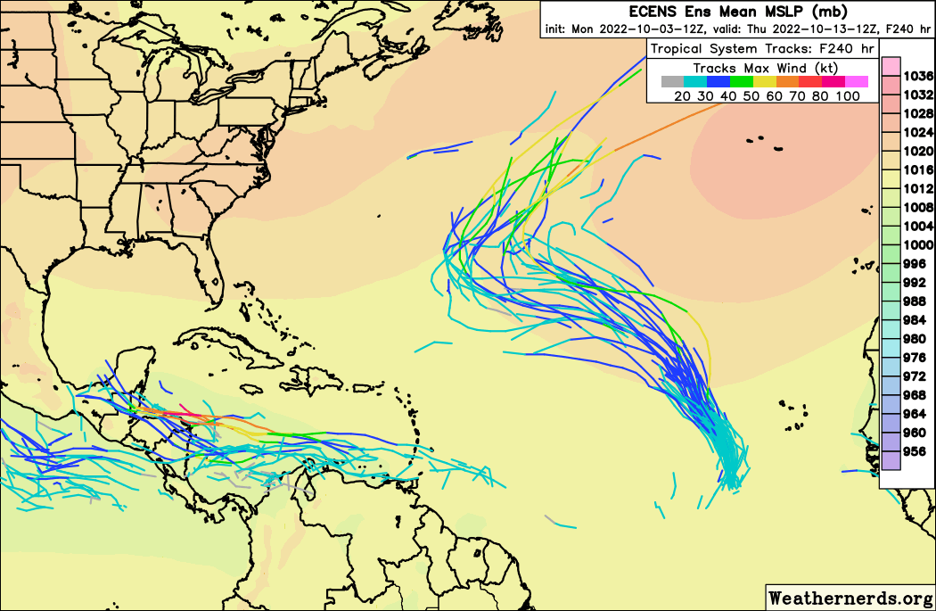
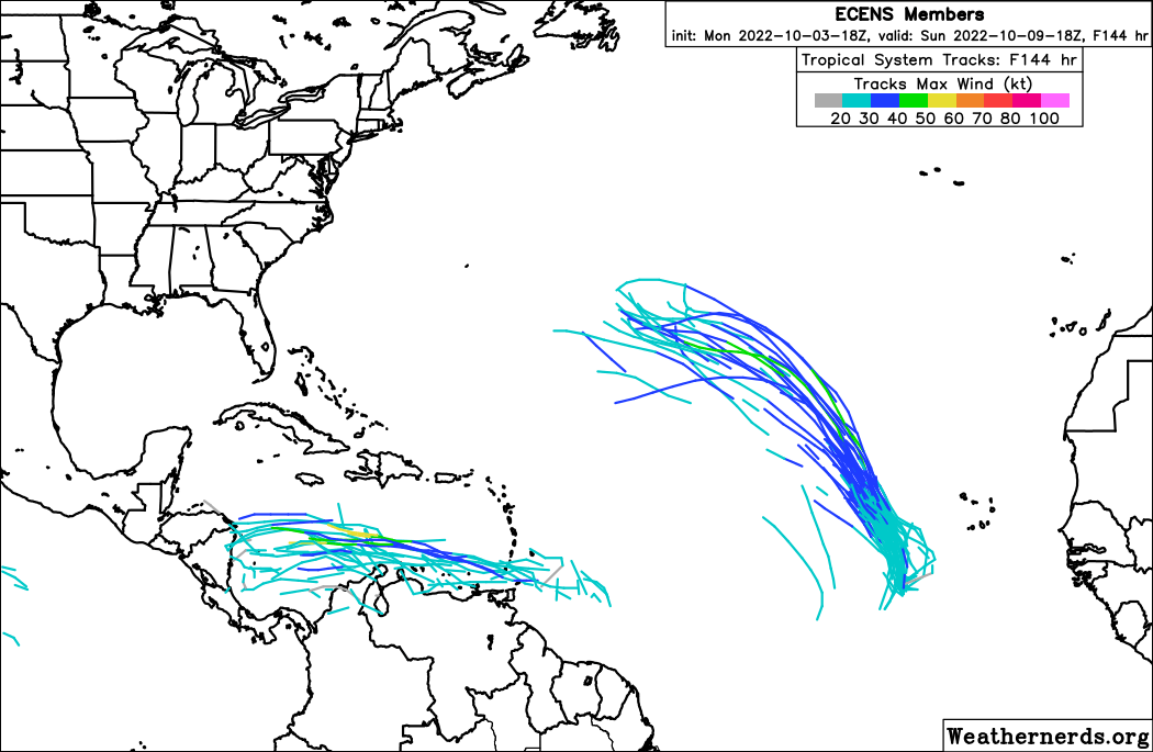
Teban54 wrote:Somewhat good support on the 12z and 18z Euro ensembles:
https://i.postimg.cc/Dz7H7JqB/ecens-2022-10-03-12-Z-240-50-258-0-350-MSLP-Surface-tracks.png
https://i.postimg.cc/QNRXhmVm/ecens-2022-10-03-18-Z-144-50-258-0-350-MSLP-Surface-tracks.png


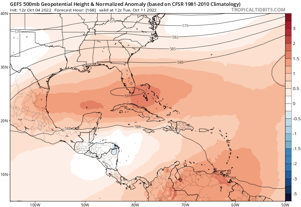

SouthFLTropics wrote:Based on everything we are seeing I think that 91L is a shoe in for a Central America strike. With regard to any potential CONUS impacts, I think we will need to watch future model runs to see what the remnants do after and/or if it emerges back into the Bay of Campeche. The setup seems to be very much like Mitch 1998. Mitch did eventually emerge in the BOC and reform into a tropical storm before scooting ENE and crossing Florida. At least for the next 10 days, I think the GOM and Florida are closed for business. High pressure in control and beautiful weather here in South Florida today. Forecast looks good into next week.

SFLcane wrote:SouthFLTropics wrote:Based on everything we are seeing I think that 91L is a shoe in for a Central America strike. With regard to any potential CONUS impacts, I think we will need to watch future model runs to see what the remnants do after and/or if it emerges back into the Bay of Campeche. The setup seems to be very much like Mitch 1998. Mitch did eventually emerge in the BOC and reform into a tropical storm before scooting ENE and crossing Florida. At least for the next 10 days, I think the GOM and Florida are closed for business. High pressure in control and beautiful weather here in South Florida today. Forecast looks good into next week.
ST jet fully entrenched seems likely the Conus season is just about over.
https://i.postimg.cc/xdQQfLb3/gfs.png
Users browsing this forum: No registered users and 20 guests


