ATL: KARL - Post Tropical - Discussion
Moderator: S2k Moderators
-
tropicwatch

- Category 5

- Posts: 3205
- Age: 60
- Joined: Sat Jun 02, 2007 10:01 am
- Location: Panama City Florida
- Contact:
Re: ATL: KARL - Tropical Storm - Discussion
The fight between high pressures.
1 likes
Tropicwatch
Agnes 72', Eloise 75, Elena 85', Kate 85', Charley 86', Florence 88', Beryl 94', Dean 95', Erin 95', Opal 95', Earl 98', Georges 98', Ivan 2004', Arlene 2005', Dennis 2005', Ida 2009' Debby 2012' Irma 2017' Michael 2018'
Agnes 72', Eloise 75, Elena 85', Kate 85', Charley 86', Florence 88', Beryl 94', Dean 95', Erin 95', Opal 95', Earl 98', Georges 98', Ivan 2004', Arlene 2005', Dennis 2005', Ida 2009' Debby 2012' Irma 2017' Michael 2018'
Re: ATL: KARL - Tropical Storm - Discussion
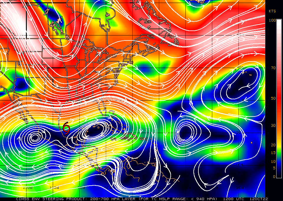
The map you showed is for storms stronger than 940 mb. It would be much more telling if you'd post the map that is for near 1,000 mb. Anyone have that?
Also, these maps are for current steering, which means they normally change at least a little as we go forward in time.
0 likes
Personal Forecast Disclaimer:
The posts in this forum are NOT official forecasts and should not be used as such. They are just the opinion of the poster and may or may not be backed by sound meteorological data. They are NOT endorsed by any professional institution or storm2k.org. For official information, please refer to the NHC and NWS products.
The posts in this forum are NOT official forecasts and should not be used as such. They are just the opinion of the poster and may or may not be backed by sound meteorological data. They are NOT endorsed by any professional institution or storm2k.org. For official information, please refer to the NHC and NWS products.
-
tropicwatch
- Category 5
- Posts: 3205
- Age: 60
- Joined: Sat Jun 02, 2007 10:01 am
- Location: Panama City Florida
- Contact:
Re: ATL: KARL - Tropical Storm - Discussion
4 likes
Tropicwatch
Agnes 72', Eloise 75, Elena 85', Kate 85', Charley 86', Florence 88', Beryl 94', Dean 95', Erin 95', Opal 95', Earl 98', Georges 98', Ivan 2004', Arlene 2005', Dennis 2005', Ida 2009' Debby 2012' Irma 2017' Michael 2018'
Agnes 72', Eloise 75, Elena 85', Kate 85', Charley 86', Florence 88', Beryl 94', Dean 95', Erin 95', Opal 95', Earl 98', Georges 98', Ivan 2004', Arlene 2005', Dennis 2005', Ida 2009' Debby 2012' Irma 2017' Michael 2018'
-
wxman57

- Moderator-Pro Met

- Posts: 22480
- Age: 66
- Joined: Sat Jun 21, 2003 8:06 pm
- Location: Houston, TX (southwest)
Re: ATL: KARL - Tropical Storm - Discussion
tropicwatch wrote:https://tropicwatch.info/750karl.jpg
That map indicates why Karl tracked northward over the past 24 hours. Steering currents are changing, and Karl has stopped its northerly movement. Ridge is building over it from the west, which will shove it south. It is still no threat to the northern Gulf. It's not tracking to the north.
2 likes
-
Aric Dunn
- Category 5
- Posts: 21228
- Age: 41
- Joined: Sun Sep 19, 2004 9:58 pm
- Location: Ready for the Chase.
- Contact:
Re: ATL: KARL - Tropical Storm - Discussion
Recon. finidng a solid 60 mph now around the developing core. also it is a full degree north and east of models and NHC forecast.
Still moving NE

Still moving NE
4 likes
Note: If I make a post that is brief. Please refer back to previous posts for the analysis or reasoning. I do not re-write/qoute what my initial post said each time.
If there is nothing before... then just ask
Space & Atmospheric Physicist, Embry-Riddle Aeronautical University,
I believe the sky is falling...
If there is nothing before... then just ask
Space & Atmospheric Physicist, Embry-Riddle Aeronautical University,
I believe the sky is falling...
Re: ATL: KARL - Tropical Storm - Discussion
tropicwatch wrote:https://tropicwatch.info/750karl.jpg
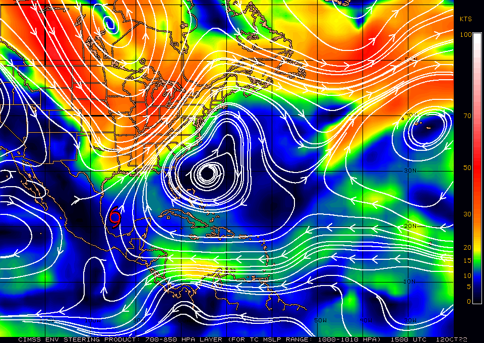
Thanks for posting the steering map that covers the current SLP. As this shows, steering is to the NNE *currently* and thus the slow NNE to NE move today has made sense. But keep in mind that some models like UKMET have had Karl move slowly NE today. However, those same models then have had any NE move stop by tomorrow at the latest followed by a drift back SSE to SE (in UKMET case at least) as the steering changes.
To best illustrate, here's the brand new UKMET (12Z), which has Karl continue to move NE slowly until hour 24 (12Z on Oct 13) when the latitude peaks at 22.1N. That is then followed by a SSE move from hour 24 to hour 72, when the latitude goes from 22.1N to 20.0N as the steering changes to SSE from the current NE:
TROPICAL STORM KARL ANALYSED POSITION : 21.6N 95.0W
ATCF IDENTIFIER : AL142022
LEAD CENTRAL MAXIMUM WIND
VERIFYING TIME TIME POSITION PRESSURE (MB) SPEED (KNOTS)
-------------- ---- -------- ------------- -------------
1200UTC 12.10.2022 0 21.6N 95.0W 1008 28
0000UTC 13.10.2022 12 22.0N 94.6W 1007 29
1200UTC 13.10.2022 24 22.1N 94.4W 1007 25
0000UTC 14.10.2022 36 21.4N 94.0W 1006 25
1200UTC 14.10.2022 48 20.6N 93.6W 1007 25
0000UTC 15.10.2022 60 20.2N 93.3W 1006 29
1200UTC 15.10.2022 72 20.0N 93.8W 1008 30
0000UTC 16.10.2022 84 CEASED TRACKING
0 likes
Personal Forecast Disclaimer:
The posts in this forum are NOT official forecasts and should not be used as such. They are just the opinion of the poster and may or may not be backed by sound meteorological data. They are NOT endorsed by any professional institution or storm2k.org. For official information, please refer to the NHC and NWS products.
The posts in this forum are NOT official forecasts and should not be used as such. They are just the opinion of the poster and may or may not be backed by sound meteorological data. They are NOT endorsed by any professional institution or storm2k.org. For official information, please refer to the NHC and NWS products.
-
Aric Dunn
- Category 5
- Posts: 21228
- Age: 41
- Joined: Sun Sep 19, 2004 9:58 pm
- Location: Ready for the Chase.
- Contact:
Re: ATL: KARL - Tropical Storm - Discussion
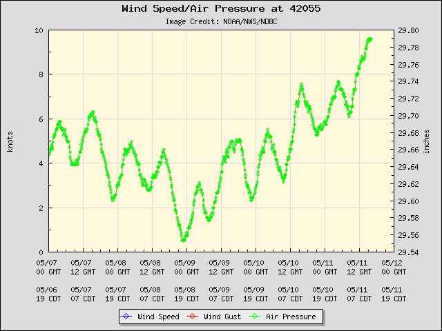
BOuy
3 likes
Note: If I make a post that is brief. Please refer back to previous posts for the analysis or reasoning. I do not re-write/qoute what my initial post said each time.
If there is nothing before... then just ask
Space & Atmospheric Physicist, Embry-Riddle Aeronautical University,
I believe the sky is falling...
If there is nothing before... then just ask
Space & Atmospheric Physicist, Embry-Riddle Aeronautical University,
I believe the sky is falling...

Re: ATL: KARL - Tropical Storm - Discussion
Forecasting a track in a different direction where the system actually stalls first is difficult.
Might make a little loop around to the east then SE or just stall and then drift south?
Might make a little loop around to the east then SE or just stall and then drift south?
0 likes
Re: ATL: KARL - Tropical Storm - Discussion
Aric Dunn wrote:Recon. finidng a solid 60 mph now around the developing core. also it is a full degree north and east of models and NHC forecast.
Still moving NE
https://i.ibb.co/KF9WX7X/recon.png
It is definitely not anywhere near a full degree NE of the 12Z UKMET, which has it near 21.9N, 94.7W now (per interpolation taking into account that it is progged to slow down shortly when looking at another site's maps). That compares to the current 21.9N, 94.6W, per recon. So, this run is almost spot on currently. This run then has it go as far north as 22.1 by tomorrow morning:
-------------
1200UTC 12.10.2022 0 21.6N 95.0W 1008 28
0000UTC 13.10.2022 12 22.0N 94.6W 1007 29
1200UTC 13.10.2022 24 22.1N 94.4W 1007 25
0000UTC 14.10.2022 36 21.4N 94.0W 1006 25
1 likes
Personal Forecast Disclaimer:
The posts in this forum are NOT official forecasts and should not be used as such. They are just the opinion of the poster and may or may not be backed by sound meteorological data. They are NOT endorsed by any professional institution or storm2k.org. For official information, please refer to the NHC and NWS products.
The posts in this forum are NOT official forecasts and should not be used as such. They are just the opinion of the poster and may or may not be backed by sound meteorological data. They are NOT endorsed by any professional institution or storm2k.org. For official information, please refer to the NHC and NWS products.
-
Aric Dunn
- Category 5
- Posts: 21228
- Age: 41
- Joined: Sun Sep 19, 2004 9:58 pm
- Location: Ready for the Chase.
- Contact:
Re: ATL: KARL - Tropical Storm - Discussion
LarryWx wrote:Aric Dunn wrote:Recon. finidng a solid 60 mph now around the developing core. also it is a full degree north and east of models and NHC forecast.
Still moving NE
https://i.ibb.co/KF9WX7X/recon.png
It is definitely not anywhere near a full degree NE of the 12Z UKMET, which has it near 21.9N, 94.7W now (per interpolation taking into account that it is progged to slow down shortly when looking at another site's maps). That compares to the current 21.9N, 94.6W, per recon. So, this run is almost spot on currently. This run then has it go as far north as 22.1 by tomorrow morning:
-------------
1200UTC 12.10.2022 0 21.6N 95.0W 1008 28
0000UTC 13.10.2022 12 22.0N 94.6W 1007 29
1200UTC 13.10.2022 24 22.1N 94.4W 1007 25
0000UTC 14.10.2022 36 21.4N 94.0W 1006 25
barely look at the UKMET these days. but using a current model run to compare near real time is not a verification. what was the 00z UKMET showing.
2 likes
Note: If I make a post that is brief. Please refer back to previous posts for the analysis or reasoning. I do not re-write/qoute what my initial post said each time.
If there is nothing before... then just ask
Space & Atmospheric Physicist, Embry-Riddle Aeronautical University,
I believe the sky is falling...
If there is nothing before... then just ask
Space & Atmospheric Physicist, Embry-Riddle Aeronautical University,
I believe the sky is falling...
-
cycloneye

- Admin

- Posts: 139011
- Age: 67
- Joined: Thu Oct 10, 2002 10:54 am
- Location: San Juan, Puerto Rico
Re: ATL: KARL - Tropical Storm - Discussion
Tropical Storm Karl Tropical Cyclone Update
NWS National Hurricane Center Miami FL AL142022
1235 PM CDT Wed Oct 12 2022
...AIR FORCE RESERVE RECONNAISSANCE AIRCRAFT FINDS KARL STRONGER...
Data from an Air Force Reserve reconnaissance aircraft indicate
that Karl has strengthened. The maximum sustained winds are
estimated to be 60 mph (95 km/h) with higher gusts. A special
advisory will be issued by 1 PM CDT (1800 UTC) to reflect the
higher initial intensity and it will replace the intermediate
advisory.
SUMMARY OF 1235 PM CDT...1735 UTC...INFORMATION
-----------------------------------------------
LOCATION...22.0N 94.5W
ABOUT 200 MI...320 KM ENE OF VERACRUZ MEXICO
MAXIMUM SUSTAINED WINDS...60 MPH...95 KM/H
PRESENT MOVEMENT...N OR 010 DEGREES AT 3 MPH...6 KM/H
MINIMUM CENTRAL PRESSURE...1002 MB...29.59 INCHES
$$
Forecaster Brown/Bucci
7 likes
Visit the Caribbean-Central America Weather Thread where you can find at first post web cams,radars
and observations from Caribbean basin members Click Here
and observations from Caribbean basin members Click Here
-
wxman57
- Moderator-Pro Met
- Posts: 22480
- Age: 66
- Joined: Sat Jun 21, 2003 8:06 pm
- Location: Houston, TX (southwest)
Re: ATL: KARL - Tropical Storm - Discussion
I'm not seeing any significant farther northward movement in the past couple of hours on high-res satellite imagery. I think it's reached about as far north as it will get. Movement to the south begins tonight/tomorrow. Consensus has south movement starting around 8PM Central today.
2 likes
-
ThunderForce

- Tropical Storm

- Posts: 158
- Age: 25
- Joined: Tue Sep 27, 2022 6:20 pm
- Location: Florida Panhandle
Re: ATL: KARL - Tropical Storm - Discussion
I can't say I was expecting Karl's wind speed to suddenly increase by 15 MPH.
3 likes
Please refer to the NWS, NHC, SPC or a professional meteorologist for information and decision making during storms.
Re: ATL: KARL - Tropical Storm - Discussion
Aric Dunn wrote:LarryWx wrote:Aric Dunn wrote:Recon. finidng a solid 60 mph now around the developing core. also it is a full degree north and east of models and NHC forecast.
Still moving NE
https://i.ibb.co/KF9WX7X/recon.png
It is definitely not anywhere near a full degree NE of the 12Z UKMET, which has it near 21.9N, 94.7W now (per interpolation taking into account that it is progged to slow down shortly when looking at another site's maps). That compares to the current 21.9N, 94.6W, per recon. So, this run is almost spot on currently. This run then has it go as far north as 22.1 by tomorrow morning:
-------------
1200UTC 12.10.2022 0 21.6N 95.0W 1008 28
0000UTC 13.10.2022 12 22.0N 94.6W 1007 29
1200UTC 13.10.2022 24 22.1N 94.4W 1007 25
0000UTC 14.10.2022 36 21.4N 94.0W 1006 25
barely look at the UKMET these days. but using a current model run to compare near real time is not a verification. what was the 00z UKMET showing.
But you said it was a full degree N of models and that clearly isn't the case as regards the nearly spot on 12Z UKMET. And keep in mind that this run initialized over 5 hours ago.
Here's the 0Z UKMET, which had it near 22.0N, 94.9W as of recon time vs actual of ~21.9N, ~94.6W. So, the actual recon vs 0Z run was ~0.1 to the SOUTH and ~0.3 to the east, which again is nowhere near the full degree north that you said:
TROPICAL STORM KARL ANALYSED POSITION : 20.6N 95.7W
ATCF IDENTIFIER : AL142022
LEAD CENTRAL MAXIMUM WIND
VERIFYING TIME TIME POSITION PRESSURE (MB) SPEED (KNOTS)
-------------- ---- -------- ------------- -------------
0000UTC 12.10.2022 0 20.6N 95.7W 1008 33
1200UTC 12.10.2022 12 21.7N 94.9W 1008 28
0000UTC 13.10.2022 24 22.2N 95.1W 1007 27
1200UTC 13.10.2022 36 22.3N 95.2W 1007 25
1 likes
Personal Forecast Disclaimer:
The posts in this forum are NOT official forecasts and should not be used as such. They are just the opinion of the poster and may or may not be backed by sound meteorological data. They are NOT endorsed by any professional institution or storm2k.org. For official information, please refer to the NHC and NWS products.
The posts in this forum are NOT official forecasts and should not be used as such. They are just the opinion of the poster and may or may not be backed by sound meteorological data. They are NOT endorsed by any professional institution or storm2k.org. For official information, please refer to the NHC and NWS products.
-
Aric Dunn
- Category 5
- Posts: 21228
- Age: 41
- Joined: Sun Sep 19, 2004 9:58 pm
- Location: Ready for the Chase.
- Contact:
Re: ATL: KARL - Tropical Storm - Discussion
LarryWx wrote:Aric Dunn wrote:LarryWx wrote:
It is definitely not anywhere near a full degree NE of the 12Z UKMET, which has it near 21.9N, 94.7W now (per interpolation taking into account that it is progged to slow down shortly when looking at another site's maps). That compares to the current 21.9N, 94.6W, per recon. So, this run is almost spot on currently. This run then has it go as far north as 22.1 by tomorrow morning:
-------------
1200UTC 12.10.2022 0 21.6N 95.0W 1008 28
0000UTC 13.10.2022 12 22.0N 94.6W 1007 29
1200UTC 13.10.2022 24 22.1N 94.4W 1007 25
0000UTC 14.10.2022 36 21.4N 94.0W 1006 25
barely look at the UKMET these days. but using a current model run to compare near real time is not a verification. what was the 00z UKMET showing.
But you said it was a full degree N of models and that clearly isn't the case as regards the nearly spot on 12Z UKMET. And keep in mind that this run initialized over 5 hours ago.
Here's the 0Z UKMET, which had it near 22.0N, 94.9W as of recon time vs actual of ~21.9N, ~94.6W. So, the actual recon vs 0Z run was ~0.1 to the SOUTH and ~0.3 to the east, which again is nowhere near the full degree north that you said:
TROPICAL STORM KARL ANALYSED POSITION : 20.6N 95.7W
ATCF IDENTIFIER : AL142022
LEAD CENTRAL MAXIMUM WIND
VERIFYING TIME TIME POSITION PRESSURE (MB) SPEED (KNOTS)
-------------- ---- -------- ------------- -------------
0000UTC 12.10.2022 0 20.6N 95.7W 1008 33
1200UTC 12.10.2022 12 21.7N 94.9W 1008 28
0000UTC 13.10.2022 24 22.2N 95.1W 1007 27
1200UTC 13.10.2022 36 22.3N 95.2W 1007 25
Cool thanks Ill keep an eye out for future ukmet runs
0 likes
Note: If I make a post that is brief. Please refer back to previous posts for the analysis or reasoning. I do not re-write/qoute what my initial post said each time.
If there is nothing before... then just ask
Space & Atmospheric Physicist, Embry-Riddle Aeronautical University,
I believe the sky is falling...
If there is nothing before... then just ask
Space & Atmospheric Physicist, Embry-Riddle Aeronautical University,
I believe the sky is falling...
-
Sciencerocks
- Category 5
- Posts: 7282
- Age: 38
- Joined: Thu Jul 06, 2017 1:51 am
-
Iceresistance

- Category 5
- Posts: 8909
- Age: 20
- Joined: Sat Oct 10, 2020 9:45 am
- Location: Tecumseh, OK/Norman, OK
Re: ATL: KARL - Tropical Storm - Discussion
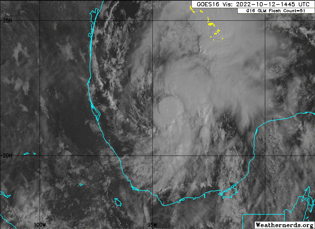
Made a really strong zoom in to the Center of Karl, he's doing better than he was this morning.

https://s4.gifyu.com/images/16689903.gif
https://s4.gifyu.com/images/16689903.gif
4 likes
Bill 2015 & Beta 2020
Winter 2020-2021
All observations are in Tecumseh, OK unless otherwise noted.
Winter posts are focused mainly for Oklahoma & Texas.
Take any of my forecasts with a grain of salt, refer to the NWS, SPC, and NHC for official information
Never say Never with weather! Because ANYTHING is possible!
Winter 2020-2021
All observations are in Tecumseh, OK unless otherwise noted.
Winter posts are focused mainly for Oklahoma & Texas.
Take any of my forecasts with a grain of salt, refer to the NWS, SPC, and NHC for official information
Never say Never with weather! Because ANYTHING is possible!
-
tropicwatch
- Category 5
- Posts: 3205
- Age: 60
- Joined: Sat Jun 02, 2007 10:01 am
- Location: Panama City Florida
- Contact:
Re: ATL: KARL - Tropical Storm - Discussion
Next HH about 2hrs. from takeoff.
3 likes
Tropicwatch
Agnes 72', Eloise 75, Elena 85', Kate 85', Charley 86', Florence 88', Beryl 94', Dean 95', Erin 95', Opal 95', Earl 98', Georges 98', Ivan 2004', Arlene 2005', Dennis 2005', Ida 2009' Debby 2012' Irma 2017' Michael 2018'
Agnes 72', Eloise 75, Elena 85', Kate 85', Charley 86', Florence 88', Beryl 94', Dean 95', Erin 95', Opal 95', Earl 98', Georges 98', Ivan 2004', Arlene 2005', Dennis 2005', Ida 2009' Debby 2012' Irma 2017' Michael 2018'
Re: ATL: KARL - Tropical Storm - Discussion
The National Hurricane Center shows Karls 7am Thursday position south/southwest of where it is located today, on a course towards a landfall in southern Mexico where preparations should be made for tropical storm conditions during the forecasted period, designated by the National Hurricane Center....
0 likes
-
THC_Scientist

- Tropical Wave

- Posts: 9
- Joined: Thu Sep 22, 2022 10:08 pm
Re: ATL: KARL - Tropical Storm - Discussion
wxman57 wrote:I'm not seeing any significant farther northward movement in the past couple of hours on high-res satellite imagery. I think it's reached about as far north as it will get. Movement to the south begins tonight/tomorrow. Consensus has south movement starting around 8PM Central today.
Our voice of reason! Too late in the game for Karl.
1 likes
Who is online
Users browsing this forum: No registered users and 9 guests