EPAC: ROSLYN - Remnants
Moderator: S2k Moderators

Re: EPAC: ROSLYN - Tropical Storm
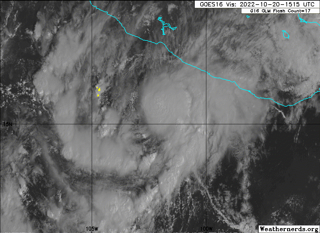
There still looks to be some shear underneath the excellent UL setup. If this shear ablates and Roslyn is able to organize better during the next 24-30 hours, the stage could be set for a crazy RI phase this weekend. However, this is a La Niña year, and surprise shear is always abundant close to Mexico and Central America. Even Julia in the Atlantic dealt with shear underneath its UL setup that was missed by every single model.
1 likes
Irene '11 Sandy '12 Hermine '16 5/15/2018 Derecho Fay '20 Isaias '20 Elsa '21 Henri '21 Ida '21
I am only a meteorology enthusiast who knows a decent amount about tropical cyclones. Look to the professional mets, the NHC, or your local weather office for the best information.
I am only a meteorology enthusiast who knows a decent amount about tropical cyclones. Look to the professional mets, the NHC, or your local weather office for the best information.
-
Sciencerocks
- Category 5

- Posts: 7286
- Age: 38
- Joined: Thu Jul 06, 2017 1:51 am
-
Yellow Evan

- Professional-Met

- Posts: 15954
- Age: 25
- Joined: Fri Jul 15, 2011 12:48 pm
- Location: Henderson, Nevada/Honolulu, HI
- Contact:
Re: EPAC: ROSLYN - Tropical Storm
This shear profile resembles an Atlantic storm by the Antilles with almost non-existent flow at mid-levels leading to a westerly mid-level shear vector. The net shear isn't much around 10-14 knots looking at GFS/HWRF AA soundings but apparently it's enough to yield a partially exposed center. HWRF agrees on a convective burst tonight as the shear subsides slightly overnight but the wind profile doesn't change radically until Saturday, in which flow becomes east to east-southeasterly throughout.
0 likes
-
Yellow Evan
- Professional-Met
- Posts: 15954
- Age: 25
- Joined: Fri Jul 15, 2011 12:48 pm
- Location: Henderson, Nevada/Honolulu, HI
- Contact:
Re: EPAC: ROSLYN - Tropical Storm
TXPZ22 KNES 201812
TCSENP
A. 19E (ROSLYN)
B. 20/1730Z
C. 15.8N
D. 102.8W
E. THREE/GOES-E
F. T2.5/2.5
G. IR/EIR/VIS
H. REMARKS...5.5/10 BANDING RESULTS IN A DT OF 2.5. THE MET IS 1.5 AND
THE PT IS 2.0. THE FT IS BASED ON THE DT.
I. ADDL POSITIONS
NIL
...BROWN
TCSENP
A. 19E (ROSLYN)
B. 20/1730Z
C. 15.8N
D. 102.8W
E. THREE/GOES-E
F. T2.5/2.5
G. IR/EIR/VIS
H. REMARKS...5.5/10 BANDING RESULTS IN A DT OF 2.5. THE MET IS 1.5 AND
THE PT IS 2.0. THE FT IS BASED ON THE DT.
I. ADDL POSITIONS
NIL
...BROWN
0 likes
-
Yellow Evan
- Professional-Met
- Posts: 15954
- Age: 25
- Joined: Fri Jul 15, 2011 12:48 pm
- Location: Henderson, Nevada/Honolulu, HI
- Contact:
Re: EPAC: ROSLYN - Tropical Storm
EP, 19, 2022102018, , BEST, 0, 154N, 1026W, 40, 1005, TS, 34, NEQ, 50, 0, 0, 0, 1011, 120, 40, 0, 0, E, 0, , 0, 0, ROSLYN, M, 0, , 0, 0, 0, 0, genesis-num, 033,
0 likes
-
Yellow Evan
- Professional-Met
- Posts: 15954
- Age: 25
- Joined: Fri Jul 15, 2011 12:48 pm
- Location: Henderson, Nevada/Honolulu, HI
- Contact:
Re: EPAC: ROSLYN - Tropical Storm
* GFS version *
* EAST PACIFIC 2021 SHIPS INTENSITY FORECAST *
* IR SAT DATA AVAILABLE, OHC AVAILABLE *
* ROSLYN EP192022 10/20/22 18 UTC *
TIME (HR) 0 6 12 18 24 36 48 60 72 84 96 108 120 132 144 156 168
V (KT) NO LAND 40 42 44 45 48 51 56 48 43 41 36 38 40 42 44 45 46
V (KT) LAND 40 42 44 45 48 51 56 48 43 33 29 27 27 27 27 27 27
V (KT) LGEM 40 43 46 48 50 52 52 48 46 36 29 N/A N/A N/A N/A N/A N/A
Storm Type TROP TROP TROP TROP TROP TROP TROP TROP TROP TROP TROP N/A N/A N/A N/A N/A N/A
SHEAR (KT) 4 6 5 7 7 9 9 18 10 23 39 N/A N/A N/A N/A N/A N/A
SHEAR ADJ (KT) 0 -2 -5 -8 -7 -4 -5 -6 -4 3 6 N/A N/A N/A N/A N/A N/A
SHEAR DIR 256 254 266 255 212 200 166 183 211 228 245 N/A N/A N/A N/A N/A N/A
SST (C) 30.0 30.2 30.3 30.3 30.1 29.5 28.9 29.0 29.4 27.9 27.7 N/A N/A N/A N/A N/A N/A
POT. INT. (KT) 163 165 166 166 164 158 153 154 159 144 142 N/A N/A N/A N/A N/A N/A
200 MB T (C) -53.3 -53.0 -53.3 -53.5 -53.2 -53.5 -53.3 -53.5 -53.6 -53.5 -53.5 N/A N/A N/A N/A N/A N/A
200 MB VXT (C) 0.1 0.0 0.0 0.1 0.2 0.3 0.3 0.3 0.0 0.0 0.0 N/A N/A N/A N/A N/A N/A
TH_E DEV (C) 6 6 5 5 6 6 6 5 6 5 6 N/A N/A N/A N/A N/A N/A
700-500 MB RH 69 69 68 66 65 62 60 55 51 54 46 N/A N/A N/A N/A N/A N/A
MODEL VTX (KT) 13 13 14 13 14 12 14 6 LOST LOST LOST LOST LOST LOST LOST LOST LOST
850 MB ENV VOR -17 -4 -4 -1 1 12 10 30 20 23 11 N/A N/A N/A N/A N/A N/A
200 MB DIV 60 54 47 29 21 44 59 54 52 12 -8 N/A N/A N/A N/A N/A N/A
700-850 TADV -1 -1 -2 -1 -2 -4 0 -2 4 7 9 N/A N/A N/A N/A N/A N/A
LAND (KM) 271 280 280 273 274 268 207 102 61 -97 -342 N/A N/A N/A N/A N/A N/A
LAT (DEG N) 15.4 15.5 15.6 15.9 16.1 16.8 17.9 19.6 21.3 23.1 25.1 N/A N/A N/A N/A N/A N/A
LONG(DEG W) 102.6 103.1 103.6 104.1 104.5 105.4 106.2 106.3 106.0 105.0 103.7 N/A N/A N/A N/A N/A N/A
STM SPEED (KT) 5 5 5 5 5 6 7 9 9 11 11 N/A N/A N/A N/A N/A N/A
HEAT CONTENT 37 36 35 35 34 29 21 18 24 10 7 N/A N/A N/A N/A N/A N/A
FORECAST TRACK FROM OFCI INITIAL HEADING/SPEED (DEG/KT):280/ 6 CX,CY: -5/ 1
T-12 MAX WIND: 30 PRESSURE OF STEERING LEVEL (MB): 630 (MEAN=587)
GOES IR BRIGHTNESS TEMP. STD DEV. 50-200 KM RAD: 22.7 (MEAN=14.5)
% GOES IR PIXELS WITH T < -20 C 50-200 KM RAD: 67.0 (MEAN=65.0)
PRELIM RI PROB (DV .GE. 35 KT IN 36 HR): 16.3
INDIVIDUAL CONTRIBUTIONS TO INTENSITY CHANGE
6 12 18 24 36 48 60 72 84 96 108 120 132 144 156 168
------------------------------------------------------------------------------
SAMPLE MEAN CHANGE 0. 0. 1. 1. 1. 2. 1. 1. 0. -0. -1. -2. -2. -3. -4. -4.
SST POTENTIAL 0. 0. 1. 2. 6. 10. 15. 19. 22. 24. 26. 28. 30. 32. 33. 35.
VERTICAL SHEAR MAG 1. 1. 2. 3. 4. 5. 4. 3. 1. -4. -5. -5. -5. -5. -7. -8.
VERTICAL SHEAR ADJ 0. 0. 1. 2. 3. 3. 3. 2. 1. 1. 0. 0. 0. 0. 1. 1.
VERTICAL SHEAR DIR -1. -1. -2. -3. -5. -6. -6. -6. -6. -4. -4. -4. -4. -4. -3. -3.
PERSISTENCE 2. 3. 3. 3. 3. 2. 2. 2. 2. 2. 2. 2. 2. 2. 2. 2.
200/250 MB TEMP. 0. 0. 0. -0. -0. -1. -1. -1. -2. -1. -1. -1. -1. -1. -0. -1.
THETA_E EXCESS -0. -0. -0. -0. -0. -1. -1. -1. -1. -2. -2. -2. -2. -2. -3. -3.
700-500 MB RH 0. 0. 0. 0. 0. 0. 0. -0. -0. -0. -0. -0. -0. -0. -0. -0.
MODEL VTX TENDENCY -0. 0. -0. 0. -1. 0. -9. -15. -15. -15. -14. -13. -12. -11. -10. -9.
850 MB ENV VORTICITY -0. -0. -0. -0. -0. 0. 0. 0. 0. 0. 1. 1. 1. 1. 1. 1.
200 MB DIVERGENCE 0. 0. 0. 0. 0. 0. 1. 1. 1. 0. 0. 0. 0. 0. -0. -0.
850-700 T ADVEC 0. 0. 0. 0. 0. -0. -0. -0. 0. 0. 0. 0. 0. 0. 1. 1.
ZONAL STORM MOTION -0. -0. -0. -0. -0. -1. -1. -1. -1. -1. -1. -1. -1. -0. -0. 0.
STEERING LEVEL PRES 0. 0. 0. 0. 1. 1. 1. 1. 1. 1. 1. 1. 1. 1. 1. 0.
DAYS FROM CLIM. PEAK -0. -0. -0. -0. -0. -0. -1. -1. -1. -2. -2. -2. -3. -3. -4. -4.
GOES PREDICTORS -0. -1. -1. -1. -1. -1. -1. -1. -1. -2. -2. -2. -2. -2. -1. -0.
OCEAN HEAT CONTENT 0. 0. 0. 0. 0. 1. 1. 1. 0. 0. -0. -0. -1. -1. -2. -3.
RI POTENTIAL 0. 0. 1. 1. 1. 1. 0. 0. 0. 0. 0. 0. 1. 1. 1. 1.
------------------------------------------------------------------------------
TOTAL CHANGE 2. 4. 5. 8. 11. 16. 9. 3. 1. -4. -2. 0. 2. 4. 5. 6.
CURRENT MAX WIND (KT): 40. LAT, LON: 15.4 102.6
** 2021 E. Pacific RI INDEX EP192022 ROSLYN 10/20/22 18 UTC **
(SHIPS-RII PREDICTOR TABLE for 30 KT OR MORE MAXIMUM WIND INCREASE IN NEXT 24-h)
Predictor Value RI Predictor Range Scaled Value(0-1) % Contribution
POT = MPI-VMAX (KT) : 124.8 40.5 to 149.3 0.78 6.4
12 HR PERSISTENCE (KT) : 10.0 -22.0 to 44.0 0.48 4.6
D200 (10**7s-1) : 42.2 -33.0 to 159.5 0.39 3.0
850-200 MB SHEAR (KT) : 5.8 19.6 to 1.3 0.75 5.6
MAXIMUM WIND (KT) : 40.0 22.5 to 132.0 0.50 2.9
STD DEV OF IR BR TEMP : 22.7 37.8 to 2.1 0.42 2.2
BL DRY-AIR FLUX (W/M2) : 92.4 800.8 to -82.5 0.80 -4.7
HEAT CONTENT (KJ/CM2) : 35.4 2.7 to 106.7 0.31 1.4
%area of TPW <45 mm upshear : 0.0 56.6 to 0.0 1.00 1.6
2nd PC OF IR BR TEMP : 0.8 2.2 to -2.3 0.31 0.3
SHIPS Prob RI for 20kt/ 12hr RI threshold= 13% is 2.1 times climatological mean ( 6.3%)
SHIPS Prob RI for 25kt/ 24hr RI threshold= 25% is 2.0 times climatological mean (12.5%)
SHIPS Prob RI for 30kt/ 24hr RI threshold= 23% is 2.7 times climatological mean ( 8.6%)
SHIPS Prob RI for 35kt/ 24hr RI threshold= 23% is 3.7 times climatological mean ( 6.2%)
SHIPS Prob RI for 40kt/ 24hr RI threshold= 14% is 3.3 times climatological mean ( 4.2%)
SHIPS Prob RI for 45kt/ 36hr RI threshold= 24% is 3.6 times climatological mean ( 6.7%)
SHIPS Prob RI for 55kt/ 48hr RI threshold= 27% is 4.5 times climatological mean ( 5.9%)
SHIPS Prob RI for 65kt/ 72hr RI threshold= 21% is 4.5 times climatological mean ( 4.7%)
Matrix of RI probabilities
------------------------------------------------------------------------------
RI (kt / h) | 20/12 | 25/24 | 30/24 | 35/24 | 40/24 | 45/36 | 55/48 |65/72
------------------------------------------------------------------------------
SHIPS-RII: 12.9% 25.3% 23.3% 22.9% 13.8% 24.1% 26.7% 21.3%
Logistic: 10.6% 33.5% 20.4% 13.4% 8.0% 13.2% 11.7% 6.1%
Bayesian: 3.2% 19.1% 4.3% 1.0% 1.9% 2.0% 1.3% 0.3%
Consensus: 8.9% 25.9% 16.0% 12.4% 7.9% 13.1% 13.2% 9.2%
DTOPS: 2.0% 19.0% 11.0% 6.0% 6.0% 9.0% 14.0% 6.0%
## ANNULAR HURRICANE INDEX (AHI) EP192022 ROSLYN 10/20/22 18 UTC ##
## STORM NOT ANNULAR, SCREENING STEP FAILED, NPASS=2 NFAIL=5 ##
## AHI= 0 (AHI OF 100 IS BEST FIT TO ANN. STRUC., 1 IS MARGINAL, 0 IS NOT ANNULAR) ##
0 likes
-
Iceresistance

- Category 5
- Posts: 8915
- Age: 20
- Joined: Sat Oct 10, 2020 9:45 am
- Location: Tecumseh, OK/Norman, OK
Re: EPAC: ROSLYN - Tropical Storm
ADT is nearly at a 3.
UW - CIMSS
ADVANCED DVORAK TECHNIQUE
ADT-Version 9.0
Tropical Cyclone Intensity Algorithm
----- Current Analysis -----
Date : 20 OCT 2022 Time : 195020 UTC
Lat : 15:19:04 N Lon : 102:26:51 W
CI# /Pressure/ Vmax
2.9 / 1002mb / 43kts
Final T# Adj T# Raw T#
2.9 3.0 3.0
Center Temp : -57.0C Cloud Region Temp : -55.8C
Scene Type : IRREGULAR CDO
0 likes
Bill 2015 & Beta 2020
Winter 2020-2021
All observations are in Tecumseh, OK unless otherwise noted.
Winter posts are focused mainly for Oklahoma & Texas.
Take any of my forecasts with a grain of salt, refer to the NWS, SPC, and NHC for official information
Never say Never with weather! Because ANYTHING is possible!
Winter 2020-2021
All observations are in Tecumseh, OK unless otherwise noted.
Winter posts are focused mainly for Oklahoma & Texas.
Take any of my forecasts with a grain of salt, refer to the NWS, SPC, and NHC for official information
Never say Never with weather! Because ANYTHING is possible!
-
Sciencerocks
- Category 5
- Posts: 7286
- Age: 38
- Joined: Thu Jul 06, 2017 1:51 am
-
cycloneye

- Admin

- Posts: 139109
- Age: 67
- Joined: Thu Oct 10, 2002 10:54 am
- Location: San Juan, Puerto Rico
Re: EPAC: ROSLYN - Tropical Storm
BULLETIN
Tropical Storm Roslyn Advisory Number 4
NWS National Hurricane Center Miami FL EP192022
400 PM CDT Thu Oct 20 2022
...ROSLYN STRENGTHENS A LITTLE...
...TROPICAL STORM WATCH ISSUED FOR PORTIONS OF THE COAST OF
MEXICO...
SUMMARY OF 400 PM CDT...2100 UTC...INFORMATION
----------------------------------------------
LOCATION...15.5N 103.0W
ABOUT 180 MI...285 KM SSW OF ZIHUATANEJO MEXICO
ABOUT 255 MI...415 KM SSE OF MANZANILLO MEXICO
MAXIMUM SUSTAINED WINDS...45 MPH...75 KM/H
PRESENT MOVEMENT...W OR 280 DEGREES AT 7 MPH...11 KM/H
MINIMUM CENTRAL PRESSURE...1004 MB...29.65 INCHES
Tropical Storm Roslyn Discussion Number 4
NWS National Hurricane Center Miami FL EP192022
400 PM CDT Thu Oct 20 2022
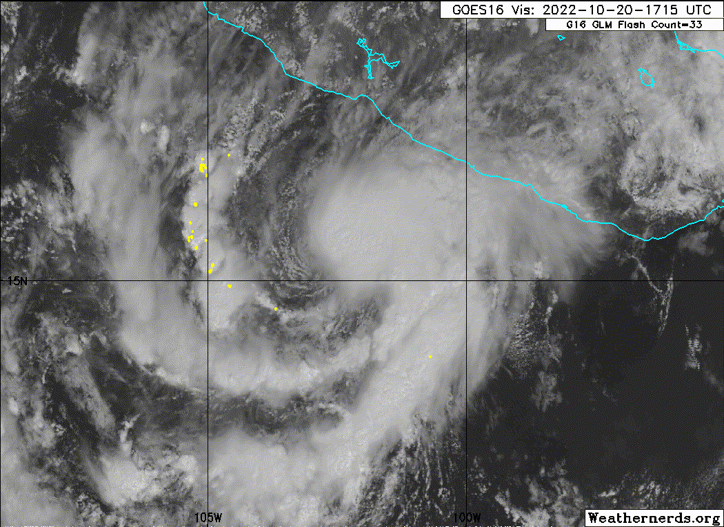
Satellite imagery shows that Roslyn has become a little more
organized this afternoon, with the formation of a curved convective
band near the center in the eastern semicircle. The various
subjective and objective satellite intensity estimates have
increased a little since the last advisory, and the initial
intensity is increased to 40 kt in best agreement with the CIMSS
satellite consensus. It should be noted that Roslyn looks a little
sheared, with the center near the western edge of the convection
and a lot of curved low cloud lines apparent west of the
convection. It is uncertain why the cyclone looks this way since
the analyzed vertical wind shear is less than 10 kt.
The initial motion is now 280/6 kt. A mid- to upper-level ridge is
located over Mexico north and northwest of Roslyn, while a
deep-layer low pressure area is located several hundred miles
southwest of the coast of southern California. The large-scale
models forecast both of these features to move eastward, with Roslyn
expected to recurve to the north and northeast between them. While
the track guidance is in good agreement with this general scenario,
there is a significant spread in the guidance regarding how far west
the cyclone will move before recurvature. The GFS is on the right
side of the envelope, bringing the center near Cabo Corrientes in
roughly 60 h and inland over mainland Mexico thereafter. On the
other hand, the ECMWF and UKMET are about 150 n mi west of the GFS
at that time, keeping the center farther offshore and showing a
more northerly landfall point in mainland Mexico. Overall, the
guidance envelope has shifted a little to the west since the last
advisory. The new forecast track is also shifted west of the
previous track, but it lies to the east of the consensus models out
of deference to the previous forecast and the GFS.
Roslyn remains over warm sea surface temperatures in a moist,
light-shear environment. These conditions are likely to persist
for the next 60-72 h, and they should allow Roslyn to steadily
intensify. After that time, the intensity forecast becomes more
uncertain due to a forecast increase in shear, the possibility of
dry air entrainment, and the uncertainty of how much land
interaction will occur. The new intensity forecast is again
similar to the previous forecast and calls for a peak intensity of
85 kt before landfall in mainland Mexico. After landfall, rapid
weakening is expected, with the cyclone dissipating over the
mountains of Mexico between 96-120 h.
Key Messages:
1. Roslyn is forecast to become a hurricane before it passes near
or over the west-central coast of Mexico late Saturday and Sunday,
accompanied by strong winds and a potentially dangerous storm surge.
Interests along the coast of southwestern and west-central Mexico
should closely monitor the progress of this system. A tropical
storm watch has been issued for part of this area, and additional
hurricane or tropical storm watches could be required tonight or
on Friday.
2. Heavy rainfall could lead to flash flooding and possible
landslides in areas of rugged terrain over coastal southwestern
Mexico.
FORECAST POSITIONS AND MAX WINDS
INIT 20/2100Z 15.5N 103.0W 40 KT 45 MPH
12H 21/0600Z 15.8N 103.7W 45 KT 50 MPH
24H 21/1800Z 16.3N 104.6W 55 KT 65 MPH
36H 22/0600Z 17.2N 105.7W 65 KT 75 MPH
48H 22/1800Z 18.5N 106.3W 75 KT 85 MPH
60H 23/0600Z 20.0N 106.5W 85 KT 100 MPH
72H 23/1800Z 21.8N 106.0W 85 KT 100 MPH
96H 24/1800Z 25.0N 104.5W 25 KT 30 MPH...INLAND
120H 25/1800Z...DISSIPATED
$$
Forecaster Beven
Tropical Storm Roslyn Advisory Number 4
NWS National Hurricane Center Miami FL EP192022
400 PM CDT Thu Oct 20 2022
...ROSLYN STRENGTHENS A LITTLE...
...TROPICAL STORM WATCH ISSUED FOR PORTIONS OF THE COAST OF
MEXICO...
SUMMARY OF 400 PM CDT...2100 UTC...INFORMATION
----------------------------------------------
LOCATION...15.5N 103.0W
ABOUT 180 MI...285 KM SSW OF ZIHUATANEJO MEXICO
ABOUT 255 MI...415 KM SSE OF MANZANILLO MEXICO
MAXIMUM SUSTAINED WINDS...45 MPH...75 KM/H
PRESENT MOVEMENT...W OR 280 DEGREES AT 7 MPH...11 KM/H
MINIMUM CENTRAL PRESSURE...1004 MB...29.65 INCHES
Tropical Storm Roslyn Discussion Number 4
NWS National Hurricane Center Miami FL EP192022
400 PM CDT Thu Oct 20 2022
Satellite imagery shows that Roslyn has become a little more
organized this afternoon, with the formation of a curved convective
band near the center in the eastern semicircle. The various
subjective and objective satellite intensity estimates have
increased a little since the last advisory, and the initial
intensity is increased to 40 kt in best agreement with the CIMSS
satellite consensus. It should be noted that Roslyn looks a little
sheared, with the center near the western edge of the convection
and a lot of curved low cloud lines apparent west of the
convection. It is uncertain why the cyclone looks this way since
the analyzed vertical wind shear is less than 10 kt.
The initial motion is now 280/6 kt. A mid- to upper-level ridge is
located over Mexico north and northwest of Roslyn, while a
deep-layer low pressure area is located several hundred miles
southwest of the coast of southern California. The large-scale
models forecast both of these features to move eastward, with Roslyn
expected to recurve to the north and northeast between them. While
the track guidance is in good agreement with this general scenario,
there is a significant spread in the guidance regarding how far west
the cyclone will move before recurvature. The GFS is on the right
side of the envelope, bringing the center near Cabo Corrientes in
roughly 60 h and inland over mainland Mexico thereafter. On the
other hand, the ECMWF and UKMET are about 150 n mi west of the GFS
at that time, keeping the center farther offshore and showing a
more northerly landfall point in mainland Mexico. Overall, the
guidance envelope has shifted a little to the west since the last
advisory. The new forecast track is also shifted west of the
previous track, but it lies to the east of the consensus models out
of deference to the previous forecast and the GFS.
Roslyn remains over warm sea surface temperatures in a moist,
light-shear environment. These conditions are likely to persist
for the next 60-72 h, and they should allow Roslyn to steadily
intensify. After that time, the intensity forecast becomes more
uncertain due to a forecast increase in shear, the possibility of
dry air entrainment, and the uncertainty of how much land
interaction will occur. The new intensity forecast is again
similar to the previous forecast and calls for a peak intensity of
85 kt before landfall in mainland Mexico. After landfall, rapid
weakening is expected, with the cyclone dissipating over the
mountains of Mexico between 96-120 h.
Key Messages:
1. Roslyn is forecast to become a hurricane before it passes near
or over the west-central coast of Mexico late Saturday and Sunday,
accompanied by strong winds and a potentially dangerous storm surge.
Interests along the coast of southwestern and west-central Mexico
should closely monitor the progress of this system. A tropical
storm watch has been issued for part of this area, and additional
hurricane or tropical storm watches could be required tonight or
on Friday.
2. Heavy rainfall could lead to flash flooding and possible
landslides in areas of rugged terrain over coastal southwestern
Mexico.
FORECAST POSITIONS AND MAX WINDS
INIT 20/2100Z 15.5N 103.0W 40 KT 45 MPH
12H 21/0600Z 15.8N 103.7W 45 KT 50 MPH
24H 21/1800Z 16.3N 104.6W 55 KT 65 MPH
36H 22/0600Z 17.2N 105.7W 65 KT 75 MPH
48H 22/1800Z 18.5N 106.3W 75 KT 85 MPH
60H 23/0600Z 20.0N 106.5W 85 KT 100 MPH
72H 23/1800Z 21.8N 106.0W 85 KT 100 MPH
96H 24/1800Z 25.0N 104.5W 25 KT 30 MPH...INLAND
120H 25/1800Z...DISSIPATED
$$
Forecaster Beven
0 likes
Visit the Caribbean-Central America Weather Thread where you can find at first post web cams,radars
and observations from Caribbean basin members Click Here
and observations from Caribbean basin members Click Here

Re: EPAC: ROSLYN - Tropical Storm
It is uncertain why the cyclone looks this way since
the analyzed vertical wind shear is less than 10 kt.
the analyzed vertical wind shear is less than 10 kt.
Sounds like story of the season
3 likes
Re: EPAC: ROSLYN - Tropical Storm
Yellow Evan wrote:* GFS version *
* EAST PACIFIC 2021 SHIPS INTENSITY FORECAST *
* IR SAT DATA AVAILABLE, OHC AVAILABLE *
* ROSLYN EP192022 10/20/22 18 UTC *
TIME (HR) 0 6 12 18 24 36 48 60 72 84 96 108 120 132 144 156 168
V (KT) NO LAND 40 42 44 45 48 51 56 48 43 41 36 38 40 42 44 45 46
V (KT) LAND 40 42 44 45 48 51 56 48 43 33 29 27 27 27 27 27 27
V (KT) LGEM 40 43 46 48 50 52 52 48 46 36 29 N/A N/A N/A N/A N/A N/A
Storm Type TROP TROP TROP TROP TROP TROP TROP TROP TROP TROP TROP N/A N/A N/A N/A N/A N/A
SHEAR (KT) 4 6 5 7 7 9 9 18 10 23 39 N/A N/A N/A N/A N/A N/A
SHEAR ADJ (KT) 0 -2 -5 -8 -7 -4 -5 -6 -4 3 6 N/A N/A N/A N/A N/A N/A
SHEAR DIR 256 254 266 255 212 200 166 183 211 228 245 N/A N/A N/A N/A N/A N/A
SST (C) 30.0 30.2 30.3 30.3 30.1 29.5 28.9 29.0 29.4 27.9 27.7 N/A N/A N/A N/A N/A N/A
POT. INT. (KT) 163 165 166 166 164 158 153 154 159 144 142 N/A N/A N/A N/A N/A N/A
200 MB T (C) -53.3 -53.0 -53.3 -53.5 -53.2 -53.5 -53.3 -53.5 -53.6 -53.5 -53.5 N/A N/A N/A N/A N/A N/A
200 MB VXT (C) 0.1 0.0 0.0 0.1 0.2 0.3 0.3 0.3 0.0 0.0 0.0 N/A N/A N/A N/A N/A N/A
TH_E DEV (C) 6 6 5 5 6 6 6 5 6 5 6 N/A N/A N/A N/A N/A N/A
700-500 MB RH 69 69 68 66 65 62 60 55 51 54 46 N/A N/A N/A N/A N/A N/A
MODEL VTX (KT) 13 13 14 13 14 12 14 6 LOST LOST LOST LOST LOST LOST LOST LOST LOST
850 MB ENV VOR -17 -4 -4 -1 1 12 10 30 20 23 11 N/A N/A N/A N/A N/A N/A
200 MB DIV 60 54 47 29 21 44 59 54 52 12 -8 N/A N/A N/A N/A N/A N/A
700-850 TADV -1 -1 -2 -1 -2 -4 0 -2 4 7 9 N/A N/A N/A N/A N/A N/A
LAND (KM) 271 280 280 273 274 268 207 102 61 -97 -342 N/A N/A N/A N/A N/A N/A
LAT (DEG N) 15.4 15.5 15.6 15.9 16.1 16.8 17.9 19.6 21.3 23.1 25.1 N/A N/A N/A N/A N/A N/A
LONG(DEG W) 102.6 103.1 103.6 104.1 104.5 105.4 106.2 106.3 106.0 105.0 103.7 N/A N/A N/A N/A N/A N/A
STM SPEED (KT) 5 5 5 5 5 6 7 9 9 11 11 N/A N/A N/A N/A N/A N/A
HEAT CONTENT 37 36 35 35 34 29 21 18 24 10 7 N/A N/A N/A N/A N/A N/A
FORECAST TRACK FROM OFCI INITIAL HEADING/SPEED (DEG/KT):280/ 6 CX,CY: -5/ 1
T-12 MAX WIND: 30 PRESSURE OF STEERING LEVEL (MB): 630 (MEAN=587)
GOES IR BRIGHTNESS TEMP. STD DEV. 50-200 KM RAD: 22.7 (MEAN=14.5)
% GOES IR PIXELS WITH T < -20 C 50-200 KM RAD: 67.0 (MEAN=65.0)
PRELIM RI PROB (DV .GE. 35 KT IN 36 HR): 16.3
INDIVIDUAL CONTRIBUTIONS TO INTENSITY CHANGE
6 12 18 24 36 48 60 72 84 96 108 120 132 144 156 168
------------------------------------------------------------------------------
SAMPLE MEAN CHANGE 0. 0. 1. 1. 1. 2. 1. 1. 0. -0. -1. -2. -2. -3. -4. -4.
SST POTENTIAL 0. 0. 1. 2. 6. 10. 15. 19. 22. 24. 26. 28. 30. 32. 33. 35.
VERTICAL SHEAR MAG 1. 1. 2. 3. 4. 5. 4. 3. 1. -4. -5. -5. -5. -5. -7. -8.
VERTICAL SHEAR ADJ 0. 0. 1. 2. 3. 3. 3. 2. 1. 1. 0. 0. 0. 0. 1. 1.
VERTICAL SHEAR DIR -1. -1. -2. -3. -5. -6. -6. -6. -6. -4. -4. -4. -4. -4. -3. -3.
PERSISTENCE 2. 3. 3. 3. 3. 2. 2. 2. 2. 2. 2. 2. 2. 2. 2. 2.
200/250 MB TEMP. 0. 0. 0. -0. -0. -1. -1. -1. -2. -1. -1. -1. -1. -1. -0. -1.
THETA_E EXCESS -0. -0. -0. -0. -0. -1. -1. -1. -1. -2. -2. -2. -2. -2. -3. -3.
700-500 MB RH 0. 0. 0. 0. 0. 0. 0. -0. -0. -0. -0. -0. -0. -0. -0. -0.
MODEL VTX TENDENCY -0. 0. -0. 0. -1. 0. -9. -15. -15. -15. -14. -13. -12. -11. -10. -9.
850 MB ENV VORTICITY -0. -0. -0. -0. -0. 0. 0. 0. 0. 0. 1. 1. 1. 1. 1. 1.
200 MB DIVERGENCE 0. 0. 0. 0. 0. 0. 1. 1. 1. 0. 0. 0. 0. 0. -0. -0.
850-700 T ADVEC 0. 0. 0. 0. 0. -0. -0. -0. 0. 0. 0. 0. 0. 0. 1. 1.
ZONAL STORM MOTION -0. -0. -0. -0. -0. -1. -1. -1. -1. -1. -1. -1. -1. -0. -0. 0.
STEERING LEVEL PRES 0. 0. 0. 0. 1. 1. 1. 1. 1. 1. 1. 1. 1. 1. 1. 0.
DAYS FROM CLIM. PEAK -0. -0. -0. -0. -0. -0. -1. -1. -1. -2. -2. -2. -3. -3. -4. -4.
GOES PREDICTORS -0. -1. -1. -1. -1. -1. -1. -1. -1. -2. -2. -2. -2. -2. -1. -0.
OCEAN HEAT CONTENT 0. 0. 0. 0. 0. 1. 1. 1. 0. 0. -0. -0. -1. -1. -2. -3.
RI POTENTIAL 0. 0. 1. 1. 1. 1. 0. 0. 0. 0. 0. 0. 1. 1. 1. 1.
------------------------------------------------------------------------------
TOTAL CHANGE 2. 4. 5. 8. 11. 16. 9. 3. 1. -4. -2. 0. 2. 4. 5. 6.
CURRENT MAX WIND (KT): 40. LAT, LON: 15.4 102.6
** 2021 E. Pacific RI INDEX EP192022 ROSLYN 10/20/22 18 UTC **
(SHIPS-RII PREDICTOR TABLE for 30 KT OR MORE MAXIMUM WIND INCREASE IN NEXT 24-h)
Predictor Value RI Predictor Range Scaled Value(0-1) % Contribution
POT = MPI-VMAX (KT) : 124.8 40.5 to 149.3 0.78 6.4
12 HR PERSISTENCE (KT) : 10.0 -22.0 to 44.0 0.48 4.6
D200 (10**7s-1) : 42.2 -33.0 to 159.5 0.39 3.0
850-200 MB SHEAR (KT) : 5.8 19.6 to 1.3 0.75 5.6
MAXIMUM WIND (KT) : 40.0 22.5 to 132.0 0.50 2.9
STD DEV OF IR BR TEMP : 22.7 37.8 to 2.1 0.42 2.2
BL DRY-AIR FLUX (W/M2) : 92.4 800.8 to -82.5 0.80 -4.7
HEAT CONTENT (KJ/CM2) : 35.4 2.7 to 106.7 0.31 1.4
%area of TPW <45 mm upshear : 0.0 56.6 to 0.0 1.00 1.6
2nd PC OF IR BR TEMP : 0.8 2.2 to -2.3 0.31 0.3
SHIPS Prob RI for 20kt/ 12hr RI threshold= 13% is 2.1 times climatological mean ( 6.3%)
SHIPS Prob RI for 25kt/ 24hr RI threshold= 25% is 2.0 times climatological mean (12.5%)
SHIPS Prob RI for 30kt/ 24hr RI threshold= 23% is 2.7 times climatological mean ( 8.6%)
SHIPS Prob RI for 35kt/ 24hr RI threshold= 23% is 3.7 times climatological mean ( 6.2%)
SHIPS Prob RI for 40kt/ 24hr RI threshold= 14% is 3.3 times climatological mean ( 4.2%)
SHIPS Prob RI for 45kt/ 36hr RI threshold= 24% is 3.6 times climatological mean ( 6.7%)
SHIPS Prob RI for 55kt/ 48hr RI threshold= 27% is 4.5 times climatological mean ( 5.9%)
SHIPS Prob RI for 65kt/ 72hr RI threshold= 21% is 4.5 times climatological mean ( 4.7%)
Matrix of RI probabilities
------------------------------------------------------------------------------
RI (kt / h) | 20/12 | 25/24 | 30/24 | 35/24 | 40/24 | 45/36 | 55/48 |65/72
------------------------------------------------------------------------------
SHIPS-RII: 12.9% 25.3% 23.3% 22.9% 13.8% 24.1% 26.7% 21.3%
Logistic: 10.6% 33.5% 20.4% 13.4% 8.0% 13.2% 11.7% 6.1%
Bayesian: 3.2% 19.1% 4.3% 1.0% 1.9% 2.0% 1.3% 0.3%
Consensus: 8.9% 25.9% 16.0% 12.4% 7.9% 13.1% 13.2% 9.2%
DTOPS: 2.0% 19.0% 11.0% 6.0% 6.0% 9.0% 14.0% 6.0%
## ANNULAR HURRICANE INDEX (AHI) EP192022 ROSLYN 10/20/22 18 UTC ##
## STORM NOT ANNULAR, SCREENING STEP FAILED, NPASS=2 NFAIL=5 ##
## AHI= 0 (AHI OF 100 IS BEST FIT TO ANN. STRUC., 1 IS MARGINAL, 0 IS NOT ANNULAR) ##
I don’t think I’ve ever seen such a bearish SHIPS intensity forecast for a ~30C, <10 kt, and ~70% RH environment.
0 likes
Irene '11 Sandy '12 Hermine '16 5/15/2018 Derecho Fay '20 Isaias '20 Elsa '21 Henri '21 Ida '21
I am only a meteorology enthusiast who knows a decent amount about tropical cyclones. Look to the professional mets, the NHC, or your local weather office for the best information.
I am only a meteorology enthusiast who knows a decent amount about tropical cyclones. Look to the professional mets, the NHC, or your local weather office for the best information.
-
Iceresistance
- Category 5
- Posts: 8915
- Age: 20
- Joined: Sat Oct 10, 2020 9:45 am
- Location: Tecumseh, OK/Norman, OK
Re: EPAC: ROSLYN - Tropical Storm
aspen wrote:Yellow Evan wrote:* GFS version *
* EAST PACIFIC 2021 SHIPS INTENSITY FORECAST *
* IR SAT DATA AVAILABLE, OHC AVAILABLE *
* ROSLYN EP192022 10/20/22 18 UTC *
TIME (HR) 0 6 12 18 24 36 48 60 72 84 96 108 120 132 144 156 168
V (KT) NO LAND 40 42 44 45 48 51 56 48 43 41 36 38 40 42 44 45 46
V (KT) LAND 40 42 44 45 48 51 56 48 43 33 29 27 27 27 27 27 27
V (KT) LGEM 40 43 46 48 50 52 52 48 46 36 29 N/A N/A N/A N/A N/A N/A
Storm Type TROP TROP TROP TROP TROP TROP TROP TROP TROP TROP TROP N/A N/A N/A N/A N/A N/A
SHEAR (KT) 4 6 5 7 7 9 9 18 10 23 39 N/A N/A N/A N/A N/A N/A
SHEAR ADJ (KT) 0 -2 -5 -8 -7 -4 -5 -6 -4 3 6 N/A N/A N/A N/A N/A N/A
SHEAR DIR 256 254 266 255 212 200 166 183 211 228 245 N/A N/A N/A N/A N/A N/A
SST (C) 30.0 30.2 30.3 30.3 30.1 29.5 28.9 29.0 29.4 27.9 27.7 N/A N/A N/A N/A N/A N/A
POT. INT. (KT) 163 165 166 166 164 158 153 154 159 144 142 N/A N/A N/A N/A N/A N/A
200 MB T (C) -53.3 -53.0 -53.3 -53.5 -53.2 -53.5 -53.3 -53.5 -53.6 -53.5 -53.5 N/A N/A N/A N/A N/A N/A
200 MB VXT (C) 0.1 0.0 0.0 0.1 0.2 0.3 0.3 0.3 0.0 0.0 0.0 N/A N/A N/A N/A N/A N/A
TH_E DEV (C) 6 6 5 5 6 6 6 5 6 5 6 N/A N/A N/A N/A N/A N/A
700-500 MB RH 69 69 68 66 65 62 60 55 51 54 46 N/A N/A N/A N/A N/A N/A
MODEL VTX (KT) 13 13 14 13 14 12 14 6 LOST LOST LOST LOST LOST LOST LOST LOST LOST
850 MB ENV VOR -17 -4 -4 -1 1 12 10 30 20 23 11 N/A N/A N/A N/A N/A N/A
200 MB DIV 60 54 47 29 21 44 59 54 52 12 -8 N/A N/A N/A N/A N/A N/A
700-850 TADV -1 -1 -2 -1 -2 -4 0 -2 4 7 9 N/A N/A N/A N/A N/A N/A
LAND (KM) 271 280 280 273 274 268 207 102 61 -97 -342 N/A N/A N/A N/A N/A N/A
LAT (DEG N) 15.4 15.5 15.6 15.9 16.1 16.8 17.9 19.6 21.3 23.1 25.1 N/A N/A N/A N/A N/A N/A
LONG(DEG W) 102.6 103.1 103.6 104.1 104.5 105.4 106.2 106.3 106.0 105.0 103.7 N/A N/A N/A N/A N/A N/A
STM SPEED (KT) 5 5 5 5 5 6 7 9 9 11 11 N/A N/A N/A N/A N/A N/A
HEAT CONTENT 37 36 35 35 34 29 21 18 24 10 7 N/A N/A N/A N/A N/A N/A
FORECAST TRACK FROM OFCI INITIAL HEADING/SPEED (DEG/KT):280/ 6 CX,CY: -5/ 1
T-12 MAX WIND: 30 PRESSURE OF STEERING LEVEL (MB): 630 (MEAN=587)
GOES IR BRIGHTNESS TEMP. STD DEV. 50-200 KM RAD: 22.7 (MEAN=14.5)
% GOES IR PIXELS WITH T < -20 C 50-200 KM RAD: 67.0 (MEAN=65.0)
PRELIM RI PROB (DV .GE. 35 KT IN 36 HR): 16.3
INDIVIDUAL CONTRIBUTIONS TO INTENSITY CHANGE
6 12 18 24 36 48 60 72 84 96 108 120 132 144 156 168
------------------------------------------------------------------------------
SAMPLE MEAN CHANGE 0. 0. 1. 1. 1. 2. 1. 1. 0. -0. -1. -2. -2. -3. -4. -4.
SST POTENTIAL 0. 0. 1. 2. 6. 10. 15. 19. 22. 24. 26. 28. 30. 32. 33. 35.
VERTICAL SHEAR MAG 1. 1. 2. 3. 4. 5. 4. 3. 1. -4. -5. -5. -5. -5. -7. -8.
VERTICAL SHEAR ADJ 0. 0. 1. 2. 3. 3. 3. 2. 1. 1. 0. 0. 0. 0. 1. 1.
VERTICAL SHEAR DIR -1. -1. -2. -3. -5. -6. -6. -6. -6. -4. -4. -4. -4. -4. -3. -3.
PERSISTENCE 2. 3. 3. 3. 3. 2. 2. 2. 2. 2. 2. 2. 2. 2. 2. 2.
200/250 MB TEMP. 0. 0. 0. -0. -0. -1. -1. -1. -2. -1. -1. -1. -1. -1. -0. -1.
THETA_E EXCESS -0. -0. -0. -0. -0. -1. -1. -1. -1. -2. -2. -2. -2. -2. -3. -3.
700-500 MB RH 0. 0. 0. 0. 0. 0. 0. -0. -0. -0. -0. -0. -0. -0. -0. -0.
MODEL VTX TENDENCY -0. 0. -0. 0. -1. 0. -9. -15. -15. -15. -14. -13. -12. -11. -10. -9.
850 MB ENV VORTICITY -0. -0. -0. -0. -0. 0. 0. 0. 0. 0. 1. 1. 1. 1. 1. 1.
200 MB DIVERGENCE 0. 0. 0. 0. 0. 0. 1. 1. 1. 0. 0. 0. 0. 0. -0. -0.
850-700 T ADVEC 0. 0. 0. 0. 0. -0. -0. -0. 0. 0. 0. 0. 0. 0. 1. 1.
ZONAL STORM MOTION -0. -0. -0. -0. -0. -1. -1. -1. -1. -1. -1. -1. -1. -0. -0. 0.
STEERING LEVEL PRES 0. 0. 0. 0. 1. 1. 1. 1. 1. 1. 1. 1. 1. 1. 1. 0.
DAYS FROM CLIM. PEAK -0. -0. -0. -0. -0. -0. -1. -1. -1. -2. -2. -2. -3. -3. -4. -4.
GOES PREDICTORS -0. -1. -1. -1. -1. -1. -1. -1. -1. -2. -2. -2. -2. -2. -1. -0.
OCEAN HEAT CONTENT 0. 0. 0. 0. 0. 1. 1. 1. 0. 0. -0. -0. -1. -1. -2. -3.
RI POTENTIAL 0. 0. 1. 1. 1. 1. 0. 0. 0. 0. 0. 0. 1. 1. 1. 1.
------------------------------------------------------------------------------
TOTAL CHANGE 2. 4. 5. 8. 11. 16. 9. 3. 1. -4. -2. 0. 2. 4. 5. 6.
CURRENT MAX WIND (KT): 40. LAT, LON: 15.4 102.6
** 2021 E. Pacific RI INDEX EP192022 ROSLYN 10/20/22 18 UTC **
(SHIPS-RII PREDICTOR TABLE for 30 KT OR MORE MAXIMUM WIND INCREASE IN NEXT 24-h)
Predictor Value RI Predictor Range Scaled Value(0-1) % Contribution
POT = MPI-VMAX (KT) : 124.8 40.5 to 149.3 0.78 6.4
12 HR PERSISTENCE (KT) : 10.0 -22.0 to 44.0 0.48 4.6
D200 (10**7s-1) : 42.2 -33.0 to 159.5 0.39 3.0
850-200 MB SHEAR (KT) : 5.8 19.6 to 1.3 0.75 5.6
MAXIMUM WIND (KT) : 40.0 22.5 to 132.0 0.50 2.9
STD DEV OF IR BR TEMP : 22.7 37.8 to 2.1 0.42 2.2
BL DRY-AIR FLUX (W/M2) : 92.4 800.8 to -82.5 0.80 -4.7
HEAT CONTENT (KJ/CM2) : 35.4 2.7 to 106.7 0.31 1.4
%area of TPW <45 mm upshear : 0.0 56.6 to 0.0 1.00 1.6
2nd PC OF IR BR TEMP : 0.8 2.2 to -2.3 0.31 0.3
SHIPS Prob RI for 20kt/ 12hr RI threshold= 13% is 2.1 times climatological mean ( 6.3%)
SHIPS Prob RI for 25kt/ 24hr RI threshold= 25% is 2.0 times climatological mean (12.5%)
SHIPS Prob RI for 30kt/ 24hr RI threshold= 23% is 2.7 times climatological mean ( 8.6%)
SHIPS Prob RI for 35kt/ 24hr RI threshold= 23% is 3.7 times climatological mean ( 6.2%)
SHIPS Prob RI for 40kt/ 24hr RI threshold= 14% is 3.3 times climatological mean ( 4.2%)
SHIPS Prob RI for 45kt/ 36hr RI threshold= 24% is 3.6 times climatological mean ( 6.7%)
SHIPS Prob RI for 55kt/ 48hr RI threshold= 27% is 4.5 times climatological mean ( 5.9%)
SHIPS Prob RI for 65kt/ 72hr RI threshold= 21% is 4.5 times climatological mean ( 4.7%)
Matrix of RI probabilities
------------------------------------------------------------------------------
RI (kt / h) | 20/12 | 25/24 | 30/24 | 35/24 | 40/24 | 45/36 | 55/48 |65/72
------------------------------------------------------------------------------
SHIPS-RII: 12.9% 25.3% 23.3% 22.9% 13.8% 24.1% 26.7% 21.3%
Logistic: 10.6% 33.5% 20.4% 13.4% 8.0% 13.2% 11.7% 6.1%
Bayesian: 3.2% 19.1% 4.3% 1.0% 1.9% 2.0% 1.3% 0.3%
Consensus: 8.9% 25.9% 16.0% 12.4% 7.9% 13.1% 13.2% 9.2%
DTOPS: 2.0% 19.0% 11.0% 6.0% 6.0% 9.0% 14.0% 6.0%
## ANNULAR HURRICANE INDEX (AHI) EP192022 ROSLYN 10/20/22 18 UTC ##
## STORM NOT ANNULAR, SCREENING STEP FAILED, NPASS=2 NFAIL=5 ##
## AHI= 0 (AHI OF 100 IS BEST FIT TO ANN. STRUC., 1 IS MARGINAL, 0 IS NOT ANNULAR) ##
I don’t think I’ve ever seen such a bearish SHIPS intensity forecast for a ~30C, <10 kt, and ~70% RH environment.
I think that it does not trust that area with the surprise wind shear it's having right now.
1 likes
Bill 2015 & Beta 2020
Winter 2020-2021
All observations are in Tecumseh, OK unless otherwise noted.
Winter posts are focused mainly for Oklahoma & Texas.
Take any of my forecasts with a grain of salt, refer to the NWS, SPC, and NHC for official information
Never say Never with weather! Because ANYTHING is possible!
Winter 2020-2021
All observations are in Tecumseh, OK unless otherwise noted.
Winter posts are focused mainly for Oklahoma & Texas.
Take any of my forecasts with a grain of salt, refer to the NWS, SPC, and NHC for official information
Never say Never with weather! Because ANYTHING is possible!
-
cycloneye
- Admin
- Posts: 139109
- Age: 67
- Joined: Thu Oct 10, 2002 10:54 am
- Location: San Juan, Puerto Rico
Re: EPAC: ROSLYN - Tropical Storm
TXPZ22 KNES 202347
TCSENP
A. 19E (ROSLYN)
B. 20/2330Z
C. 15.7N
D. 103.3W
E. THREE/GOES-E
F. T3.0/3.0
G. IR/EIR/SWIR
H. REMARKS...CONVECTION WRAPS 0.6 ON A LOG 10 SPIRAL FOR A DT OF
3.0. MET=2.5 AND PT=3.0. THE FT IS BASED ON THE DT.
I. ADDL POSITIONS
NIL
...KIM
TCSENP
A. 19E (ROSLYN)
B. 20/2330Z
C. 15.7N
D. 103.3W
E. THREE/GOES-E
F. T3.0/3.0
G. IR/EIR/SWIR
H. REMARKS...CONVECTION WRAPS 0.6 ON A LOG 10 SPIRAL FOR A DT OF
3.0. MET=2.5 AND PT=3.0. THE FT IS BASED ON THE DT.
I. ADDL POSITIONS
NIL
...KIM
0 likes
Visit the Caribbean-Central America Weather Thread where you can find at first post web cams,radars
and observations from Caribbean basin members Click Here
and observations from Caribbean basin members Click Here
-
InfernoFlameCat

- Category 5
- Posts: 1966
- Age: 21
- Joined: Mon Dec 14, 2020 10:52 am
- Location: Buford, GA
Re: EPAC: ROSLYN - Tropical Storm
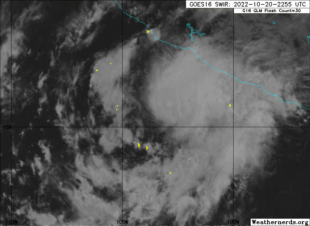
Storm looking much better. Rotating hot towers are forming.
0 likes
I am by no means a professional. DO NOT look at my forecasts for official information or make decisions based on what I post.
Goal: to become a registered expert over tropical and subtropical cyclones.
Goal: to become a registered expert over tropical and subtropical cyclones.
-
Hurricane2022

- Category 4

- Posts: 922
- Joined: Tue Aug 23, 2022 11:38 pm
- Location: Araçatuba, Brazil
Re: EPAC: ROSLYN - Tropical Storm
Any recent MW images? 
0 likes
Sorry for the bad English sometimes...!
For reliable and detailed information for any meteorological phenomenon, please consult the National Hurricane Center, Joint Typhoon Warning Center , or your local Meteo Center.
--------
Una cvm Christo, pro Christo, et in Christo. Sit nomen Domini benedictvm.
For reliable and detailed information for any meteorological phenomenon, please consult the National Hurricane Center, Joint Typhoon Warning Center , or your local Meteo Center.
--------
Una cvm Christo, pro Christo, et in Christo. Sit nomen Domini benedictvm.
-
Yellow Evan
- Professional-Met
- Posts: 15954
- Age: 25
- Joined: Fri Jul 15, 2011 12:48 pm
- Location: Henderson, Nevada/Honolulu, HI
- Contact:
Re: EPAC: ROSLYN - Tropical Storm
InfernoFlameCat wrote:Storm looking much better. Rotating hot towers are forming.
Not yet showing any signs of rotating upshear though.
0 likes
-
Yellow Evan
- Professional-Met
- Posts: 15954
- Age: 25
- Joined: Fri Jul 15, 2011 12:48 pm
- Location: Henderson, Nevada/Honolulu, HI
- Contact:


-
Hurricane2022
- Category 4
- Posts: 922
- Joined: Tue Aug 23, 2022 11:38 pm
- Location: Araçatuba, Brazil
Re: EPAC: ROSLYN - Tropical Storm
Yellow Evan wrote:Hurricane2022 wrote:Any recent MW images?
https://media.discordapp.net/attachments/857022688123682837/1032816183063347302/20221021.0001.f16.37pct37h37v.19E.ROSLYN.40kts.1005mb.15.4N.102.6W.075pc.jpg
https://media.discordapp.net/attachments/926509624142725190/1032814962411839618/image0.jpg
Maybe RI is underway?
0 likes
Sorry for the bad English sometimes...!
For reliable and detailed information for any meteorological phenomenon, please consult the National Hurricane Center, Joint Typhoon Warning Center , or your local Meteo Center.
--------
Una cvm Christo, pro Christo, et in Christo. Sit nomen Domini benedictvm.
For reliable and detailed information for any meteorological phenomenon, please consult the National Hurricane Center, Joint Typhoon Warning Center , or your local Meteo Center.
--------
Una cvm Christo, pro Christo, et in Christo. Sit nomen Domini benedictvm.
-
cycloneye
- Admin
- Posts: 139109
- Age: 67
- Joined: Thu Oct 10, 2002 10:54 am
- Location: San Juan, Puerto Rico
Re: EPAC: ROSLYN - Tropical Storm
EP, 19, 2022102100, , BEST, 0, 156N, 1033W, 45, 1001, TS
0 likes
Visit the Caribbean-Central America Weather Thread where you can find at first post web cams,radars
and observations from Caribbean basin members Click Here
and observations from Caribbean basin members Click Here
-
Sciencerocks
- Category 5
- Posts: 7286
- Age: 38
- Joined: Thu Jul 06, 2017 1:51 am
Who is online
Users browsing this forum: No registered users and 8 guests