ATL: LISA - Remnants - Discussion

Moderator: S2k Moderators

Message
Author
User avatar
cycloneye
Admin
Admin
Posts: 139151
Age: 67
Joined: Thu Oct 10, 2002 10:54 am
Location: San Juan, Puerto Rico

Re: ATL: INVEST 95L - Discussion

#21 Postby cycloneye » Fri Oct 28, 2022 8:22 pm

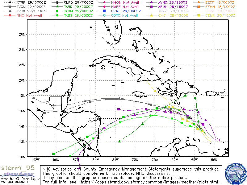
AL, 95, 2022102900, , BEST, 0, 130N, 672W, 20, 1009, DB


Image
0 likes   
Visit the Caribbean-Central America Weather Thread where you can find at first post web cams,radars
and observations from Caribbean basin members Click Here

User avatar
johngaltfla
Category 5
Category 5
Posts: 1938
Joined: Sun Jul 10, 2005 9:17 pm
Location: Sarasota County, FL
Contact:

Re: ATL: INVEST 95L - Discussion

#22 Postby johngaltfla » Fri Oct 28, 2022 9:17 pm

Shockingly enough the GFS hasn't developed this into a Cat 5 hitting Miami (yet).

Hopefully it's just a TS, this has been a weird season and I think more fishes and named fizzles would be better.
0 likes   

User avatar
GCANE
S2K Supporter
S2K Supporter
Posts: 10787
Joined: Mon Oct 22, 2007 8:03 am

Re: ATL: INVEST 95L - Discussion

#23 Postby GCANE » Sat Oct 29, 2022 5:03 am

Intermittent towers now firing very high rain rates.
Looks like it's improving
0 likes   

User avatar
tropicwatch
Category 5
Category 5
Posts: 3205
Age: 60
Joined: Sat Jun 02, 2007 10:01 am
Location: Panama City Florida
Contact:

Re: ATL: INVEST 95L - Discussion

#24 Postby tropicwatch » Sat Oct 29, 2022 5:15 am

Sure did lose a lot of convection last night. The Euro hasn't even iniated yet on the spaghetti model plots.

Image
0 likes   
Tropicwatch


Agnes 72', Eloise 75, Elena 85', Kate 85', Charley 86', Florence 88', Beryl 94', Dean 95', Erin 95', Opal 95', Earl 98', Georges 98', Ivan 2004', Arlene 2005', Dennis 2005', Ida 2009' Debby 2012' Irma 2017' Michael 2018'

User avatar
weeniepatrol
Category 3
Category 3
Posts: 859
Joined: Sat Aug 22, 2020 5:30 pm
Location: WA State

Re: ATL: INVEST 95L - Discussion

#25 Postby weeniepatrol » Sat Oct 29, 2022 5:23 am

Every time I open this site I'm confronted with the duality of S2K :lol:

Image
7 likes   

User avatar
cycloneye
Admin
Admin
Posts: 139151
Age: 67
Joined: Thu Oct 10, 2002 10:54 am
Location: San Juan, Puerto Rico

Re: ATL: INVEST 95L - Discussion

#26 Postby cycloneye » Sat Oct 29, 2022 6:43 am

8 AM TWO:

Eastern Caribbean:
A broad area of low pressure over the eastern Caribbean Sea is
producing a large area of disorganized showers and thunderstorms.
Environmental conditions are forecast to be conducive for gradual
development over the next few days, and a tropical depression is
likely to form by early next week while the disturbance moves slowly
westward or west-northwestward over the central Caribbean Sea.
Regardless of development, locally heavy rainfall is possible over
portions of the Lesser Antilles, the Virgin Islands, and Puerto Rico
through this weekend.
* Formation chance through 48 hours...medium...50 percent.
* Formation chance through 5 days...high...70 percent.
0 likes   
Visit the Caribbean-Central America Weather Thread where you can find at first post web cams,radars
and observations from Caribbean basin members Click Here

User avatar
GCANE
S2K Supporter
S2K Supporter
Posts: 10787
Joined: Mon Oct 22, 2007 8:03 am

Re: ATL: INVEST 95L - Discussion

#27 Postby GCANE » Sat Oct 29, 2022 7:16 am

weeniepatrol wrote:Every time I open this site I'm confronted with the duality of S2K :lol:

https://i.imgur.com/1tzfKwy.png


NHC went from yellow to orange on the 3-day. Think about that.
0 likes   

User avatar
GCANE
S2K Supporter
S2K Supporter
Posts: 10787
Joined: Mon Oct 22, 2007 8:03 am

Re: ATL: INVEST 95L - Discussion

#28 Postby GCANE » Sat Oct 29, 2022 7:29 am

Current GFS initialization shows a mismatch of surface winds and ASCAT data.
IMHO, not taking much faith how GFS is evolving this.
The only reliable and consistent forecast from GFS is the dissipation of the UL trough, north of Hispaniola, by Sunday.
This is confirmed by WV imagery currently showing convection well south of the island.
1 likes   

User avatar
GCANE
S2K Supporter
S2K Supporter
Posts: 10787
Joined: Mon Oct 22, 2007 8:03 am

Re: ATL: INVEST 95L - Discussion

#29 Postby GCANE » Sat Oct 29, 2022 7:31 am

GFS has a very strong ARWB anchored in the W Carib thru 11/3
0 likes   

User avatar
cycloneye
Admin
Admin
Posts: 139151
Age: 67
Joined: Thu Oct 10, 2002 10:54 am
Location: San Juan, Puerto Rico

Re: ATL: INVEST 95L - Discussion

#30 Postby cycloneye » Sat Oct 29, 2022 7:35 am

AL, 95, 2022102912, , BEST, 0, 137N, 693W, 20, 1009, DB
0 likes   
Visit the Caribbean-Central America Weather Thread where you can find at first post web cams,radars
and observations from Caribbean basin members Click Here

Sciencerocks
Category 5
Category 5
Posts: 7287
Age: 38
Joined: Thu Jul 06, 2017 1:51 am

Re: ATL: INVEST 95L - Discussion

#31 Postby Sciencerocks » Sat Oct 29, 2022 7:49 am

Image
1 likes   

User avatar
wxman57
Moderator-Pro Met
Moderator-Pro Met
Posts: 22482
Age: 66
Joined: Sat Jun 21, 2003 8:06 pm
Location: Houston, TX (southwest)

Re: ATL: INVEST 95L - Discussion

#32 Postby wxman57 » Sat Oct 29, 2022 8:41 am

Looks like an elongated circulation/wave axis. Still looks like the environment becomes more hostile by Monday/Tuesday, so its best short at becoming a TD or Lisa is the next 48 hrs. It’s 100% Central America-bound. No Gulf threat.
2 likes   

Sciencerocks
Category 5
Category 5
Posts: 7287
Age: 38
Joined: Thu Jul 06, 2017 1:51 am

Re: ATL: INVEST 95L - Discussion

#33 Postby Sciencerocks » Sat Oct 29, 2022 12:14 pm

Image
1 likes   

User avatar
tropicwatch
Category 5
Category 5
Posts: 3205
Age: 60
Joined: Sat Jun 02, 2007 10:01 am
Location: Panama City Florida
Contact:

Re: ATL: INVEST 95L - Discussion

#34 Postby tropicwatch » Sat Oct 29, 2022 12:31 pm

HH found a solid wind change. Now will they call it a TD?
0 likes   
Tropicwatch


Agnes 72', Eloise 75, Elena 85', Kate 85', Charley 86', Florence 88', Beryl 94', Dean 95', Erin 95', Opal 95', Earl 98', Georges 98', Ivan 2004', Arlene 2005', Dennis 2005', Ida 2009' Debby 2012' Irma 2017' Michael 2018'

User avatar
cycloneye
Admin
Admin
Posts: 139151
Age: 67
Joined: Thu Oct 10, 2002 10:54 am
Location: San Juan, Puerto Rico

Re: ATL: INVEST 95L - Discussion

#35 Postby cycloneye » Sat Oct 29, 2022 12:47 pm

Central Caribbean:
A broad area of low pressure over the central Caribbean Sea
continues to produce disorganized showers and thunderstorms.
Environmental conditions are forecast to be conducive for gradual
development over the next few days, and a tropical depression is
likely to form by early next week while the disturbance moves
west-northwestward at 10 to 15 mph over the central Caribbean Sea.
An Air Force Reserve Hurricane Hunter aircraft is currently
investigating the disturbance. Regardless of development, locally
heavy rainfall is possible over portions of the Lesser Antilles, the
Virgin Islands, and Puerto Rico through this weekend.
* Formation chance through 48 hours...medium...50 percent.
* Formation chance through 5 days...high...70 percent.
0 likes   
Visit the Caribbean-Central America Weather Thread where you can find at first post web cams,radars
and observations from Caribbean basin members Click Here

shansgonefishin
Tropical Low
Tropical Low
Posts: 12
Joined: Fri Aug 28, 2020 6:44 am

Re: ATL: INVEST 95L - Discussion

#36 Postby shansgonefishin » Sat Oct 29, 2022 12:56 pm

The latest update from the NHC seems to have more confidence in the general direction, removing the westward component from the previous update…
0 likes   

User avatar
tropicwatch
Category 5
Category 5
Posts: 3205
Age: 60
Joined: Sat Jun 02, 2007 10:01 am
Location: Panama City Florida
Contact:

Re: ATL: INVEST 95L - Discussion

#37 Postby tropicwatch » Sat Oct 29, 2022 1:44 pm

Strange pattern being flown by the HH.
0 likes   
Tropicwatch


Agnes 72', Eloise 75, Elena 85', Kate 85', Charley 86', Florence 88', Beryl 94', Dean 95', Erin 95', Opal 95', Earl 98', Georges 98', Ivan 2004', Arlene 2005', Dennis 2005', Ida 2009' Debby 2012' Irma 2017' Michael 2018'

Sciencerocks
Category 5
Category 5
Posts: 7287
Age: 38
Joined: Thu Jul 06, 2017 1:51 am

Re: ATL: INVEST 95L - Discussion

#38 Postby Sciencerocks » Sat Oct 29, 2022 1:51 pm

Looks like we have a closed LLC. ;) I suspect we'll have a depression by tomorrow and then a tropical storm...
0 likes   

User avatar
Jr0d
S2K Supporter
S2K Supporter
Posts: 1174
Joined: Tue Aug 27, 2019 10:52 am
Location: Cayo Hueso

Re: ATL: INVEST 95L - Discussion

#39 Postby Jr0d » Sat Oct 29, 2022 2:20 pm

johngaltfla wrote:Shockingly enough the GFS hasn't developed this into a Cat 5 hitting Miami (yet).

Hopefully it's just a TS, this has been a weird season and I think more fishes and named fizzles would be better.


All the more reason to be concerned in S. Florida and the Keys j/k sort of. We are still dealing with flood damages from Ian in Key West, while we should be very safe from this one as per wxman57 but I do know strong November storms often surprise us and the water in the Keys is still plenty warm as is the GoM loop...further north fortunately has cooled of significantly.
0 likes   

ChrisH-UK
Category 1
Category 1
Posts: 424
Joined: Sat May 29, 2021 8:22 am

Re: ATL: INVEST 95L - Discussion

#40 Postby ChrisH-UK » Sat Oct 29, 2022 2:55 pm

95L is showing as a broad circulation but no organization yet

0 likes   


Return to “2022”

Who is online

Users browsing this forum: No registered users and 20 guests