ATL: NICOLE - Models

Moderator: S2k Moderators

Message
Author
User avatar
SFLcane
S2K Supporter
S2K Supporter
Posts: 9607
Age: 46
Joined: Sat Jun 05, 2010 1:44 pm
Location: Lake Worth Florida

ATL: INVEST 98L - Discussion

#41 Postby SFLcane » Sun Nov 06, 2022 12:46 pm

Oooof!

Lights out west palm beach

Image
0 likes   

Michele B
Category 4
Category 4
Posts: 906
Joined: Thu Aug 25, 2016 8:08 am
Location: SWFL

Re: ATL: INVEST 98L - Models

#42 Postby Michele B » Sun Nov 06, 2022 12:47 pm

MetroMike wrote:
Blown Away wrote:[url]https://i.postimg.cc/yx8jGJc1/015-B0-D02-59-A9-4-E5-D-A44-E-54-E9-A6-E749-FE.jpg [/url]

12z ICON… Another SW shift with Cat 1 into Port St. Lucie..


ICON model is not really held in high regard and not used by the NHC for forecasting.


If I remember correctly, ICON did well with Ian.
0 likes   
Cleo - 1964, Betsy - 1965, David - 1979, Andrew - 1992, Charlie (Francis, Ivan, Jeanne) - 2004, Irma - 2017, Ian - 2022

User avatar
Blown Away
S2K Supporter
S2K Supporter
Posts: 9863
Joined: Wed May 26, 2004 6:17 am

Re: ATL: INVEST 98L - Models

#43 Postby Blown Away » Sun Nov 06, 2022 12:51 pm

Image
12z HWRF… Landfall @Stuart heading W through the Peninsula… Cat 1 hurricane… It wouldn’t surprise me if S shifts happen…
0 likes   
Hurricane Eye Experience: David 79, Irene 99, Frances 04, Jeanne 04, Wilma 05...
Hurricane Brush Experience: Andrew 92, Erin 95, Floyd 99, Matthew 16, Irma 17, Ian 22, Nicole 22…

LarryWx
Category 5
Category 5
Posts: 5703
Joined: Sun Sep 07, 2003 2:04 pm
Location: GA

Re: ATL: INVEST 98L - Models

#44 Postby LarryWx » Sun Nov 06, 2022 1:03 pm

12Z Euro 48 almost identical to 6Z Euro 54 and is 1 mb stronger (1003 mb).
Last edited by LarryWx on Sun Nov 06, 2022 1:06 pm, edited 1 time in total.
0 likes   
Personal Forecast Disclaimer:
The posts in this forum are NOT official forecasts and should not be used as such. They are just the opinion of the poster and may or may not be backed by sound meteorological data. They are NOT endorsed by any professional institution or storm2k.org. For official information, please refer to the NHC and NWS products.

LarryWx
Category 5
Category 5
Posts: 5703
Joined: Sun Sep 07, 2003 2:04 pm
Location: GA

Re: ATL: INVEST 98L - Models

#45 Postby LarryWx » Sun Nov 06, 2022 1:09 pm

12Z Euro 72 is just a tad NW of the 6Z Euro 78 and again at 1001 mb.
0 likes   
Personal Forecast Disclaimer:
The posts in this forum are NOT official forecasts and should not be used as such. They are just the opinion of the poster and may or may not be backed by sound meteorological data. They are NOT endorsed by any professional institution or storm2k.org. For official information, please refer to the NHC and NWS products.

LarryWx
Category 5
Category 5
Posts: 5703
Joined: Sun Sep 07, 2003 2:04 pm
Location: GA

Re: ATL: INVEST 98L - Models

#46 Postby LarryWx » Sun Nov 06, 2022 1:15 pm

12Z Euro landfalls at 96 near Stuart at 998 mb. Almost identical to 12Z UKMET on timing and location.
Last edited by LarryWx on Sun Nov 06, 2022 1:16 pm, edited 2 times in total.
0 likes   
Personal Forecast Disclaimer:
The posts in this forum are NOT official forecasts and should not be used as such. They are just the opinion of the poster and may or may not be backed by sound meteorological data. They are NOT endorsed by any professional institution or storm2k.org. For official information, please refer to the NHC and NWS products.

User avatar
ronjon
Category 5
Category 5
Posts: 4671
Joined: Fri Aug 19, 2005 5:17 pm
Location: Hernando Beach, FL

Re: ATL: INVEST 98L - Models

#47 Postby ronjon » Sun Nov 06, 2022 1:15 pm

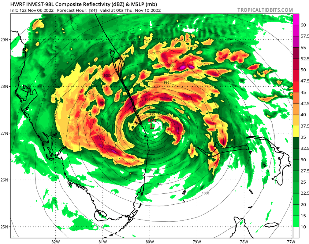
Blown Away wrote:[url]https://i.postimg.cc/BQprvJkW/hwrf-mslp-wind-98-L-fh0-96.gif [/url]
12z HWRF… Landfall @Stuart heading W through the Peninsula… Cat 1 hurricane… It wouldn’t surprise me if S shifts happen…


Me too BA. Synoptics are pretty well set with this one with huge low level and midlevel high anchored over the SW Atlantic ridging southwest into the SE US. Forward speed and storm strength will probably be the only variables affecting its track into the peninsula. Think because of that, this system track wise will be easier for the models to sort out than Ian, especially within that 48-72 hour window.
0 likes   

User avatar
cycloneye
Admin
Admin
Posts: 139116
Age: 67
Joined: Thu Oct 10, 2002 10:54 am
Location: San Juan, Puerto Rico

Re: ATL: INVEST 98L - Models

#48 Postby cycloneye » Sun Nov 06, 2022 1:18 pm

12z Euro.

Image
0 likes   
Visit the Caribbean-Central America Weather Thread where you can find at first post web cams,radars
and observations from Caribbean basin members Click Here

User avatar
wxman57
Moderator-Pro Met
Moderator-Pro Met
Posts: 22482
Age: 66
Joined: Sat Jun 21, 2003 8:06 pm
Location: Houston, TX (southwest)

Re: ATL: INVEST 98L - Models

#49 Postby wxman57 » Sun Nov 06, 2022 1:20 pm

GFS & HWRF are likely too strong. I don't think this will be tropical at landfall. I have it as a subtropical storm with TS winds extending out nearly 350 miles north and northeast of the center when it reaches FL Wednesday night. May have some 50kt winds over water north and northeast of the center. Transitions to fully ET as it tracks northeastward up the east coast on Saturday, moving at 35-40 mph.
2 likes   

User avatar
chris_fit
Category 5
Category 5
Posts: 3078
Joined: Wed Sep 10, 2003 11:58 pm
Location: Tampa Bay Area, FL
Contact:

Re: ATL: INVEST 98L - Models

#50 Postby chris_fit » Sun Nov 06, 2022 1:27 pm

00z Euro shifts to the right. Rides up near East FL.
0 likes   

User avatar
ThunderForce
Tropical Storm
Tropical Storm
Posts: 158
Age: 25
Joined: Tue Sep 27, 2022 6:20 pm
Location: Florida Panhandle

Re: ATL: INVEST 98L - Models

#51 Postby ThunderForce » Sun Nov 06, 2022 1:32 pm

Something odd I've noticed between the GFS and Euro is that Euro generally seems to have more dry air enter the low's core which seems to keep it weaker, whereas GFS has the storm blanket itself in humidity allowing it to intensify quickly.
0 likes   
Please refer to the NWS, NHC, SPC or a professional meteorologist for information and decision making during storms.

AutoPenalti
Category 5
Category 5
Posts: 3949
Age: 27
Joined: Mon Aug 17, 2015 4:16 pm
Location: Ft. Lauderdale, Florida

Re: ATL: INVEST 98L - Models

#52 Postby AutoPenalti » Sun Nov 06, 2022 1:32 pm

That HWRF run makes it look like metro dade and broward would get absolutely nothing, while a couple of miles north would be battered with rain and wind.
0 likes   
The posts in this forum are NOT official forecasts and should not be used as such. They are just the opinion of the poster and may or may not be backed by sound meteorological data. They are NOT endorsed by any professional institution or STORM2K. For official information, please refer to products from the NHC and NWS.


Model Runs Cheat Sheet:
GFS (5:30 AM/PM, 11:30 AM/PM)
HWRF, GFDL, UKMET, NAVGEM (6:30-8:00 AM/PM, 12:30-2:00 AM/PM)
ECMWF (1:45 AM/PM)

TCVN
is a weighted averaged

User avatar
jfk08c
S2K Supporter
S2K Supporter
Posts: 150
Joined: Mon Jun 11, 2018 4:36 pm
Location: Lakeland, FL

Re: ATL: INVEST 98L - Models

#53 Postby jfk08c » Sun Nov 06, 2022 1:35 pm

chris_fit wrote:00z Euro shifts to the right. Rides up near East FL.

12Z?
4 likes   

User avatar
blp
Category 5
Category 5
Posts: 2805
Age: 45
Joined: Thu Sep 09, 2004 7:51 pm
Location: Miami, FL
Contact:

Re: ATL: INVEST 98L - Models

#54 Postby blp » Sun Nov 06, 2022 1:52 pm

South shift in 12z GEFS

Image
1 likes   
The following post is NOT an official forecast and should not be used as such. It is just the opinion of the poster and may or may not be backed by sound meteorological data. It is NOT endorsed by any professional institution including storm2k.org For Official Information please refer to the NHC and NWS products.

User avatar
chris_fit
Category 5
Category 5
Posts: 3078
Joined: Wed Sep 10, 2003 11:58 pm
Location: Tampa Bay Area, FL
Contact:

Re: ATL: INVEST 98L - Models

#55 Postby chris_fit » Sun Nov 06, 2022 1:55 pm

jfk08c wrote:
chris_fit wrote:00z Euro shifts to the right. Rides up near East FL.

12Z?


Yup, my bad
0 likes   

jlauderdal
S2K Supporter
S2K Supporter
Posts: 6772
Joined: Wed May 19, 2004 5:46 am
Location: NE Fort Lauderdale
Contact:

Re: RE: Re: ATL: INVEST 98L - Models

#56 Postby jlauderdal » Sun Nov 06, 2022 2:17 pm

Michele B wrote:
MetroMike wrote:
Blown Away wrote:[url]https://i.postimg.cc/yx8jGJc1/015-B0-D02-59-A9-4-E5-D-A44-E-54-E9-A6-E749-FE.jpg [/url]

12z ICON… Another SW shift with Cat 1 into Port St. Lucie..


ICON model is not really held in high regard and not used by the NHC for forecasting.


If I remember correctly, ICON did well with Ian.
It did, so did the ukmet
1 likes   

User avatar
blp
Category 5
Category 5
Posts: 2805
Age: 45
Joined: Thu Sep 09, 2004 7:51 pm
Location: Miami, FL
Contact:

Re: ATL: INVEST 98L - Models

#57 Postby blp » Sun Nov 06, 2022 2:32 pm

EPS is south of the OPS.

Image

Loop
Image
0 likes   
The following post is NOT an official forecast and should not be used as such. It is just the opinion of the poster and may or may not be backed by sound meteorological data. It is NOT endorsed by any professional institution including storm2k.org For Official Information please refer to the NHC and NWS products.

User avatar
cycloneye
Admin
Admin
Posts: 139116
Age: 67
Joined: Thu Oct 10, 2002 10:54 am
Location: San Juan, Puerto Rico

Re: ATL: INVEST 98L - Models

#58 Postby cycloneye » Sun Nov 06, 2022 2:50 pm

1 likes   
Visit the Caribbean-Central America Weather Thread where you can find at first post web cams,radars
and observations from Caribbean basin members Click Here

User avatar
ronjon
Category 5
Category 5
Posts: 4671
Joined: Fri Aug 19, 2005 5:17 pm
Location: Hernando Beach, FL

Re: ATL: INVEST 98L - Models

#59 Postby ronjon » Sun Nov 06, 2022 3:09 pm

chris_fit wrote:
jfk08c wrote:
chris_fit wrote:00z Euro shifts to the right. Rides up near East FL.

12Z?


Yup, my bad


Actually no. Those were the 24 hr plots. It actually moves w-nw to Tampa Bay from Stuart and then pivots N-NE to JAX.
4 likes   

User avatar
Jr0d
S2K Supporter
S2K Supporter
Posts: 1174
Joined: Tue Aug 27, 2019 10:52 am
Location: Cayo Hueso

Re: ATL: INVEST 98L - Models

#60 Postby Jr0d » Sun Nov 06, 2022 3:12 pm

Based on the GFS, this does not become fully tropical until Wednesday morning, showing the 'core' separate from the rest of the system based on their simulated IR satellite. The CMC's simulated IR does not look tropical until Thursday. Both show an eye forming.

In my opinion, if this can become fully tropical, it will have a window to strengthen to a hurricane.

I do think the SW dive that all the modems are picking up on is a big factor, the further south it goes the stronger this can get.
3 likes   


Return to “2022”

Who is online

Users browsing this forum: No registered users and 15 guests