ATL: NICOLE - Models

Moderator: S2k Moderators

Message
Author
cane5
Tropical Storm
Tropical Storm
Posts: 249
Joined: Fri Jul 02, 2021 4:24 pm

Re: ATL: NICOLE - Models

#421 Postby cane5 » Tue Nov 08, 2022 5:23 pm

Nuno wrote:
jlauderdal wrote:
Blown Away wrote:
How does, if any, would a stronger deeper hurricane moving WSW respond to a very strong HP?? Past examples they go farther S? Does this apply here?

Look at Katrina, was heading right at me, I was ready to go in the eye and boom, takes the big dive and rolls through the everglades.


Let me leave this right here for everyone else who doesn't remember Katrina...

https://imgur.com/zwiNLn7

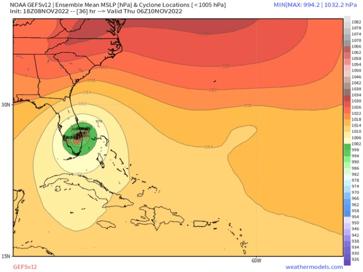
I'm used to too many of these ATL storms under strong high pressures being pushed further south than expected (Andrew, Ike, Irma, Katrina etc). Lots of conflicting models, but I would bet on this being closer to WPB or even Broward than the models are currently showing, with its current heading. Still gonna be nasty for everyone up the east coast no matter what.


Also the warm gulfstream waters have its own kind of effects. Suddenly feeling there is more time for this cosmic shift south. Also latest Sstallite looks to me it’s making that sw move ?
1 likes   

User avatar
Blown Away
S2K Supporter
S2K Supporter
Posts: 9863
Joined: Wed May 26, 2004 6:17 am

Re: ATL: NICOLE - Models

#422 Postby Blown Away » Tue Nov 08, 2022 5:25 pm

AutoPenalti wrote:Boca and miles south would get blasted by heavy rain.


Yep, Nicole will have that big calm eye probably @40 miles wide
0 likes   
Hurricane Eye Experience: David 79, Irene 99, Frances 04, Jeanne 04, Wilma 05...
Hurricane Brush Experience: Andrew 92, Erin 95, Floyd 99, Matthew 16, Irma 17, Ian 22, Nicole 22…

caneman
Category 5
Category 5
Posts: 1178
Joined: Fri Sep 05, 2014 5:44 am
Location: Clearwater Beach, Fl

Re: ATL: NICOLE - Models

#423 Postby caneman » Tue Nov 08, 2022 5:27 pm

Really can't argue with the Euro and GFS they have been steady. Rather shocked that the NHC gave so much weight towards the other models.
3 likes   

AxaltaRacing24
Category 5
Category 5
Posts: 1709
Age: 24
Joined: Wed Jul 27, 2016 11:14 am
Location: Jupiter, FL

Re: ATL: NICOLE - Models

#424 Postby AxaltaRacing24 » Tue Nov 08, 2022 5:56 pm

caneman wrote:Really can't argue with the Euro and GFS they have been steady. Rather shocked that the NHC gave so much weight towards the other models.

Hard to see the 2 best models in the world busting like this...
1 likes   

User avatar
SFLcane
S2K Supporter
S2K Supporter
Posts: 9614
Age: 46
Joined: Sat Jun 05, 2010 1:44 pm
Location: Lake Worth Florida

Re: ATL: NICOLE - Models

#425 Postby SFLcane » Tue Nov 08, 2022 6:07 pm

Going with a prediction 85-90mph hurricane near or over West Palm Beach.

Image
0 likes   

User avatar
Blown Away
S2K Supporter
S2K Supporter
Posts: 9863
Joined: Wed May 26, 2004 6:17 am

Re: ATL: NICOLE - Models

#426 Postby Blown Away » Tue Nov 08, 2022 6:07 pm

Image
18z HWRF... Landfall @Port St Lucie... Big shift SW
0 likes   
Hurricane Eye Experience: David 79, Irene 99, Frances 04, Jeanne 04, Wilma 05...
Hurricane Brush Experience: Andrew 92, Erin 95, Floyd 99, Matthew 16, Irma 17, Ian 22, Nicole 22…

jlauderdal
S2K Supporter
S2K Supporter
Posts: 6773
Joined: Wed May 19, 2004 5:46 am
Location: NE Fort Lauderdale
Contact:

Re: RE: Re: ATL: NICOLE - Models

#427 Postby jlauderdal » Tue Nov 08, 2022 6:12 pm

caneman wrote:Really can't argue with the Euro and GFS they have been steady. Rather shocked that the NHC gave so much weight towards the other models.
They gave a ton if weight to the tvcn, as usual.
0 likes   

User avatar
SFLcane
S2K Supporter
S2K Supporter
Posts: 9614
Age: 46
Joined: Sat Jun 05, 2010 1:44 pm
Location: Lake Worth Florida

Re: ATL: NICOLE - Models

#428 Postby SFLcane » Tue Nov 08, 2022 6:15 pm

Blown Away wrote:https://i.imgur.com/r6amsZo.gif
18z HWRF... Landfall @Port St Lucie... Big shift SW


Certainly appears the gfs might be on to something here.
0 likes   

jlauderdal
S2K Supporter
S2K Supporter
Posts: 6773
Joined: Wed May 19, 2004 5:46 am
Location: NE Fort Lauderdale
Contact:

Re: RE: Re: ATL: NICOLE - Models

#429 Postby jlauderdal » Tue Nov 08, 2022 6:34 pm

SFLcane wrote:
Blown Away wrote:https://i.imgur.com/r6amsZo.gif
18z HWRF... Landfall @Port St Lucie... Big shift SW


Certainly appears the gfs might be on to something here.
The GFS has it in for WPB, it keeps coming back.
1 likes   

User avatar
eastcoastFL
Category 5
Category 5
Posts: 3437
Age: 42
Joined: Thu Apr 12, 2007 12:29 pm
Location: Palm City, FL

Re: RE: Re: ATL: NICOLE - Models

#430 Postby eastcoastFL » Tue Nov 08, 2022 6:51 pm

jlauderdal wrote:
SFLcane wrote:
Blown Away wrote:https://i.imgur.com/r6amsZo.gif
18z HWRF... Landfall @Port St Lucie... Big shift SW


Certainly appears the gfs might be on to something here.
The GFS has it in for WPB, it keeps coming back.

I feel like that would be worse for me in Palm city than if it were to make landfall as forecast in PSL. Late night runs will be interesting. Guess I'm staying up
1 likes   
Personal Forecast Disclaimer:
The posts in this forum are NOT official forecast and should not be used as such. They are just the opinion of the poster and may or may not be backed by sound meteorological data. They are NOT endorsed by any professional institution or storm2k.org. For official information, please refer to the NHC and NWS products.

User avatar
toad strangler
S2K Supporter
S2K Supporter
Posts: 4165
Joined: Sun Jul 28, 2013 3:09 pm
Location: Earth
Contact:

Re: RE: Re: ATL: NICOLE - Models

#431 Postby toad strangler » Tue Nov 08, 2022 6:58 pm

eastcoastFL wrote:
jlauderdal wrote:
SFLcane wrote:
Certainly appears the gfs might be on to something here.
The GFS has it in for WPB, it keeps coming back.

I feel like that would be worse for me in Palm city than if it were to make landfall as forecast in PSL. Late night runs will be interesting. Guess I'm staying up


Landfall in WPB would be no bueno for Palm City and Port Saint Lucie.
3 likes   

jlauderdal
S2K Supporter
S2K Supporter
Posts: 6773
Joined: Wed May 19, 2004 5:46 am
Location: NE Fort Lauderdale
Contact:

Re: RE: Re: ATL: NICOLE - Models

#432 Postby jlauderdal » Tue Nov 08, 2022 7:07 pm

eastcoastFL wrote:
jlauderdal wrote:
SFLcane wrote:
Certainly appears the gfs might be on to something here.
The GFS has it in for WPB, it keeps coming back.

I feel like that would be worse for me in Palm city than if it were to make landfall as forecast in PSL. Late night runs will be interesting. Guess I'm staying up

Did you put up the shutters?
1 likes   

User avatar
eastcoastFL
Category 5
Category 5
Posts: 3437
Age: 42
Joined: Thu Apr 12, 2007 12:29 pm
Location: Palm City, FL

Re: RE: Re: ATL: NICOLE - Models

#433 Postby eastcoastFL » Tue Nov 08, 2022 7:25 pm

jlauderdal wrote:
eastcoastFL wrote:
jlauderdal wrote:The GFS has it in for WPB, it keeps coming back.

I feel like that would be worse for me in Palm city than if it were to make landfall as forecast in PSL. Late night runs will be interesting. Guess I'm staying up

Did you put up the shutters?


No, not yet. I didn’t have time this morning and it was dark when I got home tonight. I’m going to do it in the morning tomorrow if necessary.
0 likes   
Personal Forecast Disclaimer:
The posts in this forum are NOT official forecast and should not be used as such. They are just the opinion of the poster and may or may not be backed by sound meteorological data. They are NOT endorsed by any professional institution or storm2k.org. For official information, please refer to the NHC and NWS products.

User avatar
eastcoastFL
Category 5
Category 5
Posts: 3437
Age: 42
Joined: Thu Apr 12, 2007 12:29 pm
Location: Palm City, FL

Re: ATL: NICOLE - Models

#434 Postby eastcoastFL » Tue Nov 08, 2022 7:36 pm

Image
0 likes   
Personal Forecast Disclaimer:
The posts in this forum are NOT official forecast and should not be used as such. They are just the opinion of the poster and may or may not be backed by sound meteorological data. They are NOT endorsed by any professional institution or storm2k.org. For official information, please refer to the NHC and NWS products.

User avatar
SFLcane
S2K Supporter
S2K Supporter
Posts: 9614
Age: 46
Joined: Sat Jun 05, 2010 1:44 pm
Location: Lake Worth Florida

Re: ATL: NICOLE - Models

#435 Postby SFLcane » Tue Nov 08, 2022 7:39 pm


Lol apparently the gfs is on crack as the 00z models now shifted even further north. :double:
0 likes   

User avatar
sweetpea
S2K Supporter
S2K Supporter
Posts: 841
Age: 56
Joined: Fri Jun 10, 2005 5:49 pm
Location: Sopchoppy, FL

Re: ATL: NICOLE - Models

#436 Postby sweetpea » Tue Nov 08, 2022 7:40 pm


Hmm, almost all over my head on the second landfall. Not much being said about that, hope everyone stays safe on the East Coast!
0 likes   

User avatar
DESTRUCTION5
Category 5
Category 5
Posts: 4391
Age: 42
Joined: Wed Sep 03, 2003 11:25 am
Location: Stuart, FL

Re: ATL: NICOLE - Models

#437 Postby DESTRUCTION5 » Tue Nov 08, 2022 7:47 pm

SFLcane wrote:


Lol apparently the gfs is on crack as the 00z models now shifted even further north. :double:


Spaghetti plots all still way off raw data.
0 likes   
GATOR NATION IS E V E R Y W H E R E !

User avatar
eastcoastFL
Category 5
Category 5
Posts: 3437
Age: 42
Joined: Thu Apr 12, 2007 12:29 pm
Location: Palm City, FL

Re: ATL: NICOLE - Models

#438 Postby eastcoastFL » Tue Nov 08, 2022 7:47 pm

SFLcane wrote:


Lol apparently the gfs is on crack as the 00z models now shifted even further north. :double:


Sounds good to me, lol. I don’t know what to think anymore. We are far past the days of models being locked in with 48-72 hours to go. These home brew type storms are always so much harder to get a handle on than the long tracking types.
0 likes   
Personal Forecast Disclaimer:
The posts in this forum are NOT official forecast and should not be used as such. They are just the opinion of the poster and may or may not be backed by sound meteorological data. They are NOT endorsed by any professional institution or storm2k.org. For official information, please refer to the NHC and NWS products.

User avatar
eastcoastFL
Category 5
Category 5
Posts: 3437
Age: 42
Joined: Thu Apr 12, 2007 12:29 pm
Location: Palm City, FL

Re: ATL: NICOLE - Models

#439 Postby eastcoastFL » Tue Nov 08, 2022 7:48 pm

DESTRUCTION5 wrote:
SFLcane wrote:


Lol apparently the gfs is on crack as the 00z models now shifted even further north. :double:


Spaghetti plots all still way off raw data.


You mean they don’t include current recon data?
0 likes   
Personal Forecast Disclaimer:
The posts in this forum are NOT official forecast and should not be used as such. They are just the opinion of the poster and may or may not be backed by sound meteorological data. They are NOT endorsed by any professional institution or storm2k.org. For official information, please refer to the NHC and NWS products.

User avatar
DESTRUCTION5
Category 5
Category 5
Posts: 4391
Age: 42
Joined: Wed Sep 03, 2003 11:25 am
Location: Stuart, FL

Re: ATL: NICOLE - Models

#440 Postby DESTRUCTION5 » Tue Nov 08, 2022 7:54 pm

eastcoastFL wrote:
DESTRUCTION5 wrote:
SFLcane wrote:
Lol apparently the gfs is on crack as the 00z models now shifted even further north. :double:


Spaghetti plots all still way off raw data.


You mean they don’t include current recon data?


Long story short the spaghetti plots are 40-50 miles north than the raw data plots. See the 11am discussion about it. It's a few pages back.
1 likes   
GATOR NATION IS E V E R Y W H E R E !


Return to “2022”

Who is online

Users browsing this forum: No registered users and 25 guests