
ATL: LEE - Post-Tropical - Discussion
Moderator: S2k Moderators
-
Blown Away

- S2K Supporter

- Posts: 10253
- Joined: Wed May 26, 2004 6:17 am
Re: ATL: LEE - Hurricane - Discussion
Thank goodness Lee will most likely stay away from land at this crazy intensity…
0 likes
Hurricane Eye Experience: David 79, Irene 99, Frances 04, Jeanne 04, Wilma 05… Hurricane Brush Experience: Andrew 92, Erin 95, Floyd 99, Matthew 16, Irma 17, Ian 22, Nicole 22…
-
WalterWhite

- Category 1

- Posts: 342
- Joined: Fri Mar 17, 2023 5:53 pm
Re: ATL: LEE - Hurricane - Discussion
The SE quadrant does not appear to be particularly impressive from the recon data.
0 likes
-
eastcoastFL

- Category 5

- Posts: 3996
- Age: 44
- Joined: Thu Apr 12, 2007 12:29 pm
- Location: Palm City, FL
Re: ATL: LEE - Hurricane - Discussion
Iceresistance wrote:Here is the chart
https://s11.gifyu.com/images/SgX8Q.png
https://s11.gifyu.com/images/SgX8Q.png
The rain rate is nuts too
1 likes
Personal Forecast Disclaimer:
The posts in this forum are NOT official forecast and should not be used as such. They are just the opinion of the poster and may or may not be backed by sound meteorological data. They are NOT endorsed by any professional institution or storm2k.org. For official information, please refer to the NHC and NWS products.
The posts in this forum are NOT official forecast and should not be used as such. They are just the opinion of the poster and may or may not be backed by sound meteorological data. They are NOT endorsed by any professional institution or storm2k.org. For official information, please refer to the NHC and NWS products.

Re: ATL: LEE - Hurricane - Discussion
GCANE wrote:Looks like they got a secondary wind max outbound.
It’s really really close to the primary max, so I think we’re going to see an Irma-like eyewall meld, something that the hurricane models have been showing for a while. Just a lot earlier than they modeled.
1 likes
Irene '11 Sandy '12 Hermine '16 5/15/2018 Derecho Fay '20 Isaias '20 Elsa '21 Henri '21 Ida '21
I am only a meteorology enthusiast who knows a decent amount about tropical cyclones. Look to the professional mets, the NHC, or your local weather office for the best information.
I am only a meteorology enthusiast who knows a decent amount about tropical cyclones. Look to the professional mets, the NHC, or your local weather office for the best information.
-
SconnieCane
- Category 5
- Posts: 1013
- Joined: Thu Aug 02, 2018 5:29 pm
- Location: Madison, WI
Re: ATL: LEE - Hurricane - Discussion
So, @GCANE you were saying it's still not perfectly positioned relative to the ULAC? And it's STILL intensifying like this?
0 likes
Re: ATL: LEE - Hurricane - Discussion
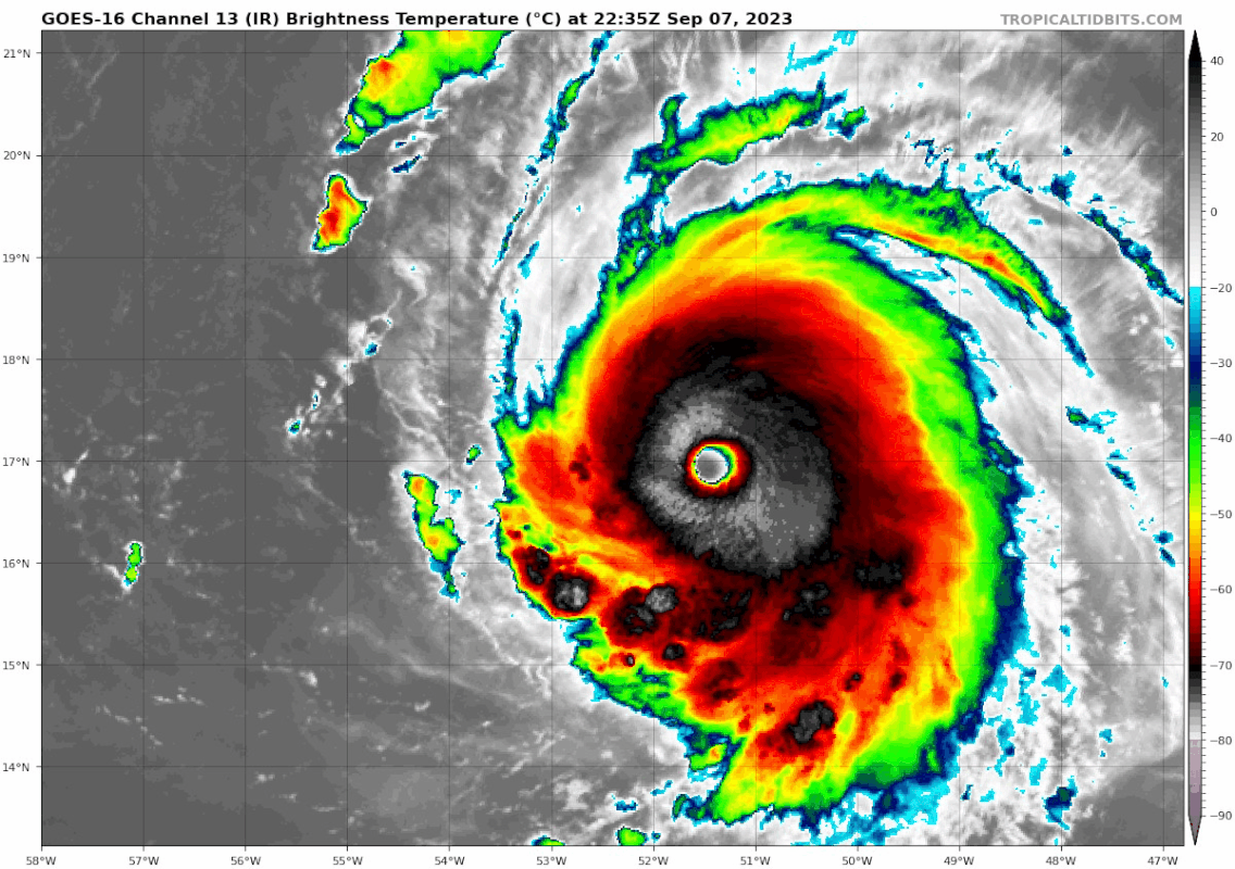
Eye is getting ragged on IR. Looks like an eyewall meld is starting. If it’s like Irma, we should see this continue to explode during tomorrow morning’s flights.
2 likes
Irene '11 Sandy '12 Hermine '16 5/15/2018 Derecho Fay '20 Isaias '20 Elsa '21 Henri '21 Ida '21
I am only a meteorology enthusiast who knows a decent amount about tropical cyclones. Look to the professional mets, the NHC, or your local weather office for the best information.
I am only a meteorology enthusiast who knows a decent amount about tropical cyclones. Look to the professional mets, the NHC, or your local weather office for the best information.

Re: ATL: LEE - Hurricane - Discussion
SconnieCane wrote:So, @GCANE you were saying it's still not perfectly positioned relative to the ULAC? And it's STILL intensifying like this?
Its crazy
2 likes
-
WalterWhite
- Category 1
- Posts: 342
- Joined: Fri Mar 17, 2023 5:53 pm
Re: ATL: LEE - Hurricane - Discussion
Honestly, what is up with the large discrepancy between the FL estimate (130 kt when adjusted by 90%) and the SMFR estimate (155 kt)?
0 likes
-
eastcoastFL
- Category 5
- Posts: 3996
- Age: 44
- Joined: Thu Apr 12, 2007 12:29 pm
- Location: Palm City, FL
Re: ATL: LEE - Hurricane - Discussion
aspen wrote:Eye is getting ragged on IR. Looks like an eyewall meld is starting. If it’s like Irma, we should see this continue to explode during tomorrow morning’s flights.
What is an eye meld?
1 likes
Personal Forecast Disclaimer:
The posts in this forum are NOT official forecast and should not be used as such. They are just the opinion of the poster and may or may not be backed by sound meteorological data. They are NOT endorsed by any professional institution or storm2k.org. For official information, please refer to the NHC and NWS products.
The posts in this forum are NOT official forecast and should not be used as such. They are just the opinion of the poster and may or may not be backed by sound meteorological data. They are NOT endorsed by any professional institution or storm2k.org. For official information, please refer to the NHC and NWS products.
-
ElectricStorm

- Category 5
- Posts: 5122
- Age: 24
- Joined: Tue Aug 13, 2019 11:23 pm
- Location: Skiatook, OK / Norman, OK
Re: ATL: LEE - Hurricane - Discussion
Eye drop supports 928mb, about a 5mb drop since last pass
0 likes
B.S Meteorology, University of Oklahoma '25
Please refer to the NHC, NWS, or SPC for official information.
Please refer to the NHC, NWS, or SPC for official information.
-
SconnieCane
- Category 5
- Posts: 1013
- Joined: Thu Aug 02, 2018 5:29 pm
- Location: Madison, WI
Re: ATL: LEE - Hurricane - Discussion
eastcoastFL wrote:aspen wrote:Eye is getting ragged on IR. Looks like an eyewall meld is starting. If it’s like Irma, we should see this continue to explode during tomorrow morning’s flights.
What is an eye meld?
Where a formative outer eyewall just kind of gets fused into the old inner one instead of constricting around it and gradually choking it off like in a standard EWRC. Thus the usual (sometimes temporary, sometimes not) decrease in maximum intensity normally seen with an EWRC is less pronounced or non-existent.
Last edited by SconnieCane on Thu Sep 07, 2023 8:50 pm, edited 1 time in total.
8 likes

Re: ATL: LEE - Hurricane - Discussion
EWRC question made prior reply is it can take up to 18 hours per what I understand. It is also my understanding the worry of an EWRC expands the distance of the wind field that many worry about. Although an EWRC usually causes a weakening while going through it, it is also my understanding that once complete, a favorable environment can cause it to grow even bigger and stronger once again. I am of the understanding it can go through more than one EWRC too. Am I correct in my understanding?
3 likes
-
Blown Away
- S2K Supporter
- Posts: 10253
- Joined: Wed May 26, 2004 6:17 am
Re: ATL: LEE - Hurricane - Discussion
aspen wrote:GCANE wrote:Looks like they got a secondary wind max outbound.
It’s really really close to the primary max, so I think we’re going to see an Irma-like eyewall meld, something that the hurricane models have been showing for a while. Just a lot earlier than they modeled.
Looks like a W wobble to.
Last edited by Blown Away on Thu Sep 07, 2023 8:51 pm, edited 1 time in total.
1 likes
Hurricane Eye Experience: David 79, Irene 99, Frances 04, Jeanne 04, Wilma 05… Hurricane Brush Experience: Andrew 92, Erin 95, Floyd 99, Matthew 16, Irma 17, Ian 22, Nicole 22…
-
SconnieCane
- Category 5
- Posts: 1013
- Joined: Thu Aug 02, 2018 5:29 pm
- Location: Madison, WI
Re: ATL: LEE - Hurricane - Discussion
lajga wrote:EWRC question made prior reply is it can take up to 18 hours per what I understand. It is also my understanding the worry of an EWRC expands the distance of the wind field that many worry about. Although an EWRC usually causes a weakening while going through it, it is also my understanding that once complete, a favorable environment can cause it to grow even bigger and stronger once again. I am of the understanding it can go through more than one EWRC too. Am I correct in my understanding?
Yes, that all sounds about right.
1 likes
Re: ATL: LEE - Hurricane - Discussion
This pass supports 145 kt/928 mbar. Easy Cat 5.
2 likes
Irene '11 Sandy '12 Hermine '16 5/15/2018 Derecho Fay '20 Isaias '20 Elsa '21 Henri '21 Ida '21
I am only a meteorology enthusiast who knows a decent amount about tropical cyclones. Look to the professional mets, the NHC, or your local weather office for the best information.
I am only a meteorology enthusiast who knows a decent amount about tropical cyclones. Look to the professional mets, the NHC, or your local weather office for the best information.
Re: ATL: LEE - Hurricane - Discussion
GCANE wrote:Eye drop
58% RH at 850 mb
Drying out fast
Can see the drying on all levels of WV Rapid Scan
0 likes
-
CrazyC83
- Professional-Met

- Posts: 34308
- Joined: Tue Mar 07, 2006 11:57 pm
- Location: Deep South, for the first time!
Re: ATL: LEE - Hurricane - Discussion
zzzh wrote:Drop 930mb 20kt
5 mb pressure drop in about 2 hours.
1 likes
-
CrazyC83
- Professional-Met
- Posts: 34308
- Joined: Tue Mar 07, 2006 11:57 pm
- Location: Deep South, for the first time!
Re: ATL: LEE - Hurricane - Discussion
It's a very warm eye too with a surface air temperature of 27.2°C in the eye of Lee.
What is the warmest eye ever in an Atlantic storm?
What is the warmest eye ever in an Atlantic storm?
1 likes
Who is online
Users browsing this forum: No registered users and 32 guests