
ATL: LEE - Post-Tropical - Discussion
Moderator: S2k Moderators
Re: ATL: LEE - Hurricane - Discussion
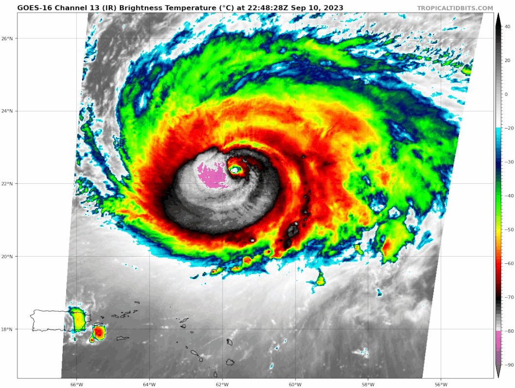
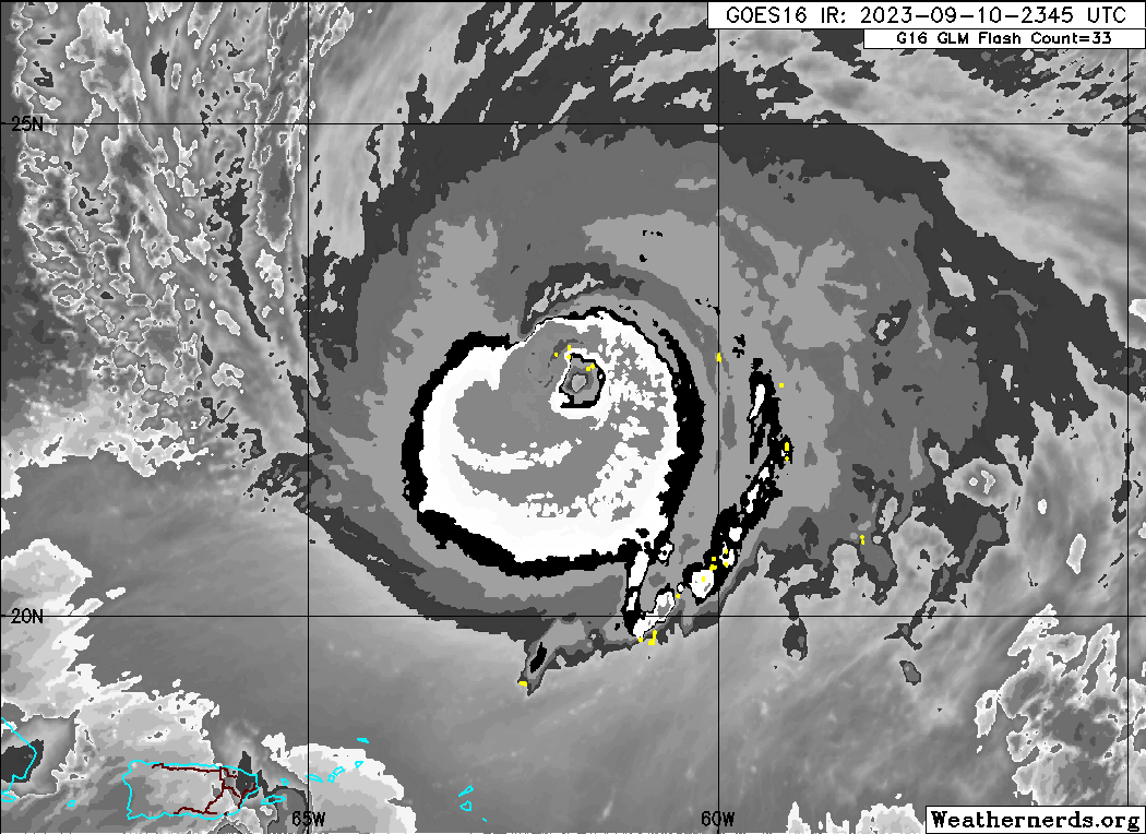
Huge blowup in the N eyewall:
1 likes
TC naming lists: retirements and intensity
Most aggressive Advisory #1's in North Atlantic (cr. kevin for starting the list)
Most aggressive Advisory #1's in North Atlantic (cr. kevin for starting the list)
-
Iceresistance

- Category 5

- Posts: 9579
- Age: 22
- Joined: Sat Oct 10, 2020 9:45 am
- Location: Tecumseh, OK/Norman, OK
Re: ATL: LEE - Hurricane - Discussion
Teban54 wrote:Huge blowup in the N eyewall:
https://i.postimg.cc/JnvvyRKS/goes16-ir-meso1.gif
Which has literally led to this drop

https://s11.gifyu.com/images/S4pB7.png
0 likes
Bill 2015 & Beta 2020
Winter 2020-2021
All observations are in Tecumseh, OK unless otherwise noted.
Winter posts are focused mainly for Oklahoma & Texas.
Take any of my forecasts with a grain of salt, refer to the NWS, SPC, and NHC for official information
Never say Never with weather! Because ANYTHING is possible!
Winter 2020-2021
All observations are in Tecumseh, OK unless otherwise noted.
Winter posts are focused mainly for Oklahoma & Texas.
Take any of my forecasts with a grain of salt, refer to the NWS, SPC, and NHC for official information
Never say Never with weather! Because ANYTHING is possible!

Re: ATL: LEE - Hurricane - Discussion
Dang this is looking good now. Solid pressure drop between passes and the eyewall drop supports 105-110 kt.
0 likes
Irene '11 Sandy '12 Hermine '16 5/15/2018 Derecho Fay '20 Isaias '20 Elsa '21 Henri '21 Ida '21
I am only a meteorology enthusiast who knows a decent amount about tropical cyclones. Look to the professional mets, the NHC, or your local weather office for the best information.
I am only a meteorology enthusiast who knows a decent amount about tropical cyclones. Look to the professional mets, the NHC, or your local weather office for the best information.
Re: ATL: LEE - Hurricane - Discussion
Drop has 952mb and 3kt. No pressure drop from last pass.
0 likes
Re: ATL: LEE - Hurricane - Discussion
Iceresistance wrote:Teban54 wrote:Huge blowup in the N eyewall:
https://i.postimg.cc/JnvvyRKS/goes16-ir-meso1.gif
Which has literally led to this drop
https://s11.gifyu.com/images/S4pB7.png
https://s11.gifyu.com/images/S4pB7.png
Weird mixing here.
0 likes
-
cheezyWXguy

- Category 5
- Posts: 6281
- Joined: Mon Feb 13, 2006 12:29 am
- Location: Dallas, TX
Re: ATL: LEE - Hurricane - Discussion
zzzh wrote:Drop has 952mb and 3kt. No pressure drop from last pass.
Strange that the extrapolated pressure could be spot on in the first pass but 4mb low in the second. Would expect there to be a consistent discrepancy between extrap and drop in each pass for a given flight
0 likes
Re: ATL: LEE - Hurricane - Discussion
Lee has a fat tire of convection surrounding its center...it's looking like a well aged and very durable hurricane and probably somewhat more shear resistant than the tightly wound top it was.
2 likes
-
cheezyWXguy
- Category 5
- Posts: 6281
- Joined: Mon Feb 13, 2006 12:29 am
- Location: Dallas, TX
Re: ATL: LEE - Hurricane - Discussion
One thing’s for sure, the windfield has significantly symmetrized. If this keeps up pressure and eventually winds will respond
0 likes
-
bob rulz
- Category 5
- Posts: 1711
- Age: 35
- Joined: Sat Jan 28, 2006 7:30 pm
- Location: Salt Lake City, Utah
Re: ATL: LEE - Hurricane - Discussion
Not sure why people were doubting Lee so much. We should know better than to write off a hurricane in this part of the basin at this time of year, that already has a history of RI.
4 likes
-
Iceresistance
- Category 5
- Posts: 9579
- Age: 22
- Joined: Sat Oct 10, 2020 9:45 am
- Location: Tecumseh, OK/Norman, OK
Re: ATL: LEE - Hurricane - Discussion
VDM #2 has a smaller eye
VORTEX DATA MESSAGE AL132023
A. 10/23:08:23Z
B. 22.30 deg N 061.80 deg W
C. 700 MB 2692 m
D. 952 mb
E. 055 deg 02 kt
F. CLOSED
G. C25
H. 95 kt
I. 006 deg 12 nm 23:05:38Z
J. 085 deg 107 kt
K. 004 deg 15 nm 23:04:48Z
L. 84 kt
M. 181 deg 16 nm 23:12:11Z
N. 264 deg 97 kt
O. 181 deg 18 nm 23:12:41Z
P. 11 C / 3064 m
Q. 17 C / 3062 m
R. NA C / NA
S. 12345 / 7
T. 0.01 / 2 nm
U. NOAA3 1413A LEE OB 16
MAX FL WIND 107 KT 004 / 15 NM 23:04:48Z
0 likes
Bill 2015 & Beta 2020
Winter 2020-2021
All observations are in Tecumseh, OK unless otherwise noted.
Winter posts are focused mainly for Oklahoma & Texas.
Take any of my forecasts with a grain of salt, refer to the NWS, SPC, and NHC for official information
Never say Never with weather! Because ANYTHING is possible!
Winter 2020-2021
All observations are in Tecumseh, OK unless otherwise noted.
Winter posts are focused mainly for Oklahoma & Texas.
Take any of my forecasts with a grain of salt, refer to the NWS, SPC, and NHC for official information
Never say Never with weather! Because ANYTHING is possible!
-
Iceresistance
- Category 5
- Posts: 9579
- Age: 22
- Joined: Sat Oct 10, 2020 9:45 am
- Location: Tecumseh, OK/Norman, OK
Re: ATL: LEE - Hurricane - Discussion
1 likes
Bill 2015 & Beta 2020
Winter 2020-2021
All observations are in Tecumseh, OK unless otherwise noted.
Winter posts are focused mainly for Oklahoma & Texas.
Take any of my forecasts with a grain of salt, refer to the NWS, SPC, and NHC for official information
Never say Never with weather! Because ANYTHING is possible!
Winter 2020-2021
All observations are in Tecumseh, OK unless otherwise noted.
Winter posts are focused mainly for Oklahoma & Texas.
Take any of my forecasts with a grain of salt, refer to the NWS, SPC, and NHC for official information
Never say Never with weather! Because ANYTHING is possible!
-
HurricaneBelle

- S2K Supporter

- Posts: 1209
- Joined: Sun Aug 27, 2006 6:12 pm
- Location: Clearwater, FL
Re: ATL: LEE - Hurricane - Discussion
bob rulz wrote:Not sure why people were doubting Lee so much. We should know better than to write off a hurricane in this part of the basin at this time of year, that already has a history of RI.
A lot of manic/depressive posters in here, every short-term trend gets extrapolated, and there's no mercy for a storm that doesn't provide the expected entertainment.
7 likes

Re: ATL: LEE - Hurricane - Discussion
Enjoyable day! The Dolphins get the "W", and Lee gets it's "I". Unfortunately, the storms slow motion is leading me to increasingly think that Maine or Nova Scotia could be looking at a strong Cat 1 or 2 landfall.
1 likes
Andy D
(For official information, please refer to the NHC and NWS products.)
(For official information, please refer to the NHC and NWS products.)
Re: ATL: LEE - Hurricane - Discussion
HurricaneBelle wrote:bob rulz wrote:Not sure why people were doubting Lee so much. We should know better than to write off a hurricane in this part of the basin at this time of year, that already has a history of RI.
A lot of manic/depressive posters in here, every short-term trend gets extrapolated, and there's no mercy for a storm that doesn't provide the expected entertainment.
It's just sleep depravation, they'll all be just fine. I've order each of them an asperin and an ERC, and instructed them to call you in the morning.
5 likes
Andy D
(For official information, please refer to the NHC and NWS products.)
(For official information, please refer to the NHC and NWS products.)
-
ElectricStorm

- Category 5
- Posts: 5140
- Age: 25
- Joined: Tue Aug 13, 2019 11:23 pm
- Location: Norman, OK
Re: ATL: LEE - Hurricane - Discussion
948mb extrap, NW quad supports 100-105kts so there could be some stronger winds in NE quad
0 likes
B.S Meteorology, University of Oklahoma '25
Please refer to the NHC, NWS, or SPC for official information.
Please refer to the NHC, NWS, or SPC for official information.
Re: ATL: LEE - Hurricane - Discussion
950/4 eye drop, nice and saturated still.
0 likes
Irene '11 Sandy '12 Hermine '16 5/15/2018 Derecho Fay '20 Isaias '20 Elsa '21 Henri '21 Ida '21
I am only a meteorology enthusiast who knows a decent amount about tropical cyclones. Look to the professional mets, the NHC, or your local weather office for the best information.
I am only a meteorology enthusiast who knows a decent amount about tropical cyclones. Look to the professional mets, the NHC, or your local weather office for the best information.
-
Iceresistance
- Category 5
- Posts: 9579
- Age: 22
- Joined: Sat Oct 10, 2020 9:45 am
- Location: Tecumseh, OK/Norman, OK
Re: ATL: LEE - Hurricane - Discussion
Raw ADT at a 7.1
Lee may become a Category 5 again
Lee may become a Category 5 again
1 likes
Bill 2015 & Beta 2020
Winter 2020-2021
All observations are in Tecumseh, OK unless otherwise noted.
Winter posts are focused mainly for Oklahoma & Texas.
Take any of my forecasts with a grain of salt, refer to the NWS, SPC, and NHC for official information
Never say Never with weather! Because ANYTHING is possible!
Winter 2020-2021
All observations are in Tecumseh, OK unless otherwise noted.
Winter posts are focused mainly for Oklahoma & Texas.
Take any of my forecasts with a grain of salt, refer to the NWS, SPC, and NHC for official information
Never say Never with weather! Because ANYTHING is possible!
-
cycloneye

- Admin

- Posts: 149275
- Age: 69
- Joined: Thu Oct 10, 2002 10:54 am
- Location: San Juan, Puerto Rico
Re: ATL: LEE - Hurricane - Discussion
SSD dvorak at 6.0.
A. 13L (LEE)
B. 11/0000Z
C. 22.4N
D. 61.7W
E. ONE/GOES-E
F. T6.0/6.0
G. IR/EIR/SWIR
H. REMARKS...OW EYE SURROUNDED BY W AND EMBEDDED IN B RESULTS IN A DT
OF 6.0 AFTER ADDING A 0.5 EYE ADJUSTMENT. MET AND PT ARE ALSO 6.0 BASED
ON RAPID 24HR DEVELOPMENT. THE FT IS BASED ON THE DT.
I. ADDL POSITIONS
NIL
...CLARK
B. 11/0000Z
C. 22.4N
D. 61.7W
E. ONE/GOES-E
F. T6.0/6.0
G. IR/EIR/SWIR
H. REMARKS...OW EYE SURROUNDED BY W AND EMBEDDED IN B RESULTS IN A DT
OF 6.0 AFTER ADDING A 0.5 EYE ADJUSTMENT. MET AND PT ARE ALSO 6.0 BASED
ON RAPID 24HR DEVELOPMENT. THE FT IS BASED ON THE DT.
I. ADDL POSITIONS
NIL
...CLARK
1 likes
Visit the Caribbean-Central America Weather Thread where you can find at first post web cams,radars
and observations from Caribbean basin members Click Here
and observations from Caribbean basin members Click Here

Re: ATL: LEE - Hurricane - Discussion
Starting to get interesting to watch again.
Are they calling for re intensification to a cat 5?
Are they calling for re intensification to a cat 5?
1 likes
Re: ATL: LEE - Hurricane - Discussion
NW eyewall drop has 132 kt winds at the 942mb level.
0 likes
Irene '11 Sandy '12 Hermine '16 5/15/2018 Derecho Fay '20 Isaias '20 Elsa '21 Henri '21 Ida '21
I am only a meteorology enthusiast who knows a decent amount about tropical cyclones. Look to the professional mets, the NHC, or your local weather office for the best information.
I am only a meteorology enthusiast who knows a decent amount about tropical cyclones. Look to the professional mets, the NHC, or your local weather office for the best information.
Who is online
Users browsing this forum: Google Adsense [Bot] and 76 guests