ATL: IDALIA - Post-Tropical - Discussion
Moderator: S2k Moderators

Re: ATL: IDALIA - Hurricane - Discussion
I have a feeling that we’re going to end up with idalia having the pressure of a mid to high category four, but the wind speeds of a high three or low four because the winds won’t have enough time to catch up before landfall.
1 likes
-
AJC3

- Admin

- Posts: 4153
- Age: 62
- Joined: Tue Aug 31, 2004 7:04 pm
- Location: Ballston Spa, New York
- Contact:
Re: ATL: IDALIA - Hurricane - Discussion
Clearcloudz wrote:Eric Burris (Remember his name because he has been calling this since yesterday.)
https://twitter.com/EricBurrisWESH/status/1696480931358310435
Anyone have the tech savvy to plot the recon center fixes on top of the corresponding Key West Radar imagery (with both geolocated for accuracy)? The beam height out at that distance is >25kft, and there could still be a small amount of eastward tilt with height.
4 likes
-
InfernoFlameCat

- Category 5

- Posts: 2127
- Age: 22
- Joined: Mon Dec 14, 2020 10:52 am
- Location: Buford, GA
Re: ATL: IDALIA - Hurricane - Discussion
Hopefully this thing is organizing more slowly than we think. Let’s pray for a below major hurricane landfall.
2 likes
I am by no means a professional. DO NOT look at my forecasts for official information or make decisions based on what I post.
Goal: to become a registered expert over tropical and subtropical cyclones.
Goal: to become a registered expert over tropical and subtropical cyclones.

Re: ATL: IDALIA - Hurricane - Discussion
Fancy1002 wrote:I have a feeling that we’re going to end up with idalia having the pressure of a mid to high category four, but the wind speeds of a high three or low four because the winds won’t have enough time to catch up before landfall.
Keep in mind that Idalia comes from a monsoonal trough so surrounding environmental pressures were already well below average, so its pressure is more of what you find in the W PAC systems.
3 likes
Re: ATL: IDALIA - Hurricane - Discussion
HurricaneEnzo wrote:Using radar loops it looks pretty much due North to me. Maybe a slight east jog but I'm not convinced it wasn't just a wobble yet. It's gonna wobble around a bit while it's getting its core together. A long ways to go but I don't see this becoming significantly east of the NHCs track.
Also, never use satellite to determine track when you have radar available. It can be very misleading. And look at overall motion over an extended period not every wobble.
I remember in 2020 NHC had hurricane Isaias coming in around the SC/NC border. All you saw on twitter was these wobble watchers proclaiming it was going to go way east potentially to Jacksonville NC. Well, that didn't happen. This is obviously a completely different situation just saying the NHC is the best in the game always go with them first.
This is just my opinion though.
It isnt really surprising. Euro ensembles predicted a further right track with a higher intensity storm. So the wobble in fact could be a more slight east motion. That can mean all the difference for Tampa Bay wind and surge wise.
Last edited by caneman on Tue Aug 29, 2023 7:43 am, edited 1 time in total.
1 likes
-
ScottNAtlanta

- Category 5
- Posts: 2535
- Joined: Sat May 25, 2013 3:11 pm
- Location: Atlanta, GA
Re: ATL: IDALIA - Hurricane - Discussion
Dropsonde 84kts at 925mb...that's about 2000 feet (1995 ft)
4 likes
The posts in this forum are NOT official forecast and should not be used as such. They are just the opinion of the poster and may or may not be backed by sound meteorological data. They are NOT endorsed by any professional institution or storm2k.org. For official information, please refer to the NHC and NWS products.
-
SFLcane

- S2K Supporter

- Posts: 10281
- Age: 48
- Joined: Sat Jun 05, 2010 1:44 pm
- Location: Lake Worth Florida
Re: ATL: IDALIA - Hurricane - Discussion
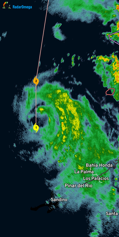
NDG wrote:No way Idalia is moving straight due north this morning. I wouldn't rule out landfall closer to Cedar Key than shown by the models.
https://i.imgur.com/LBxCqTR.gif
It’s right on the nhc track convection can be deceiving.
Last edited by SFLcane on Tue Aug 29, 2023 7:46 am, edited 1 time in total.
2 likes
-
Kingarabian

- S2K Supporter
- Posts: 16338
- Joined: Sat Aug 08, 2009 3:06 am
- Location: Honolulu, Hawaii
Re: ATL: IDALIA - Hurricane - Discussion
Running about 10mb lower and 10kts higher winds vs Dvorak estimates.
2 likes
RIP Kobe Bryant
-
Extratropical94

- Professional-Met

- Posts: 3545
- Age: 31
- Joined: Wed Oct 20, 2010 6:36 am
- Location: Hamburg, Germany
- Contact:
Re: ATL: IDALIA - Hurricane - Discussion
00979 23512
979 mb 12 kt center splash, pressure pretty much unchanged from last pass
979 mb 12 kt center splash, pressure pretty much unchanged from last pass
2 likes
54° 11' 59'' N, 9° 9' 20'' E
Boomer Sooner!
Go Broncos! Go Cards!
Clinching counties, one at a time: https://mob-rule.com/user-gifs/USA/xtrp94.gif
- Daniel
Boomer Sooner!
Go Broncos! Go Cards!
Clinching counties, one at a time: https://mob-rule.com/user-gifs/USA/xtrp94.gif
- Daniel
-
USTropics
- Professional-Met
- Posts: 2736
- Joined: Sun Aug 12, 2007 3:45 am
- Location: Florida State University
Re: ATL: IDALIA - Hurricane - Discussion
AJC3 wrote:Clearcloudz wrote:Eric Burris (Remember his name because he has been calling this since yesterday.)
https://twitter.com/EricBurrisWESH/status/1696480931358310435
Anyone have the tech savvy to plot the recon center fixes on top of the corresponding Key West Radar imagery (with both geolocated for accuracy)? The beam height out at that distance is >25kft, and there could still be a small amount of eastward tilt with height.
You can kind of do this with Cesium at TropicalAtlantic (http://tropicalatlantic.com/recon/recon ... ing=cesium), just turn on the two radar layers:


7 likes
-
jlauderdal
- S2K Supporter
- Posts: 7240
- Joined: Wed May 19, 2004 5:46 am
- Location: NE Fort Lauderdale
- Contact:
Re: ATL: IDALIA - Hurricane - Discussion
SFLcane wrote:NDG wrote:No way Idalia is moving straight due north this morning. I wouldn't rule out landfall closer to Cedar Key than shown by the models.
https://i.imgur.com/LBxCqTR.gif
It’s right on the nhc track convection can be deceiving.
https://i.postimg.cc/6qkNPGy6/IMG-7531.jpg
recon has it east of the track
4 likes
Re: ATL: IDALIA - Hurricane - Discussion
AJC3 wrote:Clearcloudz wrote:Eric Burris (Remember his name because he has been calling this since yesterday.)
https://twitter.com/EricBurrisWESH/status/1696480931358310435
Anyone have the tech savvy to plot the recon center fixes on top of the corresponding Key West Radar imagery (with both geolocated for accuracy)? The beam height out at that distance is >25kft, and there could still be a small amount of eastward tilt with height.
I have the cross hair at 23.95N 84.75W where the recon's extrap found the lowest pressure.

4 likes
Re: ATL: IDALIA - Hurricane - Discussion
SFLcane wrote:NDG wrote:No way Idalia is moving straight due north this morning. I wouldn't rule out landfall closer to Cedar Key than shown by the models.
https://i.imgur.com/LBxCqTR.gif
It’s right on the nhc track convection can be deceiving.
https://i.postimg.cc/6qkNPGy6/IMG-7531.jpg
It's verified east of track already .3 from the 5 am update
Last edited by caneman on Tue Aug 29, 2023 7:49 am, edited 1 time in total.
1 likes
-
tolakram
- Admin
- Posts: 20174
- Age: 62
- Joined: Sun Aug 27, 2006 8:23 pm
- Location: Florence, KY (name is Mark)
Re: ATL: IDALIA - Hurricane - Discussion
How many gulf landfalling storms have been underestimated in the last 5 years? I read some overnight posts once again thinking this won't be as strong as forecast.  Fortunately I think most people on here are taking this storm very seriously, especially after last year. We can always hope Idalia will end the trend of hurricanes strengthening all the way until landfall, but I would not bet on it.
11 likes
M a r k
- - - - -
Join us in chat: Storm2K Chatroom Invite. Android and IOS apps also available.
The posts in this forum are NOT official forecasts and should not be used as such. Posts are NOT endorsed by any professional institution or STORM2K.org. For official information and forecasts, please refer to NHC and NWS products.
-
ScottNAtlanta
- Category 5
- Posts: 2535
- Joined: Sat May 25, 2013 3:11 pm
- Location: Atlanta, GA
Re: ATL: IDALIA - Hurricane - Discussion
MESOCYCLONE INDICATED ON RADAR - 360 / 10NM FROM CTR
What does that mean?
What does that mean?
2 likes
The posts in this forum are NOT official forecast and should not be used as such. They are just the opinion of the poster and may or may not be backed by sound meteorological data. They are NOT endorsed by any professional institution or storm2k.org. For official information, please refer to the NHC and NWS products.

Re: ATL: IDALIA - Hurricane - Discussion
So since the two passes had the same pressure and somewhat similar spread of wind field, what exactly was Idalia doing between the passes? Not that I'm impatient...
0 likes
TC naming lists: retirements and intensity
Most aggressive Advisory #1's in North Atlantic (cr. kevin for starting the list)
Most aggressive Advisory #1's in North Atlantic (cr. kevin for starting the list)
-
jlauderdal
- S2K Supporter
- Posts: 7240
- Joined: Wed May 19, 2004 5:46 am
- Location: NE Fort Lauderdale
- Contact:
Re: ATL: IDALIA - Hurricane - Discussion
caneman wrote:SFLcane wrote:NDG wrote:No way Idalia is moving straight due north this morning. I wouldn't rule out landfall closer to Cedar Key than shown by the models.
https://i.imgur.com/LBxCqTR.gif
It’s right on the nhc track convection can be deceiving.
https://i.postimg.cc/6qkNPGy6/IMG-7531.jpg
It's verified east of track already .3 from the 5 am update
SFlcane knows his stuff; he gets a mulligan on this one. I have had plenty of mulligans and tabasco sauce with all the crow over the years, it happens....
4 likes
-
Extratropical94
- Professional-Met
- Posts: 3545
- Age: 31
- Joined: Wed Oct 20, 2010 6:36 am
- Location: Hamburg, Germany
- Contact:
Re: ATL: IDALIA - Hurricane - Discussion
ScottNAtlanta wrote:MESOCYCLONE INDICATED ON RADAR - 360 / 10NM FROM CTR
What does that mean?
They noticed a rotating supercell 10 nautical miles north of Idalia's center on their radar. A good indicator that Idalia's circulation is capable of spawning tornadoes
6 likes
54° 11' 59'' N, 9° 9' 20'' E
Boomer Sooner!
Go Broncos! Go Cards!
Clinching counties, one at a time: https://mob-rule.com/user-gifs/USA/xtrp94.gif
- Daniel
Boomer Sooner!
Go Broncos! Go Cards!
Clinching counties, one at a time: https://mob-rule.com/user-gifs/USA/xtrp94.gif
- Daniel
-
AJC3
- Admin
- Posts: 4153
- Age: 62
- Joined: Tue Aug 31, 2004 7:04 pm
- Location: Ballston Spa, New York
- Contact:
Re: ATL: IDALIA - Hurricane - Discussion
ScottNAtlanta wrote:MESOCYCLONE INDICATED ON RADAR - 360 / 10NM FROM CTR
What does that mean?
Basically it's a rotating supercell thunderstorm embedded in the eyewall. Happens somewhat often in strong/RI-ing hurricanes.
7 likes

Re: ATL: IDALIA - Hurricane - Discussion
Latest center fix from Miss Piggy
Moving due north.
Still 14 miles east of forecast track
Moving due north.
Still 14 miles east of forecast track
1 likes
Who is online
Users browsing this forum: No registered users and 8 guests