EP, 94, 2023071100, , BEST, 0, 107N, 1014W, 25, 1008, DB
CPAC: CALVIN - Post-Tropical - Discussion
Moderator: S2k Moderators
-
cycloneye

- Admin

- Posts: 149697
- Age: 69
- Joined: Thu Oct 10, 2002 10:54 am
- Location: San Juan, Puerto Rico
Re: EPAC: INVEST 94E - Discussion
0 likes
Visit the Caribbean-Central America Weather Thread where you can find at first post web cams,radars
and observations from Caribbean basin members Click Here
and observations from Caribbean basin members Click Here
-
cycloneye
- Admin
- Posts: 149697
- Age: 69
- Joined: Thu Oct 10, 2002 10:54 am
- Location: San Juan, Puerto Rico
Re: EPAC: INVEST 94E - Discussion
Almost cat 3 with little shear after 36 hours.
* GFS version *
* EAST PACIFIC 2023 SHIPS INTENSITY FORECAST *
* IR SAT DATA AVAILABLE, OHC AVAILABLE *
* INVEST EP942023 07/11/23 00 UTC *
TIME (HR) 0 6 12 18 24 36 48 60 72 84 96 108 120 132 144 156 168
V (KT) NO LAND 25 26 28 30 33 42 54 67 80 87 91 94 92 88 85 83 79
V (KT) LAND 25 26 28 30 33 42 54 67 80 87 91 94 92 88 85 83 79
V (KT) LGEM 25 27 28 29 29 31 35 39 45 53 61 69 73 72 66 60 55
Storm Type TROP TROP TROP TROP TROP TROP TROP TROP TROP TROP TROP TROP TROP TROP TROP TROP TROP
SHEAR (KT) 16 18 20 14 11 9 2 5 2 4 5 6 4 4 4 9 12
SHEAR ADJ (KT) 6 0 3 5 7 5 2 2 1 2 -2 -3 -1 0 1 -3 -6
SHEAR DIR 7 12 15 9 12 67 307 17 353 350 36 60 35 274 281 264 247
SST (C) 29.7 30.0 29.6 28.9 28.6 28.1 28.4 28.0 27.4 26.3 27.1 27.1 26.1 25.1 24.3 24.0 23.8
POT. INT. (KT) 163 167 163 155 152 148 151 147 141 129 135 134 125 115 107 104 103
200 MB T (C) -51.9 -52.1 -52.2 -52.2 -52.0 -52.5 -51.9 -52.2 -52.0 -52.1 -51.8 -52.0 -51.7 -52.3 -52.0 -52.3 -52.3
200 MB VXT (C) -0.3 -0.3 -0.3 -0.3 -0.2 0.3 0.2 0.5 0.3 0.5 0.4 0.4 0.5 0.9 1.0 0.8 0.7
TH_E DEV (C) 6 6 6 6 6 6 5 3 3 3 3 4 3 3 2 1 1
700-500 MB RH 75 74 77 78 80 84 81 82 76 74 70 67 63 62 62 62 54
MODEL VTX (KT) 8 10 10 12 13 15 18 20 23 25 26 27 25 23 22 20 17
850 MB ENV VOR -22 -24 -13 -2 -4 3 1 16 26 31 25 15 4 -6 -19 -19 -8
200 MB DIV 92 69 64 57 75 80 69 22 35 16 12 -2 10 -4 0 -10 -17
700-850 TADV 9 5 4 7 4 3 -2 -4 -1 -5 -6 -2 2 2 7 4 4
LAND (KM) 692 701 706 709 721 819 1019 1178 1462 1761 2027 2190 2277 2334 2120 1830 1497
LAT (DEG N) 10.7 11.1 11.7 12.3 12.8 13.7 14.3 14.7 14.6 13.9 13.2 12.9 13.5 xx.x xx.x xx.x xx.x
LONG(DEG W) 101.4 102.7 104.1 105.5 106.9 109.9 113.3 117.1 120.9 124.3 127.0 128.9 130.7 xxx.x xxx.x xxx.x xxx.x
STM SPEED (KT) 13 14 15 15 15 16 18 19 18 16 11 9 10 13 14 15 16
HEAT CONTENT 26 32 34 18 14 11 21 7 5 0 3 3 0 0 0 0 0
FORECAST TRACK FROM TABM INITIAL HEADING/SPEED (DEG/KT):280/ 12 CX,CY: -11/ 2
T-12 MAX WIND: 20 PRESSURE OF STEERING LEVEL (MB): 556 (MEAN=588)
GOES IR BRIGHTNESS TEMP. STD DEV. 50-200 KM RAD: 23.6 (MEAN=14.5)
% GOES IR PIXELS WITH T < -20 C 50-200 KM RAD: 59.0 (MEAN=65.0)
PRELIM RI PROB (DV .GE. 35 KT IN 36 HR): 10.3
INDIVIDUAL CONTRIBUTIONS TO INTENSITY CHANGE
6 12 18 24 36 48 60 72 84 96 108 120 132 144 156 168
--------------------------------------------------------------------------------------------
SAMPLE MEAN CHANGE 0. 1. 1. 1. 1. 2. 2. 1. 1. -0. -1. -1. -2. -3. -3. -4.
SST POTENTIAL -0. -0. 1. 3. 10. 20. 29. 37. 41. 45. 48. 50. 50. 49. 48. 46.
VERTICAL SHEAR MAG 0. 1. 1. 1. 0. -0. -1. -1. 1. 1. 2. 4. 6. 7. 8. 10.
VERTICAL SHEAR ADJ -0. -1. -1. -2. -3. -3. -3. -2. -1. -1. -0. -0. -0. -0. -0. -0.
VERTICAL SHEAR DIR 0. 0. 1. 1. 2. 3. 3. 3. 3. 3. 4. 4. 2. 1. 0. 0.
PERSISTENCE 1. 1. 1. 1. 1. 1. 1. 1. 1. 1. 1. 1. 1. 1. 1. 1.
200/250 MB TEMP. -0. -0. -0. -1. -1. -2. -2. -2. -3. -3. -3. -3. -2. -0. 0. 0.
THETA_E EXCESS -0. -0. -0. -0. -0. -0. -1. -2. -3. -3. -3. -3. -4. -4. -4. -4.
700-500 MB RH 0. 0. 0. 1. 1. 2. 2. 2. 2. 2. 1. 1. 1. 1. 1. 2.
MODEL VTX TENDENCY 0. 1. 3. 3. 5. 9. 14. 20. 23. 24. 24. 19. 15. 12. 9. 7.
850 MB ENV VORTICITY -0. -0. -0. -0. -0. -0. 0. 0. 0. 0. 0. 0. 0. 0. 0. 0.
200 MB DIVERGENCE 0. 0. 0. 0. 1. 1. 1. 1. 1. 1. 1. 0. 0. -0. 0. 0.
850-700 T ADVEC -0. -0. -0. -0. -0. -0. -0. -0. -0. -0. -0. 0. 0. 0. 0. 1.
ZONAL STORM MOTION 0. -0. -0. -0. 0. 0. 0. -0. -0. -0. -0. -0. -1. -1. -1. -2.
STEERING LEVEL PRES -0. -0. -0. -0. -0. -0. -0. -0. -0. -0. -1. -1. -1. -1. -0. -0.
DAYS FROM CLIM. PEAK -0. -0. -0. -0. -0. -0. -0. -1. -1. -2. -2. -2. -2. -3. -3. -4.
GOES PREDICTORS 0. 0. 0. -0. -0. -1. -2. -2. -3. -3. -4. -4. -4. -4. -3. -4.
OCEAN HEAT CONTENT -0. -0. -0. -0. -0. 0. 0. -0. 0. 0. 0. 0. 0. 1. 2. 2.
RI POTENTIAL 0. -0. -0. -0. -1. -1. -1. -0. 0. 1. 2. 2. 2. 2. 2. 2.
--------------------------------------------------------------------------------------------
TOTAL CHANGE 1. 3. 6. 8. 17. 29. 42. 55. 62. 66. 69. 67. 63. 60. 58. 54.
CURRENT MAX WIND (KT): 25. LAT, LON: 10.7 101.4
** 2023 E. PACIFIC RI INDEX EP942023 INVEST 07/11/23 00 UTC **
(SHIPS-RII PREDICTOR TABLE for 30 KT OR MORE MAXIMUM WIND INCREASE IN NEXT 24-h)
Predictor Value RI Predictor Range Scaled Value(0-1) % Contribution
POT = MPI-VMAX (KT) : 135.1 36.9 to 148.5 0.88 7.6
12 HR PERSISTENCE (KT) : 5.0 -22.0 to 44.0 0.41 3.0
MULTI-LAYER SHEAR (KT) : 29.4 30.9 to 7.7 0.07 0.4
BL DRY-AIR FLUX (W/M2) : 36.0 816.2 to -81.4 0.87 -5.8
D200 (10**7s-1) : 71.4 -33.0 to 159.5 0.54 2.8
MAXIMUM WIND (KT) : 25.0 22.5 to 132.0 0.07 0.4
STD DEV OF IR BR TEMP : 23.6 37.8 to 2.1 0.40 1.6
HEAT CONTENT (KJ/CM2) : 24.8 2.7 to 103.4 0.22 0.6
%area of TPW <45 mm upshear : 0.0 49.8 to 0.0 1.00 1.6
2nd PC OF IR BR TEMP : -1.3 2.2 to -2.3 0.78 0.1
SHIPS Prob RI for 20kt/ 12hr RI threshold= 0% is 0.0 times climatological mean ( 6.3%)
SHIPS Prob RI for 25kt/ 24hr RI threshold= 15% is 1.2 times climatological mean (12.5%)
SHIPS Prob RI for 30kt/ 24hr RI threshold= 12% is 1.4 times climatological mean ( 8.6%)
SHIPS Prob RI for 35kt/ 24hr RI threshold= 0% is 0.0 times climatological mean ( 6.2%)
SHIPS Prob RI for 40kt/ 24hr RI threshold= 0% is 0.0 times climatological mean ( 4.2%)
SHIPS Prob RI for 45kt/ 36hr RI threshold= 14% is 2.1 times climatological mean ( 6.7%)
SHIPS Prob RI for 55kt/ 48hr RI threshold= 14% is 2.3 times climatological mean ( 5.9%)
SHIPS Prob RI for 65kt/ 72hr RI threshold= 0% is 0.0 times climatological mean ( 4.7%)
Matrix of RI probabilities
------------------------------------------------------------------------------
RI (kt / h) | 20/12 | 25/24 | 30/24 | 35/24 | 40/24 | 45/36 | 55/48 |65/72
------------------------------------------------------------------------------
SHIPS-RII: 0.0% 14.6% 12.3% 0.0% 0.0% 14.2% 13.8% 0.0%
Logistic: 0.5% 5.8% 2.1% 0.9% 0.1% 2.7% 6.9% 19.9%
Bayesian: 0.2% 1.6% 0.2% 0.0% 0.0% 0.1% 4.0% 1.3%
Consensus: 0.2% 7.4% 4.8% 0.3% 0.0% 5.7% 8.2% 7.1%
DTOPS: 1.0% 7.0% 3.0% 1.0% 1.0% 6.0% 7.0% 14.0%
## ANNULAR HURRICANE INDEX (AHI) EP942023 INVEST 07/11/23 00 UTC ##
## STORM NOT ANNULAR, SCREENING STEP FAILED, NPASS=3 NFAIL=4 ##
## AHI= 0 (AHI OF 100 IS BEST FIT TO ANN. STRUC., 1 IS MARGINAL, 0 IS NOT ANNULAR) ##
0 likes
Visit the Caribbean-Central America Weather Thread where you can find at first post web cams,radars
and observations from Caribbean basin members Click Here
and observations from Caribbean basin members Click Here

Re: EPAC: INVEST 94E - Discussion
Not that well organized yet, circulation still looks to be broad.
No deep convection right near the latest best track position by the NHC.

No deep convection right near the latest best track position by the NHC.
0 likes
-
Blown Away

- S2K Supporter

- Posts: 10253
- Joined: Wed May 26, 2004 6:17 am
Re: EPAC: INVEST 94E - Discussion
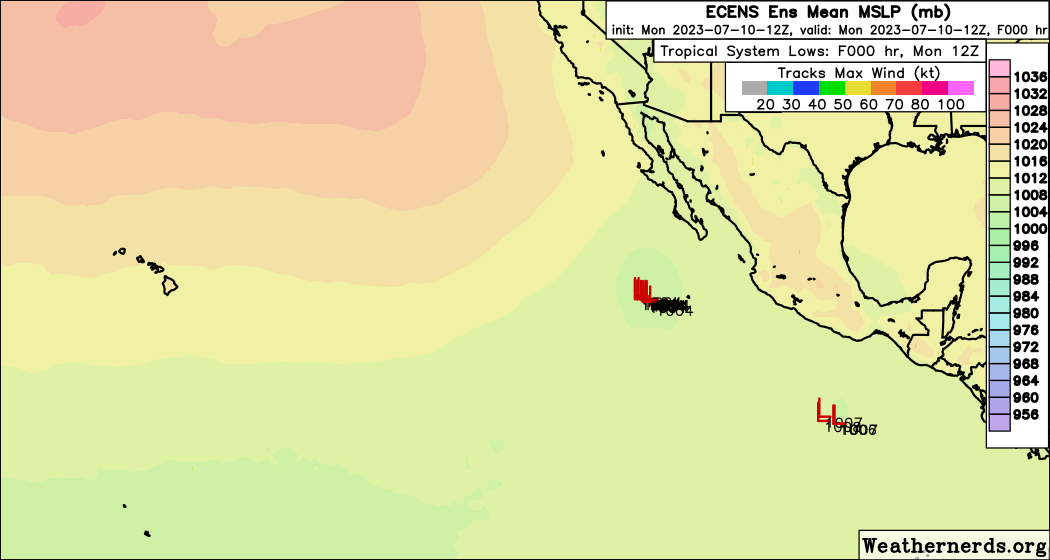
12z ECENS showing TS in/near Hawaii…
0 likes
Hurricane Eye Experience: David 79, Irene 99, Frances 04, Jeanne 04, Wilma 05… Hurricane Brush Experience: Andrew 92, Erin 95, Floyd 99, Matthew 16, Irma 17, Ian 22, Nicole 22…
-
Kingarabian

- S2K Supporter
- Posts: 16377
- Joined: Sat Aug 08, 2009 3:06 am
- Location: Honolulu, Hawaii
Re: EPAC: INVEST 94E - Discussion
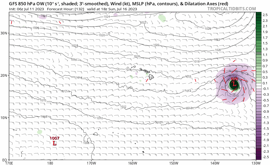
Teban54 wrote:So the GFS was initially aggressive with this invest becoming a long-track major, then went quiet since 0z 7/8 to the point of almost not showing a hurricane... And now there are two runs in a row with a major again.
Any idea why?
https://i.postimg.cc/RV9bYQLd/gfs-mslp-pcpn-epac-fh102-trend-1.gif
Steering pattern I would say. Weaker runs showed it tracking into that large area of stratocumulus sooner.
0 likes
RIP Kobe Bryant
-
Kingarabian
- S2K Supporter
- Posts: 16377
- Joined: Sat Aug 08, 2009 3:06 am
- Location: Honolulu, Hawaii
Re: EPAC: INVEST 94E - Discussion
Blown Away wrote:[url]https://i.postimg.cc/G2rB8wSw/67991859.gif [/url]
12z ECENS showing TS in/near Hawaii…
I think it'll be minimal impacts from this system if any. Likely passing showers and some gusts. Most ensembles keep this very weak close to Hawaii.
0 likes
RIP Kobe Bryant
-
cycloneye
- Admin
- Posts: 149697
- Age: 69
- Joined: Thu Oct 10, 2002 10:54 am
- Location: San Juan, Puerto Rico
Re: EPAC: INVEST 94E - Discussion
https://twitter.com/Yellow_Evan/status/1678589332247154690
Text of tweet.
Text of tweet.
@Yellow_Evan
Invest #94E has been lacking in convective organization, with convection elongated northeast to southwest, although recent frames suggest more convective curvature. Latest ASCAT and microwave imagery suggests a closed surface circulation exists, however.
Invest #94E has been lacking in convective organization, with convection elongated northeast to southwest, although recent frames suggest more convective curvature. Latest ASCAT and microwave imagery suggests a closed surface circulation exists, however.
0 likes
Visit the Caribbean-Central America Weather Thread where you can find at first post web cams,radars
and observations from Caribbean basin members Click Here
and observations from Caribbean basin members Click Here
-
Kingarabian
- S2K Supporter
- Posts: 16377
- Joined: Sat Aug 08, 2009 3:06 am
- Location: Honolulu, Hawaii
Re: EPAC: INVEST 94E - Discussion
Probably will hold its current structure for the next 24-48 hours. CMISS shows almost 30kts of shear ahead of it and models keep that shear moderate.
1 likes
RIP Kobe Bryant
-
Yellow Evan

- Professional-Met

- Posts: 16257
- Age: 27
- Joined: Fri Jul 15, 2011 12:48 pm
- Location: Henderson, Nevada/Honolulu, HI
- Contact:
Re: EPAC: INVEST 94E - Discussion
Last 2 ECMWF runs have trended higher with shear in the 3-4 day time frame.
1 likes
-
Sciencerocks
- Category 5

- Posts: 10193
- Age: 40
- Joined: Thu Jul 06, 2017 1:51 am

-
Yellow Evan
- Professional-Met
- Posts: 16257
- Age: 27
- Joined: Fri Jul 15, 2011 12:48 pm
- Location: Henderson, Nevada/Honolulu, HI
- Contact:
Re: EPAC: INVEST 94E - Discussion

Personally think this is adequate but NHC might not bite until 15z.
0 likes
-
Yellow Evan
- Professional-Met
- Posts: 16257
- Age: 27
- Joined: Fri Jul 15, 2011 12:48 pm
- Location: Henderson, Nevada/Honolulu, HI
- Contact:

-
Sciencerocks
- Category 5
- Posts: 10193
- Age: 40
- Joined: Thu Jul 06, 2017 1:51 am
Re: EPAC: INVEST 94E - Discussion
Tropical Weather Outlook
NWS National Hurricane Center Miami FL
1100 PM PDT Mon Jul 10 2023
For the eastern North Pacific...east of 140 degrees west longitude:
Offshore of Southern Mexico (EP94):
Shower and thunderstorm activity continues to become better
organized in association with an area of low pressure located a few
hundred miles south of the southern coast of Mexico. Recent
satellite-derived wind data indicates that the system does not yet
have a well-defined center, but is producing winds near
tropical-storm-force to its west. Environmental conditions appear
conducive for additional development, and a tropical depression or
tropical storm is expected to form during the next day or two. The
system is expected to move westward to west-northwestward at 15 to
20 mph over the next several days, remaining well offshore of the
coast of Mexico.
* Formation chance through 48 hours...high...90 percent.
* Formation chance through 7 days...high...90 percent.
$$
Forecaster Papin
0 likes
-
Yellow Evan
- Professional-Met
- Posts: 16257
- Age: 27
- Joined: Fri Jul 15, 2011 12:48 pm
- Location: Henderson, Nevada/Honolulu, HI
- Contact:
Re: EPAC: INVEST 94E - Discussion
Kingarabian wrote:Probably will hold its current structure for the next 24-48 hours. CMISS shows almost 30kts of shear ahead of it and models keep that shear moderate.
Now that these are accessible, it is probably best to use forecast AA soundings for shear from GFS/ECMWF rather than using CMISS maps and assuming they will stay constant over time.
0 likes
Re: EPAC: INVEST 94E - Discussion
0z Euro makes more sense to me of not much strengthening over the next 48- hs before maybe conditions get better but then getting battered by westerly windshear as it gets closer to Hawaii, unlike the GFS.

0 likes
Re: EPAC: INVEST 94E - Discussion
Yellow Evan wrote:https://media.discordapp.net/attachments/733552978572869632/1128196681716994058/20230711.png
Personally think this is adequate but NHC might not bite until 15z.
ASCAT C an hour later didn't make it look that well organized.

0 likes
-
Blown Away
- S2K Supporter
- Posts: 10253
- Joined: Wed May 26, 2004 6:17 am
Re: EPAC: INVEST 94E - Discussion
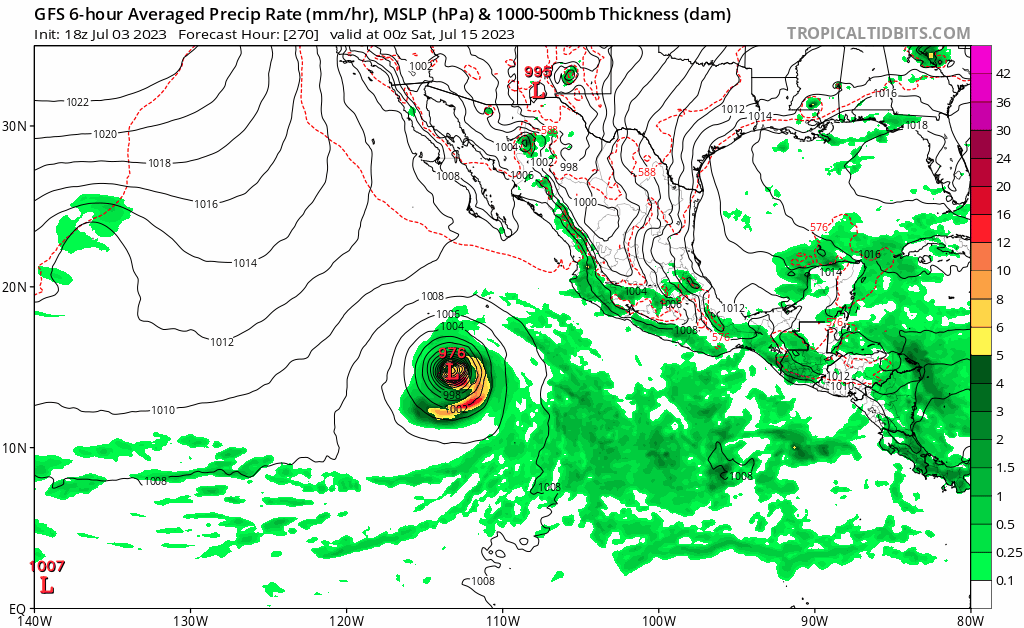
GFS still liking a TS/Cane over/near Hawaii...
0 likes
Hurricane Eye Experience: David 79, Irene 99, Frances 04, Jeanne 04, Wilma 05… Hurricane Brush Experience: Andrew 92, Erin 95, Floyd 99, Matthew 16, Irma 17, Ian 22, Nicole 22…
-
Sciencerocks
- Category 5
- Posts: 10193
- Age: 40
- Joined: Thu Jul 06, 2017 1:51 am

Re: EPAC: INVEST 94E - Discussion
Throw the GFS's solution, at least in the short term, out the window.
Convection keeps racing away from its broad CoC.

Convection keeps racing away from its broad CoC.
0 likes
-
cycloneye
- Admin
- Posts: 149697
- Age: 69
- Joined: Thu Oct 10, 2002 10:54 am
- Location: San Juan, Puerto Rico
Re: EPAC: INVEST 94E - Discussion
Tropical Weather Outlook
NWS National Hurricane Center Miami FL
500 AM PDT Tue Jul 11 2023
For the eastern North Pacific...east of 140 degrees west longitude:
1. Offshore of Southern Mexico (EP94):
Shower and thunderstorm activity continues to become better
organized in association with an area of low pressure located a few
hundred miles south of the southern coast of Mexico. The system
does not yet have a well-defined center, but is producing winds
near tropical-storm-force on its west side. Any additional
organization of the low-level center, will lead to a tropical storm
developing later today or tonight. The system is expected to move
westward to west-northwestward at 15 to 20 mph over the next several
days, remaining well offshore of the coast of Mexico. Additional
information on this system, including gale warnings, can be found
in the High Seas Forecast issued by the National Weather Service.
* Formation chance through 48 hours...high...90 percent.
* Formation chance through 7 days...high...90 percent.
High Seas Forecasts issued by the National Weather Service
can be found under AWIPS header NFDHSFEPI, WMO header FZPN02
KWBC, and on the web at ocean.weather.gov/shtml/NFDHSFEPI.php
Forecaster Kelly/Cangialosi
0 likes
Visit the Caribbean-Central America Weather Thread where you can find at first post web cams,radars
and observations from Caribbean basin members Click Here
and observations from Caribbean basin members Click Here
Who is online
Users browsing this forum: No registered users and 126 guests