AL, 98, 2023081900, , BEST, 0, 155N, 351W, 30, 1007, LO
ATL: EMILY - Remnants - Discussion
Moderator: S2k Moderators
-
cycloneye

- Admin

- Posts: 149695
- Age: 69
- Joined: Thu Oct 10, 2002 10:54 am
- Location: San Juan, Puerto Rico
Re: ATL: INVEST 98L - Discussion
0 likes
Visit the Caribbean-Central America Weather Thread where you can find at first post web cams,radars
and observations from Caribbean basin members Click Here
and observations from Caribbean basin members Click Here
-
ElectricStorm

- Category 5

- Posts: 5152
- Age: 25
- Joined: Tue Aug 13, 2019 11:23 pm
- Location: Norman, OK
Re: ATL: INVEST 98L - Discussion
Starting to look a little better now with convection starting to wrap around more. Probably will become TD6/TS Emily over the next couple days. Shouldn't be anything strong. I'll be surprised if it gets above 40kts or so
0 likes
B.S Meteorology, University of Oklahoma '25
Please refer to the NHC, NWS, or SPC for official information.
Please refer to the NHC, NWS, or SPC for official information.
-
Sciencerocks
- Category 5
- Posts: 10193
- Age: 40
- Joined: Thu Jul 06, 2017 1:51 am

-
cycloneye
- Admin
- Posts: 149695
- Age: 69
- Joined: Thu Oct 10, 2002 10:54 am
- Location: San Juan, Puerto Rico
Re: ATL: INVEST 98L - Discussion
1. Eastern Tropical Atlantic (AL98):
Shower and thunderstorm activity continues in association with a
broad area of low pressure located several hundred miles west of the
Cabo Verde Islands. Environmental conditions appear generally
favorable for further development of this system, and a short-lived
tropical depression is likely to form this weekend while it moves
west-northwestward or northwestward at about 10 mph across the
eastern tropical Atlantic. By early next week, upper-level winds
over the system are forecast to increase, and further development is
not expected.
* Formation chance through 48 hours...high...70 percent.
* Formation chance through 7 days...high...70 percent.
0 likes
Visit the Caribbean-Central America Weather Thread where you can find at first post web cams,radars
and observations from Caribbean basin members Click Here
and observations from Caribbean basin members Click Here

Re: ATL: INVEST 98L - Discussion
Looks a bit worse to me in both organization and convection.
0 likes
TC naming lists: retirements and intensity
Most aggressive Advisory #1's in North Atlantic (cr. kevin for starting the list)
Most aggressive Advisory #1's in North Atlantic (cr. kevin for starting the list)
-
Sciencerocks
- Category 5
- Posts: 10193
- Age: 40
- Joined: Thu Jul 06, 2017 1:51 am

-
Kingarabian

- S2K Supporter

- Posts: 16377
- Joined: Sat Aug 08, 2009 3:06 am
- Location: Honolulu, Hawaii
Re: ATL: INVEST 98L - Discussion
LLC could tighten a little bit more but this is a TD.
1 likes
RIP Kobe Bryant
-
cycloneye
- Admin
- Posts: 149695
- Age: 69
- Joined: Thu Oct 10, 2002 10:54 am
- Location: San Juan, Puerto Rico
Re: ATL: INVEST 98L - Discussion
1. Eastern Tropical Atlantic (AL98):
Shower and thunderstorm activity continues in association with a
broad area of low pressure located several hundred miles west of the
Cabo Verde Islands. Environmental conditions appear generally
favorable for further development of this system, and a short-lived
tropical depression is likely to form this weekend while it moves
west-northwestward or northwestward at about 10 mph across the
eastern tropical Atlantic. By early next week, upper-level winds
over the system are forecast to increase, and further development is
not expected.
* Formation chance through 48 hours...high...70 percent.
* Formation chance through 7 days...high...70 percent.
Shower and thunderstorm activity continues in association with a
broad area of low pressure located several hundred miles west of the
Cabo Verde Islands. Environmental conditions appear generally
favorable for further development of this system, and a short-lived
tropical depression is likely to form this weekend while it moves
west-northwestward or northwestward at about 10 mph across the
eastern tropical Atlantic. By early next week, upper-level winds
over the system are forecast to increase, and further development is
not expected.
* Formation chance through 48 hours...high...70 percent.
* Formation chance through 7 days...high...70 percent.
0 likes
Visit the Caribbean-Central America Weather Thread where you can find at first post web cams,radars
and observations from Caribbean basin members Click Here
and observations from Caribbean basin members Click Here
-
ElectricStorm
- Category 5
- Posts: 5152
- Age: 25
- Joined: Tue Aug 13, 2019 11:23 pm
- Location: Norman, OK
Re: ATL: INVEST 98L - Discussion
Convection waning again near the center, however the northern part of this wave is starting to look interesting. Wonder if an LLC is trying to get going up there.
0 likes
B.S Meteorology, University of Oklahoma '25
Please refer to the NHC, NWS, or SPC for official information.
Please refer to the NHC, NWS, or SPC for official information.
-
Sciencerocks
- Category 5
- Posts: 10193
- Age: 40
- Joined: Thu Jul 06, 2017 1:51 am


Re: ATL: INVEST 98L - Discussion
98L is been stretched out and hit shear to the north of it making it hard to get organised.
Source- -https://col.st/lFD9F

Source- -https://col.st/lFD9F
0 likes
-
cycloneye
- Admin
- Posts: 149695
- Age: 69
- Joined: Thu Oct 10, 2002 10:54 am
- Location: San Juan, Puerto Rico
Re: ATL: INVEST 98L - Discussion
Eastern Tropical Atlantic (AL98):
Shower and thunderstorm activity continues to become better
organized in association with a broad area of low pressure located
several hundred miles west of the Cabo Verde Islands. Environmental
conditions appear generally favorable for further development, and
a short-lived tropical depression is likely to form within the
next day or so while it moves west-northwestward or northwestward at
about 10 mph across the eastern tropical Atlantic. By early next
week, upper-level winds over the system are forecast to increase,
and further development is not expected.
* Formation chance through 48 hours...high...70 percent.
* Formation chance through 7 days...high...70 percent.
0 likes
Visit the Caribbean-Central America Weather Thread where you can find at first post web cams,radars
and observations from Caribbean basin members Click Here
and observations from Caribbean basin members Click Here
-
CyclonicFury

- Category 5
- Posts: 2038
- Age: 27
- Joined: Sun Jul 02, 2017 12:32 pm
- Location: NC
- Contact:
Re: ATL: INVEST 98L - Discussion
AL, 98, 2023082000, , BEST, 0, 182N, 365W, 35, 1006, LO
0 likes
NCSU B.S. in Meteorology Class of 2021. Tropical weather blogger at http://www.cyclonicfury.com. My forecasts and thoughts are NOT official, for official forecasts please consult the National Hurricane Center.
Re: ATL: INVEST 98L - Discussion
CyclonicFury wrote:AL, 98, 2023082000, , BEST, 0, 182N, 365W, 35, 1006, LO
The race for Emily is on!
Will 98L close off a circulation first? Or will 99L grab the name by getting 35 kt winds? Or perhaps 90L will surprise all of us and develop in the Eastern Caribbean graveyard?
Find out tomorrow at nhc.noaa.gov!
3 likes
TC naming lists: retirements and intensity
Most aggressive Advisory #1's in North Atlantic (cr. kevin for starting the list)
Most aggressive Advisory #1's in North Atlantic (cr. kevin for starting the list)
-
Sciencerocks
- Category 5
- Posts: 10193
- Age: 40
- Joined: Thu Jul 06, 2017 1:51 am

-
ElectricStorm
- Category 5
- Posts: 5152
- Age: 25
- Joined: Tue Aug 13, 2019 11:23 pm
- Location: Norman, OK
Re: ATL: INVEST 98L - Discussion
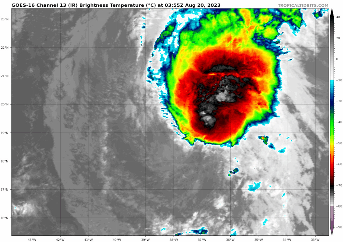
Nice burst of convection tonight. It's dealing with shear but to me it looks like it's enough to be classified as a TC, might need an ASCAT pass to confirm though. Should be short lived, but some models could be showing potential for a comeback further north in the subtropics in few days. Will be interesting to see if something like that happens.
1 likes
B.S Meteorology, University of Oklahoma '25
Please refer to the NHC, NWS, or SPC for official information.
Please refer to the NHC, NWS, or SPC for official information.
Re: ATL: INVEST 98L - Discussion
Looks like a closed LLC to me.
0 likes
TC naming lists: retirements and intensity
Most aggressive Advisory #1's in North Atlantic (cr. kevin for starting the list)
Most aggressive Advisory #1's in North Atlantic (cr. kevin for starting the list)

Re: ATL: INVEST 98L - Discussion
Improved markedly over the last eight hours or so, pretty impressive.
I'm particularly fond of the name Emily (and a recently introduced character of mine) so hopefully this can be a decent ACE producer while remaining over open water if it grabs the name
I'm particularly fond of the name Emily (and a recently introduced character of mine) so hopefully this can be a decent ACE producer while remaining over open water if it grabs the name
0 likes
The above post is not official and should not be used as such. It is the opinion of the poster and may or may not be backed by sound meteorological data. It is not endorsed by any professional institution or storm2k.org. For official information, please refer to the NHC and NWS products.
Re: ATL: INVEST 98L - Discussion
98L is looking in better shape but the shear is still causing it to be stretched out.
Meteosat-10 - https://col.st/mWyu1

Meteosat-10 - https://col.st/mWyu1
0 likes
-
cycloneye
- Admin
- Posts: 149695
- Age: 69
- Joined: Thu Oct 10, 2002 10:54 am
- Location: San Juan, Puerto Rico
Re: ATL: INVEST 98L - Discussion
Central Tropical Atlantic (AL98):
Showers and thunderstorms continue to show signs of organization in
association with an area of low pressure located several hundred
miles west-northwest of the Cabo Verde Islands. Earlier satellite
wind data indicated the system was producing winds up to 40 mph on
its north side. In addition, first light visible satellite suggests
the center may be becoming better defined. If these current trends
continue, a short-lived tropical depression or tropical storm is
likely to form later today or tonight while it moves
west-northwestward at about 10 mph over the central tropical
Atlantic. By Monday, upper-level winds are forecast to strengthen
over the system, and further development is not expected. For
additional information on this system, including gale warnings, see
High Seas Forecasts issued by the National Weather Service.
* Formation chance through 48 hours...high...80 percent.
* Formation chance through 7 days...high...80 percent.
0 likes
Visit the Caribbean-Central America Weather Thread where you can find at first post web cams,radars
and observations from Caribbean basin members Click Here
and observations from Caribbean basin members Click Here
Who is online
Users browsing this forum: Google Adsense [Bot] and 66 guests