ATL: LEE - Models

Moderator: S2k Moderators

Message
Author
Deshaunrob17
Tropical Storm
Tropical Storm
Posts: 207
Joined: Tue Aug 18, 2020 7:49 am

Re: ATL: INVEST 95L - Models

#201 Postby Deshaunrob17 » Mon Sep 04, 2023 1:08 pm

aspen wrote:Today’s 12z HAFS-B run is the strongest model run for 95L so far. It peaks at the very end as a 145 kt/918 mbar Cat 5, thankfully north of the islands.

I was looking at its Stimulated IR4 Brightness and it looks like a West PAC Super Typhoon. Reminds me of Irma too- thankfully the steering pattern not the same
1 likes   

User avatar
kevin
Category 5
Category 5
Posts: 2554
Age: 26
Joined: Wed Aug 28, 2019 4:35 am

Re: ATL: INVEST 95L - Models

#202 Postby kevin » Mon Sep 04, 2023 1:21 pm

12z Euro trending stronger at +96 hrs compared to the last few runs.

Image
1 likes   

User avatar
kevin
Category 5
Category 5
Posts: 2554
Age: 26
Joined: Wed Aug 28, 2019 4:35 am

Re: ATL: INVEST 95L - Models

#203 Postby kevin » Mon Sep 04, 2023 1:24 pm

Deshaunrob17 wrote:
aspen wrote:Today’s 12z HAFS-B run is the strongest model run for 95L so far. It peaks at the very end as a 145 kt/918 mbar Cat 5, thankfully north of the islands.

I was looking at its Stimulated IR4 Brightness and it looks like a West PAC Super Typhoon. Reminds me of Irma too- thankfully the steering pattern not the same


Indeed a very scary-looking storm on HAFS-B. Let's hope it doesn't become a reality or that it becomes a 100% fish if it does.

Image
1 likes   

User avatar
Woofde
Category 1
Category 1
Posts: 475
Joined: Tue Jul 06, 2021 11:33 am

Re: RE: Re: ATL: INVEST 95L - Models

#204 Postby Woofde » Mon Sep 04, 2023 1:25 pm

kevin wrote:
Deshaunrob17 wrote:
aspen wrote:Today’s 12z HAFS-B run is the strongest model run for 95L so far. It peaks at the very end as a 145 kt/918 mbar Cat 5, thankfully north of the islands.

I was looking at its Stimulated IR4 Brightness and it looks like a West PAC Super Typhoon. Reminds me of Irma too- thankfully the steering pattern not the same


Indeed a very scary-looking storm on HAFS-B. Let's hope it doesn't become a reality or that it becomes a 100% fish if it does.

Image
GD, that would be a beautiful storm if it did do that though. The new Hurricane models do have some very pretty outputs.
1 likes   

LarryWx
Category 5
Category 5
Posts: 6246
Joined: Sun Sep 07, 2003 2:04 pm
Location: GA

Re: ATL: INVEST 95L - Models

#205 Postby LarryWx » Mon Sep 04, 2023 1:36 pm

gatorcane wrote:The GFS seems to have a west-bias this year. We saw it for Franklin where it had it hitting Nova Scotia, we saw it with Idalia with it bringing into the FL panhandle, and possibly again with this storm.

The 12Z has shifted east and now is recurving east of the CONUS. While it is too early to say if the CONUS is in the clear, good to see the model shift east like that.

Now Bermuda on the other hand, looks a bit concerning looking at the overall model tracks.

12Z GFS loop from 114 hours:
https://i.postimg.cc/hj08M4D0/gfs-z500a-Norm-atl-fh120-264.gif


The GFS had along with the CMC a strong left bias for Ian last year. The bias for Idalia wasn't as strong, but it was still notably too far left. Thus, if the GFS continues to remain left of most of the others, a possible left bias should probably be kept in mind as a possible influence on its track. OTOH, if the Euro suite were to start going more left/toward the GFS, that would be worrisome.
0 likes   
Personal Forecast Disclaimer:
The posts in this forum are NOT official forecasts and should not be used as such. They are just the opinion of the poster and may or may not be backed by sound meteorological data. They are NOT endorsed by any professional institution or storm2k.org. For official information, please refer to the NHC and NWS products.

Ianswfl
Category 1
Category 1
Posts: 482
Joined: Thu Mar 23, 2023 11:11 pm

Re: ATL: INVEST 95L - Models

#206 Postby Ianswfl » Mon Sep 04, 2023 1:39 pm

Gfs ensembles next fri suggest something weak for west coast of fl from the carribean once again
0 likes   

TimSmith
S2K Supporter
S2K Supporter
Posts: 15
Joined: Tue Aug 25, 2020 10:21 am

Re: ATL: INVEST 95L - Models

#207 Postby TimSmith » Mon Sep 04, 2023 1:46 pm

cheezyWXguy wrote:Anyone writing this off as a fish should take a step back and explore whether they’re really trying to be objective or harping on an emotionally invested outcome.

The thing hasn’t even formed yet, and won’t approach the U.S. east coast for another 8 days. Don’t get too focused on storm tracks for individual deterministic runs. Whether the gfs landfalls it this run, next run, or last run doesn’t really matter at this point. The trends worth watching are at the 500mb level for now, and involve the strength and persistence of the Bermuda high, and the timing and behavior of the east coast trough. The next 5-6 days look pretty locked in, which is most likely good news for the islands. But I’d be paying a bit more attention if I lived on the east coast with all these uncertainties.


Very good point, and also to add to that is the fact that these models generally work as solutions to mathematical differential equations which are very susceptible to small changes in their initial conditions. i.e., a small change to the data fed in regarding the current structure of the storm and/or if it develops a lot more or less as it tracks west over the next few days can have huge impacts on the longer range. Wayyyyy to early to know anything other than anyone than better keep an eye! We should also remind ourselves that even NCH forecast error in the 3-5 day window are significantly high, and individual model error out to the 10 day range are like, well... Anyways, my point is it is way to early to be saying yes it'll do this or it'll do that and all we can really do at current time is look to trends in the shorter run portions of the models forecast and then observe does the storm follow.
1 likes   

User avatar
Landy
Category 1
Category 1
Posts: 338
Joined: Wed Aug 11, 2021 7:43 pm
Location: Port Orange, FL

Re: ATL: INVEST 95L - Models

#208 Postby Landy » Mon Sep 04, 2023 1:47 pm

Um..?! :eek:
Image
2 likes   

User avatar
Blown Away
S2K Supporter
S2K Supporter
Posts: 10140
Joined: Wed May 26, 2004 6:17 am

Re: ATL: INVEST 95L - Models

#209 Postby Blown Away » Mon Sep 04, 2023 1:49 pm

Image

Euro trending back to EC trough.
1 likes   
Hurricane Eye Experience: David 79, Irene 99, Frances 04, Jeanne 04, Wilma 05... EYE COMING MY WAY IN 2024…
Hurricane Brush Experience: Andrew 92, Erin 95, Floyd 99, Matthew 16, Irma 17, Ian 22, Nicole 22…

User avatar
Woofde
Category 1
Category 1
Posts: 475
Joined: Tue Jul 06, 2021 11:33 am

Re: ATL: INVEST 95L - Models

#210 Postby Woofde » Mon Sep 04, 2023 1:50 pm

The Euro usually underdoes intensity too. That's like potentially batting at open Atlantic strength records.
2 likes   

mantis83
Tropical Storm
Tropical Storm
Posts: 198
Joined: Fri Dec 05, 2003 4:47 pm

Re: ATL: INVEST 95L - Models

#211 Postby mantis83 » Mon Sep 04, 2023 1:50 pm

big ole trough on the euro could even push this thing east of bermuda now
2 likes   

User avatar
Blown Away
S2K Supporter
S2K Supporter
Posts: 10140
Joined: Wed May 26, 2004 6:17 am

Re: ATL: INVEST 95L - Models

#212 Postby Blown Away » Mon Sep 04, 2023 1:52 pm

Image
12z Euro… Heading NNE at 216… Looking better by the run for all, except possibly Bermuda…
0 likes   
Hurricane Eye Experience: David 79, Irene 99, Frances 04, Jeanne 04, Wilma 05... EYE COMING MY WAY IN 2024…
Hurricane Brush Experience: Andrew 92, Erin 95, Floyd 99, Matthew 16, Irma 17, Ian 22, Nicole 22…

User avatar
gatorcane
S2K Supporter
S2K Supporter
Posts: 23689
Age: 47
Joined: Sun Mar 13, 2005 3:54 pm
Location: Boca Raton, FL

Re: ATL: INVEST 95L - Models

#213 Postby gatorcane » Mon Sep 04, 2023 1:53 pm

That 917MB deserves a :eek:. Sharp turn NNE with some “weakening” after that

Image
3 likes   

IsabelaWeather
Category 1
Category 1
Posts: 287
Age: 35
Joined: Tue Jul 07, 2020 7:29 am
Location: Isabela, Puerto Rico

Re: ATL: INVEST 95L - Models

#214 Postby IsabelaWeather » Mon Sep 04, 2023 1:55 pm

Spacecoast wrote:06z EPS:
https://i.ibb.co/vCWT0hJ/ef68.jpg


Im catching up on the posts from overnight, but comparing this to the current vis it looks like the center is @~11N and 34.5W moving W at 270*, am I missing something?
1 likes   

User avatar
Blown Away
S2K Supporter
S2K Supporter
Posts: 10140
Joined: Wed May 26, 2004 6:17 am

Re: ATL: INVEST 95L - Models

#215 Postby Blown Away » Mon Sep 04, 2023 1:57 pm

IsabelaWeather wrote:
Spacecoast wrote:06z EPS:
https://i.ibb.co/vCWT0hJ/ef68.jpg


Im catching up on the posts from overnight, but comparing this to the current vis it looks like the center is @~11N and 34.5W moving W at 270*, am I missing something?


Yeah, that’s about right. I think the 2pm was 11.2.
0 likes   
Hurricane Eye Experience: David 79, Irene 99, Frances 04, Jeanne 04, Wilma 05... EYE COMING MY WAY IN 2024…
Hurricane Brush Experience: Andrew 92, Erin 95, Floyd 99, Matthew 16, Irma 17, Ian 22, Nicole 22…

User avatar
Spacecoast
Category 2
Category 2
Posts: 758
Joined: Thu Aug 31, 2017 2:03 pm

Re: ATL: INVEST 95L - Models

#216 Postby Spacecoast » Mon Sep 04, 2023 1:58 pm

TimSmith wrote:Very good point, and also to add to that is the fact that these models generally work as solutions to mathematical differential equations which are very susceptible to small changes in their initial conditions. i.e., a small change to the data fed in regarding the current structure of the storm and/or if it develops a lot more or less as it tracks west over the next few days can have huge impacts on the longer range. ...


Exactly why ensembles were developed...Small changes in the initial conditions (perturbations) are introduced to make up for the fact that the current structure can never be measured exactly. This is due to measurement errors, and equipment tolerances.
1 likes   

User avatar
Blown Away
S2K Supporter
S2K Supporter
Posts: 10140
Joined: Wed May 26, 2004 6:17 am

Re: ATL: INVEST 95L - Models

#217 Postby Blown Away » Mon Sep 04, 2023 2:00 pm

Image

12z Euro… It’s like pinball, nearly all the systems hit the 70W and bing NE and away… :D
0 likes   
Hurricane Eye Experience: David 79, Irene 99, Frances 04, Jeanne 04, Wilma 05... EYE COMING MY WAY IN 2024…
Hurricane Brush Experience: Andrew 92, Erin 95, Floyd 99, Matthew 16, Irma 17, Ian 22, Nicole 22…

User avatar
gatorcane
S2K Supporter
S2K Supporter
Posts: 23689
Age: 47
Joined: Sun Mar 13, 2005 3:54 pm
Location: Boca Raton, FL

Re: ATL: INVEST 95L - Models

#218 Postby gatorcane » Mon Sep 04, 2023 2:00 pm

Euro with the first big cold front of fall into the Eastern CONUS. Those widespread cooler temps caused by the strong front, if it verifies would be enough to turn massive future hurricane “Lee” north well east of the CONUS:

Image
2 likes   

IsabelaWeather
Category 1
Category 1
Posts: 287
Age: 35
Joined: Tue Jul 07, 2020 7:29 am
Location: Isabela, Puerto Rico

Re: ATL: INVEST 95L - Models

#219 Postby IsabelaWeather » Mon Sep 04, 2023 2:02 pm

Blown Away wrote:
IsabelaWeather wrote:
Spacecoast wrote:06z EPS:
https://i.ibb.co/vCWT0hJ/ef68.jpg


Im catching up on the posts from overnight, but comparing this to the current vis it looks like the center is @~11N and 34.5W moving W at 270*, am I missing something?


Yeah, that’s about right. I think the 2pm was 11.2.


That graphic had a continuous WNW track from the inception time. I am watching this closely but so far looks to be south of the tightly clustered tracks and mean.
1 likes   

LarryWx
Category 5
Category 5
Posts: 6246
Joined: Sun Sep 07, 2003 2:04 pm
Location: GA

Re: ATL: INVEST 95L - Models

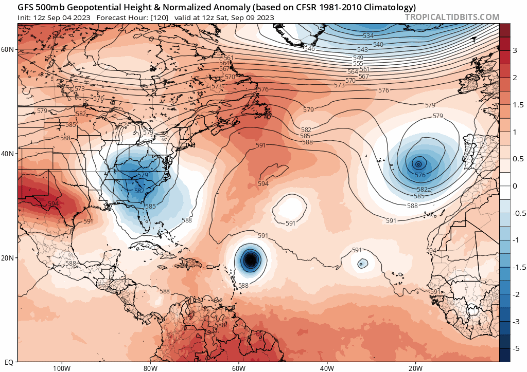
#220 Postby LarryWx » Mon Sep 04, 2023 2:08 pm

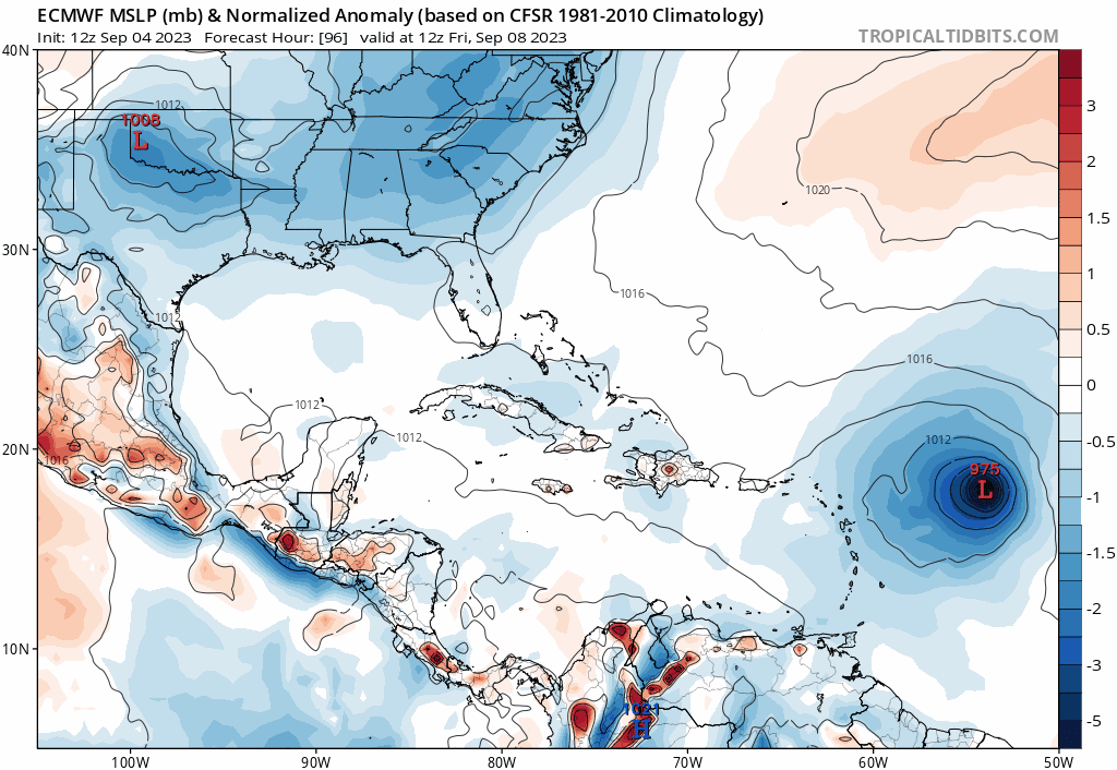
12Z UKMET stronger than 0Z and is a little N of prior run, but it is ~300-350 miles WNW/W of the Euro/CMC/GFS at 168 (end of run) implying not a guarantee it would miss the CONUS, especially NE, had it gone out further:

NEW TROPICAL CYCLONE FORECAST TO DEVELOP AFTER 30 HOURS
FORECAST POSITION AT T+ 30 : 13.2N 39.8W

LEAD CENTRAL MAXIMUM WIND
VERIFYING TIME TIME POSITION PRESSURE (MB) SPEED (KNOTS)
-------------- ---- -------- ------------- -------------
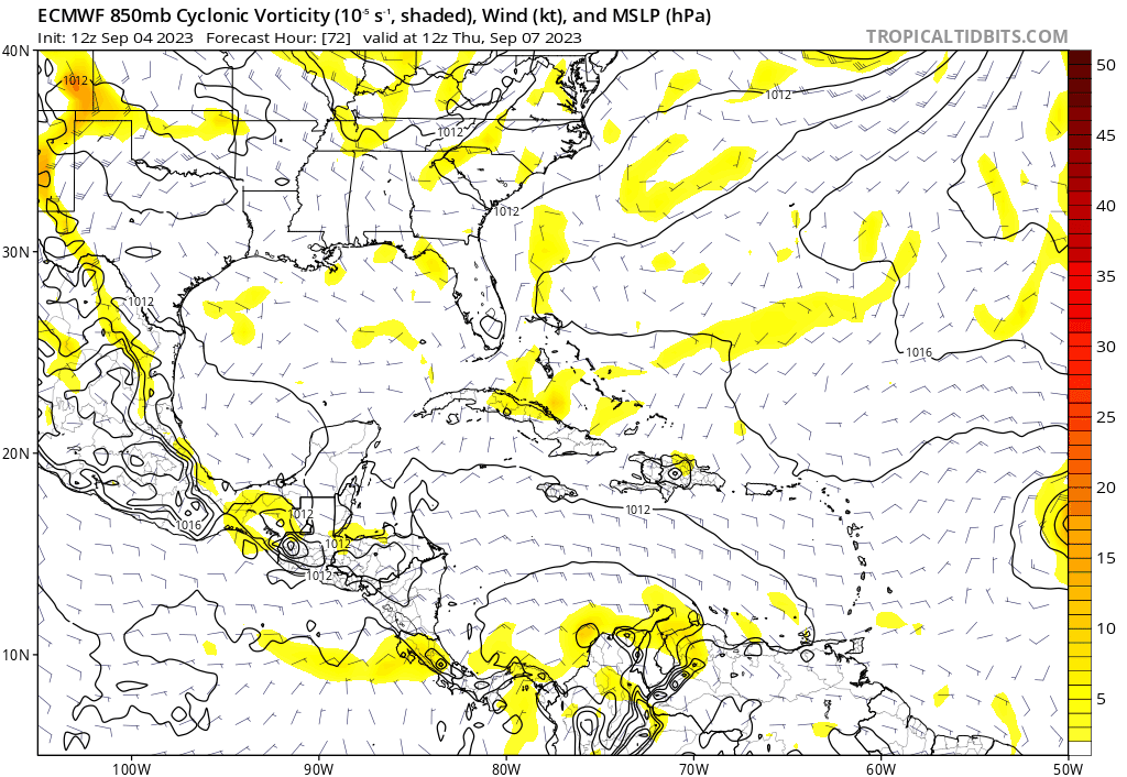
0000UTC 06.09.2023 36 13.8N 41.3W 1010 25
1200UTC 06.09.2023 48 14.4N 44.5W 1007 33
0000UTC 07.09.2023 60 15.7N 46.4W 1007 39
1200UTC 07.09.2023 72 16.9N 49.0W 1005 34
0000UTC 08.09.2023 84 17.8N 51.8W 1005 32
1200UTC 08.09.2023 96 18.9N 55.3W 1005 34
0000UTC 09.09.2023 108 19.9N 58.2W 1005 31
1200UTC 09.09.2023 120 20.2N 60.9W 1004 41
0000UTC 10.09.2023 132 21.1N 63.8W 1000 48
1200UTC 10.09.2023 144 21.7N 65.6W 997 51
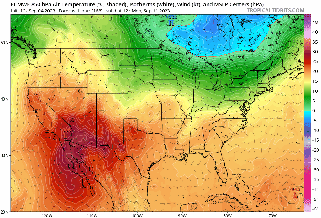
0000UTC 11.09.2023 156 22.8N 67.5W 994 61
1200UTC 11.09.2023 168 23.7N 69.1W 993 57
1 likes   
Personal Forecast Disclaimer:
The posts in this forum are NOT official forecasts and should not be used as such. They are just the opinion of the poster and may or may not be backed by sound meteorological data. They are NOT endorsed by any professional institution or storm2k.org. For official information, please refer to the NHC and NWS products.


Return to “2023”

Who is online

Users browsing this forum: No registered users and 49 guests