ATL: TAMMY - Post-Tropical - Discussion
Moderator: S2k Moderators
-
MarioProtVI
- Category 5

- Posts: 1039
- Age: 24
- Joined: Sun Sep 29, 2019 7:33 pm
- Location: New Jersey
Re: ATL: TAMMY - Hurricane - Discussion
Definitely makes up for Philippe. Though it seems like it just did a Gordon 2018 where it forms a well defined core/eye then some dry air erodes it afterward. It’ll remain 65-70 kt until it gets north of islands IMO
1 likes
-
Sciencerocks
- Category 5
- Posts: 10193
- Age: 40
- Joined: Thu Jul 06, 2017 1:51 am

-
ThunderForce

- Tropical Storm

- Posts: 208
- Age: 26
- Joined: Tue Sep 27, 2022 6:20 pm
- Location: Calhoun County, Florida
Re: ATL: TAMMY - Hurricane - Discussion
Here's the NHC's latest forecast discussion, issued at 5 PM AST:
Hurricane Tammy Discussion Number 10
NWS National Hurricane Center Miami FL AL202023
500 PM AST Fri Oct 20 2023
Moderate shear that is likely undercutting the higher-level outflow
layer has disrupted the inner-core development seen earlier today.
The eye that became apparent in radar imagery from Barbados this
morning has degraded since that time, but there is still a large
curved band that wraps around the eastern and southern portions of
the circulation. The Air Force aircraft that investigated Tammy
through early afternoon measured SFMR winds of around 65 kt during
its final pass through the center, and it reported that the minimum
pressure had fallen to around 991 mb. Although there has been the
recent degradation of the inner core, the initial intensity remains
65 kt, and is based on the earlier aircraft data and more recent
subjective satellite estimates from TAFB and SAB. The next
reconnaissance mission into Tammy is scheduled for this evening.
Very recent radar imagery from Barbados suggest that Tammy may
finally be making its anticipated northwestward turn, however the
long-term motion is still west-northwestward about 6 kt. A more
pronounced northwestward motion should begin very soon as a
trough moving off the east coast of the United States erodes the
western portion of a subtropical ridge over the central Atlantic.
The expected northwestward motion should bring the center of Tammy
near or over portions of the Leeward Islands later tonight and
Saturday. While the numerical model guidance is in relatively good
agreement during the first 48-72 hours of the forecast period, the
spread has greatly increased after that time. The GFS shows a
stronger and more vertically deep cyclone recurving over
west-central Atlantic after day 3, while the latest UKMET and ECMWF
models depict a weaker cyclone that is left behind by an
eastward-moving trough over the western Atlantic. The NHC forecast
continues to predict recurvature, although the latter portion has
been adjusted slower once again.
The environment ahead of Tammy is not predicted to change much
during the next day or so. Warm waters and moderate shear are
expected to allow for some modest strengthening during the next
couple of days, and the NHC intensity forecast during that time is
similar to the previous advisory. After Tammy moves north of the
Leeward Islands, increasing vertical wind shear is likely to
initiate weakening as Tammy moves northward. The NHC intensity
forecast is close to the IVCN intensity aid. Due to the
differences in how fast Tammy recurves, there is more uncertainty
than normal on when Tammy will begin extratropical transition.
The current NHC forecast maintains Tammy as a hurricane through day
5, but if it trends toward the faster side of the guidance it could
be post-tropical by that time.
KEY MESSAGES:
1. Hurricane conditions are expected in portions of the Leeward
Islands by late tonight through Saturday. Tropical storm
conditions are expected to begin in portions of the Lesser Antilles
within the warning area this evening or overnight.
2. Heavy rains from Tammy will begin to affect the Leeward and
northern Windward Islands tonight and Saturday spreading into the
British and U.S. Virgin Islands and Puerto Rico as early as Sunday.
This rainfall may produce isolated flash and urban flooding, along
with isolated mudslides in areas of higher terrain.
3. A storm surge could produce coastal flooding in areas of onshore
winds as the center of Tammy moves near or over the Leeward Islands.
Near the coast, the surge will be accompanied by large and dangerous
waves.
FORECAST POSITIONS AND MAX WINDS
INIT 20/2100Z 14.3N 59.2W 65 KT 75 MPH
12H 21/0600Z 15.3N 60.1W 65 KT 75 MPH
24H 21/1800Z 16.7N 61.2W 70 KT 80 MPH
36H 22/0600Z 18.1N 62.1W 75 KT 85 MPH
48H 22/1800Z 19.5N 63.0W 80 KT 90 MPH
60H 23/0600Z 20.8N 63.4W 80 KT 90 MPH
72H 23/1800Z 22.0N 63.4W 75 KT 85 MPH
96H 24/1800Z 24.5N 61.7W 70 KT 80 MPH
120H 25/1800Z 28.4N 57.7W 65 KT 75 MPH
$$
Forecaster Brown
0 likes
Please refer to the NWS, NHC, SPC or a professional meteorologist for information and decision making during storms.
-
ElectricStorm

- Category 5
- Posts: 5154
- Age: 25
- Joined: Tue Aug 13, 2019 11:23 pm
- Location: Norman, OK
Re: ATL: TAMMY - Hurricane - Discussion
I think this could drop back down to a TS soon while it passes near/through the islands before strengthening into a hurricane again once it gets north. The hurricane models were showing that solution last night, and they did well with this morning's round of intensification.
0 likes
B.S Meteorology, University of Oklahoma '25
Please refer to the NHC, NWS, or SPC for official information.
Please refer to the NHC, NWS, or SPC for official information.


Re: ATL: TAMMY - Hurricane - Discussion
cycloneye wrote:For Msbee and Patti in St Marteen, there is now a Hurricane Warning.Hurricane Tammy Tropical Cyclone Update
NWS National Hurricane Center Miami FL AL202023
215 PM AST Fri Oct 20 2023
The government of St. Maarten has issued a Hurricane Warning for
St. Maarten.
The government of France has issued a Hurricane Warning for St.
Martin and St. Barthelemy.
The government of Antigua has issued a Hurricane Warning for
Anguilla.
$$
Forecaster Brown
Thanks Luis. We are prepared.
3 likes
Too many hurricanes to remember
-
cycloneye

- Admin

- Posts: 149703
- Age: 69
- Joined: Thu Oct 10, 2002 10:54 am
- Location: San Juan, Puerto Rico
Re: ATL: TAMMY - Hurricane - Discussion
msbee wrote:cycloneye wrote:For Msbee and Patti in St Marteen, there is now a Hurricane Warning.Hurricane Tammy Tropical Cyclone Update
NWS National Hurricane Center Miami FL AL202023
215 PM AST Fri Oct 20 2023
The government of St. Maarten has issued a Hurricane Warning for
St. Maarten.
The government of France has issued a Hurricane Warning for St.
Martin and St. Barthelemy.
The government of Antigua has issued a Hurricane Warning for
Anguilla.
$$
Forecaster Brown
Thanks Luis. We are prepared.
Stay safe you and Patti.
2 likes
Visit the Caribbean-Central America Weather Thread where you can find at first post web cams,radars
and observations from Caribbean basin members Click Here
and observations from Caribbean basin members Click Here
-
MarioProtVI
- Category 5
- Posts: 1039
- Age: 24
- Joined: Sun Sep 29, 2019 7:33 pm
- Location: New Jersey
Re: ATL: TAMMY - Hurricane - Discussion
ElectricStorm wrote:I think this could drop back down to a TS soon while it passes near/through the islands before strengthening into a hurricane again once it gets north. The hurricane models were showing that solution last night, and they did well with this morning's round of intensification.
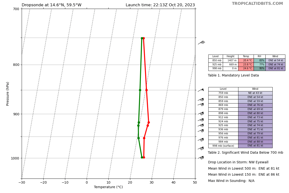
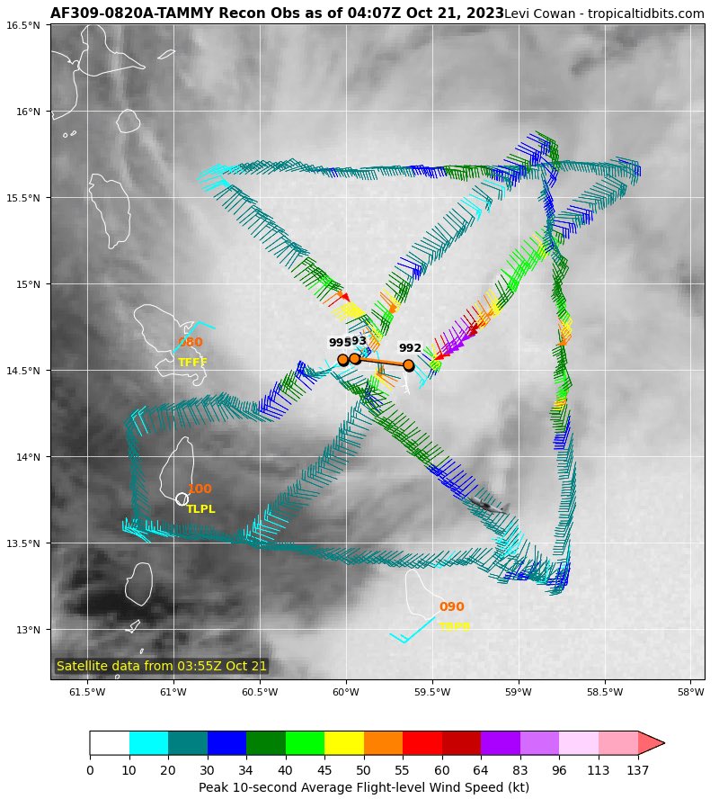
Recon radar and satellite seems to disagree with this considering a big burst just occurred and the eyewall looks stronger again. Also dropsonde supports 989-990 so it hasn’t weakened really.
0 likes
-
Iceresistance

- Category 5
- Posts: 9606
- Age: 22
- Joined: Sat Oct 10, 2020 9:45 am
- Location: Tecumseh, OK/Norman, OK
Re: ATL: TAMMY - Hurricane - Discussion
0 likes
Bill 2015 & Beta 2020
Winter 2020-2021
All observations are in Tecumseh, OK unless otherwise noted.
Winter posts are focused mainly for Oklahoma & Texas.
Take any of my forecasts with a grain of salt, refer to the NWS, SPC, and NHC for official information
Never say Never with weather! Because ANYTHING is possible!
Winter 2020-2021
All observations are in Tecumseh, OK unless otherwise noted.
Winter posts are focused mainly for Oklahoma & Texas.
Take any of my forecasts with a grain of salt, refer to the NWS, SPC, and NHC for official information
Never say Never with weather! Because ANYTHING is possible!
-
Hurrilurker

- Category 2

- Posts: 738
- Joined: Mon Jun 09, 2003 3:32 pm
- Location: San Francisco, CA
Re: ATL: TAMMY - Hurricane - Discussion
Maybe not a major, but some of those islands will get raked pretty good, and many people might be more unprepared/reckless than usual because there hasn't been weeks of hype leading up to the monster storm of the century landfall. I feel bad for Anguilla, we went there a few years ago and they still hadn't recovered from Irma.
1 likes
-
Sciencerocks
- Category 5
- Posts: 10193
- Age: 40
- Joined: Thu Jul 06, 2017 1:51 am

Re: ATL: TAMMY - Hurricane - Discussion
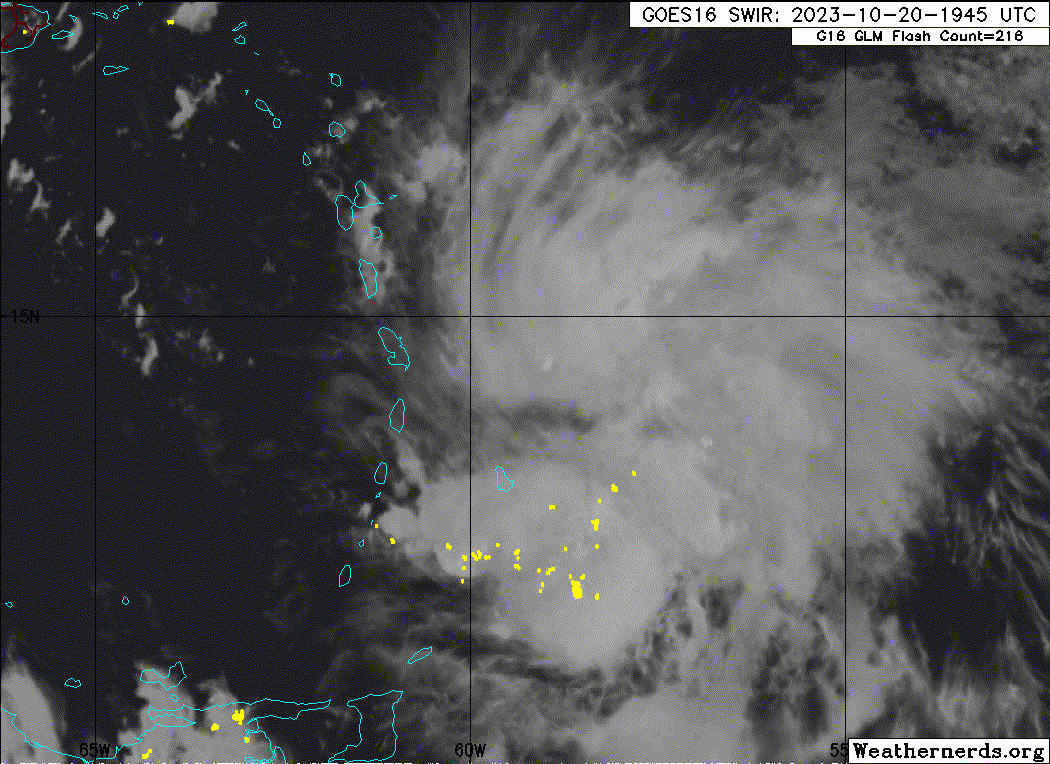
Haven't seen a dramatic turn to the north yet. Movement still looks primarily westward. Looks more likely that a landfall occurs somewhere, but always the chance it corrects northward.
Latest view from Guadeloupe's radar:

Latest view from Guadeloupe's radar:
2 likes
-
Sciencerocks
- Category 5
- Posts: 10193
- Age: 40
- Joined: Thu Jul 06, 2017 1:51 am

-
floridasun
- Tropical Storm
- Posts: 245
- Joined: Tue Sep 14, 2021 3:59 pm
Re: ATL: TAMMY - Hurricane - Discussion
Still moving wnw now nhc have doubt that will move nw anytime soon so Islands will get more impact from hurricane that now winds of 80s
2 likes
-
emeraldislenc
- Category 2
- Posts: 601
- Joined: Fri Aug 24, 2012 4:49 pm
- Location: Emerald Isle NC
Re: ATL: TAMMY - Hurricane - Discussion
Any chance it could miss the front and continue more west?
0 likes
-
floridasun
- Tropical Storm
- Posts: 245
- Joined: Tue Sep 14, 2021 3:59 pm
Re: ATL: TAMMY - Hurricane - Discussion
emeraldislenc wrote:Any chance it could miss the front and continue more west?
Dend on front speed now hurricane moving slow so we need see what it do morning
0 likes
-
Hurricane Mike
- Category 2
- Posts: 675
- Joined: Tue Apr 10, 2018 7:44 am
Re: ATL: TAMMY - Hurricane - Discussion
Eye getting pretty darn close to Martinique. Looks like it'll be a close call for Dominica as well.
Video Update on Hurricane Tammy
https://www.youtube.com/watch?v=LgSxzDkQ72A
Video Update on Hurricane Tammy
https://www.youtube.com/watch?v=LgSxzDkQ72A
1 likes
-
AubreyStorm

- Category 1

- Posts: 337
- Age: 45
- Joined: Fri Jun 16, 2017 6:21 pm
- Location: Texas, USA
Re: ATL: TAMMY - Hurricane - Discussion
I think NHC will change next advisory?
Due west!
Due west!
0 likes
The posts are NOT an official forecast. Please REFER to the NHC and NWS for official forecasts and products.

Re: ATL: TAMMY - Hurricane - Discussion
AubreyStorm wrote:I think NHC will change next advisory?
Due west!
https://pbs.twimg.com/media/F87-7w2WkAAHp8K.jpg
Why do FL winds seem so weak?
0 likes
TC naming lists: retirements and intensity
Most aggressive Advisory #1's in North Atlantic (cr. kevin for starting the list)
Most aggressive Advisory #1's in North Atlantic (cr. kevin for starting the list)
-
Sciencerocks
- Category 5
- Posts: 10193
- Age: 40
- Joined: Thu Jul 06, 2017 1:51 am


Re: ATL: TAMMY - Hurricane - Discussion
Strongest flight level winds are east of the center except when there has been a perceptible eyewall.
Looks like it is tracking more NW now but eastern side of Guadalupe may get some heavy gusts in squalls.
If there is an upsurge in squall activity as it passes over any particular Leeward island there is risk of tornado activity and down bursts along with severe flooding. Preparation for all that is not unlike hurricane prep so you have to exercise the the plan anyway.
0 likes
Who is online
Users browsing this forum: No registered users and 72 guests