ATL: LEE - Models
Moderator: S2k Moderators
-
ElectricStorm

- Category 5

- Posts: 5128
- Age: 25
- Joined: Tue Aug 13, 2019 11:23 pm
- Location: Norman, OK
Re: ATL: LEE - Models
Nuclear HAFS-B run, so close to sub-900. Peaks at 160kts/901mb
3 likes
B.S Meteorology, University of Oklahoma '25
Please refer to the NHC, NWS, or SPC for official information.
Please refer to the NHC, NWS, or SPC for official information.
Re: ATL: LEE - Models
Meteorcane wrote:mantis83 wrote:a safe recurve is looking more and more likely as we get closer in time.....
Still too much uncertainty in the long term to feel too safe about Bermuda, Atlantic Canada, and the NE US. I still wouldn't necessarily say there is no threat for the Turks and Caicos and eastern Bahamas either... only takes a somewhat stronger ridge.
If anything, the risk to Bermuda is increasing. But the risk to the NE US, after a bit of a concern largely based on the far left UKMET, has dropped somewhat from how it looked earlier. Hopefully future UKMETs will not go back as far left as they were. However, I'm still maintaining a small risk of landfall to the NE US because we're still 9 or so days out...too long to give an all clear.
0 likes
Personal Forecast Disclaimer:
The posts in this forum are NOT official forecasts and should not be used as such. They are just the opinion of the poster and may or may not be backed by sound meteorological data. They are NOT endorsed by any professional institution or storm2k.org. For official information, please refer to the NHC and NWS products.
The posts in this forum are NOT official forecasts and should not be used as such. They are just the opinion of the poster and may or may not be backed by sound meteorological data. They are NOT endorsed by any professional institution or storm2k.org. For official information, please refer to the NHC and NWS products.


Re: ATL: LEE - Models
Why does the Euro have to ruin it for everyone  , recurve is not yet guaranteed at all. Probably a New Jersey or New York hit beyond 240 hrs.
3 likes
-
weeniepatrol

- Category 5
- Posts: 1339
- Joined: Sat Aug 22, 2020 5:30 pm
- Location: WA State
Re: ATL: LEE - Models
kevin wrote:Why does the Euro have to ruin it for everyone
https://imgur.com/IduiJRJ
And another tropical cyclone developing in the MDR lol
4 likes
-
Blown Away

- S2K Supporter

- Posts: 10253
- Joined: Wed May 26, 2004 6:17 am
Re: ATL: LEE - Models
weeniepatrol wrote:kevin wrote:Why does the Euro have to ruin it for everyone
https://imgur.com/IduiJRJ
And another tropical cyclone developing in the MDR lol
00z Euro Trend…
0 likes
Hurricane Eye Experience: David 79, Irene 99, Frances 04, Jeanne 04, Wilma 05… Hurricane Brush Experience: Andrew 92, Erin 95, Floyd 99, Matthew 16, Irma 17, Ian 22, Nicole 22…
-
SFLcane

- S2K Supporter
- Posts: 10281
- Age: 48
- Joined: Sat Jun 05, 2010 1:44 pm
- Location: Lake Worth Florida
Re: ATL: LEE - Models
.
Last edited by SFLcane on Wed Sep 06, 2023 7:41 am, edited 1 time in total.
2 likes
Re: ATL: LEE - Models
6z gfs has another major hurricane in the long range that takes the same path we've seen all season.....
1 likes
Re: ATL: LEE - Models
Last 5 EPS runs (0Z and 12Z only): # of members with CONUS H landfall
0Z 9/6: 5 (10%)
12Z 9/5: 2 (4%)
0Z 9/5: 4 (8%)
12Z 9/4: 1 (2%)
0Z 9/4: 2 (4%)
So, although still a small %, the latest run has the highest yet.
0Z 9/6: 5 (10%)
12Z 9/5: 2 (4%)
0Z 9/5: 4 (8%)
12Z 9/4: 1 (2%)
0Z 9/4: 2 (4%)
So, although still a small %, the latest run has the highest yet.
1 likes
Personal Forecast Disclaimer:
The posts in this forum are NOT official forecasts and should not be used as such. They are just the opinion of the poster and may or may not be backed by sound meteorological data. They are NOT endorsed by any professional institution or storm2k.org. For official information, please refer to the NHC and NWS products.
The posts in this forum are NOT official forecasts and should not be used as such. They are just the opinion of the poster and may or may not be backed by sound meteorological data. They are NOT endorsed by any professional institution or storm2k.org. For official information, please refer to the NHC and NWS products.
-
cycloneye

- Admin

- Posts: 149222
- Age: 69
- Joined: Thu Oct 10, 2002 10:54 am
- Location: San Juan, Puerto Rico
Re: ATL: LEE - Models
1 likes
Visit the Caribbean-Central America Weather Thread where you can find at first post web cams,radars
and observations from Caribbean basin members Click Here
and observations from Caribbean basin members Click Here


Re: ATL: LEE - Models
Last run was even stronger at 160 kt/901 mbar, an even stronger version of Dorian or Irma. It shows RI starting Thursday evening into Friday morning.
1 likes
Irene '11 Sandy '12 Hermine '16 5/15/2018 Derecho Fay '20 Isaias '20 Elsa '21 Henri '21 Ida '21
I am only a meteorology enthusiast who knows a decent amount about tropical cyclones. Look to the professional mets, the NHC, or your local weather office for the best information.
I am only a meteorology enthusiast who knows a decent amount about tropical cyclones. Look to the professional mets, the NHC, or your local weather office for the best information.
-
cheezyWXguy

- Category 5
- Posts: 6280
- Joined: Mon Feb 13, 2006 12:29 am
- Location: Dallas, TX
Re: ATL: LEE - Models
mantis83 wrote:6z gfs has another major hurricane in the long range that takes the same path we've seen all season.....
What path is that?
0 likes
Re: ATL: LEE - Models
The 6Z Euro hour 72 is slightly E of 0Z 78 and similar to yesterday's 12Z at 90.
0 likes
Personal Forecast Disclaimer:
The posts in this forum are NOT official forecasts and should not be used as such. They are just the opinion of the poster and may or may not be backed by sound meteorological data. They are NOT endorsed by any professional institution or storm2k.org. For official information, please refer to the NHC and NWS products.
The posts in this forum are NOT official forecasts and should not be used as such. They are just the opinion of the poster and may or may not be backed by sound meteorological data. They are NOT endorsed by any professional institution or storm2k.org. For official information, please refer to the NHC and NWS products.
-
AutoPenalti
- Category 5
- Posts: 4091
- Age: 29
- Joined: Mon Aug 17, 2015 4:16 pm
- Location: Ft. Lauderdale, Florida
Re: ATL: LEE - Models
cheezyWXguy wrote:mantis83 wrote:6z gfs has another major hurricane in the long range that takes the same path we've seen all season.....
What path is that?
his favorite word. "OTS"
9 likes
The posts in this forum are NOT official forecasts and should not be used as such. They are just the opinion of the poster and may or may not be backed by sound meteorological data. They are NOT endorsed by any professional institution or STORM2K. For official information, please refer to products from the NHC and NWS.
Model Runs Cheat Sheet:
GFS (5:30 AM/PM, 11:30 AM/PM)
HWRF, GFDL, UKMET, NAVGEM (6:30-8:00 AM/PM, 12:30-2:00 AM/PM)
ECMWF (1:45 AM/PM)
TCVN is a weighted averaged
-
Stormcenter
- S2K Supporter
- Posts: 6689
- Joined: Wed Sep 03, 2003 11:27 am
- Location: Houston, TX
-
cheezyWXguy
- Category 5
- Posts: 6280
- Joined: Mon Feb 13, 2006 12:29 am
- Location: Dallas, TX
Re: ATL: LEE - Models
AutoPenalti wrote:cheezyWXguy wrote:mantis83 wrote:6z gfs has another major hurricane in the long range that takes the same path we've seen all season.....
What path is that?
his favorite word. "OTS"
Ha it’s my favorite path too, but it’s not ots unless we’ve collectively decided that Maine and Atlantic Canada don’t exist anymore
3 likes
Re: ATL: LEE - Models
Stormcenter wrote:Can you say fish storm?
Nope Bermuda and Atlantic Canada exist. But I think OBX and especially north of there and Bermuda are possible. Bermuda/Canada probably the highest probability right now on a rather sketchy and subject to change scale.
0 likes
-
Hybridstorm_November2001

- S2K Supporter
- Posts: 2817
- Joined: Sat Aug 21, 2004 2:50 pm
- Location: SW New Brunswick, Canada
- Contact:
Re: ATL: LEE - Models
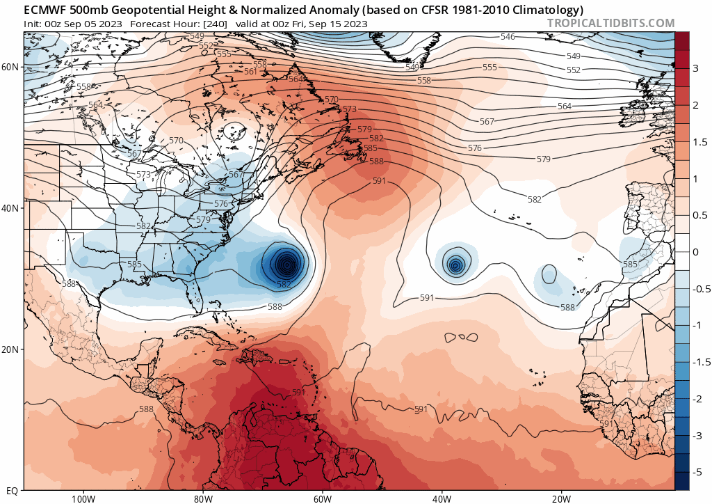
I watched a pair of retired pro mets from the NE last night (NYC and Northern New Jersey) they examined several model runs of the GFS, Euro, and Gem explaining why the long-range solution is all over the place. The key factors are the evolution of two troughs the first of which comes down this weekend and the second of which comes down mid-late next week. The models have been handling these features differently from run to run something that hasn't changed this morning I see. Interesting times ahead.
1 likes

Re: ATL: LEE - Models
Blown Away wrote:weeniepatrol wrote:kevin wrote:Why does the Euro have to ruin it for everyone
https://imgur.com/IduiJRJ
And another tropical cyclone developing in the MDR lol
[url]https://i.postimg.cc/tgkDH4qM/ec-fast-z500a-Norm-atl-fh216-trend.gif [/url]
00z Euro Trend…
That's quite a south and west jump... lets see if it trends.
1 likes
Who is online
Users browsing this forum: No registered users and 14 guests