
ATL: TAMMY - Models
Moderator: S2k Moderators
-
tolakram
- Admin

- Posts: 20186
- Age: 62
- Joined: Sun Aug 27, 2006 8:23 pm
- Location: Florence, KY (name is Mark)
Re: ATL: INVEST 94L - Models
Looking at the Euro shear anomalies, you can see why this develops (at least in the last few runs). This starts at 120 hours.
1 likes
M a r k
- - - - -
Join us in chat: Storm2K Chatroom Invite. Android and IOS apps also available.
The posts in this forum are NOT official forecasts and should not be used as such. Posts are NOT endorsed by any professional institution or STORM2K.org. For official information and forecasts, please refer to NHC and NWS products.
-
cycloneye

- Admin
- Posts: 149730
- Age: 69
- Joined: Thu Oct 10, 2002 10:54 am
- Location: San Juan, Puerto Rico
Re: ATL: INVEST 94L - Models
tolakram wrote:Looking at the Euro shear anomalies, you can see why this develops (at least in the last few runs). This starts at 120 hours.
https://i.imgur.com/DZPW4d4.gif
There is a blue pocket near and over the leewards. Dont like.
0 likes
Visit the Caribbean-Central America Weather Thread where you can find at first post web cams,radars
and observations from Caribbean basin members Click Here
and observations from Caribbean basin members Click Here
-
cycloneye
- Admin
- Posts: 149730
- Age: 69
- Joined: Thu Oct 10, 2002 10:54 am
- Location: San Juan, Puerto Rico
Re: ATL: INVEST 94L - Models
Comparison between GFS, CMC, ICON and European. The first three are from 12z and Euro is the 00z one.

6 likes
Visit the Caribbean-Central America Weather Thread where you can find at first post web cams,radars
and observations from Caribbean basin members Click Here
and observations from Caribbean basin members Click Here
-
wxman57

- Moderator-Pro Met

- Posts: 23175
- Age: 68
- Joined: Sat Jun 21, 2003 8:06 pm
- Location: Houston, TX (southwest)
Re: ATL: INVEST 94L - Models
18Z Consensus (TVCN) turns it NW a little farther east. 12Z EC turns it north before reaching the islands. It has a very small TS. Canadian has a hurricane passing right over the NE Caribbean islands next Friday. Canadian is generally a poor model to use for TCs, though.
Numbers are date/CDT time:
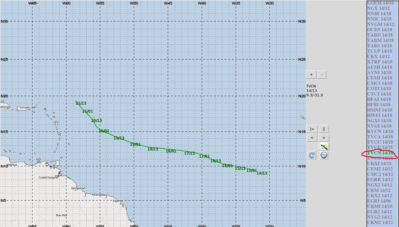
Numbers are date/CDT time:
1 likes
-
MarioProtVI
- Category 5

- Posts: 1039
- Age: 24
- Joined: Sun Sep 29, 2019 7:33 pm
- Location: New Jersey
ATL: INVEST 94L - Discussion
Why have the models done so badly this year? Ever since Lee models have been trash at predicting things and/or things underperformed, including:
- Not expecting SW shear that truncated Lee’s C5 peak to 12 hours instead and weakened it rather then the forecasted 3/4 days
- Struggling with Nigel and making it a major (instead only a large C2)
- The failure with Philippe and Rina (much weaker then expected, especially the latter).
- Expecting Sean to be a hurricane (never got beyond sheared 45 mph mess)
And now this. I’d rather just take this not developing at all or a weak TD so we don’t make our NS:H ratio worse (it is 19:6 rn which is basically 2019/21 levels).
9 likes
Re: ATL: INVEST 94L - Discussion
MarioProtVI wrote:Why have the models done so badly this year? Ever since Lee models have been trash at predicting things and/or things underperformed, including:
- Not expecting SW shear that truncated Lee’s C5 peak to 12 hours instead and weakened it rather then the forecasted 3/4 days
- Struggling with Nigel and making it a major (instead only a large C2)
- The failure with Philippe and Rina (much weaker then expected, especially the latter).
- Expecting Sean to be a hurricane (never got beyond sheared 45 mph mess)
And now this. I’d rather just take this not developing at all or a weak TD so we don’t make our NS:H ratio worse (it is 19:6 rn which is basically 2019/21 levels).
You've done your homework, good post...
0 likes
-
WalterWhite

- Category 1

- Posts: 342
- Joined: Fri Mar 17, 2023 5:53 pm
-
cycloneye
- Admin
- Posts: 149730
- Age: 69
- Joined: Thu Oct 10, 2002 10:54 am
- Location: San Juan, Puerto Rico
Re: ATL: INVEST 94L - Discussion
MarioProtVI wrote:Why have the models done so badly this year? Ever since Lee models have been trash at predicting things and/or things underperformed, including:
- Not expecting SW shear that truncated Lee’s C5 peak to 12 hours instead and weakened it rather then the forecasted 3/4 days
- Struggling with Nigel and making it a major (instead only a large C2)
- The failure with Philippe and Rina (much weaker then expected, especially the latter).
- Expecting Sean to be a hurricane (never got beyond sheared 45 mph mess)
And now this. I’d rather just take this not developing at all or a weak TD so we don’t make our NS:H ratio worse (it is 19:6 rn which is basically 2019/21 levels).
This is one of the best posts of 2023.
6 likes
Visit the Caribbean-Central America Weather Thread where you can find at first post web cams,radars
and observations from Caribbean basin members Click Here
and observations from Caribbean basin members Click Here
-
cycloneye
- Admin
- Posts: 149730
- Age: 69
- Joined: Thu Oct 10, 2002 10:54 am
- Location: San Juan, Puerto Rico
Re: ATL: INVEST 94L - Models
Well, GFS is back with development.

1 likes
Visit the Caribbean-Central America Weather Thread where you can find at first post web cams,radars
and observations from Caribbean basin members Click Here
and observations from Caribbean basin members Click Here
-
MarioProtVI
- Category 5
- Posts: 1039
- Age: 24
- Joined: Sun Sep 29, 2019 7:33 pm
- Location: New Jersey
Re: ATL: INVEST 94L - Models
That’s moreso a product of the 18z shenanigans the GFS does at this time. Don’t think it’s representing what will actually happen. Most likely will be broad slop again at 00z run.
1 likes
-
tolakram
- Admin
- Posts: 20186
- Age: 62
- Joined: Sun Aug 27, 2006 8:23 pm
- Location: Florence, KY (name is Mark)
Re: ATL: INVEST 94L - Models
I think the explanation is pretty simple. There IS an el nino background state AND some very favorable conditions in the Atlantic. If a storm can thread the needle it will take off, but as soon as I see models flipping back and forth it means to me that the odds of all the events lining up are getting worse. Add to that the fact models always seem to have issues with pattern changes and ... good luck. There's still a chance 94L takes off, but I think the models might be the last to know. 
4 likes
M a r k
- - - - -
Join us in chat: Storm2K Chatroom Invite. Android and IOS apps also available.
The posts in this forum are NOT official forecasts and should not be used as such. Posts are NOT endorsed by any professional institution or STORM2K.org. For official information and forecasts, please refer to NHC and NWS products.
- - - - -
Join us in chat: Storm2K Chatroom Invite. Android and IOS apps also available.
The posts in this forum are NOT official forecasts and should not be used as such. Posts are NOT endorsed by any professional institution or STORM2K.org. For official information and forecasts, please refer to NHC and NWS products.
-
dexterlabio
- Category 5
- Posts: 3518
- Joined: Sat Oct 24, 2009 11:50 pm
Re: ATL: INVEST 94L - Models
Well it appears that the models have been the last to know lately, starting with Philippe.
2 likes
Personal Forecast Disclaimer:
The posts in this forum are NOT official forecast and should not be used as such. They are just the opinion of the poster and may or may not be backed by sound meteorological data. They are NOT endorsed by any professional institution or storm2k.org. For official information, please refer to the NHC and NWS products.
The posts in this forum are NOT official forecast and should not be used as such. They are just the opinion of the poster and may or may not be backed by sound meteorological data. They are NOT endorsed by any professional institution or storm2k.org. For official information, please refer to the NHC and NWS products.
-
cycloneye
- Admin
- Posts: 149730
- Age: 69
- Joined: Thu Oct 10, 2002 10:54 am
- Location: San Juan, Puerto Rico
Re: ATL: INVEST 94L - Models
I am also skeptical about a fast developmemt.
https://twitter.com/AndyHazelton/status/1713947535914475804
https://twitter.com/AndyHazelton/status/1713947535914475804
1 likes
Visit the Caribbean-Central America Weather Thread where you can find at first post web cams,radars
and observations from Caribbean basin members Click Here
and observations from Caribbean basin members Click Here
-
cycloneye
- Admin
- Posts: 149730
- Age: 69
- Joined: Thu Oct 10, 2002 10:54 am
- Location: San Juan, Puerto Rico
Re: ATL: INVEST 94L - Models
0 likes
Visit the Caribbean-Central America Weather Thread where you can find at first post web cams,radars
and observations from Caribbean basin members Click Here
and observations from Caribbean basin members Click Here
-
tolakram
- Admin
- Posts: 20186
- Age: 62
- Joined: Sun Aug 27, 2006 8:23 pm
- Location: Florence, KY (name is Mark)
Re: ATL: INVEST 94L - Models
cycloneye wrote:[Xpost]https://twitter.com/AndyHazelton/status/1713947535914475804 [/Xpost]
Your link is to twitter.com, so still use tweet
2 likes
M a r k
- - - - -
Join us in chat: Storm2K Chatroom Invite. Android and IOS apps also available.
The posts in this forum are NOT official forecasts and should not be used as such. Posts are NOT endorsed by any professional institution or STORM2K.org. For official information and forecasts, please refer to NHC and NWS products.
- - - - -
Join us in chat: Storm2K Chatroom Invite. Android and IOS apps also available.
The posts in this forum are NOT official forecasts and should not be used as such. Posts are NOT endorsed by any professional institution or STORM2K.org. For official information and forecasts, please refer to NHC and NWS products.
Re: ATL: INVEST 94L - Models
The 12Z UKMET has no TC from this.
0 likes
Personal Forecast Disclaimer:
The posts in this forum are NOT official forecasts and should not be used as such. They are just the opinion of the poster and may or may not be backed by sound meteorological data. They are NOT endorsed by any professional institution or storm2k.org. For official information, please refer to the NHC and NWS products.
The posts in this forum are NOT official forecasts and should not be used as such. They are just the opinion of the poster and may or may not be backed by sound meteorological data. They are NOT endorsed by any professional institution or storm2k.org. For official information, please refer to the NHC and NWS products.
Re: ATL: INVEST 94L - Models
Euro ensembles mega shift west. Couple models look interesting for us in Florida
0 likes
-
Blown Away

- S2K Supporter

- Posts: 10253
- Joined: Wed May 26, 2004 6:17 am
Re: ATL: INVEST 94L - Models
Ianswfl wrote:Euro ensembles mega shift west. Couple models look interesting for us in Florida
0 likes
Hurricane Eye Experience: David 79, Irene 99, Frances 04, Jeanne 04, Wilma 05… Hurricane Brush Experience: Andrew 92, Erin 95, Floyd 99, Matthew 16, Irma 17, Ian 22, Nicole 22…
Re: ATL: INVEST 94L - Models
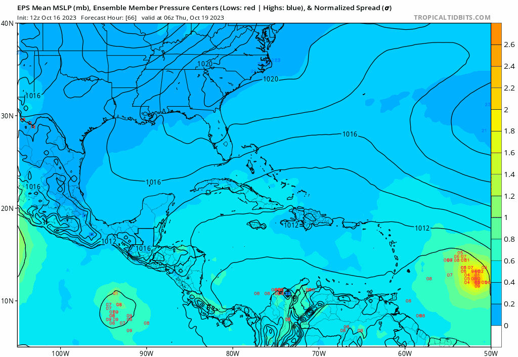
Blown Away wrote:Ianswfl wrote:Euro ensembles mega shift west. Couple models look interesting for us in Florida
[url]https://i.postimg.cc/pr220f9J/eps-lowlocs-watl-fh66-312.gif [/url]
Do you think this is really possible? Euro is the most accurate model. Late oct and a strong mdr storm moving westward. If that stays north of haiti and move west waters are still warm. Another kate path?
0 likes
-
Blown Away
- S2K Supporter
- Posts: 10253
- Joined: Wed May 26, 2004 6:17 am
Re: ATL: INVEST 94L - Models
Blown Away wrote:Ianswfl wrote:Euro ensembles mega shift west. Couple models look interesting for us in Florida
[url]https://i.postimg.cc/pr220f9J/eps-lowlocs-watl-fh66-312.gif [/url]
I’d say pretty low confidence, Nicole was extremely rare Nov track and to have it 2 years in a row seems very unlikely.
1 likes
Hurricane Eye Experience: David 79, Irene 99, Frances 04, Jeanne 04, Wilma 05… Hurricane Brush Experience: Andrew 92, Erin 95, Floyd 99, Matthew 16, Irma 17, Ian 22, Nicole 22…
Who is online
Users browsing this forum: No registered users and 37 guests