
So, next Friday, a surface low is expected to form along the front in New England.
May give Lee a tug to turn NW
https://www.wpc.ncep.noaa.gov/#
ATL: LEE - Models
Moderator: S2k Moderators
-
PavelGaborik10
- Category 1

- Posts: 472
- Joined: Tue Sep 04, 2018 3:23 pm
-
hohnywx
- Category 2

- Posts: 511
- Age: 34
- Joined: Sun Jul 19, 2009 8:34 pm
- Location: Hastings-on-Hudson, NY
Re: ATL: LEE - Models
0 likes
Re: ATL: LEE - Models
GFS Trend (it almost looks like just an animated run just from the repositioning/speed). The swings with Margot tell me this is stupidly low confidence in general for Lee.

Last edited by BobHarlem on Fri Sep 08, 2023 11:32 am, edited 3 times in total.
1 likes
-
PavelGaborik10
- Category 1
- Posts: 472
- Joined: Tue Sep 04, 2018 3:23 pm
Re: ATL: LEE - Models
hohnywx wrote:PavelGaborik10 wrote:GFS a hair west, possibly into Maine.
Direct hit on Nova Scotia
https://imgur.com/B7YQJtn
That would put Halifax directly in the strongest winds, last second hook E makes the world of difference.
It's going to be another several days at least of Doomsday runs until we finally get a general area locked down it seems.
What a rough forecast
2 likes
Re: ATL: LEE - Models
CMC and GFS run to run are completely all over the place with Margot, which makes me doubt them on Lee all that much more. Icon's generally not that great but it has at least been consistent with both Lee and Margot.
12z Canadian:
New on that is the system approaching and scraping the islands, Margot shifted way north from 0z, and Lee shifted slightly east. Prepare for the models to be garbage until much closer.

12z Canadian:
New on that is the system approaching and scraping the islands, Margot shifted way north from 0z, and Lee shifted slightly east. Prepare for the models to be garbage until much closer.
1 likes
-
SootyTern
- S2K Supporter

- Posts: 316
- Age: 57
- Joined: Sun Sep 05, 2004 5:09 pm
- Location: NYC (formerly Homestead, FL)
Re: ATL: LEE - Models
Is there anything special about Margot that is giving the models so much trouble? Is it just because she is in an area of fewer weather observations?
1 likes
Disclaimer:
The posts in this forum are NOT official forecasts and should not be used as such. For official information, please refer to the NHC and NWS products.
Gulf Coast: Opal '95 Georges '98 / So Fla: Katrina '05 Wilma '05 Irma '17
The posts in this forum are NOT official forecasts and should not be used as such. For official information, please refer to the NHC and NWS products.
Gulf Coast: Opal '95 Georges '98 / So Fla: Katrina '05 Wilma '05 Irma '17
Re: ATL: LEE - Models
LarryWx wrote:0Z EPS through 240: not as many hits on US as 12Z run but there still were 7: 6 on ME and 1 on NY. There may not be any more US hits after 240. Nova Scotia gets clobbered even more than on the 12Z. Newfoundland also gets some direct hits in addition to leftovers from some of the Nova Scotia hits.
I saw no more direct US hits on the 0Z EPS after hour 240. So, the hit % for the US went down from 24% to 14%. ME remains at the highest risk of any US state per the EPS:
Summary of recent EPS runs' US landfalls:
9/8 0Z: 7 (14%) 9/15-17 (6 ME, 1 NY)
9/7 12Z: 12 (24%) 9/15-19 (7 ME, 3 MA, 1 NY, 1 NJ)
9/7 0Z: 10 (20%) 9/15-18 (5 ME, 5 MA)
9/6 12Z: 3 (6%) 9/15-18 (2 ME, 1 MA)
9/6 0Z: 5 (10%)
9/5 12Z: 2 (4%)
9/5 0Z: 4 (8%)
9/4 12Z: 1 (2%)
9/4 0Z: 2 (4%)
Last edited by LarryWx on Fri Sep 08, 2023 1:04 pm, edited 1 time in total.
3 likes
Personal Forecast Disclaimer:
The posts in this forum are NOT official forecasts and should not be used as such. They are just the opinion of the poster and may or may not be backed by sound meteorological data. They are NOT endorsed by any professional institution or storm2k.org. For official information, please refer to the NHC and NWS products.
The posts in this forum are NOT official forecasts and should not be used as such. They are just the opinion of the poster and may or may not be backed by sound meteorological data. They are NOT endorsed by any professional institution or storm2k.org. For official information, please refer to the NHC and NWS products.
-
gatorcane

- S2K Supporter
- Posts: 23708
- Age: 48
- Joined: Sun Mar 13, 2005 3:54 pm
- Location: Boca Raton, FL
Re: ATL: LEE - Models
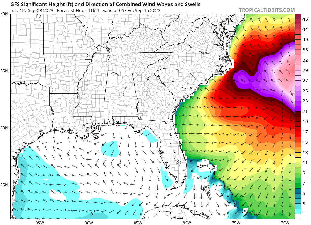
If the GFS is correct, looks like some significant waves caused by Lee from the east coast of Central Florida up the entire eastern seaboard with 25ft waves just offshore the outer banks of NC.
2 likes

-
Iceresistance

- Category 5

- Posts: 9575
- Age: 22
- Joined: Sat Oct 10, 2020 9:45 am
- Location: Tecumseh, OK/Norman, OK
Re: ATL: LEE - Models
chris_fit wrote:EURO coming in decently S at 86 hrs
Yeah, I don't like that southern dip, allows Lee to become more stronger with the higher OHCs (unless the wind shear increases)
1 likes
Bill 2015 & Beta 2020
Winter 2020-2021
All observations are in Tecumseh, OK unless otherwise noted.
Winter posts are focused mainly for Oklahoma & Texas.
Take any of my forecasts with a grain of salt, refer to the NWS, SPC, and NHC for official information
Never say Never with weather! Because ANYTHING is possible!
Winter 2020-2021
All observations are in Tecumseh, OK unless otherwise noted.
Winter posts are focused mainly for Oklahoma & Texas.
Take any of my forecasts with a grain of salt, refer to the NWS, SPC, and NHC for official information
Never say Never with weather! Because ANYTHING is possible!

-
Blown Away

- S2K Supporter
- Posts: 10253
- Joined: Wed May 26, 2004 6:17 am
Re: ATL: LEE - Models
Iceresistance wrote:chris_fit wrote:EURO coming in decently S at 86 hrs
Yeah, I don't like that southern dip, allows Lee to become more stronger with the higher OHCs (unless the wind shear increases)
12z Euro at 120 hours gives you an eerie feeling it wants to break W... Glad that trough is persistent in the models...
1 likes
Hurricane Eye Experience: David 79, Irene 99, Frances 04, Jeanne 04, Wilma 05… Hurricane Brush Experience: Andrew 92, Erin 95, Floyd 99, Matthew 16, Irma 17, Ian 22, Nicole 22…
-
PavelGaborik10
- Category 1
- Posts: 472
- Joined: Tue Sep 04, 2018 3:23 pm
Re: ATL: LEE - Models
Euro coming in significantly S, looks like nearly an entire day slower.
We may need to wait until the 2024 Hurricane season to see where Lee ends up at this rate.
We may need to wait until the 2024 Hurricane season to see where Lee ends up at this rate.
10 likes
-
Iceresistance
- Category 5
- Posts: 9575
- Age: 22
- Joined: Sat Oct 10, 2020 9:45 am
- Location: Tecumseh, OK/Norman, OK
Re: ATL: LEE - Models
Blown Away wrote:Iceresistance wrote:chris_fit wrote:EURO coming in decently S at 86 hrs
Yeah, I don't like that southern dip, allows Lee to become more stronger with the higher OHCs (unless the wind shear increases)
12z Euro at 120 hours gives you an eerie feeling it wants to break W... Glad that trough is persistent in the models...
The problem is that this is known as the "Magic Trough"
It's a trough that suddenly shows up in the models in the CONUS, usually in winter and at the east coast. They usually come from a break-off from way up north.

https://s11.gifyu.com/images/S42V6.gif
Half of the time, they actually don't exist.
1 likes
Bill 2015 & Beta 2020
Winter 2020-2021
All observations are in Tecumseh, OK unless otherwise noted.
Winter posts are focused mainly for Oklahoma & Texas.
Take any of my forecasts with a grain of salt, refer to the NWS, SPC, and NHC for official information
Never say Never with weather! Because ANYTHING is possible!
Winter 2020-2021
All observations are in Tecumseh, OK unless otherwise noted.
Winter posts are focused mainly for Oklahoma & Texas.
Take any of my forecasts with a grain of salt, refer to the NWS, SPC, and NHC for official information
Never say Never with weather! Because ANYTHING is possible!
-
Hypercane_Kyle

- Category 5
- Posts: 3465
- Joined: Sat Mar 07, 2015 7:58 pm
- Location: Cape Canaveral, FL
Re: ATL: LEE - Models
12z Euro is at 28N by 168 hours...
12z GFS is at 36N.
That's a pretty major difference in timing.
12z GFS is at 36N.
That's a pretty major difference in timing.
2 likes
My posts are my own personal opinion, defer to the National Hurricane Center (NHC) and other NOAA products for decision making during hurricane season.

Re: ATL: LEE - Models
SootyTern wrote:Is there anything special about Margot that is giving the models so much trouble? Is it just because she is in an area of fewer weather observations?
The way I see it, it's hard enough for the models to just forecast the track of one system 7-8 days out. multiply that by the uncertainty of forecasting the track of a second system 7 days out, then multiply THAT by the uncertainty of exactly HOW the two systems will interact with one another. That alone is enough to add complication to this scenario.
3 likes
-
gatorcane
- S2K Supporter
- Posts: 23708
- Age: 48
- Joined: Sun Mar 13, 2005 3:54 pm
- Location: Boca Raton, FL
Re: ATL: LEE - Models
Blown Away wrote:Iceresistance wrote:chris_fit wrote:EURO coming in decently S at 86 hrs
Yeah, I don't like that southern dip, allows Lee to become more stronger with the higher OHCs (unless the wind shear increases)
12z Euro at 120 hours gives you an eerie feeling it wants to break W... Glad that trough is persistent in the models...
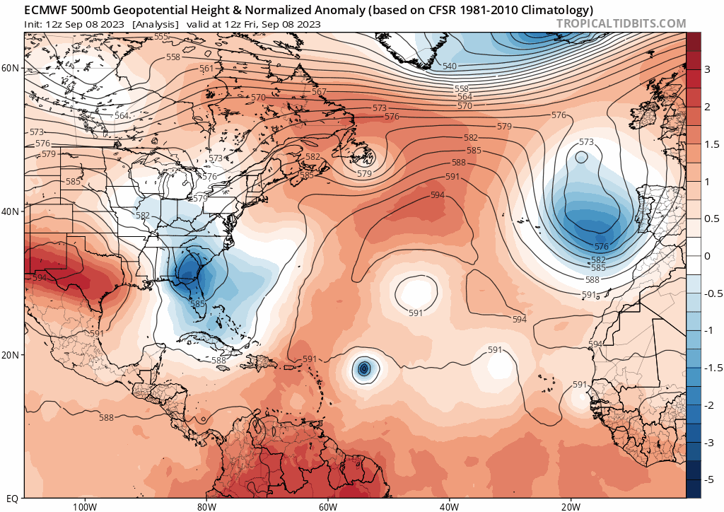
I don’t get an eerie feeling from the Euro at all. It can’t go west towards Florida or the SE US with that huge trough that swings through the Eastern CONUS:
0 likes
Who is online
Users browsing this forum: No registered users and 4 guests