ATL: LEE - Models
Moderator: S2k Moderators
Re: ATL: LEE - Models
trough after trough blasting out of canada will ensure this monster stays away...hopefully far away
0 likes
-
RevanTheJedi96
- Tropical Storm

- Posts: 106
- Joined: Wed Sep 01, 2021 10:40 am
-
gatorcane

- S2K Supporter

- Posts: 23708
- Age: 48
- Joined: Sun Mar 13, 2005 3:54 pm
- Location: Boca Raton, FL
Re: ATL: LEE - Models
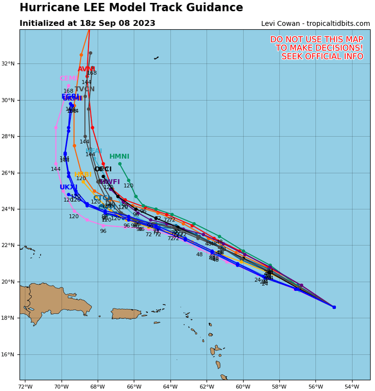
12Z Euro from 120 hours to 216. Looks like Nova Scotia and close pass by Bermuda:
0 likes
Re: ATL: LEE - Models
12z is a bit left of 0z, Margo is way east of 0z though, where the 0z had Lee nudging margot out of the way, 12z has Margo fairly well to the east.
Margot is continuing to really mess with the models at a longer range.

Margot is continuing to really mess with the models at a longer range.
0 likes
-
PavelGaborik10
- Category 1

- Posts: 472
- Joined: Tue Sep 04, 2018 3:23 pm
Re: ATL: LEE - Models
Euro similar track to the CMC and GFS at the end into Nova Scotia.....but a full 24-30 hours slower.
0 likes
Re: ATL: LEE - Models
The 12Z Euro has Lee way down at the latitude of Cape Hatteras at 192 on the way to Nova Scotia it appears. This is ~100 miles SSE of the 0Z run. The 12Z run yesterday for the same time had Lee landfalling in E ME!
0 likes
Personal Forecast Disclaimer:
The posts in this forum are NOT official forecasts and should not be used as such. They are just the opinion of the poster and may or may not be backed by sound meteorological data. They are NOT endorsed by any professional institution or storm2k.org. For official information, please refer to the NHC and NWS products.
The posts in this forum are NOT official forecasts and should not be used as such. They are just the opinion of the poster and may or may not be backed by sound meteorological data. They are NOT endorsed by any professional institution or storm2k.org. For official information, please refer to the NHC and NWS products.
-
RevanTheJedi96
- Tropical Storm
- Posts: 106
- Joined: Wed Sep 01, 2021 10:40 am
Re: ATL: LEE - Models
LarryWx wrote:The 12Z Euro has Lee way down at the latitude of Cape Hatteras at 192 on the way to Nova Scotia it appears. This is ~100 miles SSE of the 0Z run. The 12Z run yesterday for the same time had Lee landfalling in E ME!
Seems a pattern has emerged. Longer time Lee spends down near the Bahamas, further away it ends up from Maine.
0 likes
Re: ATL: LEE - Models
RevanTheJedi96 wrote:LarryWx wrote:The 12Z Euro has Lee way down at the latitude of Cape Hatteras at 192 on the way to Nova Scotia it appears. This is ~100 miles SSE of the 0Z run. The 12Z run yesterday for the same time had Lee landfalling in E ME!
Seems a pattern has emerged. Longer time Lee spends down near the Bahamas, further away it ends up from Maine.
1) Yep
2) The 12Z UKMET is similar to recent runs with it moving N near 70W at 168.
0 likes
Personal Forecast Disclaimer:
The posts in this forum are NOT official forecasts and should not be used as such. They are just the opinion of the poster and may or may not be backed by sound meteorological data. They are NOT endorsed by any professional institution or storm2k.org. For official information, please refer to the NHC and NWS products.
The posts in this forum are NOT official forecasts and should not be used as such. They are just the opinion of the poster and may or may not be backed by sound meteorological data. They are NOT endorsed by any professional institution or storm2k.org. For official information, please refer to the NHC and NWS products.
-
ThunderForce

- Tropical Storm
- Posts: 208
- Age: 26
- Joined: Tue Sep 27, 2022 6:20 pm
- Location: Calhoun County, Florida
Re: ATL: LEE - Models
Operational GFS seems to be a bit more consistent between runs than Operational Euro/ECMWF overall so far. The last eight runs have had Lee start the northward turn between 12z Tuesday 12th and 12z Wednesday 13th.
1 likes
Please refer to the NWS, NHC, SPC or a professional meteorologist for information and decision making during storms.

Re: ATL: LEE - Models
12z HAFS-B shows Lee weakening even more to the 950s, but eventually rebuilds its eyewall, goes through a successful EWRC, and has a secondary peak late Sunday into early Monday. HAFS-A doesn’t weaken it as much and therefore peaks earlier.
1 likes
Irene '11 Sandy '12 Hermine '16 5/15/2018 Derecho Fay '20 Isaias '20 Elsa '21 Henri '21 Ida '21
I am only a meteorology enthusiast who knows a decent amount about tropical cyclones. Look to the professional mets, the NHC, or your local weather office for the best information.
I am only a meteorology enthusiast who knows a decent amount about tropical cyclones. Look to the professional mets, the NHC, or your local weather office for the best information.

Re: ATL: LEE - Models
eps 12z, the sub 900 pressures are back


0 likes
ヤンデレ女が寝取られるているのを見たい!!!
ECMWF ensemble NWPAC plots: https://ecmwfensnwpac.imgbb.com/
Multimodel NWPAC plots: https://multimodelnwpac.imgbb.com/
GFS Ensemble NWPAC plots (16 & 35 day forecast): https://gefsnwpac.imgbb.com/
Plots updated automatically
ECMWF ensemble NWPAC plots: https://ecmwfensnwpac.imgbb.com/
Multimodel NWPAC plots: https://multimodelnwpac.imgbb.com/
GFS Ensemble NWPAC plots (16 & 35 day forecast): https://gefsnwpac.imgbb.com/
Plots updated automatically
-
TomballEd
- Category 5

- Posts: 1258
- Age: 62
- Joined: Wed Aug 16, 2023 4:52 pm
- Location: Spring/Klein area, not Tomball
Re: ATL: LEE - Models
Spacecoast wrote:Perhaps Derek can plot a 10day forecast for Lee, and subject himself to actual verification.
Derek is a private sector met who works on forecasts for energy companies, his MS thesis was on the effects of dry air as shear varied. People are paying for his educated opinions on track and intensity. He won't publish for free what others are charged for. His company may have clients w/ interests in oil offshore Newfoundland.
7 likes
-
gatorcane
- S2K Supporter
- Posts: 23708
- Age: 48
- Joined: Sun Mar 13, 2005 3:54 pm
- Location: Boca Raton, FL
Re: ATL: LEE - Models
18Z Guidance:
Over the next couple of days the NHC track has to start bending to the right as we will be within the 5-day window for the north turn:
Over the next couple of days the NHC track has to start bending to the right as we will be within the 5-day window for the north turn:
0 likes
-
wxman57

- Moderator-Pro Met

- Posts: 23170
- Age: 68
- Joined: Sat Jun 21, 2003 8:06 pm
- Location: Houston, TX (southwest)
Re: ATL: LEE - Models
TomballEd wrote:Spacecoast wrote:Perhaps Derek can plot a 10day forecast for Lee, and subject himself to actual verification.
Derek is a private sector met who works on forecasts for energy companies, his MS thesis was on the effects of dry air as shear varied. People are paying for his educated opinions on track and intensity. He won't publish for free what others are charged for. His company may have clients w/ interests in oil offshore Newfoundland.
Derek is a very good tropical meteorologist. His forecasts, like mine, are verified each year. He can sometimes be a pain in the butt. Kind of reminds me of myself when I was his age. Derek knows a lot about modeling. When I was in school, we barely had computers (1970s).
Speaking of models, here are the new multi-model ensemble runs from 12Z. First the one with no lines:

With lines. Canadian is the west outlier. All head for Nova Scotia.

Super ensemble (all tracks from 4 models):

3 likes
-
Spacecoast

- Category 2

- Posts: 773
- Joined: Thu Aug 31, 2017 2:03 pm
Re: ATL: LEE - Models
TomballEd wrote:Spacecoast wrote:Perhaps Derek can plot a 10day forecast for Lee, and subject himself to actual verification.
Derek is a private sector met who works on forecasts for energy companies, his MS thesis was on the effects of dry air as shear varied. People are paying for his educated opinions on track and intensity. He won't publish for free what others are charged for. His company may have clients w/ interests in oil offshore Newfoundland.
I did not realize this. I stand corrected.
1 likes
-
OuterBanker
- S2K Supporter
- Posts: 1761
- Joined: Wed Feb 26, 2003 10:53 am
- Location: Nags Head, NC
- Contact:
Re: ATL: LEE - Models
wxman57 wrote:TomballEd wrote:Spacecoast wrote:Perhaps Derek can plot a 10day forecast for Lee, and subject himself to actual verification.
Derek is a private sector met who works on forecasts for energy companies, his MS thesis was on the effects of dry air as shear varied. People are paying for his educated opinions on track and intensity. He won't publish for free what others are charged for. His company may have clients w/ interests in oil offshore Newfoundland.
Derek is a very good tropical meteorologist. His forecasts, like mine, are verified each year. He can sometimes be a pain in the butt. Kind of reminds me of myself when I was his age. Derek knows a lot about modeling. When I was in school, we barely had computers (1970s).
Speaking of models, here are the new multi-model ensemble runs from 12Z. First the one with no lines:
http://wxman57.com/images/MMENoLines12Z08.JPG
With lines. Canadian is the west outlier. All head for Nova Scotia.
http://wxman57.com/images/MME12Z08.JPG
Super ensemble (all tracks from 4 models):
http://wxman57.com/images/LSE12Z08.JPG
Wxman. Tomorrow is my birthday. Hint. I had just turned nine when Donna struck a few days later.
2 likes
-
Hypercane_Kyle

- Category 5
- Posts: 3465
- Joined: Sat Mar 07, 2015 7:58 pm
- Location: Cape Canaveral, FL
Re: ATL: LEE - Models
Pretty good consensus this evening that Lee might not have peaked last night. The unexpected shear will begin to lessen as soon as tomorrow morning, where we should see a ramp up in intensity going into Sunday.
1 likes
My posts are my own personal opinion, defer to the National Hurricane Center (NHC) and other NOAA products for decision making during hurricane season.
Re: ATL: LEE - Models
It looks like ~5 (10%) of the 12Z EPS members through hour 240 have a US landfall with all on ME. If there are no more after 240 (probably the case), that would mean a drop from the 14% US landfalls on the 0Z and the 24% on yesterday's 12Z, which had the most.
So, assuming 10% is it for the 12z, here is the running EPS tally of US landfalls:
9/8 12Z: 5 (10%) 9/15-18 (5 ME)
9/8 0Z: 7 (14%) 9/15-17 (6 ME, 1 NY)
9/7 12Z: 12 (24%) 9/15-19 (7 ME, 3 MA, 1 NY, 1 NJ)
9/7 0Z: 10 (20%) 9/15-18 (5 ME, 5 MA)
9/6 12Z: 3 (6%) 9/15-18 (2 ME, 1 MA)
9/6 0Z: 5 (10%)
9/5 12Z: 2 (4%)
9/5 0Z: 4 (8%)
9/4 12Z: 1 (2%)
9/4 0Z: 2 (4%)
Based on the trend of the latest two EPS runs as well as overall model consensus trends, I'm dropping the chance for a US landfall from 20% to 10% and with that mostly for ME. I won't go lower because it is still 10% on the 12Z EPS and the 12Z GEFS also has 10% (3 members hit 9/15-18 with one on each of ME, MA, and RI). To go lower than 10% with any potential hit still 7-10 days away along with the 10% of ensemble members having hits would seem premature.
0 likes
Personal Forecast Disclaimer:
The posts in this forum are NOT official forecasts and should not be used as such. They are just the opinion of the poster and may or may not be backed by sound meteorological data. They are NOT endorsed by any professional institution or storm2k.org. For official information, please refer to the NHC and NWS products.
The posts in this forum are NOT official forecasts and should not be used as such. They are just the opinion of the poster and may or may not be backed by sound meteorological data. They are NOT endorsed by any professional institution or storm2k.org. For official information, please refer to the NHC and NWS products.
-
wxman57
- Moderator-Pro Met
- Posts: 23170
- Age: 68
- Joined: Sat Jun 21, 2003 8:06 pm
- Location: Houston, TX (southwest)
Re: ATL: LEE - Models
OuterBanker wrote:Wxman. Tomorrow is my birthday. Hint. I had just turned nine when Donna struck a few days later.
I'll have Lee send you some big waves a few days after your birthday. Get your surf board ready. If you were born 9 years before Donna (1960), then you are about 6 years older than I am. Maybe just watch the big waves roll in vs. surfing them.
1 likes
Who is online
Users browsing this forum: No registered users and 16 guests