
ATL: FRANKLIN - Models
Moderator: S2k Moderators
-
cycloneye

- Admin

- Posts: 149275
- Age: 69
- Joined: Thu Oct 10, 2002 10:54 am
- Location: San Juan, Puerto Rico
Re: ATL: FRANKLIN - Models
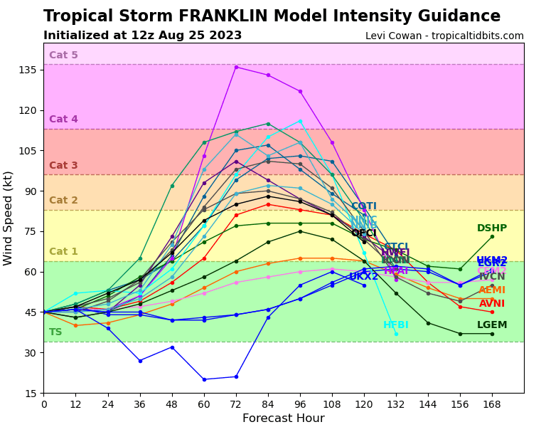
Tight suite st 18z.
0 likes
Visit the Caribbean-Central America Weather Thread where you can find at first post web cams,radars
and observations from Caribbean basin members Click Here
and observations from Caribbean basin members Click Here
-
Spacecoast

- Category 2

- Posts: 773
- Joined: Thu Aug 31, 2017 2:03 pm

Re: ATL: FRANKLIN - Models
Something here looks out of place.
https://www.tropicaltidbits.com/storminfo/08L_intensity_latest.png
https://www.tropicaltidbits.com/storminfo/08L_intensity_latest.png
0 likes

Re: ATL: FRANKLIN - Models
"Two of these are not like the others" 
0 likes
I'm not a meteorologist, I'm an electronics engineer. While I can probably fix your toaster oven, you're not going to learn about storms from me!
New Mexico had no hurricanes. Then I moved to NC right before Fran.....
New Mexico had no hurricanes. Then I moved to NC right before Fran.....
-
cycloneye
- Admin
- Posts: 149275
- Age: 69
- Joined: Thu Oct 10, 2002 10:54 am
- Location: San Juan, Puerto Rico
Re: ATL: FRANKLIN - Models
0 likes
Visit the Caribbean-Central America Weather Thread where you can find at first post web cams,radars
and observations from Caribbean basin members Click Here
and observations from Caribbean basin members Click Here

Re: ATL: FRANKLIN - Models
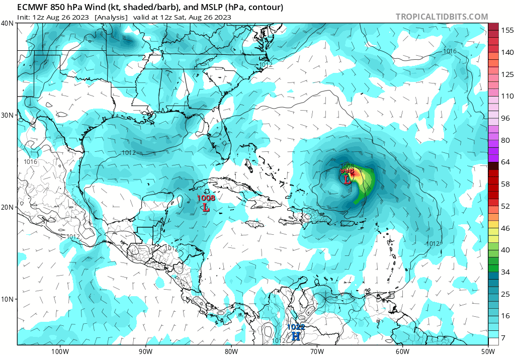
Pangu, an AI Weather Model, has it hitting or coming very close to New England
https://charts.ecmwf.int/products/pangu ... 2308300600
https://twitter.com/stormchaserjs/status/1694263939637359036
https://charts.ecmwf.int/products/pangu ... 2308300600
https://twitter.com/stormchaserjs/status/1694263939637359036
0 likes
-
cycloneye
- Admin
- Posts: 149275
- Age: 69
- Joined: Thu Oct 10, 2002 10:54 am
- Location: San Juan, Puerto Rico
Re: ATL: FRANKLIN - Models
HAFS-A goes up to cat 4.

1 likes
Visit the Caribbean-Central America Weather Thread where you can find at first post web cams,radars
and observations from Caribbean basin members Click Here
and observations from Caribbean basin members Click Here
-
cycloneye
- Admin
- Posts: 149275
- Age: 69
- Joined: Thu Oct 10, 2002 10:54 am
- Location: San Juan, Puerto Rico
Re: ATL: FRANKLIN - Models
Looks like NHC will go up to 100 kt as new peak.

0 likes
Visit the Caribbean-Central America Weather Thread where you can find at first post web cams,radars
and observations from Caribbean basin members Click Here
and observations from Caribbean basin members Click Here

Re: ATL: FRANKLIN - Models
NHC has been quite aggressive in the intensity forecast for Franklin, and has noted several times that their forecast lies at the upper end of the guidance. Which seems unusual as they're typically much more conservative with intensity.
1 likes
TC naming lists: retirements and intensity
Most aggressive Advisory #1's in North Atlantic (cr. kevin for starting the list)
Most aggressive Advisory #1's in North Atlantic (cr. kevin for starting the list)
-
cycloneye
- Admin
- Posts: 149275
- Age: 69
- Joined: Thu Oct 10, 2002 10:54 am
- Location: San Juan, Puerto Rico
Re: ATL: FRANKLIN - Models
Teban54 wrote:
NHC has been quite aggressive in the intensity forecast for Franklin, and has noted several times that their forecast lies at the upper end of the guidance. Which seems unusual as they're typically much more conservative with intensity.
They did not go up to cat 3 at 11 AM.
0 likes
Visit the Caribbean-Central America Weather Thread where you can find at first post web cams,radars
and observations from Caribbean basin members Click Here
and observations from Caribbean basin members Click Here


Re: ATL: FRANKLIN - Models
The 12z HAFS-A is overkill. It has a 145 kt/918 mbar Cat 5 on Monday morning. A potential OTS Cat 5 would be cool (Franklin might miss both Bermuda and Atlantic Canada), but it’s incredibly unlikely. I think a mid 4 is the highest ceiling.
1 likes
Irene '11 Sandy '12 Hermine '16 5/15/2018 Derecho Fay '20 Isaias '20 Elsa '21 Henri '21 Ida '21
I am only a meteorology enthusiast who knows a decent amount about tropical cyclones. Look to the professional mets, the NHC, or your local weather office for the best information.
I am only a meteorology enthusiast who knows a decent amount about tropical cyclones. Look to the professional mets, the NHC, or your local weather office for the best information.

Re: ATL: FRANKLIN - Models
Ehmm HAFS can you calm down a bit... 
(Already mentioned above but here's an image for the archive)

(Already mentioned above but here's an image for the archive)
0 likes
Re: ATL: FRANKLIN - Models
Looks like intensity guidance has been on a rise with more models showing a Cat 3 peak:
0 likes
TC naming lists: retirements and intensity
Most aggressive Advisory #1's in North Atlantic (cr. kevin for starting the list)
Most aggressive Advisory #1's in North Atlantic (cr. kevin for starting the list)
-
ElectricStorm

- Category 5

- Posts: 5139
- Age: 25
- Joined: Tue Aug 13, 2019 11:23 pm
- Location: Norman, OK
Re: ATL: FRANKLIN - Models
0z hurricane models are pretty wild:
HWRF peaks at 949mb/100kts (weird seeing the HWRF the weakest of the four)
HMON 931mb/around 125kts
HAFS-A has a 130kt/932mb Cat 4
HAFS-B has a 140-145kt/924mb Cat 5
I don't think this will reach Cat 5 but it does seem like Franklin's potential peak intensity is getting a little higher
HWRF peaks at 949mb/100kts (weird seeing the HWRF the weakest of the four)
HMON 931mb/around 125kts
HAFS-A has a 130kt/932mb Cat 4
HAFS-B has a 140-145kt/924mb Cat 5
I don't think this will reach Cat 5 but it does seem like Franklin's potential peak intensity is getting a little higher
0 likes
B.S Meteorology, University of Oklahoma '25
Please refer to the NHC, NWS, or SPC for official information.
Please refer to the NHC, NWS, or SPC for official information.
-
USTropics
- Professional-Met

- Posts: 2737
- Joined: Sun Aug 12, 2007 3:45 am
- Location: Florida State University
Re: ATL: FRANKLIN - Models
Will be interesting to see the 12z ECMWF ensembles for Franklin later today. The more eastward progression yesterday/this morning by the LLC has created a noticeable trend in the GFS ensembles, with ~40% of members now showing this could potentially bring impacts to Bermuda:

0 likes
-
Hybridstorm_November2001

- S2K Supporter

- Posts: 2817
- Joined: Sat Aug 21, 2004 2:50 pm
- Location: SW New Brunswick, Canada
- Contact:
Re: ATL: FRANKLIN - Models
USTropics wrote:Will be interesting to see the 12z ECMWF ensembles for Franklin later today. The more eastward progression yesterday/this morning by the LLC has created a noticeable trend in the GFS ensembles, with ~40% of members now showing this could potentially bring impacts to Bermuda
Indeed, the trend eastward has been so pronounced I will stop tracking Franklin on my Weather Blog after the update later today, I think it is nigh impossible that Franklin will threaten the NE (NYC to Nova Scotia) with anything more than high surf. Bermuda, however, could very well be under the gun.
0 likes
Re: ATL: FRANKLIN - Models
0z Icon, Franklin hits Bermuda. (TD10/Idalia does too soon after)

0 likes
Who is online
Users browsing this forum: No registered users and 147 guests