Suptropical Storm 1 (Upgraded in Pre-season Reanalysis)
Moderator: S2k Moderators
-
InfernoFlameCat

- Category 5

- Posts: 1966
- Age: 21
- Joined: Mon Dec 14, 2020 10:52 am
- Location: Buford, GA
Re: ATL: INVEST 90L - Discussion
As long as the atmosphere cools above the storm as fast as the waters do, the storm will continue to get energy from the ocean through latent heat.
3 likes
I am by no means a professional. DO NOT look at my forecasts for official information or make decisions based on what I post.
Goal: to become a registered expert over tropical and subtropical cyclones.
Goal: to become a registered expert over tropical and subtropical cyclones.
-
InfernoFlameCat
- Category 5
- Posts: 1966
- Age: 21
- Joined: Mon Dec 14, 2020 10:52 am
- Location: Buford, GA
Re: ATL: INVEST 90L - Discussion
I can’t believe we are discussing a system like this on whether it will be named or not. Instead, we should be debating whether it is a hurricane or not.
5 likes
I am by no means a professional. DO NOT look at my forecasts for official information or make decisions based on what I post.
Goal: to become a registered expert over tropical and subtropical cyclones.
Goal: to become a registered expert over tropical and subtropical cyclones.
-
Sciencerocks
- Category 5
- Posts: 7282
- Age: 38
- Joined: Thu Jul 06, 2017 1:51 am
Re: ATL: INVEST 90L - Discussion
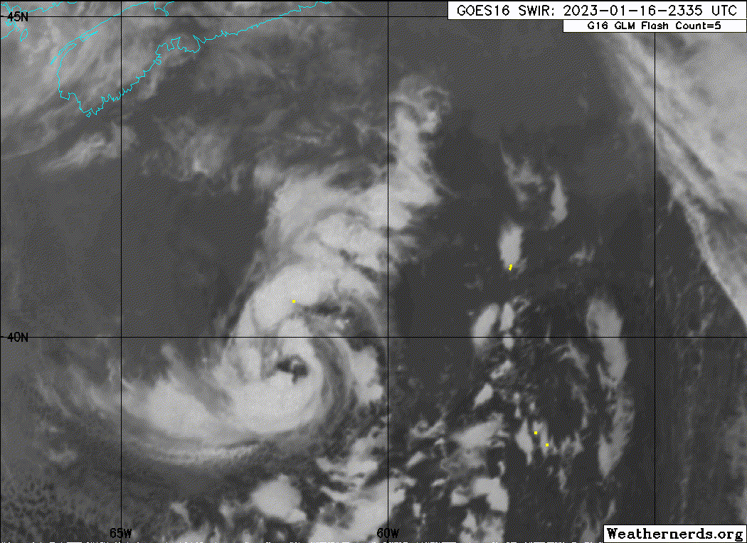
If I had a gun to my head and I was forced to decide. Well, I'd say 65 knot hurricane for this. The eyewall is pretty complete, convection is decent and it reminds me of systems that are 65-75 knots that I've tracked in the pass.
I'll add that this is better looking then Nicole ever was.
I'll add that this is better looking then Nicole ever was.
Last edited by Sciencerocks on Mon Jan 16, 2023 8:29 pm, edited 1 time in total.
3 likes
-
cycloneye

- Admin

- Posts: 139046
- Age: 67
- Joined: Thu Oct 10, 2002 10:54 am
- Location: San Juan, Puerto Rico
Re: ATL: INVEST 90L - Discussion
0 likes
Visit the Caribbean-Central America Weather Thread where you can find at first post web cams,radars
and observations from Caribbean basin members Click Here
and observations from Caribbean basin members Click Here


-
Sciencerocks
- Category 5
- Posts: 7282
- Age: 38
- Joined: Thu Jul 06, 2017 1:51 am
Re: ATL: INVEST 90L - Discussion
I'd argue that it has strengthen to 70 and it is possibly as high as 75 knots. If you're in canada get ready for more then just light damage.There's now no question in my mind that it is now a hurricane.
Last edited by Sciencerocks on Mon Jan 16, 2023 9:07 pm, edited 1 time in total.
0 likes
-
galaxy401

- Category 5
- Posts: 2299
- Age: 28
- Joined: Sat Aug 25, 2012 9:04 pm
- Location: Casa Grande, Arizona
Re: ATL: INVEST 90L - Discussion
Haven't been on for awhile and now I see this system. One of the best unnamed storms I've seen. You really have to wonder for those in the NHC whether to finally just floor it and upgrade it or keep it on stasis for the time being. Especially since it will make landfall (though much weaker by then).
0 likes
Got my eyes on moving right into Hurricane Alley: Florida.
-
Category5Kaiju

- Category 5
- Posts: 3352
- Age: 22
- Joined: Thu Dec 24, 2020 12:45 pm
- Location: Seattle
Re: ATL: INVEST 90L - Discussion
So has the NHC developed a new rule for naming storms? Especially off-season? I'm still kind of lost here as I was under the assumption that even if we're in off-season, if there's an Atlantic storm that meets all the criteria for a TS or SS that it would almost certainly be tracked and receive a name?
3 likes
Unless explicitly stated, all information covered in my posts is based on my opinions and observations. Please refer to a professional meteorologist or an accredited weather research agency otherwise, especially if serious decisions must be made in the event of a potentially life-threatening tropical storm or hurricane.
-
cycloneye
- Admin
- Posts: 139046
- Age: 67
- Joined: Thu Oct 10, 2002 10:54 am
- Location: San Juan, Puerto Rico
Re: ATL: INVEST 90L - Discussion
0 likes
Visit the Caribbean-Central America Weather Thread where you can find at first post web cams,radars
and observations from Caribbean basin members Click Here
and observations from Caribbean basin members Click Here
-
CrazyC83
- Professional-Met

- Posts: 33393
- Joined: Tue Mar 07, 2006 11:57 pm
- Location: Deep South, for the first time!
Re: ATL: INVEST 90L - Discussion
I'm curious what the NHC is thinking with this now.
One other thought: the 983 mb pressure seems quite low given the small size of the storm. Maybe that's because of being embedded in another cyclone's circulation.
One other thought: the 983 mb pressure seems quite low given the small size of the storm. Maybe that's because of being embedded in another cyclone's circulation.
2 likes
Re: ATL: INVEST 90L - Discussion
CrazyC83 wrote:I'm curious what the NHC is thinking with this now.
One other thought: the 983 mb pressure seems quite low given the small size of the storm. Maybe that's because of being embedded in another cyclone's circulation.
I am very curious as well. It undeniably looks better than ever, but it doesn't seem likely we get an advisory this cycle either... unless they rush one out? What a confusing case.
0 likes
Re: ATL: INVEST 90L - Discussion
Considerable amount of convection in the -55C to -60C range with 13C waters looming close by. 

0 likes
-
InfernoFlameCat
- Category 5
- Posts: 1966
- Age: 21
- Joined: Mon Dec 14, 2020 10:52 am
- Location: Buford, GA
Re: ATL: INVEST 90L - Discussion
I don’t get it. Why isn’t this named! I mean… this sets new precedent. Like how could this storm, which looks better than 90% of tropical storms, possibly be unnamed?
2 likes
I am by no means a professional. DO NOT look at my forecasts for official information or make decisions based on what I post.
Goal: to become a registered expert over tropical and subtropical cyclones.
Goal: to become a registered expert over tropical and subtropical cyclones.
-
Sciencerocks
- Category 5
- Posts: 7282
- Age: 38
- Joined: Thu Jul 06, 2017 1:51 am
Re: ATL: INVEST 90L - Discussion
InfernoFlameCat wrote:I don’t get it. Why isn’t this named! I mean… this sets new precedent. Like how could this storm, which looks better than 90% of tropical storms, possibly be unnamed?
Not within a tropical airmass. Idk if you are in SE US or Florida now to feel it, but the airmass this warm seclusion is embedded in is definitely a cold one. Even the "warm" air forming the seclusion is only around 60 degrees F. Forgetting for a second about the warm core/cold core details, it just goes against intuition and precedent to say there is a tropical cyclone off the New England coast when the cyclone is not even a warm weather system. It's similar to the reason medicanes and polar lows are not classified as tropical.
Why does it have to receive a name and be recognized as something that it isn't? it is an interesting system to follow regardless.
Last edited by Dean_175 on Mon Jan 16, 2023 10:38 pm, edited 3 times in total.
1 likes
All posts by Dean_175 are NOT official forecasts and should not be used as such. They are just the opinion of the poster and may or may not be backed by sound meteorological data. They are NOT endorsed by any professional institution or storm2k.org. For official information, please refer to the NHC and NWS products.
-
InfernoFlameCat
- Category 5
- Posts: 1966
- Age: 21
- Joined: Mon Dec 14, 2020 10:52 am
- Location: Buford, GA
Re: ATL: INVEST 90L - Discussion
It looks better. Not more tropical. It does not have the outflow a true tropical system has. But it’s very well organized with tropical characteristics.
0 likes
I am by no means a professional. DO NOT look at my forecasts for official information or make decisions based on what I post.
Goal: to become a registered expert over tropical and subtropical cyclones.
Goal: to become a registered expert over tropical and subtropical cyclones.
-
Sciencerocks
- Category 5
- Posts: 7282
- Age: 38
- Joined: Thu Jul 06, 2017 1:51 am
Re: ATL: INVEST 90L - Discussion
This is stronger then nicole and more deserving of the hurricane title.
I don't know how anyone could look at that satellite and say polar low? I mean why?
I don't know how anyone could look at that satellite and say polar low? I mean why?
5 likes
Re: ATL: INVEST 90L - Discussion
Looks like 90L is moving into the 13C isotherm now; cloudtops seem to be warming as well, at least presently. Should be downhill from here, luckily for NS.
0 likes


Re: ATL: INVEST 90L - Discussion
Tough call. If this was early December it would be most certainly a sub tropical storm and I do believe it will be classified as one after the fact. At least we save a name...
0 likes
Re: ATL: INVEST 90L - Discussion
Category5Kaiju wrote:So has the NHC developed a new rule for naming storms? Especially off-season? I'm still kind of lost here as I was under the assumption that even if we're in off-season, if there's an Atlantic storm that meets all the criteria for a TS or SS that it would almost certainly be tracked and receive a name?
My amateur opinion is the only reason why its not named is because its the middle of January. The NHC was a bit late classifying as an invest also, I was surprised this did not happen Saturday evening...
I do think post season analysis will upgrade this system to a sub tropical storm
0 likes
Who is online
Users browsing this forum: No registered users and 10 guests