
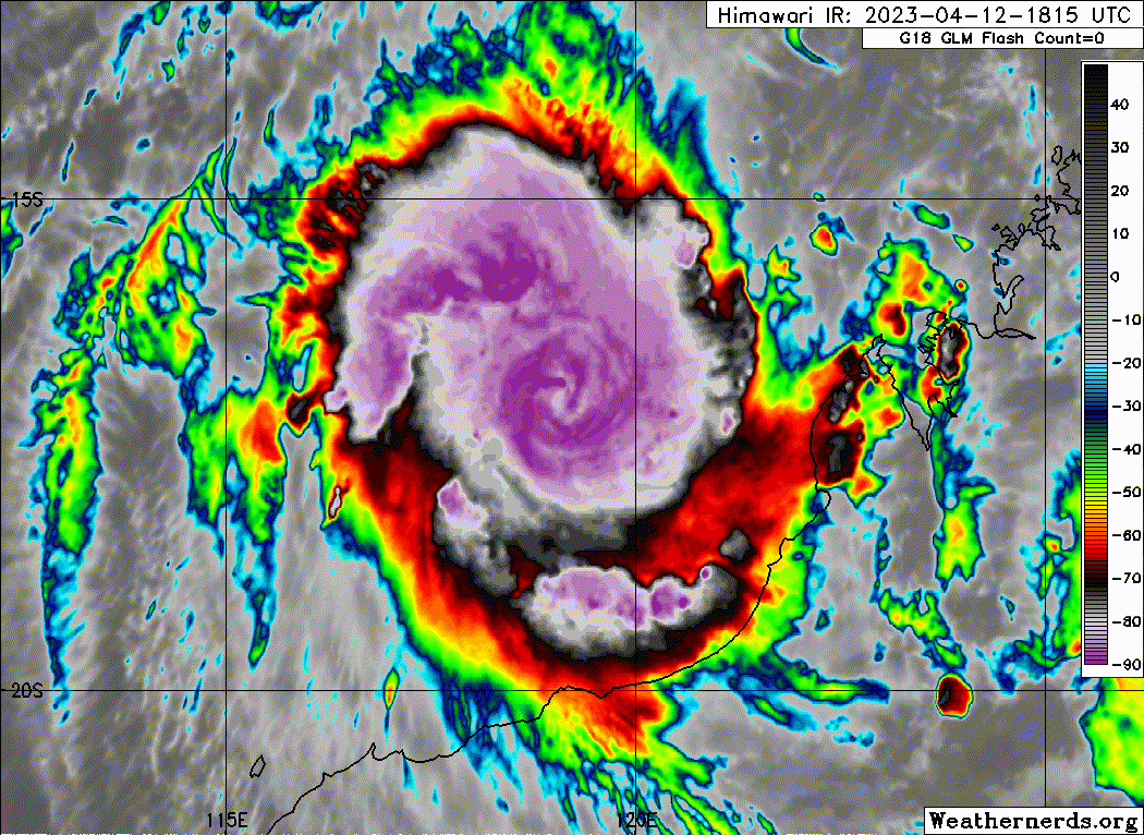
Looks like a CCC structure, which suggests the core is still damaged from the last few days of shear. There seems to still be a decent bit of shear slightly pushing on the eastern side of the CCC.
SIO: ILSA - Post-Tropical
Moderator: S2k Moderators
Re: SIO: ILSA - Tropical Cyclone
Looks like a CCC structure, which suggests the core is still damaged from the last few days of shear. There seems to still be a decent bit of shear slightly pushing on the eastern side of the CCC.
0 likes
Irene '11 Sandy '12 Hermine '16 5/15/2018 Derecho Fay '20 Isaias '20 Elsa '21 Henri '21 Ida '21
I am only a meteorology enthusiast who knows a decent amount about tropical cyclones. Look to the professional mets, the NHC, or your local weather office for the best information.
I am only a meteorology enthusiast who knows a decent amount about tropical cyclones. Look to the professional mets, the NHC, or your local weather office for the best information.
-
cycloneye

- Admin

- Posts: 139008
- Age: 67
- Joined: Thu Oct 10, 2002 10:54 am
- Location: San Juan, Puerto Rico
Re: SIO: ILSA - Tropical Cyclone
0 likes
Visit the Caribbean-Central America Weather Thread where you can find at first post web cams,radars
and observations from Caribbean basin members Click Here
and observations from Caribbean basin members Click Here
-
cycloneye
- Admin
- Posts: 139008
- Age: 67
- Joined: Thu Oct 10, 2002 10:54 am
- Location: San Juan, Puerto Rico
Re: SIO: ILSA - Tropical Cyclone
TROPICAL CYCLONE TECHNICAL BULLETIN: AUSTRALIA - WESTERN REGION
Issued by AUSTRALIAN BUREAU OF METEOROLOGY TROPICAL CYCLONE WARNING CENTRE
at: 1932 UTC 11/04/2023
Name: Tropical Cyclone Ilsa
Identifier: 23U
Data At: 1800 UTC
Latitude: 15.5S
Longitude: 120.2E
Location Accuracy: within 30nm (55 km)
Movement Towards: southwest (228 deg)
Speed of Movement: 5 knots (8 km/h)
Maximum 10-Minute Wind: 55 knots (100 km/h)
Maximum 3-Second Wind Gust: 75 knots (140 km/h)
Central Pressure: 985 hPa
Radius of 34-knot winds NE quadrant: 60 nm (110 km)
Radius of 34-knot winds SE quadrant: 80 nm (150 km)
Radius of 34-knot winds SW quadrant: 80 nm (150 km)
Radius of 34-knot winds NW quadrant: 80 nm (150 km)
Radius of 48-knot winds NE quadrant: 35 nm (65 km)
Radius of 48-knot winds SE quadrant: 35 nm (65 km)
Radius of 48-knot winds SW quadrant: 35 nm (65 km)
Radius of 48-knot winds NW quadrant: 35 nm (65 km)
Radius of 64-knot winds: nm ( km)
Radius of Maximum Winds: 20 nm (35 km)
Dvorak Intensity Code: T3.5/4.0/D1.0/24HRS STT:S0.0/06HRS
Pressure of outermost isobar: 1004 hPa
Radius of outermost closed isobar: 150 nm (280 km)
FORECAST DATA
Date/Time : Location : Loc. Accuracy: Max Wind : Central Pressure
(UTC) : degrees : nm (km): knots(km/h): hPa
+06: 12/0000: 15.9S 120.0E: 045 (085): 065 (120): 976
+12: 12/0600: 16.3S 119.8E: 055 (105): 070 (130): 972
+18: 12/1200: 16.7S 119.5E: 065 (115): 080 (150): 963
+24: 12/1800: 17.1S 119.3E: 070 (130): 085 (155): 959
+36: 13/0600: 18.3S 119.1E: 085 (155): 095 (175): 948
+48: 13/1800: 19.7S 120.2E: 105 (195): 100 (185): 944
+60: 14/0600: 21.2S 123.0E: 125 (230): 055 (100): 983
+72: 14/1800: 22.2S 127.9E: 150 (280): 040 (075): 995
+96: 15/1800: 23.6S 139.0E: 165 (310): 030 (055): 1000
+120: 16/1800: : : :
REMARKS:
Deep convection continues to develop over Tropical Cyclone Ilsa, with rapid
intensification likely over the next 24 hours.
Good confidence in the position of 23U with recent microwave pass from ATMS
sensor and synthetic aperture radar (SAR) data from RCM3. Intensity is set at
55 knots based on Dvorak CI of 4.0 and ADT of 61 knots (1-min mean).
Dvorak analysis of DT = 3.5, MET = 3.5, PT = 3.5 and D 24 hour trend. CI
maintained at 4.0. Objective guidance agrees, with ADT CI of 3.8 (NESDIS and
CIMSS), SATCON at 60 knots and Open-AIIR at 60 to 65 knots (1-min). SAR data
from 1015 UTC RCM3 pass suggests mean winds may be as high as 60 to 65 knots,
however, there is low confidence in this data at this stage.
Wind shear has decreased over 23U and at 1800 UTC, CIMSS upper wind analysis
has analysed approximately 12 knots of shear. The system should begin a rapid
development cycle with favourable shear, high mid-level moisture and warm SSTs
(30+ degrees Celsius). CIMSS AI-RI guidance suggests at high probability of a
30 to 35 knot increase in intensity over the next 24 hours.
Upper divergence to the south increases and the system is forecast to develop
into a severe tropical cyclone Wednesday morning, likely reaching a category 4
system during Thursday. 23U is forecast to move southwest parallel to and
offshore from the Kimberley coast during Wednesday before turning south and
then southeast during Thursday, with a coastal crossing likely later Thursday
or early Friday between Port Hedland and Broome.
The forecast track is based on a standard consensus of numerical weather
prediction (NWP) models. This track is consistent with upper-air analyses which
show a mid-upper ridge over the NT and an approaching upper trough over
southern WA. There is relatively high confidence in this forecast track. In the
long-term, 23U is forecast to move over central Australia and begin a
transition to a deep, sub-tropical system as it interacts with the sub-tropical
jet.
Intensity forecasts are based on a rapid rate of development prior to landfall,
with a landfall intensity of 100 knots (Category 4). This is consistent with a
consensus of NWP models. 23U is forecast to remain a strong system as it moves
inland on Friday.
0 likes
Visit the Caribbean-Central America Weather Thread where you can find at first post web cams,radars
and observations from Caribbean basin members Click Here
and observations from Caribbean basin members Click Here
-
cycloneye
- Admin
- Posts: 139008
- Age: 67
- Joined: Thu Oct 10, 2002 10:54 am
- Location: San Juan, Puerto Rico
Re: SIO: ILSA - Tropical Cyclone
TROPICAL CYCLONE TECHNICAL BULLETIN: AUSTRALIA - WESTERN REGION
Issued by AUSTRALIAN BUREAU OF METEOROLOGY TROPICAL CYCLONE WARNING CENTRE
at: 0127 UTC 12/04/2023
Name: Tropical Cyclone Ilsa
Identifier: 23U
Data At: 0000 UTC
Latitude: 15.7S
Longitude: 119.8E
Location Accuracy: within 25nm (45 km)
Movement Towards: southwest (235 deg)
Speed of Movement: 4 knots (7 km/h)
Maximum 10-Minute Wind: 60 knots (110 km/h)
Maximum 3-Second Wind Gust: 85 knots (155 km/h)
Central Pressure: 981 hPa
Radius of 34-knot winds NE quadrant: 60 nm (110 km)
Radius of 34-knot winds SE quadrant: 80 nm (150 km)
Radius of 34-knot winds SW quadrant: 80 nm (150 km)
Radius of 34-knot winds NW quadrant: 80 nm (150 km)
Radius of 48-knot winds NE quadrant: 35 nm (65 km)
Radius of 48-knot winds SE quadrant: 35 nm (65 km)
Radius of 48-knot winds SW quadrant: 35 nm (65 km)
Radius of 48-knot winds NW quadrant: 35 nm (65 km)
Radius of 64-knot winds: nm ( km)
Radius of Maximum Winds: 15 nm (30 km)
Dvorak Intensity Code: T4.0/4.0/D1.5/24HRS STT:S0.5/6HRS
Pressure of outermost isobar: 1006 hPa
Radius of outermost closed isobar: 180 nm (335 km)
FORECAST DATA
Date/Time : Location : Loc. Accuracy: Max Wind : Central Pressure
(UTC) : degrees : nm (km): knots(km/h): hPa
+06: 12/0600: 16.1S 119.7E: 040 (075): 070 (130): 974
+12: 12/1200: 16.5S 119.4E: 050 (095): 080 (150): 965
+18: 12/1800: 16.9S 119.2E: 055 (105): 085 (155): 961
+24: 13/0000: 17.4S 119.0E: 065 (120): 095 (175): 952
+36: 13/1200: 18.8S 119.4E: 075 (135): 100 (185): 945
+48: 14/0000: 20.2S 121.4E: 100 (185): 075 (140): 969
+60: 14/1200: 21.5S 125.3E: 125 (230): 045 (085): 993
+72: 15/0000: 22.4S 130.8E: 150 (280): 035 (065): 1001
+96: 16/0000: : : :
+120: 17/0000: : : :
REMARKS:
Tropical Cyclone Ilsa continues to develop, and a rapid intensification likely
over the next 24 hours.
Moderate to good confidence in the position of 23U with recent microwave pass
and the slow movement of the system.
Dvorak analysis of DT = 4.5, MET/PT = 4.0, and D 24 hour trend. FT/CI at 4.0.
Objective guidance, with ADT CI of 4.4 CIMSS and 4.0 NESDIS, SATCON at 69
knots, AiDT 71 knots, and Open-AIIR at 55 to 60 knots (1-min). SMOS 2218UTC
has 50-64 knots near the centre. Intensity is set at 60 knots based on Dvorak
CI of 4.0.
Wind shear remains low over 23U and at 0000 UTC CIMSS upper wind analysis has
analysed approximately 10 knots of shear. The system should begin a rapid
development cycle with favourable shear, high mid-level moisture and warm SSTs
(30+ degrees Celsius). CIMSS AI-RI guidance suggests at high probability of a
30 to 35 knot increase in intensity over the next 24 hours. Intensity forecasts
are based on a rapid rate of development prior to landfall, with a landfall
intensity of 105 knots (Category 4). This is consistent with a consensus of NWP
models. 23U is forecast to remain a strong system as it moves inland on Friday.
The forecast track is based on a standard consensus of numerical weather
prediction (NWP) models. This track is consistent with upper-air analyses which
show a mid-upper ridge over the NT and an approaching upper trough over
southern WA. There is relatively high confidence in this forecast track. Ilsa
is forecast to move southwest parallel to and offshore from the Kimberley coast
during Wednesday before turning south and then southeast during Thursday, with
a coastal crossing likely later Thursday or early Friday between Port Hedland
and Broome, most likely in vicinity of Wallal Downs. In the long-term, Ilsa is
forecast to move over central Australia and begin a transition to a deep,
sub-tropical system as it interacts with the sub-tropical jet.
0 likes
Visit the Caribbean-Central America Weather Thread where you can find at first post web cams,radars
and observations from Caribbean basin members Click Here
and observations from Caribbean basin members Click Here
-
Meteophile
- Tropical Depression

- Posts: 50
- Joined: Tue May 12, 2020 3:38 pm
Re: SIO: ILSA - Tropical Cyclone
I hope they will put the mesoscale satellite imagery on this storm before it gets hagibis - like (there seems to be a huge risk it happens).
0 likes
-
cycloneye
- Admin
- Posts: 139008
- Age: 67
- Joined: Thu Oct 10, 2002 10:54 am
- Location: San Juan, Puerto Rico
Re: SIO: ILSA - Severe Tropical Cyclone
TROPICAL CYCLONE TECHNICAL BULLETIN: AUSTRALIA - WESTERN REGION
Issued by AUSTRALIAN BUREAU OF METEOROLOGY TROPICAL CYCLONE WARNING CENTRE
at: 0659 UTC 12/04/2023
Name: Severe Tropical Cyclone Ilsa
Identifier: 23U
Data At: 0600 UTC
Latitude: 15.9S
Longitude: 119.5E
Location Accuracy: within 25nm (45 km)
Movement Towards: west southwest (238 deg)
Speed of Movement: 4 knots (7 km/h)
Maximum 10-Minute Wind: 65 knots (120 km/h)
Maximum 3-Second Wind Gust: 90 knots (165 km/h)
Central Pressure: 973 hPa
Radius of 34-knot winds NE quadrant: 60 nm (110 km)
Radius of 34-knot winds SE quadrant: 60 nm (110 km)
Radius of 34-knot winds SW quadrant: 80 nm (150 km)
Radius of 34-knot winds NW quadrant: 80 nm (150 km)
Radius of 48-knot winds NE quadrant: 35 nm (65 km)
Radius of 48-knot winds SE quadrant: 35 nm (65 km)
Radius of 48-knot winds SW quadrant: 35 nm (65 km)
Radius of 48-knot winds NW quadrant: 35 nm (65 km)
Radius of 64-knot winds: 25 nm (45 km)
Radius of Maximum Winds: 10 nm (20 km)
Dvorak Intensity Code: T4.5/4.5/D1.5/24HRS STT:S0.5/6HRS
Pressure of outermost isobar: 1004 hPa
Radius of outermost closed isobar: 180 nm (335 km)
FORECAST DATA
Date/Time : Location : Loc. Accuracy: Max Wind : Central Pressure
(UTC) : degrees : nm (km): knots(km/h): hPa
+06: 12/1200: 16.2S 119.2E: 040 (080): 080 (150): 965
+12: 12/1800: 16.7S 119.0E: 050 (095): 085 (155): 961
+18: 13/0000: 17.2S 118.8E: 055 (105): 095 (175): 952
+24: 13/0600: 18.1S 118.9E: 065 (115): 100 (185): 945
+36: 13/1800: 19.7S 120.1E: 075 (140): 105 (195): 941
+48: 14/0600: 21.2S 123.1E: 095 (175): 055 (100): 985
+60: 14/1800: 22.3S 127.9E: 120 (220): 035 (065): 1000
+72: 15/0600: 23.0S 134.1E: 160 (290): 030 (055): 1004
+96: 16/0600: : : :
+120: 17/0600: : : :
REMARKS:
Severe Tropical Cyclone Ilsa is now a Category 3 system
Moderate to good confidence in the position of 23U with recent microwave pass
and the slow movement of the system.
Dvorak analysis of DT = 4.5 with embedded centre pattern, MET/PT = 4.0, and D
24 hour trend. FT/CI based on DT at 4.5. Objective guidance, with ADT CI of 4.7
CIMSS and 3.7 NESDIS, SATCON at 70 knots, AiDT 78 knots, and Open-AIIR
ranging between 65 to 80 knots (1-min). Intensity is set at 65 knots based on
Dvorak CI of 4.5 and confirming objective guidance.
Wind shear remains low over 23U and at 0000 UTC CIMSS upper wind analysis has
analysed approximately 10 knots of shear. The system is in rapid development
cycle with favourable shear, high mid-level moisture and warm SSTs (30+ degrees
Celsius). CIMSS AI-RI guidance suggests at high probability of a 30 to 35 knot
increase in intensity over the next 24 hours. Intensity forecasts are based on
a rapid rate of development prior to landfall, with a landfall intensity of 105
knots (Category 4). This is consistent with a consensus of NWP models. 23U is
forecast to remain a strong system as it moves inland on Friday.
Some of the latest guidance has moved the system track slightly further west,
however the analysis position varies from model guidance. The forecast does
accommodate a slightly further west track. Generally there is still relatively
high confidence in this forecast track. Ilsa is forecast to move southwest
parallel to and offshore from the Kimberley coast during Wednesday before
turning south and then southeast during Thursday, with a coastal crossing
likely later Thursday or early Friday east of Port Hedland, most likely in
vicinity of Wallal Downs. In the long-term, Ilsa is forecast to move over
central Australia and begin a transition to a deep, sub-tropical system as it
interacts with the sub-tropical jet.
0 likes
Visit the Caribbean-Central America Weather Thread where you can find at first post web cams,radars
and observations from Caribbean basin members Click Here
and observations from Caribbean basin members Click Here
-
cycloneye
- Admin
- Posts: 139008
- Age: 67
- Joined: Thu Oct 10, 2002 10:54 am
- Location: San Juan, Puerto Rico
Re: SIO: ILSA - Severe Tropical Cyclone
TROPICAL CYCLONE TECHNICAL BULLETIN: AUSTRALIA - WESTERN REGION
Issued by AUSTRALIAN BUREAU OF METEOROLOGY TROPICAL CYCLONE WARNING CENTRE
at: 1322 UTC 12/04/2023
Name: Severe Tropical Cyclone Ilsa
Identifier: 23U
Data At: 1200 UTC
Latitude: 16.6S
Longitude: 119.7E
Location Accuracy: within 15nm (30 km)
Movement Towards: south (191 deg)
Speed of Movement: 5 knots (9 km/h)
Maximum 10-Minute Wind: 80 knots (150 km/h)
Maximum 3-Second Wind Gust: 110 knots (205 km/h)
Central Pressure: 964 hPa
Radius of 34-knot winds NE quadrant: 60 nm (110 km)
Radius of 34-knot winds SE quadrant: 60 nm (110 km)
Radius of 34-knot winds SW quadrant: 45 nm (85 km)
Radius of 34-knot winds NW quadrant: 60 nm (110 km)
Radius of 48-knot winds NE quadrant: 35 nm (65 km)
Radius of 48-knot winds SE quadrant: 35 nm (65 km)
Radius of 48-knot winds SW quadrant: 35 nm (65 km)
Radius of 48-knot winds NW quadrant: 35 nm (65 km)
Radius of 64-knot winds: 25 nm (45 km)
Radius of Maximum Winds: 10 nm (20 km)
Dvorak Intensity Code: T5.0/5.0/D1.0/24HRS STT:D0.5/06HRS
Pressure of outermost isobar: 1004 hPa
Radius of outermost closed isobar: 180 nm (335 km)
FORECAST DATA
Date/Time : Location : Loc. Accuracy: Max Wind : Central Pressure
(UTC) : degrees : nm (km): knots(km/h): hPa
+06: 12/1800: 17.2S 119.4E: 035 (060): 085 (155): 959
+12: 13/0000: 17.8S 119.1E: 040 (080): 095 (175): 950
+18: 13/0600: 18.5S 119.0E: 050 (095): 100 (185): 943
+24: 13/1200: 19.2S 119.3E: 055 (105): 100 (185): 943
+36: 14/0000: 20.7S 121.3E: 075 (140): 075 (140): 967
+48: 14/1200: 21.9S 125.0E: 095 (180): 045 (085): 991
+60: 15/0000: 22.7S 130.3E: 115 (215): 035 (065): 998
+72: 15/1200: 22.6S 136.4E: 115 (215): 025 (045): 1002
+96: 16/1200: : : :
+120: 17/1200: : : :
REMARKS:
Severe Tropical Cyclone Ilsa is a Category 3 system
Good confidence in the position of 23U with recent microwave pass and the slow
movement of the system.
Dvorak analysis of DT = 5.0 with embedded centre pattern, though a fluctuating
eye was evident during the preceding couple of hours, and this pattern yielded
a DT of 5.0 as well. MET/PT = 5.0, and D 24 hour trend. All are consistent with
FT/CI of 5.0.
Objective guidance, with ADT CI of 4.7 CIMSS and 5.0 NESDIS, SATCON at 89
knots, AiDT 80 knots, and Open-AIIR ranging between 70 to 80 knots (1-min).
Intensity is set at 80 knots based on Dvorak CI of 5.0 and confirming objective
guidance.
Wind shear remains moderately low over 23U and at 1200 UTC CIMSS upper wind
analysis has analysed approximately 15 knots of shear. However, the influence
of this shear was evident in recent microwave passes at 0742 (gmi) and 1022
(ssmis) UTC, with a small displacement in the 85-91 GHz images to the northwest
of the low levels.
The system is in rapid development cycle with favourable shear, high mid-level
moisture and warm SSTs (30+ degrees Celsius).
CIMSS AI-RI guidance suggests at high probability of continued rapid increase
in intensity over the next 12 hours. Intensity forecasts are based on a rapid
rate of development prior to landfall, with a landfall intensity of 105 knots
(Category 4). This is consistent with a consensus of NWP models. 23U is
forecast to remain a strong system as it moves inland on Friday.
Generally there is still relatively high confidence in this forecast track.
Ilsa is forecast to move to the south southwest offshore from the Kimberley
coast before turning south and then southeast during Thursday, with a coastal
crossing likely later Thursday or early Friday east of Port Hedland, most
likely in vicinity of Wallal Downs. In the long-term, Ilsa is forecast to move
over central Australia and begin a transition to a deep, sub-tropical system as
it interacts with the sub-tropical jet.
0 likes
Visit the Caribbean-Central America Weather Thread where you can find at first post web cams,radars
and observations from Caribbean basin members Click Here
and observations from Caribbean basin members Click Here
-
Hurricane2022

- Category 4

- Posts: 907
- Joined: Tue Aug 23, 2022 11:38 pm
- Location: Araçatuba, Brazil
Re: SIO: ILSA - Severe Tropical Cyclone
Ilsa today reminds me of Delta'20. Extremely RI was expected but Delta busted and the eye never was clear. Let's see if IIsa will do the same.

0 likes
Sorry for the bad English sometimes...!
For reliable and detailed information for any meteorological phenomenon, please consult the National Hurricane Center, Joint Typhoon Warning Center , or your local Meteo Center.
--------
Una cvm Christo, pro Christo, et in Christo. Sit nomen Domini benedictvm.
For reliable and detailed information for any meteorological phenomenon, please consult the National Hurricane Center, Joint Typhoon Warning Center , or your local Meteo Center.
--------
Una cvm Christo, pro Christo, et in Christo. Sit nomen Domini benedictvm.
-
cycloneye
- Admin
- Posts: 139008
- Age: 67
- Joined: Thu Oct 10, 2002 10:54 am
- Location: San Juan, Puerto Rico
Re: SIO: ILSA - Severe Tropical Cyclone
0 likes
Visit the Caribbean-Central America Weather Thread where you can find at first post web cams,radars
and observations from Caribbean basin members Click Here
and observations from Caribbean basin members Click Here
-
cycloneye
- Admin
- Posts: 139008
- Age: 67
- Joined: Thu Oct 10, 2002 10:54 am
- Location: San Juan, Puerto Rico
Re: SIO: ILSA - Severe Tropical Cyclone
TROPICAL CYCLONE TECHNICAL BULLETIN: AUSTRALIA - WESTERN REGION
Issued by AUSTRALIAN BUREAU OF METEOROLOGY TROPICAL CYCLONE WARNING CENTRE
at: 1900 UTC 12/04/2023
Name: Severe Tropical Cyclone Ilsa
Identifier: 23U
Data At: 1800 UTC
Latitude: 16.9S
Longitude: 119.2E
Location Accuracy: within 15nm (30 km)
Movement Towards: south southwest (204 deg)
Speed of Movement: 5 knots (10 km/h)
Maximum 10-Minute Wind: 85 knots (155 km/h)
Maximum 3-Second Wind Gust: 120 knots (220 km/h)
Central Pressure: 959 hPa
Radius of 34-knot winds NE quadrant: 60 nm (110 km)
Radius of 34-knot winds SE quadrant: 60 nm (110 km)
Radius of 34-knot winds SW quadrant: 45 nm (85 km)
Radius of 34-knot winds NW quadrant: 50 nm (95 km)
Radius of 48-knot winds NE quadrant: 30 nm (55 km)
Radius of 48-knot winds SE quadrant: 30 nm (55 km)
Radius of 48-knot winds SW quadrant: 30 nm (55 km)
Radius of 48-knot winds NW quadrant: 30 nm (55 km)
Radius of 64-knot winds: 20 nm (35 km)
Radius of Maximum Winds: 10 nm (20 km)
Dvorak Intensity Code: T5.0/5.0/D1.5/24HRS STT: S0.0/06HRS
Pressure of outermost isobar: 1004 hPa
Radius of outermost closed isobar: 160 nm (295 km)
FORECAST DATA
Date/Time : Location : Loc. Accuracy: Max Wind : Central Pressure
(UTC) : degrees : nm (km): knots(km/h): hPa
+06: 13/0000: 17.6S 118.9E: 030 (060): 090 (165): 950
+12: 13/0600: 18.2S 118.9E: 040 (080): 095 (175): 948
+18: 13/1200: 19.0S 119.2E: 050 (090): 100 (185): 943
+24: 13/1800: 19.7S 120.0E: 055 (100): 105 (195): 939
+36: 14/0600: 21.1S 122.8E: 075 (135): 055 (100): 983
+48: 14/1800: 22.0S 127.4E: 090 (170): 030 (055): 994
+60: 15/0600: 22.4S 133.2E: 105 (190): 030 (055): 1001
+72: 15/1800: : : :
+96: 16/1800: : : :
+120: 17/1800: : : :
REMARKS:
Severe Tropical Cyclone Ilsa, a category 3 system continues to intensify off
the west Kimberley coast.
There is good confidence in the position of the system with an eye visible at
times in the EIR imagery.
Dvorak analysis of DT = 5.5 with an eye pattern of CMG surrounding temperature
with a W/CMG eye adjustment. However the visible white eye is fluctuating at
times over the last 3 hours. MET yielded 4.5 base on a D 24 hour trend with PAT
5.0. FT/CI=5.0 based on PAT. Objective guidance, with ADT CI of 4.8 CIMSS and
4.7 NESDIS, SATCON at 91 knots (1506 UTC), AiDT 85 knots, and Open-AIIR
ranging between 70 to 80 knots (1-min). Intensity is set at 85 knots based on
Dvorak CI of 5.0 and confirming objective guidance.
Wind shear remains moderately low over 23U and at 1500 UTC CIMSS upper wind
analysis has analysed approximately 15 knots of shear. The system has been
under going rapid development within the last 24 hours with favourable shear,
high mid-level moisture and warm SSTs (30+ degrees Celsius). The current
forecast intensity is based on a standard development, with the system reaching
a category 4 intensity of 105 knots at landfall. This is consistent with a
consensus of NWP models. 23U is forecast to remain a strong system as it moves
inland on Friday. With the favourable environment and CIMSS AI-RI and other
guidance suggesting a high probability of continued rapid increase in intensity
over the next 12 to 24 hours, the system reaching category 5 intensity before
landfall cannot be ruled out.
Generally there is still relatively high confidence in this forecast track.
Ilsa is forecast to move to the south southwest offshore from the Kimberley
coast before turning south and then southeast today. A a coastal crossing is
likely later tonight or early Friday morning east of Port Hedland and west of
Bidyadanga, most likely between Pardoo Roadhouse and Wallal Downs. In the
long-term, Ilsa is forecast to move over central Australia and begin a
transition to a deep, sub-tropical system as it interacts with the sub-tropical
jet.
0 likes
Visit the Caribbean-Central America Weather Thread where you can find at first post web cams,radars
and observations from Caribbean basin members Click Here
and observations from Caribbean basin members Click Here
-
Sciencerocks
- Category 5

- Posts: 7282
- Age: 38
- Joined: Thu Jul 06, 2017 1:51 am
-
cheezyWXguy

- Category 5
- Posts: 5528
- Joined: Mon Feb 13, 2006 12:29 am
- Location: Dallas, TX
Re: SIO: ILSA - Severe Tropical Cyclone
Hurricane2022 wrote:Ilsa today reminds me of Delta'20. Extremely RI was expected but Delta busted and the eye never was clear. Let's see if IIsa will do the same.
https://imageshack.com/i/pm40q0drg
That RI phase did occur with Delta, I believe it set the record, at least in the Atlantic for fastest increase from ts to cat4. The eyewall collapse halted that, which does fall short of the expectations of Wilma 2.0 that some board members had. I do agree it has a similar look to Delta
1 likes

Re: SIO: ILSA - Severe Tropical Cyclone
Thanks for the links. Ilsa is currently passing extremely close to the Rowley Shoal station; pressure bottomed at 942mb about 20 minutes ago.
0 likes
-
Hurricane2022
- Category 4
- Posts: 907
- Joined: Tue Aug 23, 2022 11:38 pm
- Location: Araçatuba, Brazil
Re: SIO: ILSA - Severe Tropical Cyclone
gib wrote:
Thanks for the links. Ilsa is currently passing extremely close to the Rowley Shoal station; pressure bottomed at 942mb about 20 minutes ago.
https://twitter.com/135knots/status/1646283516932497410
0 likes
Sorry for the bad English sometimes...!
For reliable and detailed information for any meteorological phenomenon, please consult the National Hurricane Center, Joint Typhoon Warning Center , or your local Meteo Center.
--------
Una cvm Christo, pro Christo, et in Christo. Sit nomen Domini benedictvm.
For reliable and detailed information for any meteorological phenomenon, please consult the National Hurricane Center, Joint Typhoon Warning Center , or your local Meteo Center.
--------
Una cvm Christo, pro Christo, et in Christo. Sit nomen Domini benedictvm.
-
cycloneye
- Admin
- Posts: 139008
- Age: 67
- Joined: Thu Oct 10, 2002 10:54 am
- Location: San Juan, Puerto Rico
Re: SIO: ILSA - Severe Tropical Cyclone
Impressive.

0 likes
Visit the Caribbean-Central America Weather Thread where you can find at first post web cams,radars
and observations from Caribbean basin members Click Here
and observations from Caribbean basin members Click Here
-
Hurricane2022
- Category 4
- Posts: 907
- Joined: Tue Aug 23, 2022 11:38 pm
- Location: Araçatuba, Brazil
Re: SIO: ILSA - Severe Tropical Cyclone
#ReconnaissanceForIlsa, please...!

0 likes
Sorry for the bad English sometimes...!
For reliable and detailed information for any meteorological phenomenon, please consult the National Hurricane Center, Joint Typhoon Warning Center , or your local Meteo Center.
--------
Una cvm Christo, pro Christo, et in Christo. Sit nomen Domini benedictvm.
For reliable and detailed information for any meteorological phenomenon, please consult the National Hurricane Center, Joint Typhoon Warning Center , or your local Meteo Center.
--------
Una cvm Christo, pro Christo, et in Christo. Sit nomen Domini benedictvm.
-
Yellow Evan

- Professional-Met

- Posts: 15951
- Age: 25
- Joined: Fri Jul 15, 2011 12:48 pm
- Location: Henderson, Nevada/Honolulu, HI
- Contact:
Re: SIO: ILSA - Severe Tropical Cyclone
0 likes

Re: SIO: ILSA - Severe Tropical Cyclone
BoM has Ilsa at Cat4 for at least the next 24 hours. That part of the Northwest Coast is very lightly populated, and it's very fortunate that Ilsa appears to be heading ashore between the two biggest towns along that stretch (Broome and Port Hedland). Hedland is one the biggest ports in the world (in terms of total tonnage moved), and activity is currently suspended.
There are a number of Aboriginal communities in the forecast track, and a couple of small roadhouses. They tend to have very strong shelters (sometimes shipping containers anchored with heavy steel ropes). There are also a few big mining towns in the area, such as Telfer (gold and copper), and they will have storm-proof infrastructure as well.
The upside is that the storm should drop huge amounts of rain in what is an extremely arid desert, stretching all the way across WA into the Northern Territory.
Cargill in Melbourne Australia
Last edited by Cargill on Wed Apr 12, 2023 8:56 pm, edited 1 time in total.
0 likes
Who is online
Users browsing this forum: No registered users and 8 guests