SIO: ILSA - Post-Tropical
Moderator: S2k Moderators
-
Sciencerocks
- Category 5

- Posts: 7282
- Age: 38
- Joined: Thu Jul 06, 2017 1:51 am
-
cycloneye

- Admin

- Posts: 139028
- Age: 67
- Joined: Thu Oct 10, 2002 10:54 am
- Location: San Juan, Puerto Rico
Re: SIO: ILSA - Severe Tropical Cyclone
Cat 4.
TROPICAL CYCLONE TECHNICAL BULLETIN: AUSTRALIA - WESTERN REGION
Issued by AUSTRALIAN BUREAU OF METEOROLOGY TROPICAL CYCLONE WARNING CENTRE
at: 0118 UTC 13/04/2023
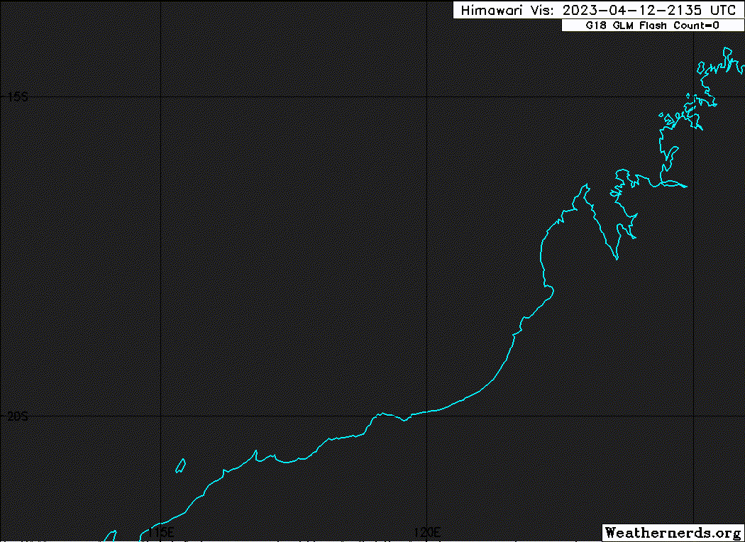
Name: Severe Tropical Cyclone Ilsa
Identifier: 23U
Data At: 0000 UTC
Latitude: 17.7S
Longitude: 118.9E
Location Accuracy: within 10nm (20 km)
Movement Towards: south southwest (201 deg)
Speed of Movement: 8 knots (15 km/h)
Maximum 10-Minute Wind: 90 knots (165 km/h)
Maximum 3-Second Wind Gust: 125 knots (230 km/h)
Central Pressure: 942 hPa
Radius of 34-knot winds NE quadrant: 80 nm (150 km)
Radius of 34-knot winds SE quadrant: 70 nm (130 km)
Radius of 34-knot winds SW quadrant: 60 nm (110 km)
Radius of 34-knot winds NW quadrant: 80 nm (150 km)
Radius of 48-knot winds NE quadrant: 45 nm (85 km)
Radius of 48-knot winds SE quadrant: 30 nm (55 km)
Radius of 48-knot winds SW quadrant: 30 nm (55 km)
Radius of 48-knot winds NW quadrant: 45 nm (85 km)
Radius of 64-knot winds: 30 nm (30 km)
Radius of Maximum Winds: 10 nm (20 km)
Dvorak Intensity Code: T5.5/5.5/D1.5/24HRS STT:D0.5/06HRS
Pressure of outermost isobar: 1004 hPa
Radius of outermost closed isobar: 160 nm (295 km)
FORECAST DATA
Date/Time : Location : Loc. Accuracy: Max Wind : Central Pressure
(UTC) : degrees : nm (km): knots(km/h): hPa
+06: 13/0600: 18.5S 118.8E: 030 (050): 095 (175): 939
+12: 13/1200: 19.2S 119.2E: 040 (070): 100 (185): 936
+18: 13/1800: 20.1S 120.0E: 050 (090): 105 (195): 933
+24: 14/0000: 20.9S 121.3E: 060 (105): 075 (140): 953
+36: 14/1200: 22.1S 125.3E: 080 (145): 040 (075): 995
+48: 15/0000: 22.6S 130.4E: 100 (185): 035 (065): 998
+60: 15/1200: 22.1S 136.3E: 100 (180): 030 (055): 1002
+72: 16/0000: : : :
+96: 17/0000: : : :
+120: 18/0000: : : :
REMARKS:
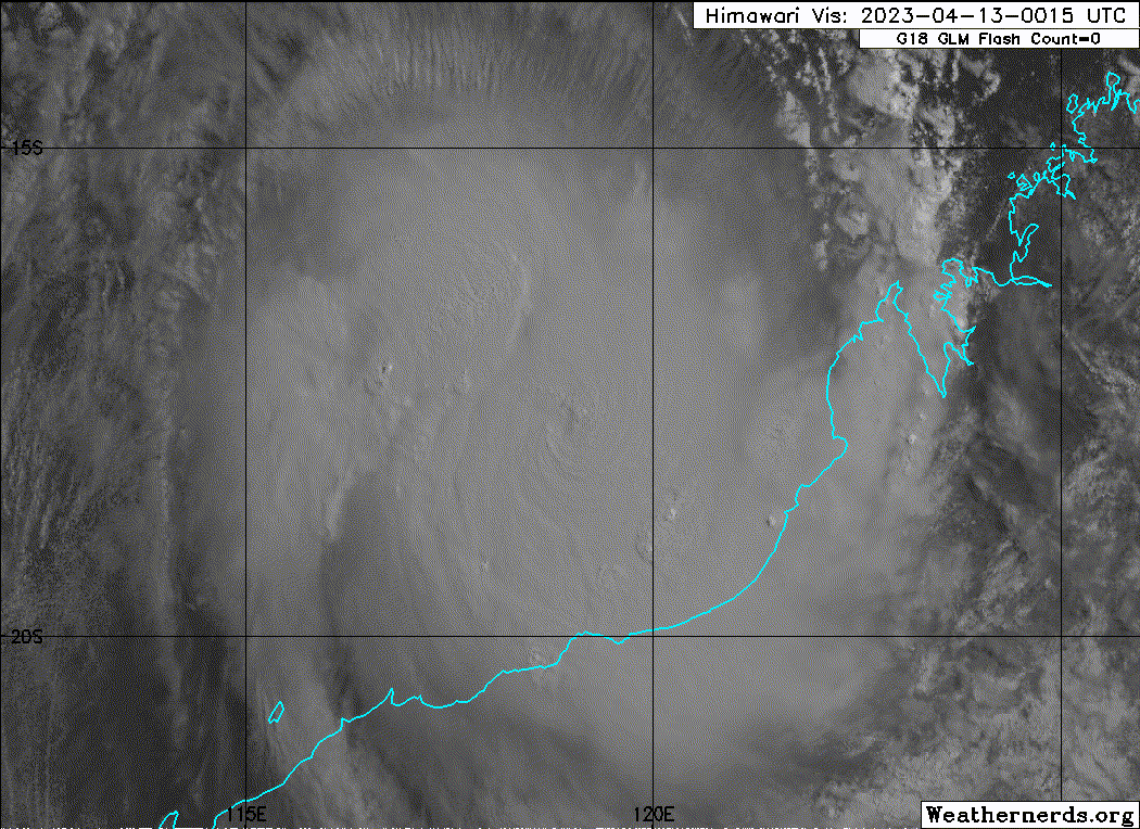
Severe Tropical Cyclone Ilsa as intensified into a category 4 system, and
continues to intensify off the west Kimberley coast.
There is good confidence in the position of the system with an eye visible.
Dvorak analysis of 3 hourly average DT of 5.5 based on an eye pattern. 00Z eye
pattern was CMG surrounding temperature with a B/CMG eye adjustment. MET
yielded 5.0 base on a D 24 hour trend with PAT 5.5. FT/CI=5.5 based on DT.
Objective guidance, with ADT CI of 5.0 CIMSS and 4.9 NESDIS, SATCON at 99 knots
(2000 UTC), AiDT 92 knots, and Open-AIIR ranging between 90 to 100 knots
(1-min). Rowley Shoals AWS recorded a 10 minute mean wind of 82 knots at 2227
UTC and a gust to 127 knots at 2300 UTC just prior to sustaining damage.
Intensity set to 90 knots (category 4) based on Dvorak, objective guidance and
the observed gust at Rowley Shoals.
Wind shear remains moderately low over 23U and at 0000 UTC CIMSS upper wind
analysis has analysed approximately 15 to 20 knots of shear. The system has
been under gong rapid development within the last 24 hors with favourable
shear, high mid-level moisture and warm SSTs (30+ degrees Celsius). The current
forecast intensity is based on a standard development, with the system reaching
a category 4 intensity of 105 knots at landfall. This is consistent with a
consensus of NWP models. 23U is forecast to remain a strong system as it moves
inland on Friday. With the favourable environment and CIMSS AI-RI and other
guidance suggesting a high probability of continued rapid increase in intensity
over the next 12 to 24 hours, the system reaching category 5 intensity before
landfall cannot be ruled out.
Generally there is still relatively high confidence in this forecast track.
Ilsa is forecast to turn to the south and then southeast today. A a coastal
crossing is likely later tonight or early Friday morning east of Port Hedland
and west of Bidyadanga, most likely between Pardoo Roadhouse and Wallal Downs.
In the long-term, Ilsa is forecast to move over central Australia and begin a
transition to a deep, sub-tropical system as it interacts with the sub-tropical
jet.
Issued by AUSTRALIAN BUREAU OF METEOROLOGY TROPICAL CYCLONE WARNING CENTRE
at: 0118 UTC 13/04/2023
Name: Severe Tropical Cyclone Ilsa
Identifier: 23U
Data At: 0000 UTC
Latitude: 17.7S
Longitude: 118.9E
Location Accuracy: within 10nm (20 km)
Movement Towards: south southwest (201 deg)
Speed of Movement: 8 knots (15 km/h)
Maximum 10-Minute Wind: 90 knots (165 km/h)
Maximum 3-Second Wind Gust: 125 knots (230 km/h)
Central Pressure: 942 hPa
Radius of 34-knot winds NE quadrant: 80 nm (150 km)
Radius of 34-knot winds SE quadrant: 70 nm (130 km)
Radius of 34-knot winds SW quadrant: 60 nm (110 km)
Radius of 34-knot winds NW quadrant: 80 nm (150 km)
Radius of 48-knot winds NE quadrant: 45 nm (85 km)
Radius of 48-knot winds SE quadrant: 30 nm (55 km)
Radius of 48-knot winds SW quadrant: 30 nm (55 km)
Radius of 48-knot winds NW quadrant: 45 nm (85 km)
Radius of 64-knot winds: 30 nm (30 km)
Radius of Maximum Winds: 10 nm (20 km)
Dvorak Intensity Code: T5.5/5.5/D1.5/24HRS STT:D0.5/06HRS
Pressure of outermost isobar: 1004 hPa
Radius of outermost closed isobar: 160 nm (295 km)
FORECAST DATA
Date/Time : Location : Loc. Accuracy: Max Wind : Central Pressure
(UTC) : degrees : nm (km): knots(km/h): hPa
+06: 13/0600: 18.5S 118.8E: 030 (050): 095 (175): 939
+12: 13/1200: 19.2S 119.2E: 040 (070): 100 (185): 936
+18: 13/1800: 20.1S 120.0E: 050 (090): 105 (195): 933
+24: 14/0000: 20.9S 121.3E: 060 (105): 075 (140): 953
+36: 14/1200: 22.1S 125.3E: 080 (145): 040 (075): 995
+48: 15/0000: 22.6S 130.4E: 100 (185): 035 (065): 998
+60: 15/1200: 22.1S 136.3E: 100 (180): 030 (055): 1002
+72: 16/0000: : : :
+96: 17/0000: : : :
+120: 18/0000: : : :
REMARKS:
Severe Tropical Cyclone Ilsa as intensified into a category 4 system, and
continues to intensify off the west Kimberley coast.
There is good confidence in the position of the system with an eye visible.
Dvorak analysis of 3 hourly average DT of 5.5 based on an eye pattern. 00Z eye
pattern was CMG surrounding temperature with a B/CMG eye adjustment. MET
yielded 5.0 base on a D 24 hour trend with PAT 5.5. FT/CI=5.5 based on DT.
Objective guidance, with ADT CI of 5.0 CIMSS and 4.9 NESDIS, SATCON at 99 knots
(2000 UTC), AiDT 92 knots, and Open-AIIR ranging between 90 to 100 knots
(1-min). Rowley Shoals AWS recorded a 10 minute mean wind of 82 knots at 2227
UTC and a gust to 127 knots at 2300 UTC just prior to sustaining damage.
Intensity set to 90 knots (category 4) based on Dvorak, objective guidance and
the observed gust at Rowley Shoals.
Wind shear remains moderately low over 23U and at 0000 UTC CIMSS upper wind
analysis has analysed approximately 15 to 20 knots of shear. The system has
been under gong rapid development within the last 24 hors with favourable
shear, high mid-level moisture and warm SSTs (30+ degrees Celsius). The current
forecast intensity is based on a standard development, with the system reaching
a category 4 intensity of 105 knots at landfall. This is consistent with a
consensus of NWP models. 23U is forecast to remain a strong system as it moves
inland on Friday. With the favourable environment and CIMSS AI-RI and other
guidance suggesting a high probability of continued rapid increase in intensity
over the next 12 to 24 hours, the system reaching category 5 intensity before
landfall cannot be ruled out.
Generally there is still relatively high confidence in this forecast track.
Ilsa is forecast to turn to the south and then southeast today. A a coastal
crossing is likely later tonight or early Friday morning east of Port Hedland
and west of Bidyadanga, most likely between Pardoo Roadhouse and Wallal Downs.
In the long-term, Ilsa is forecast to move over central Australia and begin a
transition to a deep, sub-tropical system as it interacts with the sub-tropical
jet.
0 likes
Visit the Caribbean-Central America Weather Thread where you can find at first post web cams,radars
and observations from Caribbean basin members Click Here
and observations from Caribbean basin members Click Here
-
cycloneye
- Admin
- Posts: 139028
- Age: 67
- Joined: Thu Oct 10, 2002 10:54 am
- Location: San Juan, Puerto Rico
Re: SIO: ILSA - Severe Tropical Cyclone
0 likes
Visit the Caribbean-Central America Weather Thread where you can find at first post web cams,radars
and observations from Caribbean basin members Click Here
and observations from Caribbean basin members Click Here


Re: SIO: ILSA - Severe Tropical Cyclone
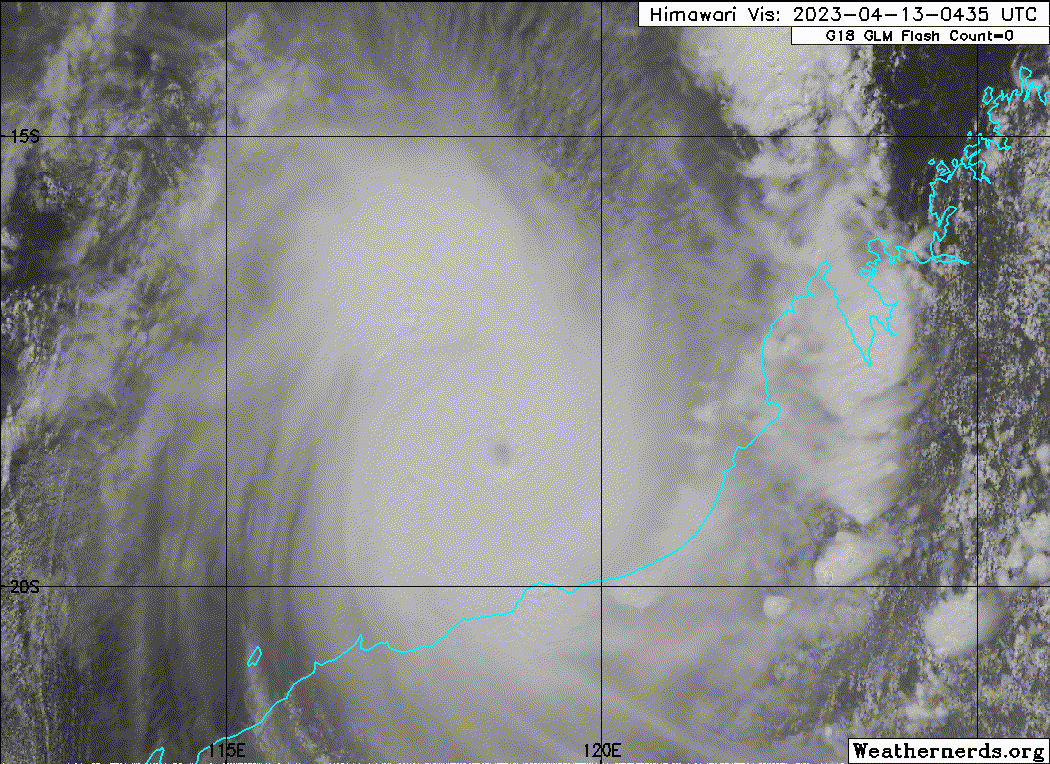
Ilsa is now forecast to become a Category 5 on the Australian scale shortly before landfall. The next weather stations to monitor are Bedout Island (http://www.bom.gov.au/products/IDW60801/IDW60801.94310.shtml) and Pardoo Beef Station (https://weather.agric.wa.gov.au/station/PD).

0 likes
-
cheezyWXguy

- Category 5
- Posts: 5528
- Joined: Mon Feb 13, 2006 12:29 am
- Location: Dallas, TX
Re: SIO: ILSA - Severe Tropical Cyclone
Yeah, given the latest satellite trends I don’t think this is gonna collapse like delta…
0 likes
-
Sciencerocks
- Category 5
- Posts: 7282
- Age: 38
- Joined: Thu Jul 06, 2017 1:51 am
-
Yellow Evan

- Professional-Met

- Posts: 15951
- Age: 25
- Joined: Fri Jul 15, 2011 12:48 pm
- Location: Henderson, Nevada/Honolulu, HI
- Contact:
Re: SIO: ILSA - Severe Tropical Cyclone
Eye become more defined on IR. It will probably shoot up a bit before landfall, maybe to T6.5 range.
1 likes
Re: SIO: ILSA - Severe Tropical Cyclone
The high-resolution observations from Rowley Shoals have just been posted by the Bureau. Note that what is labelled with "wind speed" are actually the observed gusts from this station. Amazing data!
https://twitter.com/BOM_WA/status/1646355612584878081
https://twitter.com/BOM_WA/status/1646355612584878081
1 likes
-
Yellow Evan
- Professional-Met
- Posts: 15951
- Age: 25
- Joined: Fri Jul 15, 2011 12:48 pm
- Location: Henderson, Nevada/Honolulu, HI
- Contact:


-
Yellow Evan
- Professional-Met
- Posts: 15951
- Age: 25
- Joined: Fri Jul 15, 2011 12:48 pm
- Location: Henderson, Nevada/Honolulu, HI
- Contact:
Re: SIO: ILSA - Severe Tropical Cyclone
F. T6.5/6.5/D2.0/24HRS STT: D0.5/03HRS
G. IR/EIR/VIS/MSI
H. REMARKS: 03A/PBO EYE/ANMTN. OW EYE SURROUNDED BY CMG YIELDS AN
E# OF 6.5. ADDED 0.5 EYE ADJUSTMENT FOR CMG, TO YIELD A DT OF 7.0.
MET YIELDS 6.0. PT YIELDS 6.5. DBO PT.
G. IR/EIR/VIS/MSI
H. REMARKS: 03A/PBO EYE/ANMTN. OW EYE SURROUNDED BY CMG YIELDS AN
E# OF 6.5. ADDED 0.5 EYE ADJUSTMENT FOR CMG, TO YIELD A DT OF 7.0.
MET YIELDS 6.0. PT YIELDS 6.5. DBO PT.
Lol JTWC.
0 likes
-
MarioProtVI
- Category 2

- Posts: 669
- Age: 22
- Joined: Sun Sep 29, 2019 7:33 pm
- Location: New Jersey
Re: SIO: ILSA - Severe Tropical Cyclone
JTWC’s first come for Ilsa (with explicit C5 point) seems to be coming back to haunt them.
0 likes

Re: SIO: ILSA - Severe Tropical Cyclone
These are insider met jokes that I simply don't understand! Anyway Ilsa is now rated Cat 5, and if that is sustained it will be the strongest storm to reach shore for quite a while - 16 years maybe.
The whole of usually arid Central Australia might get a very significant rain event.
The whole of usually arid Central Australia might get a very significant rain event.
0 likes
Re: SIO: ILSA - Severe Tropical Cyclone
It's interesting ... this is one of the strongest storms to reach shore this year, but I'm the only person on the forum. Oh well - if it ain't Florida, it ain't happening.
0 likes
-
Sciencerocks
- Category 5
- Posts: 7282
- Age: 38
- Joined: Thu Jul 06, 2017 1:51 am
-
Hurricane2022

- Category 4

- Posts: 911
- Joined: Tue Aug 23, 2022 11:38 pm
- Location: Araçatuba, Brazil
Re: SIO: ILSA - Severe Tropical Cyclone
0 likes
Sorry for the bad English sometimes...!
For reliable and detailed information for any meteorological phenomenon, please consult the National Hurricane Center, Joint Typhoon Warning Center , or your local Meteo Center.
--------
Una cvm Christo, pro Christo, et in Christo. Sit nomen Domini benedictvm.
For reliable and detailed information for any meteorological phenomenon, please consult the National Hurricane Center, Joint Typhoon Warning Center , or your local Meteo Center.
--------
Una cvm Christo, pro Christo, et in Christo. Sit nomen Domini benedictvm.
Re: SIO: ILSA - Severe Tropical Cyclone
To be honest - I have no idea at all why people post links here to Twitter ... it adds absolutely no value at all.
0 likes

Re: SIO: ILSA - Severe Tropical Cyclone
New JTWC Dvorak estimate of T7.0 (Cat 5 on the Saffir-Simpson scale)
TPXS10 PGTW 130851
A. TROPICAL CYCLONE 18S (ILSA)
B. 13/0830Z
C. 19.09S
D. 118.78E
E. ONE/GK2A
F. T7.0/7.0/D2.0/24HRS STT: D0.5/03HRS
G. IR/EIR/VIS/MSI
H. REMARKS: 03A/PBO EYE/ANMTN. WMG EYE SURROUNDED BY W YIELDS AN E#
OF 6.0. ADDED 1.0 EYE ADJUSTMENT FOR CMG, TO YIELD A DT OF 7.0. MET
YIELDS 6.0. PT YIELDS 6.5. DBO DT.
I. ADDITIONAL POSITIONS:
13/0525Z 18.58S 118.73E AMS2
13/0525Z 18.58S 118.73E AMS2
13/0525Z 18.58S 118.73E AMS2
13/0546Z 18.67S 118.75E ATMS
CVACH
0 likes
-
Iceresistance

- Category 5
- Posts: 8911
- Age: 20
- Joined: Sat Oct 10, 2020 9:45 am
- Location: Tecumseh, OK/Norman, OK
Re: SIO: ILSA - Severe Tropical Cyclone
Cargill wrote:To be honest - I have no idea at all why people post links here to Twitter ... it adds absolutely no value at all.
It's there so everyone can see them without the requirement to click the link, let alone device restrictions that won't let you on the site.
0 likes
Bill 2015 & Beta 2020
Winter 2020-2021
All observations are in Tecumseh, OK unless otherwise noted.
Winter posts are focused mainly for Oklahoma & Texas.
Take any of my forecasts with a grain of salt, refer to the NWS, SPC, and NHC for official information
Never say Never with weather! Because ANYTHING is possible!
Winter 2020-2021
All observations are in Tecumseh, OK unless otherwise noted.
Winter posts are focused mainly for Oklahoma & Texas.
Take any of my forecasts with a grain of salt, refer to the NWS, SPC, and NHC for official information
Never say Never with weather! Because ANYTHING is possible!
Re: SIO: ILSA - Severe Tropical Cyclone
Bedout Island is currently recording some incredible data as of 20:10 WST: 111 kt 10-minute sustained, 142 kt gusts, 938.5 hPa.

http://www.bom.gov.au/products/IDW60801/IDW60801.94310.shtml
http://www.bom.gov.au/products/IDW60801/IDW60801.94310.shtml
0 likes
Who is online
Users browsing this forum: No registered users and 14 guests