CPAC: GREG - Remnants - Discussion

Moderator: S2k Moderators

Message
Author
User avatar
cycloneye
Admin
Admin
Posts: 139210
Age: 67
Joined: Thu Oct 10, 2002 10:54 am
Location: San Juan, Puerto Rico

Re: CPAC: GREG - Tropical Storm - Discussion

#41 Postby cycloneye » Mon Aug 14, 2023 9:45 pm

Tropical Storm Greg Discussion Number 5
NWS Central Pacific Hurricane Center Honolulu HI EP082023
500 PM HST Mon Aug 14 2023

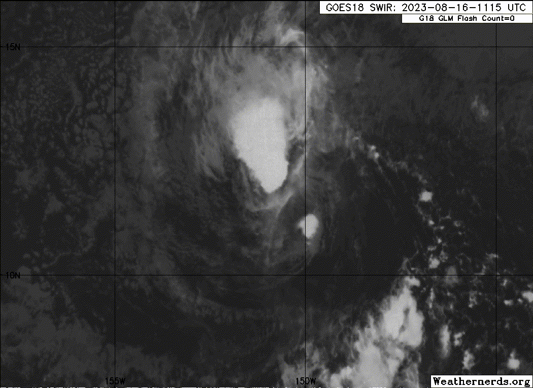
Greg's convection continues to pulse, and remains concentrated on
the west side of the center due to southeasterly shear in the
vicinity. Objective Dvorak intensities range from 34 to 42
kt, and subjective intensities from PHFO, SAB and JTWC are between
2.5 and 3.0. Using a blend of these estimates, maintaining the
initial intensity at 40 kt.

The initial motion is 270/10 kt. Greg continues to move to the west
on the southern edge of the subtropical ridge to the north. Expect
little change in this over the next couple of days, with Greg
heading in a west to slightly west-northwest direction. As the
system reaches the western edge of the ridge, it is expected to
weaken and slowly take a turn to the southwest. On this path, Greg
will pass far south of the Hawaiian Islands Thursday and Friday,
with no direct impacts to the state. The forecast track remains
similar to the previous forecast, with some influence from the HCCA
and TVCE. The track slows the forward progress a bit for hours 36 to
60 based on the HCCA and TVCE, and is a touch further north around
hour 60.

Greg remains over very warm waters, with weakening southeasterly
shear. Over the next 36 hours, the shear is expected to weaken,
which will allow Greg to slowly strengthen. The forecast intensity
is on the high end of the consensus models during this time, and
then follows the gradual weakening trend in the guidance. Between
hours 48 and 60, Greg will move over slightly cooler waters, with an
increase in deep layer shear, and mid-level dry air beginning to
feed into the system. These all contribute to the weakening of the
system between days 2 and 3, with Greg becoming post-tropical on day
4, and opening up into a trough and dissipating by day 5.


FORECAST POSITIONS AND MAX WINDS

INIT 15/0300Z 11.3N 143.1W 40 KT 45 MPH
12H 15/1200Z 11.5N 145.0W 45 KT 50 MPH
24H 16/0000Z 11.7N 147.4W 45 KT 50 MPH
36H 16/1200Z 12.1N 149.9W 45 KT 50 MPH
48H 17/0000Z 12.7N 152.2W 40 KT 45 MPH
60H 17/1200Z 12.8N 154.6W 40 KT 45 MPH
72H 18/0000Z 12.6N 157.3W 35 KT 40 MPH
96H 19/0000Z 11.8N 162.5W 30 KT 35 MPH...POST-TROP/REMNT LOW
120H 20/0000Z...DISSIPATED

$$
Forecaster M Ballard
0 likes   
Visit the Caribbean-Central America Weather Thread where you can find at first post web cams,radars
and observations from Caribbean basin members Click Here

User avatar
cycloneye
Admin
Admin
Posts: 139210
Age: 67
Joined: Thu Oct 10, 2002 10:54 am
Location: San Juan, Puerto Rico

Re: CPAC: GREG - Tropical Storm - Discussion

#42 Postby cycloneye » Tue Aug 15, 2023 4:47 am

Tropical Storm Greg Discussion Number 6
NWS Central Pacific Hurricane Center Honolulu HI EP082023
1100 PM HST Mon Aug 14 2023

Deep convection associated with Greg continues to develop over and
west of the low-level circulation this evening, due to a slight
increase in easterly shear in the past few hours that was estimated
to be around 5 to 10 kt. Recent SSMIS (0359Z) microwave data,
however, showed some evidence of a formative inner core beginning
to evolve. The various 06 UTC objective and subjective satellite
intensity estimates ranged from 35-45 kt. As a result, the initial
intensity is raised to 45 kt.

The initial motion for this advisory is 270/12 kt, as Greg
continues to move south of the subtropical ridge. Greg is forecast
to gradually turn west-northwestward over the next couple of days
while being steered by a mid- to upper-level ridge to the north.
Thereafter, a gradual turn to the west-southwest is forecast as the
weakening system becomes steered by the low- to mid-level flow.
This forecast track is slightly south of the previous track through
day 2, with very little differences thereafter as Greg passes well
south of the Hawaiian Islands. This forecast track closely follows
a combination of the previous forecast, HCCA, and TVCE.

The tropical storm has a brief window to intensify over the next 24
to 36 h as it tracks over warm SSTs (27-28C) and remains in a
relatively moist environment with minimal shear. Therefore, the
forecast depicts some strengthening within the initial 24 h, then
remains steady through 36 h, which is supported by the latest
intensity consensus aids. Beyond that, drier mid-level air along
with an increase in shear and slightly cooler waters should result
in a weakening trend, with Greg becoming post-tropical by day 4.


FORECAST POSITIONS AND MAX WINDS

INIT 15/0900Z 11.2N 144.6W 45 KT 50 MPH
12H 15/1800Z 11.3N 146.3W 50 KT 60 MPH
24H 16/0600Z 11.7N 148.7W 50 KT 60 MPH
36H 16/1800Z 12.2N 151.2W 50 KT 60 MPH
48H 17/0600Z 12.6N 153.6W 45 KT 50 MPH
60H 17/1800Z 12.6N 156.0W 45 KT 50 MPH
72H 18/0600Z 12.3N 158.5W 40 KT 45 MPH
96H 19/0600Z 11.5N 163.7W 30 KT 35 MPH...POST-TROP/REMNT LOW
120H 20/0600Z...DISSIPATED

$$
Forecaster Gibbs/Jelsema
0 likes   
Visit the Caribbean-Central America Weather Thread where you can find at first post web cams,radars
and observations from Caribbean basin members Click Here

User avatar
cycloneye
Admin
Admin
Posts: 139210
Age: 67
Joined: Thu Oct 10, 2002 10:54 am
Location: San Juan, Puerto Rico

Re: CPAC: GREG - Tropical Storm - Discussion

#43 Postby cycloneye » Tue Aug 15, 2023 9:54 am

Tropical Storm Greg Discussion Number 7
NWS Central Pacific Hurricane Center Honolulu HI EP082023
500 AM HST Tue Aug 15 2023

Deep convection has increased over the center of the system during
the past few hours, which is a result of the persistent east-
southeasterly shear over the past 12 to 18 h easing. Recent
microwave data from AMSR2 (1137 UTC) showed evidence of an inner
core that has developed, which has improved from previous microwave
data. Based on the microwave data and the 12 UTC subjective Dvorak
intensity estimates ranging from 35 to 45 kt between PHFO, SAB, AND
JTWC, the initial intensity is held at 45 kt.

The initial motion for this advisory remains at 270/12 kt, as Greg
continues to move south of the subtropical ridge. Greg is forecast
to gradually turn west-northwestward through the day today while
being steered by a mid- to upper-level ridge to the north, which
will persist through late Wednesday. Thereafter, a gradual turn to
the west-southwest is forecast as the weakening system becomes
steered by the low- to mid-level flow. This forecast track is very
similar to the previous forecast, and shows Greg passing well south
of the Hawaiian Islands Wednesday night through Thursday night.
This forecast track closely follows a combination of the previous
forecast, HCCA, and TVCE.

The tropical storm has a brief window to intensify over the next 36
h as it tracks over warm SSTs (27-28C) and remains in a relatively
moist environment with minimal shear. Therefore, the forecast
depicts some strengthening within the initial 36 h, which is
supported by the latest intensity consensus aids. Beyond that,
drier mid-level air along with the potential for a slight increase
in shear and cooler waters should result in a weakening trend, with
Greg becoming post-tropical on day 4.


FORECAST POSITIONS AND MAX WINDS

INIT 15/1500Z 11.1N 145.9W 45 KT 50 MPH
12H 16/0000Z 11.4N 147.6W 50 KT 60 MPH
24H 16/1200Z 11.9N 150.1W 50 KT 60 MPH
36H 17/0000Z 12.4N 152.6W 55 KT 65 MPH
48H 17/1200Z 12.6N 155.0W 50 KT 60 MPH
60H 18/0000Z 12.4N 157.5W 45 KT 50 MPH
72H 18/1200Z 12.1N 160.2W 40 KT 45 MPH
96H 19/1200Z 11.3N 165.3W 30 KT 35 MPH...POST-TROP/REMNT LOW
120H 20/1200Z...DISSIPATED

$$
Forecaster Gibbs/Jelsema
0 likes   
Visit the Caribbean-Central America Weather Thread where you can find at first post web cams,radars
and observations from Caribbean basin members Click Here

Sciencerocks
Category 5
Category 5
Posts: 7287
Age: 38
Joined: Thu Jul 06, 2017 1:51 am

Re: CPAC: GREG - Tropical Storm - Discussion

#44 Postby Sciencerocks » Tue Aug 15, 2023 1:13 pm

Image
1 likes   

Sciencerocks
Category 5
Category 5
Posts: 7287
Age: 38
Joined: Thu Jul 06, 2017 1:51 am

Re: CPAC: GREG - Tropical Storm - Discussion

#45 Postby Sciencerocks » Tue Aug 15, 2023 3:21 pm

Image
1 likes   

User avatar
cycloneye
Admin
Admin
Posts: 139210
Age: 67
Joined: Thu Oct 10, 2002 10:54 am
Location: San Juan, Puerto Rico

Re: CPAC: GREG - Tropical Storm - Discussion

#46 Postby cycloneye » Tue Aug 15, 2023 3:51 pm


Tropical Storm Greg Discussion Number 8
NWS Central Pacific Hurricane Center Honolulu HI EP082023
1100 AM HST Tue Aug 15 2023

The satellite presentation of Greg has not changed significantly
this morning, as relatively light, easterly vertical wind shear
continues to restrict outflow within the eastern semicircle. Deep
convection has been persistent to the southwest of the low-level
circulation center, while banding has developed to the north. HFO
and JTWC reported a Dvorak current intensity of 3.0/45 kt, and
CIMSS ADT came in at 41 kt. Given no substantial change in the
satellite presentation, the current intensity will be held at 45 kt
for this advisory.

The initial motion for this advisory is 275/12 kt. Greg is moving
toward the west along the southern edge of a deep subtropical
ridge. A turn toward the west-northwest is forecast later today and
Wednesday as Greg advances toward a weakness in the ridge aloft. A
turn toward the west is expected Thursday as the ridge aloft begins
to strengthen, causing Greg to pass several hundred miles south of
Hawaii. A turn toward the west-southwest is expected on Friday as
the weakening tropical cyclone is steered by the deep ridge to the
north. The forecast track was altered little from the prior
advisory and lies near TVCE in the middle of a relatively clustered
guidance envelope.

The greatest chance for strengthening lies within the next 24 hours
or so, when vertical wind shear is expected to relax slightly and
the SST remains around 28C. The statistical guidance has been
tending to forecast intensification during this time and has been
holding Greg at a higher intensity through the following several
days. Meanwhile, the dynamical guidance is showing little to no
intensification in the next 24 hours, followed by steady weakening,
possibly due to drier air aloft disrupting the tropical cyclone and
slightly cooler SST. The intensity forecast allows for
intensification through Wednesday, followed by weakening from
Thursday onward, with Greg becoming post-tropical on Saturday. This
forecast follows the general trend of HCCA, though the official
forecast is held slightly higher than this guidance through the
next four days.


FORECAST POSITIONS AND MAX WINDS

INIT 15/2100Z 11.2N 147.2W 45 KT 50 MPH
12H 16/0600Z 11.6N 149.0W 50 KT 60 MPH
24H 16/1800Z 12.1N 151.5W 50 KT 60 MPH
36H 17/0600Z 12.5N 153.9W 50 KT 60 MPH
48H 17/1800Z 12.6N 156.4W 45 KT 50 MPH
60H 18/0600Z 12.3N 159.0W 40 KT 45 MPH
72H 18/1800Z 11.9N 161.7W 35 KT 40 MPH
96H 19/1800Z 11.0N 166.6W 30 KT 35 MPH...POST-TROP/REMNT LOW
120H 20/1800Z...DISSIPATED

$$
Forecaster Wroe
0 likes   
Visit the Caribbean-Central America Weather Thread where you can find at first post web cams,radars
and observations from Caribbean basin members Click Here

User avatar
cycloneye
Admin
Admin
Posts: 139210
Age: 67
Joined: Thu Oct 10, 2002 10:54 am
Location: San Juan, Puerto Rico

Re: CPAC: GREG - Tropical Storm - Discussion

#47 Postby cycloneye » Tue Aug 15, 2023 9:44 pm

BULLETIN
Tropical Storm Greg Advisory Number 9
NWS Central Pacific Hurricane Center Honolulu HI EP082023
500 PM HST Tue Aug 15 2023

...TROPICAL STORM GREG CONTINUES MOVING WESTWARD...


SUMMARY OF 500 PM HST...0300 UTC...INFORMATION
----------------------------------------------
LOCATION...11.5N 148.3W
ABOUT 930 MI...1495 KM SE OF HONOLULU HAWAII
ABOUT 725 MI...1165 KM SE OF HILO HAWAII
MAXIMUM SUSTAINED WINDS...50 MPH...85 KM/H
PRESENT MOVEMENT...W OR 280 DEGREES AT 14 MPH...22 KM/H
MINIMUM CENTRAL PRESSURE...1000 MB...29.53 INCHES


Tropical Storm Greg Discussion Number 9
NWS Central Pacific Hurricane Center Honolulu HI EP082023
500 PM HST Tue Aug 15 2023

Deep convection around Tropical Storm Greg has been pulsing through
the day, and a partially exposed low-level circulation center can
be discerned through a thin veil of mid-level clouds on visible
imagery this afternoon. Though light, southeasterly vertical wind
shear is affecting the tropical storm, and fix agencies came in
with a wide range of intensity estimates, from 2.5 out of SAB, to
3.0 at HFO, and 3.5 from JTWC. The current intensity from CIMSS ADT
was recently 47 kt, though that estimate was elevated due to deep
convection that had flared late this morning. Given the lack of
substantial improvement in the satellite presentation and pulsing
nature of the deep convection, a blend of these inputs supports
holding the intensity at 45 kt for this advisory.

The initial motion for this advisory is 280/12 kt. Greg appears to
be starting the anticipated turn to the west-northwest toward a
weakness aloft in the deep ridge north of the tropical cyclone. A
general forward motion toward the west-northwest is expected
tonight and much of Wednesday. Confidence is high that Greg will
turn toward the west Wednesday night and Thursday as the ridge aloft
begins to strengthen, causing Greg to pass several hundred miles
south of Hawaii. A turn toward the west-southwest is forecast
Thursday night and Friday as the weakening tropical cyclone is
steered by the deep ridge to the north. The official forecast track
is essentially an update of the prior advisory and lies near TVCE
in the middle of a relatively clustered guidance envelope.

The greatest chance for any additional strengthening will be in the
short term, when vertical wind shear will remain light and the SST
will hold around 28C. The guidance continues to be split into two
camps. The statistical models are showing slight intensification
over the next day or so followed by little change for several days.
Conversely, the dynamical models show little to no short term
intensification, followed by steady weakening through the next
four days, possibly due to drier air aloft disrupting Greg and
slightly cooler SST along the forecast track. The updated intensity
forecast allows for some short term strengthening into Wednesday,
followed by steady weakening as depicted by the bulk of the
dynamical guidance, with Greg becoming post-tropical on Saturday.


FORECAST POSITIONS AND MAX WINDS

INIT 16/0300Z 11.5N 148.3W 45 KT 50 MPH
12H 16/1200Z 11.8N 150.2W 50 KT 60 MPH
24H 17/0000Z 12.2N 152.6W 50 KT 60 MPH
36H 17/1200Z 12.5N 155.1W 45 KT 50 MPH
48H 18/0000Z 12.3N 157.6W 40 KT 45 MPH
60H 18/1200Z 12.0N 160.2W 35 KT 40 MPH
72H 19/0000Z 11.7N 162.9W 30 KT 35 MPH
96H 20/0000Z 10.8N 168.0W 25 KT 30 MPH...POST-TROP/REMNT LOW
120H 21/0000Z...DISSIPATED

$$
Forecaster Wroe
0 likes   
Visit the Caribbean-Central America Weather Thread where you can find at first post web cams,radars
and observations from Caribbean basin members Click Here

Sciencerocks
Category 5
Category 5
Posts: 7287
Age: 38
Joined: Thu Jul 06, 2017 1:51 am

Re: CPAC: GREG - Tropical Storm - Discussion

#48 Postby Sciencerocks » Tue Aug 15, 2023 10:49 pm

Image
0 likes   

User avatar
cycloneye
Admin
Admin
Posts: 139210
Age: 67
Joined: Thu Oct 10, 2002 10:54 am
Location: San Juan, Puerto Rico

Re: CPAC: GREG - Tropical Storm - Discussion

#49 Postby cycloneye » Wed Aug 16, 2023 9:43 am

TCDCP3

Tropical Storm Greg Discussion Number 11
NWS Central Pacific Hurricane Center Honolulu HI EP082023
500 AM HST Wed Aug 16 2023

Over the last several hours, the southeastern edge of the low
level center has been apparent at times on the CIRA ProxyVis
imagery. Convection has been pulsing as it is sheared to the
northwest of the center. An 0430Z HY-2B scatterometer pass showed 40
kt on the north side of the center. Subjective Dvorak intensities
from PHFO, JTWC and SAB range from 2.5 to 3.5, while objective
intensities range from 31 to 41 kt. Using a blend of these
estimates, will hold the initial intensity at 45 kt.

The initial motion is 280/12 kt, continuing a slightly north of west
path. Greg continues to move along the southern edge of a
subtropical ridge to the north. As it continues to the west today,
it will gain some latitude as it reaches the western end of the
ridge. A building deep layer ridge to the north will then help to
steer Greg to the west-southwest Thursday night and Friday. There
is little change in the forecast track, continuing to closely
follow the HCCA and TVCA which remain near the middle of a
relatively tightly clustered guidance envelope. Along this track,
Greg will pass far south of Hawaii Thursday through Friday with no
direct impacts to the islands.

With the convection at times being displaced to the north of the
center, Greg appears at times to be encountering some additional
southerly shear, but remains over sufficiently warm waters. Little
change is expected in the next 24 to 36 hours, however anticipate
additional bursts of shear, which will hinder strengthening. Beyond
36 hours, the system will move over slightly cooler waters, and
begin to encounter stronger shear from the west. The intensity
forecast has been held at 45 kt through 24 hours, which is on the
high end of the consensus models. Beyond that, the gradual
weakening in the forecast follows the IVCN trend.


FORECAST POSITIONS AND MAX WINDS

INIT 16/1500Z 11.8N 151.1W 45 KT 50 MPH
12H 17/0000Z 12.1N 153.0W 45 KT 50 MPH
24H 17/1200Z 12.2N 155.3W 45 KT 50 MPH
36H 18/0000Z 12.1N 157.8W 40 KT 45 MPH
48H 18/1200Z 11.8N 160.5W 35 KT 40 MPH
60H 19/0000Z 11.4N 163.2W 35 KT 40 MPH
72H 19/1200Z 11.1N 165.8W 30 KT 35 MPH
96H 20/1200Z 10.1N 170.8W 25 KT 30 MPH...POST-TROP/REMNT LOW
120H 21/1200Z...DISSIPATED

$$
Forecaster M Ballard
0 likes   
Visit the Caribbean-Central America Weather Thread where you can find at first post web cams,radars
and observations from Caribbean basin members Click Here

Sciencerocks
Category 5
Category 5
Posts: 7287
Age: 38
Joined: Thu Jul 06, 2017 1:51 am

Re: CPAC: GREG - Tropical Storm - Discussion

#50 Postby Sciencerocks » Wed Aug 16, 2023 9:43 am

Image
1 likes   

User avatar
cycloneye
Admin
Admin
Posts: 139210
Age: 67
Joined: Thu Oct 10, 2002 10:54 am
Location: San Juan, Puerto Rico

Re: CPAC: GREG - Tropical Storm - Discussion

#51 Postby cycloneye » Wed Aug 16, 2023 3:50 pm

Tropical Storm Greg Discussion Number 12
NWS Central Pacific Hurricane Center Honolulu HI EP082023
1100 AM HST Wed Aug 16 2023

Greg continues to be affected by southeasterly vertical wind shear,
and pulsing deep convection remains largely displaced to the north
and west of a partially exposed low-level circulation center. JTWC
and SAB came in with a current intensity of 2.5/35 kt, and HFO
estimated 3.5/55 kt, while CIMSS ADT was down at 37 kt. Given that
the satellite presentation is slightly degraded, a blend of these
inputs supports dropping the official intensity to 40 kt with this
advisory.

Greg remains on a relatively steady forward motion that is slightly
north of due west, 280/12 kt. A low- to mid-level ridge far to the
north will keep the tropical cyclone moving along a general
westward track through the next 36 hours, causing Greg to pass well
south of Hawaii. A turn toward the west-southwest is forecast on
Friday as the weakening tropical cyclone is steered by a deepening
ridge to the north. The official forecast track was changed little
from the prior advisory and lies near TVCE in the middle of a
tightly clustered guidance envelope.

The intensity forecast is more challenging. Relatively light,
southerly vertical wind shear has been rather disruptive, leading
to the pulsing deep convection near the center of Greg. Conditions
will change little during the next 24 hours or so, and the official
forecast indicates no change in intensity, which is higher than all
guidance. Beyond 24 hours, guidance continues to split into two
camps. The dynamical guidance shows steady weakening as a deep,
strengthening ridge to the north imparts westerly to northwesterly
vertical wind shear, while the statistical guidance continues to
suggest some intensification. Given the tropical cyclone's
inability to resist the current shear environment, the official
forecast follows the steady weakening trend at the higher end of
the dynamical guidance envelope beyond 24 hours, and Greg is
expected to become a post-tropical remnant low this weekend.


FORECAST POSITIONS AND MAX WINDS

INIT 16/2100Z 11.9N 152.5W 40 KT 45 MPH
12H 17/0600Z 12.1N 154.3W 40 KT 45 MPH
24H 17/1800Z 12.2N 156.6W 40 KT 45 MPH
36H 18/0600Z 12.1N 159.1W 35 KT 40 MPH
48H 18/1800Z 11.8N 161.7W 35 KT 40 MPH
60H 19/0600Z 11.3N 164.4W 30 KT 35 MPH
72H 19/1800Z 11.0N 167.0W 30 KT 35 MPH...POST-TROP/REMNT LOW
96H 20/1800Z 10.1N 171.7W 25 KT 30 MPH...POST-TROP/REMNT LOW
120H 21/1800Z...DISSIPATED

$$
Forecaster Wroe
0 likes   
Visit the Caribbean-Central America Weather Thread where you can find at first post web cams,radars
and observations from Caribbean basin members Click Here

Sciencerocks
Category 5
Category 5
Posts: 7287
Age: 38
Joined: Thu Jul 06, 2017 1:51 am

Re: CPAC: GREG - Tropical Storm - Discussion

#52 Postby Sciencerocks » Wed Aug 16, 2023 4:01 pm

Image
1 likes   

Sciencerocks
Category 5
Category 5
Posts: 7287
Age: 38
Joined: Thu Jul 06, 2017 1:51 am

Re: CPAC: GREG - Tropical Storm - Discussion

#53 Postby Sciencerocks » Wed Aug 16, 2023 10:03 pm

Image
0 likes   

User avatar
cycloneye
Admin
Admin
Posts: 139210
Age: 67
Joined: Thu Oct 10, 2002 10:54 am
Location: San Juan, Puerto Rico

Re: CPAC: GREG - Tropical Storm - Discussion

#54 Postby cycloneye » Wed Aug 16, 2023 10:15 pm

Tropical Storm Greg Discussion Number 13
NWS Central Pacific Hurricane Center Honolulu HI EP082023
500 PM HST Wed Aug 16 2023

Deep convection surrounding Greg continues to pulse under the
influence of southeasterly vertical wind shear. This has displaced
much of the convection to the north of a partially exposed
low-level circulation center. Dvorak current intensity estimates
range from 2.0/30 kt by SAB, to 3.5/35 kt out of JTWC, to 3.0/45 kt
at HFO. Since a 2343 UTC CIMSS SATCON came in at 43 kt and CIMSS ADT
was recently holding as high as 37 kt, a blend of the inputs
supports keeping the official intensity at 40 kt for this advisory,
though that may be generous.

Greg remains on a relatively steady forward motion that is slightly
north of due west, 280/11 kt. A low- to mid-level ridge far to the
north will keep the tropical cyclone moving along a general
westward track through Thursday night, causing Greg to pass well
south of Hawaii. A turn toward the west-southwest is forecast on
Friday as the weakening tropical cyclone is steered by a deepening
ridge to the north. The official forecast track was altered little
from the prior advisory and lies near TVCE in the middle of a
tightly clustered guidance envelope.

Relatively light, southerly vertical wind shear will likely produce
only slow weakening of Greg over the next day or so. Beyond 24
hours, the dynamical guidance suggests steady weakening, likely due
to a gradual increase in northerly vertical wind shear produced by
a strengthening ridge aloft to the north. Conversely, the
statistical guidance shows little short term change in Greg,
followed by some strengthening. Given the tropical cyclone's
inability to strengthen within the current shear environment and
sufficiently warm SST, the official forecast follows the steady
weakening trend of the dynamical guidance beyond 24 hours, and Greg
is expected to become a post-tropical remnant low by late Friday or
Saturday.


FORECAST POSITIONS AND MAX WINDS

INIT 17/0300Z 12.1N 153.5W 40 KT 45 MPH
12H 17/1200Z 12.2N 155.2W 40 KT 45 MPH
24H 18/0000Z 12.3N 157.6W 35 KT 40 MPH
36H 18/1200Z 12.1N 160.3W 35 KT 40 MPH
48H 19/0000Z 11.7N 163.0W 30 KT 35 MPH
60H 19/1200Z 11.3N 165.5W 30 KT 35 MPH...POST-TROP/REMNT LOW
72H 20/0000Z 10.8N 168.0W 25 KT 30 MPH...POST-TROP/REMNT LOW
96H 21/0000Z...DISSIPATED

$$
Forecaster Wroe
0 likes   
Visit the Caribbean-Central America Weather Thread where you can find at first post web cams,radars
and observations from Caribbean basin members Click Here

User avatar
cycloneye
Admin
Admin
Posts: 139210
Age: 67
Joined: Thu Oct 10, 2002 10:54 am
Location: San Juan, Puerto Rico

Re: CPAC: GREG - Tropical Storm - Discussion

#55 Postby cycloneye » Thu Aug 17, 2023 9:50 am

Tropical Storm Greg Discussion Number 15
NWS Central Pacific Hurricane Center Honolulu HI EP082023
500 AM HST Thu Aug 17 2023

Greg has quickly become disorganized overnight, with convection
becoming further displaced to the north, and then rapidly weakening.
As the convection became displaced, the exposed low level center
began moving south of due west. The subjective and objective
estimates range from 25 to 45 kt. A blend of these lead to
lowering the initial intensity to 35 kt, but that may be too
generous. It is possible that Greg could be declared post-tropical
later today.

The initial motion is 270/11 kt. As the convection weakened, the
exposed low level center took a short jog to the west-southwest,
but is now back on its expected westward path. This westward motion
is expected to continue today as Greg follows the southern edge of
a ridge to the north. This path will have Greg passing well south
of Hawaii today, before turning to the west-southwest as it
weakens. The forecast track closely follows the previous package
leaning towards the TVCA which remains in the middle of the
relatively tightly clustered guidance.

The intensity forecast is a bit more challenging. Limited convection
has become significantly sheared to the north of the low level
center. Statistical guidance shows Greg remaining in a low sheared
environment for the next 24 hours. However the satellite depiction
would suggest that Greg was under the influence of stronger shear
overnight. While it is possible for convection to redevelop near
the center should shear remain low, there is good agreement in the
guidance that shear will increase from the west to northwest
beyond 24 hours. This leaves a limited window for any development
of the system. Have held the intensity at 35 kt for the first 12
hours, and then followed the gradual weakening trend of the
dynamical guidance.


FORECAST POSITIONS AND MAX WINDS

INIT 17/1500Z 11.9N 155.6W 35 KT 40 MPH
12H 18/0000Z 12.0N 157.4W 35 KT 40 MPH
24H 18/1200Z 11.9N 159.9W 30 KT 35 MPH
36H 19/0000Z 11.5N 162.5W 30 KT 35 MPH
48H 19/1200Z 11.1N 165.1W 30 KT 35 MPH...POST-TROP/REMNT LOW
60H 20/0000Z 10.6N 167.6W 25 KT 30 MPH...POST-TROP/REMNT LOW
72H 20/1200Z...DISSIPATED

$$
Forecaster M Ballard
0 likes   
Visit the Caribbean-Central America Weather Thread where you can find at first post web cams,radars
and observations from Caribbean basin members Click Here

User avatar
cycloneye
Admin
Admin
Posts: 139210
Age: 67
Joined: Thu Oct 10, 2002 10:54 am
Location: San Juan, Puerto Rico

Re: CPAC: GREG - Tropical Depression - Discussion

#56 Postby cycloneye » Thu Aug 17, 2023 3:40 pm

BULLETIN
Tropical Depression Greg Advisory Number 16
NWS Central Pacific Hurricane Center Honolulu HI EP082023
1100 AM HST Thu Aug 17 2023

...WEAKENING GREG WILL LIKELY SOON BECOME POST-TROPICAL...


SUMMARY OF 1100 AM HST...2100 UTC...INFORMATION
-----------------------------------------------
LOCATION...12.2N 157.1W
ABOUT 630 MI...1015 KM S OF HONOLULU HAWAII
ABOUT 480 MI...770 KM S OF SOUTH POINT HAWAII
MAXIMUM SUSTAINED WINDS...35 MPH...55 KM/H
PRESENT MOVEMENT...W OR 270 DEGREES AT 13 MPH...20 KM/H
MINIMUM CENTRAL PRESSURE...1007 MB...29.74 INCHES


WATCHES AND WARNINGS
--------------------
There are no coastal watches or warnings in effect.


DISCUSSION AND OUTLOOK
----------------------
At 1100 AM HST (2100 UTC), the center of Tropical Depression Greg
was located near latitude 12.2 North, longitude 157.1 West. The
depression is moving toward the west near 13 mph (20 km/h), and this
motion is expected to continue for the next day or two.

Maximum sustained winds are near 35 mph (55 km/h) with higher gusts.
Greg will continue to gradually weaken over the next day or so,
then dissipate by Saturday.

The estimated minimum central pressure is 1007 mb (29.74 inches).


HAZARDS AFFECTING LAND
----------------------
None


NEXT ADVISORY
-------------
Next complete advisory at 500 PM HST.

$$
Forecaster Birchard
0 likes   
Visit the Caribbean-Central America Weather Thread where you can find at first post web cams,radars
and observations from Caribbean basin members Click Here

Sciencerocks
Category 5
Category 5
Posts: 7287
Age: 38
Joined: Thu Jul 06, 2017 1:51 am

Re: CPAC: GREG - Tropical Depression - Discussion

#57 Postby Sciencerocks » Thu Aug 17, 2023 4:17 pm

Image
0 likes   

User avatar
cycloneye
Admin
Admin
Posts: 139210
Age: 67
Joined: Thu Oct 10, 2002 10:54 am
Location: San Juan, Puerto Rico

Re: CPAC: GREG - Remnants - Discussion

#58 Postby cycloneye » Thu Aug 17, 2023 9:38 pm

Bye.

BULLETIN
Post-Tropical Cyclone Greg Advisory Number 17
NWS Central Pacific Hurricane Center Honolulu HI EP082023
500 PM HST Thu Aug 17 2023

...GREG BECOMES A POST-TROPICAL REMNANT LOW FAR SOUTH OF HAWAII...
...THIS WILL BE THE LAST ADVISORY...


SUMMARY OF 500 PM HST...0300 UTC...INFORMATION
----------------------------------------------
LOCATION...12.0N 158.5W
ABOUT 645 MI...1035 KM S OF HONOLULU HAWAII
ABOUT 520 MI...835 KM SSW OF SOUTH POINT HAWAII
MAXIMUM SUSTAINED WINDS...35 MPH...55 KM/H
PRESENT MOVEMENT...W OR 265 DEGREES AT 17 MPH...28 KM/H
MINIMUM CENTRAL PRESSURE...1007 MB...29.74 INCHES
0 likes   
Visit the Caribbean-Central America Weather Thread where you can find at first post web cams,radars
and observations from Caribbean basin members Click Here


Return to “2023”

Who is online

Users browsing this forum: No registered users and 55 guests