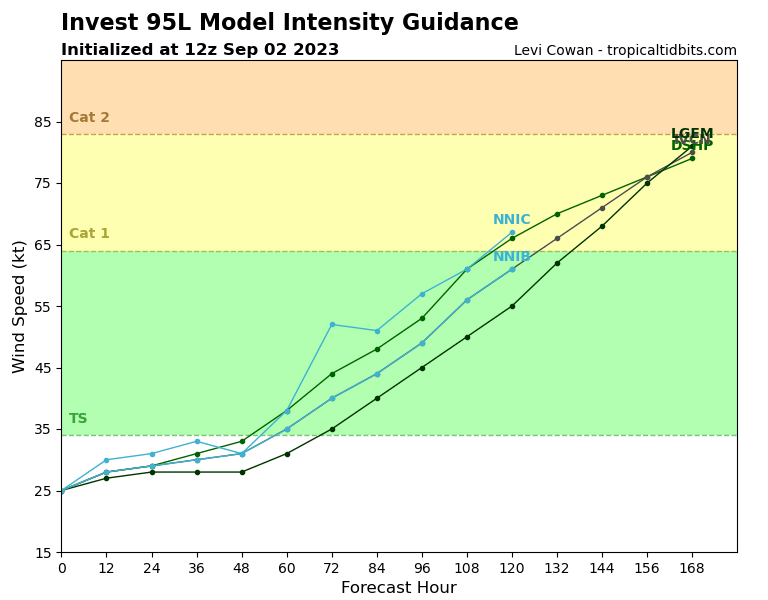
ATL: LEE - Models
Moderator: S2k Moderators
- WalterWhite
- Category 1

- Posts: 311
- Joined: Fri Mar 17, 2023 5:53 pm
ATL: LEE - Models

Last edited by WalterWhite on Tue Sep 05, 2023 3:25 pm, edited 1 time in total.
0 likes
- SFLcane
- S2K Supporter

- Posts: 9606
- Age: 46
- Joined: Sat Jun 05, 2010 1:44 pm
- Location: Lake Worth Florida
Re: ATL: INVEST 95L - Discussion
Being in Florida personally I don’t feel comfortable being this close so far out so i am watching this one.
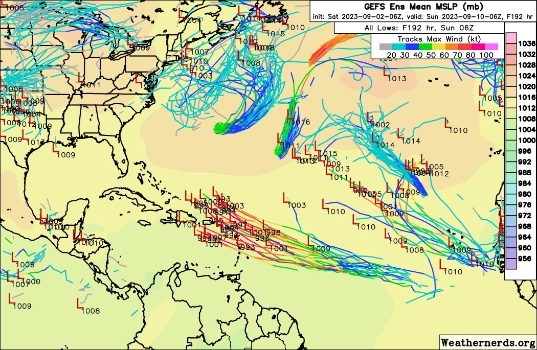
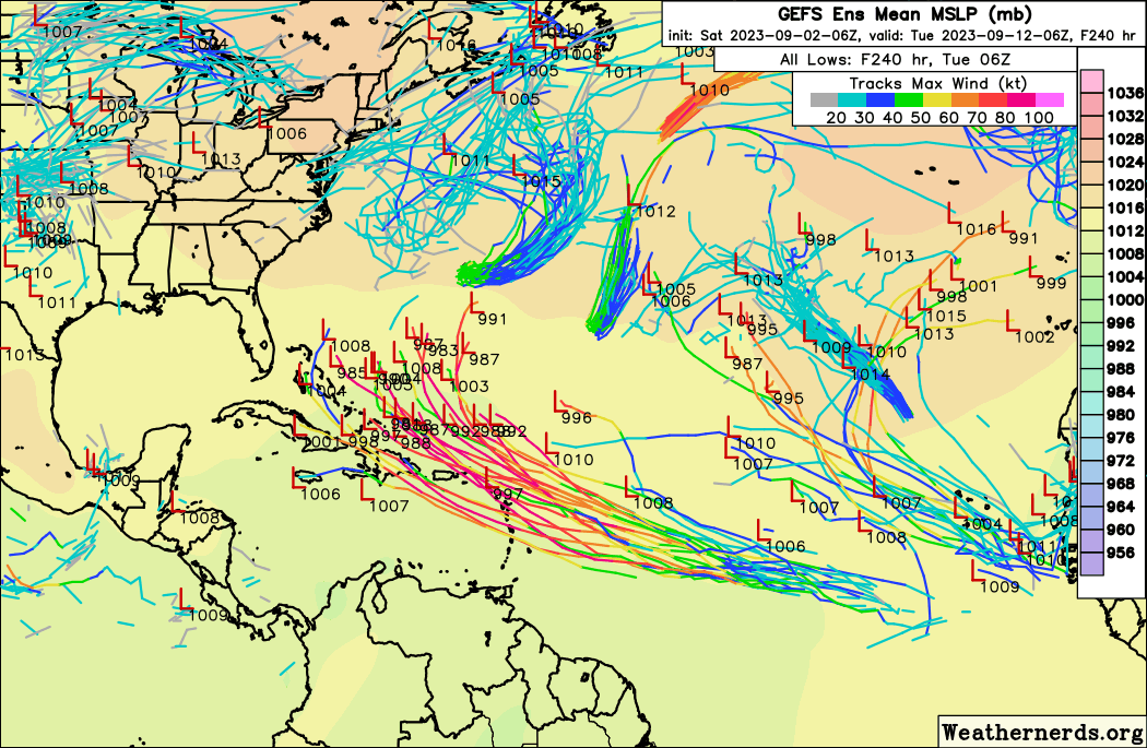


Last edited by SFLcane on Sat Sep 02, 2023 8:24 am, edited 1 time in total.
1 likes
Re: ATL: INVEST 95L - Models
Yes fantasy land territory at 10 days but definitely has the look and track of a major Cape Verde storm. Has model support from GFS, Euro, and CMC. Given the persistent troughing off the US east coast this summer we may be spared here in Florida but way too soon to even speculate on that now.
1 likes
-
emeraldislenc
- Category 2

- Posts: 524
- Joined: Fri Aug 24, 2012 4:49 pm
- Location: Emerald Isle NC
-
OuterBanker
- S2K Supporter

- Posts: 1704
- Joined: Wed Feb 26, 2003 10:53 am
- Location: Nags Head, NC
- Contact:
ATL: INVEST 95L - Discussion
Amazing agreement between GFS, Euro and CMC on a hurricane around 22N 68W on the 11th. Euro and GFS OTS around 70W just like Franklin.
0 likes
- toad strangler
- S2K Supporter

- Posts: 4162
- Joined: Sun Jul 28, 2013 3:09 pm
- Location: Earth
- Contact:
Re: ATL: INVEST 95L - Models
ronjon wrote:Yes fantasy land territory at 10 days but definitely has thelook and track of a major Cape Verde storm. Has model support from GFS, Euro, and CMC. Given the persistent troughing off the US east coast this summer we may be spared here in Florida but way too soon to even speculate on that now.
500mb is tough enough to nail down even 3 days out. I, being in the SW part of the basin, won't give a thought to upper steering for another 5 days or so. Our friends in the Lesser A's though should be like
2 likes
Re: ATL: INVEST 95L - Models
12z GFS seems to have dropped it in favor of the next wave, again.
1 likes
Irene '11 Sandy '12 Hermine '16 5/15/2018 Derecho Fay '20 Isaias '20 Elsa '21 Henri '21 Ida '21
I am only a meteorology enthusiast who knows a decent amount about tropical cyclones. Look to the professional mets, the NHC, or your local weather office for the best information.
I am only a meteorology enthusiast who knows a decent amount about tropical cyclones. Look to the professional mets, the NHC, or your local weather office for the best information.
Re: ATL: INVEST 95L - Models
IcyTundra wrote:12Z GFS slower to develop so far.
Not only does the GFS have very little with this so far, the CMC is similar. Plus the last few ICONs have been weaker than recent days. Also, the 0Z UK had no TC. Trend?
0 likes
Personal Forecast Disclaimer:
The posts in this forum are NOT official forecasts and should not be used as such. They are just the opinion of the poster and may or may not be backed by sound meteorological data. They are NOT endorsed by any professional institution or storm2k.org. For official information, please refer to the NHC and NWS products.
The posts in this forum are NOT official forecasts and should not be used as such. They are just the opinion of the poster and may or may not be backed by sound meteorological data. They are NOT endorsed by any professional institution or storm2k.org. For official information, please refer to the NHC and NWS products.
- SFLcane
- S2K Supporter

- Posts: 9606
- Age: 46
- Joined: Sat Jun 05, 2010 1:44 pm
- Location: Lake Worth Florida
Re: ATL: INVEST 95L - Models
LarryWx wrote:IcyTundra wrote:12Z GFS slower to develop so far.
Not only does the GFS have very little with this so far, the CMC is similar. Plus the last few ICONs have been weaker than recent days. Also, the 0Z UK had no TC. Trend?
Delayed development… we know what follows
1 likes
-
AutoPenalti
- Category 5

- Posts: 3949
- Age: 27
- Joined: Mon Aug 17, 2015 4:16 pm
- Location: Ft. Lauderdale, Florida
Re: ATL: INVEST 95L - Models
That weird looking low pressure seems to just be hanging around doing loops off the coast.
0 likes
The posts in this forum are NOT official forecasts and should not be used as such. They are just the opinion of the poster and may or may not be backed by sound meteorological data. They are NOT endorsed by any professional institution or STORM2K. For official information, please refer to products from the NHC and NWS.
Model Runs Cheat Sheet:
GFS (5:30 AM/PM, 11:30 AM/PM)
HWRF, GFDL, UKMET, NAVGEM (6:30-8:00 AM/PM, 12:30-2:00 AM/PM)
ECMWF (1:45 AM/PM)
TCVN is a weighted averaged
Re: ATL: INVEST 95L - Models
After many runs in a row showing TCG, the last two UK runs, including the new one (12Z), have no TCG. It goes out to 168.
0 likes
Personal Forecast Disclaimer:
The posts in this forum are NOT official forecasts and should not be used as such. They are just the opinion of the poster and may or may not be backed by sound meteorological data. They are NOT endorsed by any professional institution or storm2k.org. For official information, please refer to the NHC and NWS products.
The posts in this forum are NOT official forecasts and should not be used as such. They are just the opinion of the poster and may or may not be backed by sound meteorological data. They are NOT endorsed by any professional institution or storm2k.org. For official information, please refer to the NHC and NWS products.
-
AutoPenalti
- Category 5

- Posts: 3949
- Age: 27
- Joined: Mon Aug 17, 2015 4:16 pm
- Location: Ft. Lauderdale, Florida
Re: ATL: INVEST 95L - Models
FWIW it’s SE and weaker than 06z
0 likes
The posts in this forum are NOT official forecasts and should not be used as such. They are just the opinion of the poster and may or may not be backed by sound meteorological data. They are NOT endorsed by any professional institution or STORM2K. For official information, please refer to products from the NHC and NWS.
Model Runs Cheat Sheet:
GFS (5:30 AM/PM, 11:30 AM/PM)
HWRF, GFDL, UKMET, NAVGEM (6:30-8:00 AM/PM, 12:30-2:00 AM/PM)
ECMWF (1:45 AM/PM)
TCVN is a weighted averaged
Re: ATL: INVEST 95L - Models
Ridging to the north is stronger and reaches further south on latest run. This forces 95L south of PR.
1 likes
- cheezyWXguy
- Category 5

- Posts: 5532
- Joined: Mon Feb 13, 2006 12:29 am
- Location: Dallas, TX
Re: ATL: INVEST 95L - Models
Not buying any runs that don’t show development. Where it goes is a different story, but this thing is nearly classifiable already.
1 likes
-
AutoPenalti
- Category 5

- Posts: 3949
- Age: 27
- Joined: Mon Aug 17, 2015 4:16 pm
- Location: Ft. Lauderdale, Florida
Re: ATL: INVEST 95L - Models
Crashes into the islands.
0 likes
The posts in this forum are NOT official forecasts and should not be used as such. They are just the opinion of the poster and may or may not be backed by sound meteorological data. They are NOT endorsed by any professional institution or STORM2K. For official information, please refer to products from the NHC and NWS.
Model Runs Cheat Sheet:
GFS (5:30 AM/PM, 11:30 AM/PM)
HWRF, GFDL, UKMET, NAVGEM (6:30-8:00 AM/PM, 12:30-2:00 AM/PM)
ECMWF (1:45 AM/PM)
TCVN is a weighted averaged
Re: ATL: INVEST 95L - Models
CMC and ICON are weaker than yesterday’s 12z runs, and the CMC is far weaker with its other two MDR systems too.
0 likes
Irene '11 Sandy '12 Hermine '16 5/15/2018 Derecho Fay '20 Isaias '20 Elsa '21 Henri '21 Ida '21
I am only a meteorology enthusiast who knows a decent amount about tropical cyclones. Look to the professional mets, the NHC, or your local weather office for the best information.
I am only a meteorology enthusiast who knows a decent amount about tropical cyclones. Look to the professional mets, the NHC, or your local weather office for the best information.
- Kingarabian
- S2K Supporter

- Posts: 15434
- Joined: Sat Aug 08, 2009 3:06 am
- Location: Honolulu, Hawaii
Re: ATL: INVEST 95L - Models
Exceptional TCs moving W/WNW can easily pump the ridge to move SW. Usually goes unmodeled and can have big impacts on track forecast.
1 likes
RIP Kobe Bryant
Re: ATL: INVEST 95L - Models
I'm not sure why the models think it's July. Should be all systems go for this storm. And nobody should be predicting a recurve as of now.
1 likes
Who is online
Users browsing this forum: No registered users and 85 guests


