EPAC: JOVA - Post-Tropical - Discussion
Moderator: S2k Moderators
-
Sciencerocks
- Category 5

- Posts: 7286
- Age: 38
- Joined: Thu Jul 06, 2017 1:51 am
Re: EPAC: JOVA - Hurricane - Discussion
I am honestly thinking that this was probably 155 knots/904-906mb range. This thing was on the level of Katrina, Dorian, Pat, Lane, and Maria.
0 likes
-
Sciencerocks
- Category 5
- Posts: 7286
- Age: 38
- Joined: Thu Jul 06, 2017 1:51 am
Re: EPAC: JOVA - Hurricane - Discussion
Sciencerocks wrote:I am honestly thinking that this was probably 155 knots/904-906mb range. This thing was on the level of Katrina, Dorian, Pat, Lane, and Maria.
I am going to just say that this is me being conservative. This was a smaller wilma or pat like storm and probably 160+ knts and sub 900 pressure. We'll never know. It is just safe to stick with the 155knt.
My gut screams 892.
0 likes
-
cycloneye

- Admin

- Posts: 139081
- Age: 67
- Joined: Thu Oct 10, 2002 10:54 am
- Location: San Juan, Puerto Rico
Re: EPAC: JOVA - Hurricane - Discussion
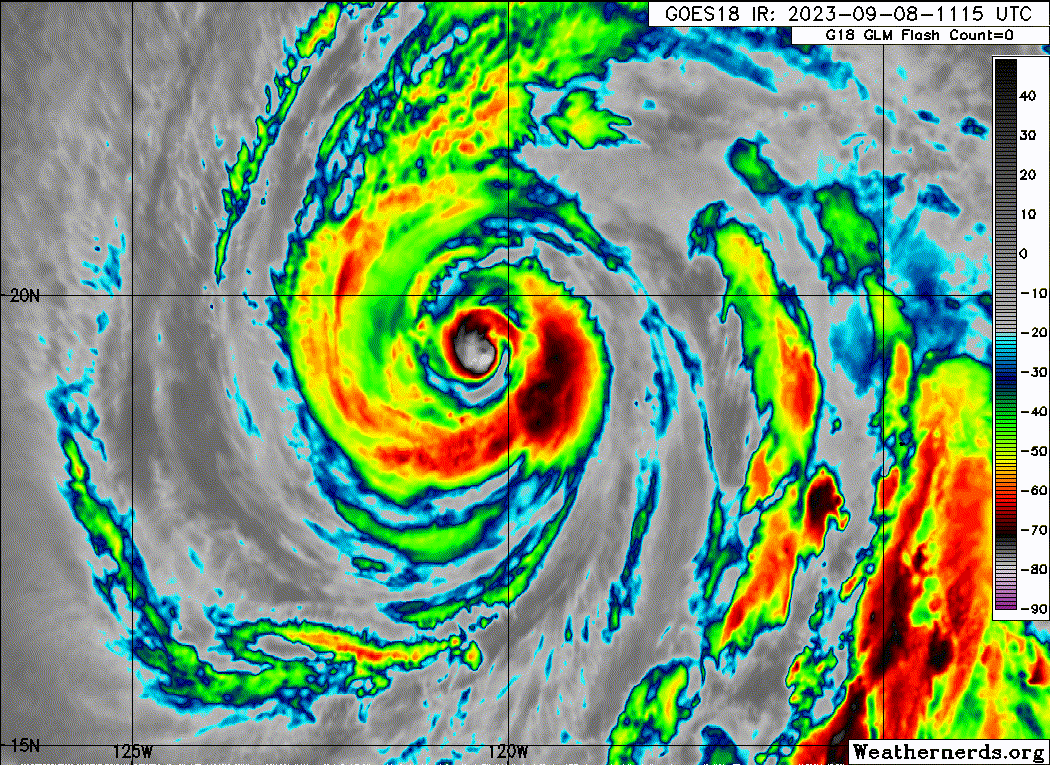
Hurricane Jova Discussion Number 15
NWS National Hurricane Center Miami FL EP112023
200 AM PDT Fri Sep 08 2023
Jova is continuing its weakening trend. A microwave pass from
around 0300 UTC still showed the remnants of a decaying eyewall
surrounded by a larger secondary eyewall. Recent geostationary
satellite imagery show dry slots working their way towards the inner
core and warming cloud top temperatures. As a result, subjective
and objective satellite estimates have been quickly decreasing. The
initial intensity has been set to 95 kt, which represents a blend
of the data-T and current intensity Dvorak estimates from TAFB and
SAB.
The hurricane is crossing over the 26 degree C isotherm and headed
towards even cooler ocean waters. Environmental conditions are also
expected to become increasingly hostile during the next few days.
The latest NHC forecast continues to show rapid to steady weakening
and is similar to the previous advisory, though has been adjusted
lower due to the decreased initial intensity. Jova will likely be a
remnant low by day 4, but this transition could occur sooner.
Jova is moving to the west-northwest at 14 kt. This general motion
is expected to continue for the next couple of days while Jova is
steered by a ridge centered over the southwestern United States. As
convection collapses, the weaker vortex is forecast to turn westward
to west-southwestward in the trade winds by the end of the forecast
period. The official track prediction has been shifted slightly
northward of the previous advisory and is a little slower at day 3
and beyond, keeping it close to the various consensus aids.
FORECAST POSITIONS AND MAX WINDS
INIT 08/0900Z 19.1N 119.7W 95 KT 110 MPH
12H 08/1800Z 20.0N 121.7W 85 KT 100 MPH
24H 09/0600Z 21.1N 123.9W 70 KT 80 MPH
36H 09/1800Z 22.5N 125.7W 55 KT 65 MPH
48H 10/0600Z 23.7N 127.0W 45 KT 50 MPH
60H 10/1800Z 24.6N 127.9W 40 KT 45 MPH
72H 11/0600Z 25.0N 128.7W 35 KT 40 MPH
96H 12/0600Z 25.0N 130.3W 30 KT 35 MPH...POST-TROP/REMNT LOW
120H 13/0600Z 24.6N 133.0W 25 KT 30 MPH...POST-TROP/REMNT LOW
$$
Forecaster Bucci
0 likes
Visit the Caribbean-Central America Weather Thread where you can find at first post web cams,radars
and observations from Caribbean basin members Click Here
and observations from Caribbean basin members Click Here

Re: EPAC: JOVA - Hurricane - Discussion
Sciencerocks wrote:Sciencerocks wrote:I am honestly thinking that this was probably 155 knots/904-906mb range. This thing was on the level of Katrina, Dorian, Pat, Lane, and Maria.
I am going to just say that this is me being conservative. This was a smaller wilma or pat like storm and probably 160+ knts and sub 900 pressure. We'll never know. It is just safe to stick with the 155knt.
My gut screams 892.
I would agree after seeing recon from Lee. Dvorak was likely horrible. It's overall structure was very much like Maria if not better.
1 likes
The above post and any post by Ntxw is NOT an official forecast and should not be used as such. It is just the opinion of the poster and may or may not be backed by sound meteorological data. It is NOT endorsed by any professional institution including Storm2k. For official information, please refer to NWS products.
Help support Storm2K!

-
Kingarabian

- S2K Supporter

- Posts: 15434
- Joined: Sat Aug 08, 2009 3:06 am
- Location: Honolulu, Hawaii
Re: EPAC: JOVA - Hurricane - Discussion
Comparing this to Lee, yes, this was likely closer to Patricia/Wilma/Haiyan/Goni than we previously thought.
1 likes
RIP Kobe Bryant
-
Sciencerocks
- Category 5
- Posts: 7286
- Age: 38
- Joined: Thu Jul 06, 2017 1:51 am
-
REDHurricane

- Tropical Storm

- Posts: 206
- Age: 26
- Joined: Sun Jul 03, 2022 2:36 pm
- Location: Northeast Pacific Ocean
Re: EPAC: JOVA - Hurricane - Discussion
Honestly I'd guess that Jova reached 170-175 knots/~890mb at its absolute peak, the entire core was literally vibrating on the hi-res satellite view. Easily the most impressive tropical cyclone I've seen since Goni
2 likes
-
Hurricane2022

- Category 4

- Posts: 921
- Joined: Tue Aug 23, 2022 11:38 pm
- Location: Araçatuba, Brazil
Re: EPAC: JOVA - Hurricane - Discussion
I think the appearance of Hurricane Jova in its peak very similar to Hurricane Wilma. I estimate a peak intensity of around 160 kt/895 mbar, making it the 2nd strongest storm in the history of the East Pacific, unofficially. It is very likely that this was not the peak of intensity, but without recon obviously we will not know the truth.
That said, the NHC will most likely stick with the 140 kt/929 mb estimate in the TCR, much like they did with Marie in 2014 as well.
That said, the NHC will most likely stick with the 140 kt/929 mb estimate in the TCR, much like they did with Marie in 2014 as well.
2 likes
Sorry for the bad English sometimes...!
For reliable and detailed information for any meteorological phenomenon, please consult the National Hurricane Center, Joint Typhoon Warning Center , or your local Meteo Center.
--------
Una cvm Christo, pro Christo, et in Christo. Sit nomen Domini benedictvm.
For reliable and detailed information for any meteorological phenomenon, please consult the National Hurricane Center, Joint Typhoon Warning Center , or your local Meteo Center.
--------
Una cvm Christo, pro Christo, et in Christo. Sit nomen Domini benedictvm.
-
cycloneye
- Admin
- Posts: 139081
- Age: 67
- Joined: Thu Oct 10, 2002 10:54 am
- Location: San Juan, Puerto Rico
Re: EPAC: JOVA - Hurricane - Discussion
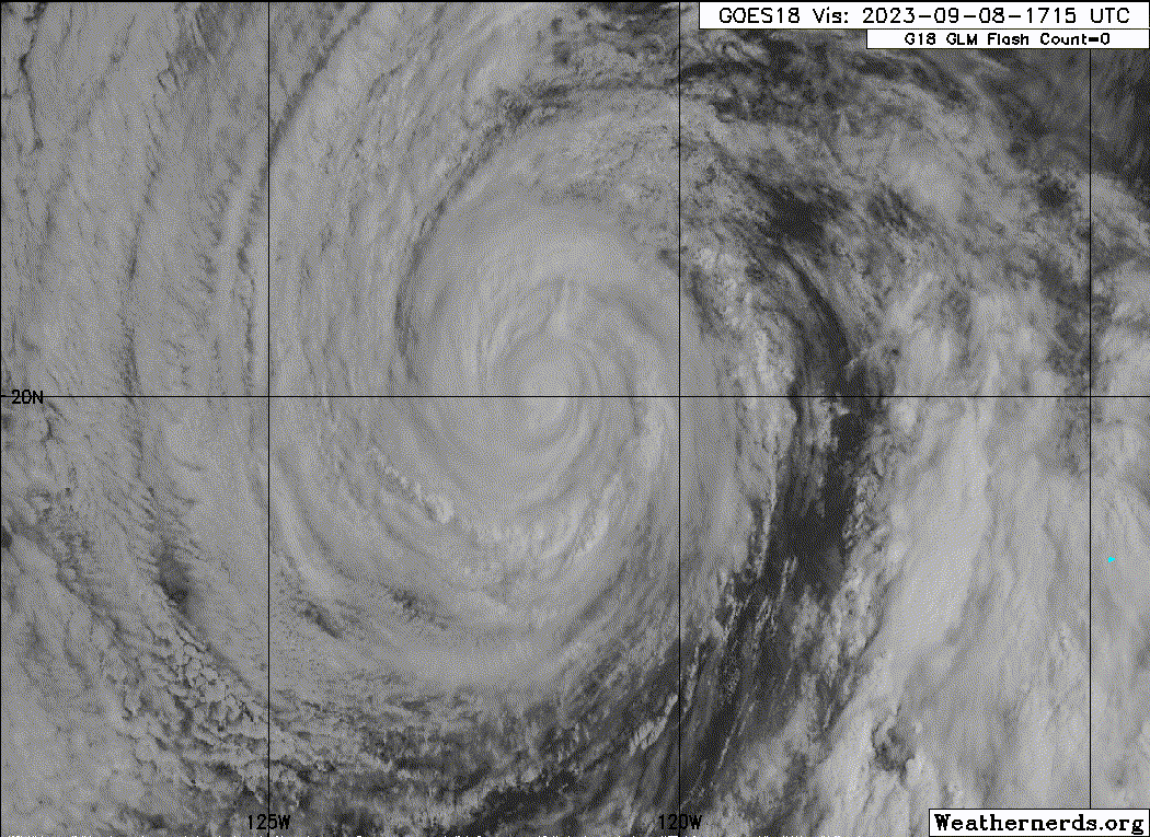
Hurricane Jova Discussion Number 16
NWS National Hurricane Center Miami FL EP112023
800 AM PDT Fri Sep 08 2023
Jova continues to weaken as it moves over cooler waters. An earlier
microwave SSMIS pass showed that the inner core of Jova continues to
erode with a secondary eyewall becoming the primary feature. GOES-18
Hi-res 1-minute satellite imagery depicts dry slots continue to work
their way into the inner core of the system. The drier air has also
started to cause breaks in some of the banding features around Jova.
As a result, subjective and objective satellite estimates have been
quickly decreasing. The initial intensity has been set to 85 kt,
which represents a blend of the data-T and current intensity Dvorak
estimates from TAFB and SAB.
The hurricane is crossing a sharp sea surface temperature gradient
into much cooler waters. Environmental conditions also become less
favorable over the next few days. The latest NHC forecast continues
to show rapid to steady weakening and is similar to the previous
advisory. The GFS and ECMWF simulated satellite show the system
becoming devoid of convection in about 3 days, and Jova is now
forecast to become a post-tropical remnant low at that time.
Jova is moving to the west-northwest at 14 kt. This general motion
is expected to continue for the next couple of days while the
cyclone rounds the end of a ridge centered over the southwestern
United States. As Jova weakens, the system is forecast to turn
westward to west-southwestward into the low-level flow towards the
end of the forecast period. The NHC track forecast is very close to
the previous advisory, and lies near the consensus aids.
FORECAST POSITIONS AND MAX WINDS
INIT 08/1500Z 19.8N 121.2W 85 KT 100 MPH
12H 09/0000Z 20.7N 123.1W 70 KT 80 MPH
24H 09/1200Z 22.0N 125.1W 55 KT 65 MPH
36H 10/0000Z 23.3N 126.6W 45 KT 50 MPH
48H 10/1200Z 24.3N 127.5W 40 KT 45 MPH
60H 11/0000Z 25.1N 128.2W 35 KT 40 MPH
72H 11/1200Z 25.3N 129.3W 30 KT 35 MPH...POST-TROP/REMNT LOW
96H 12/1200Z 24.8N 131.3W 25 KT 30 MPH...POST-TROP/REMNT LOW
120H 13/1200Z 24.1N 133.9W 20 KT 25 MPH...POST-TROP/REMNT LOW
$$
Forecaster Kelly/Brown
0 likes
Visit the Caribbean-Central America Weather Thread where you can find at first post web cams,radars
and observations from Caribbean basin members Click Here
and observations from Caribbean basin members Click Here
-
Yellow Evan

- Professional-Met

- Posts: 15952
- Age: 25
- Joined: Fri Jul 15, 2011 12:48 pm
- Location: Henderson, Nevada/Honolulu, HI
- Contact:
Re: EPAC: JOVA - Hurricane - Discussion
Classic case of post-pinhole drawn out ERC. Not helping this is over 25C SSTs and high RH% and low wind shear are favoring the formation of banding.
0 likes
-
cycloneye
- Admin
- Posts: 139081
- Age: 67
- Joined: Thu Oct 10, 2002 10:54 am
- Location: San Juan, Puerto Rico
Re: EPAC: JOVA - Hurricane - Discussion
Hurricane Jova Discussion Number 17
NWS National Hurricane Center Miami FL EP112023
200 PM PDT Fri Sep 08 2023
Jova continues to weaken as it encounters cooler sea surface
temperatures. The overall satellite depiction of Jova is that of a
weakening tropical system, encountering a more stable environment.
A SSMIS microwave pass that came in just after the previous
advisory, shows that banding around Jova is thinning, and the inner
core is collapsing as dry air wraps into the system. Cloud tops
within the convection have been warming throughout the day as well.
Subjective and objective satellite estimates have continued to
decrease throughout the day. The initial intensity has been set to
75 kt, which represents a blend of the data-T and current intensity
Dvorak estimates from TAFB and SAB.
Environmental conditions along the forecast track are becoming less
favorable, as the hurricane is moving over cool sea surface
temperatures and into a more stable airmass. The latest NHC forecast
continues to show steady weakening and is similar to the previous
advisory. The GFS and ECMWF simulated satellite show the system
becoming devoid of convection in about 3 days, and Jova is forecast
to become a post-tropical remnant low at that time.
Jova is moving to the west-northwest at 13 kt. This general motion
with a decrease in forward speed is expected to continue for the
next couple of days while the cyclone rounds the end of a ridge
centered over the southwestern United States. As Jova weakens, the
system is forecast to turn westward to west-southwestward into the
low-level flow towards the end of the forecast period. The NHC track
forecast is close to the previous advisory, just slightly slower
and lies near the consensus aids.
FORECAST POSITIONS AND MAX WINDS
INIT 08/2100Z 20.4N 122.4W 75 KT 85 MPH
12H 09/0600Z 21.3N 124.1W 60 KT 70 MPH
24H 09/1800Z 22.6N 125.9W 50 KT 60 MPH
36H 10/0600Z 23.8N 127.1W 40 KT 45 MPH
48H 10/1800Z 24.6N 128.0W 35 KT 40 MPH
60H 11/0600Z 24.9N 128.9W 30 KT 35 MPH
72H 11/1800Z 24.6N 129.8W 25 KT 30 MPH...POST-TROP/REMNT LOW
96H 12/1800Z 24.1N 132.1W 25 KT 30 MPH...POST-TROP/REMNT LOW
120H 13/1800Z...DISSIPATED
$$
Forecaster Kelly
0 likes
Visit the Caribbean-Central America Weather Thread where you can find at first post web cams,radars
and observations from Caribbean basin members Click Here
and observations from Caribbean basin members Click Here
-
Sciencerocks
- Category 5
- Posts: 7286
- Age: 38
- Joined: Thu Jul 06, 2017 1:51 am

Re: EPAC: JOVA - Hurricane - Discussion
Just took a look at a panned out view of the EPAC, and wow, Jova is absolutely huge.
0 likes
-
Sciencerocks
- Category 5
- Posts: 7286
- Age: 38
- Joined: Thu Jul 06, 2017 1:51 am

-
cycloneye
- Admin
- Posts: 139081
- Age: 67
- Joined: Thu Oct 10, 2002 10:54 am
- Location: San Juan, Puerto Rico
Re: EPAC: JOVA - Hurricane - Discussion
Hurricane Jova Discussion Number 18
NWS National Hurricane Center Miami FL EP112023
800 PM PDT Fri Sep 08 2023
Jova's steady decline has continued as the hurricane moves over
cooler waters. Cloud tops have warmed, and the last hints of an eye
have disappeared in all geostationary imagery. A blend of subjective
and objective satellite intensity estimates supported an intensity
of 70 kt at 00 UTC. The 65 kt advisory intensity assumes a little
futher weakening has happened since then. Additional weakening will
continue during the next few days, primarily due to the cool waters
beneath Jova and a drying environment. Most models indicate that
Jova will lose its deep convection and become a remnant low near or
just after 60 h, which is reflected in the NHC intensity forecast.
The track forecast remains straightforward. For the next 2 days or
so, Jova will continue moving generally northwestward, steered by a
deep ridge that extends from the southwestern U.S. across the
eastern 2/3 of the basin. As Jova loses its deep convection, it
should slow down and turn westward, and then west-southwestward
within low-level flow. Model guidance, both for track and intensity,
is in very good agreement on Jova's evolution during the next few
days and confidence in the forecast is high. No significant changes
to the NHC forecast were required for this advisory.
FORECAST POSITIONS AND MAX WINDS
INIT 09/0300Z 21.1N 123.7W 65 KT 75 MPH
12H 09/1200Z 22.0N 125.2W 55 KT 65 MPH
24H 10/0000Z 23.3N 126.7W 45 KT 50 MPH
36H 10/1200Z 24.3N 127.6W 40 KT 45 MPH
48H 11/0000Z 24.8N 128.4W 35 KT 40 MPH
60H 11/1200Z 24.8N 129.3W 30 KT 35 MPH
72H 12/0000Z 24.5N 130.2W 25 KT 30 MPH...POST-TROP/REMNT LOW
96H 13/0000Z 23.5N 133.0W 25 KT 30 MPH...POST-TROP/REMNT LOW
120H 14/0000Z...DISSIPATED
$$
Forecaster D. Zelinsky
0 likes
Visit the Caribbean-Central America Weather Thread where you can find at first post web cams,radars
and observations from Caribbean basin members Click Here
and observations from Caribbean basin members Click Here
-
cycloneye
- Admin
- Posts: 139081
- Age: 67
- Joined: Thu Oct 10, 2002 10:54 am
- Location: San Juan, Puerto Rico
Re: EPAC: JOVA - Tropical storm - Discussion
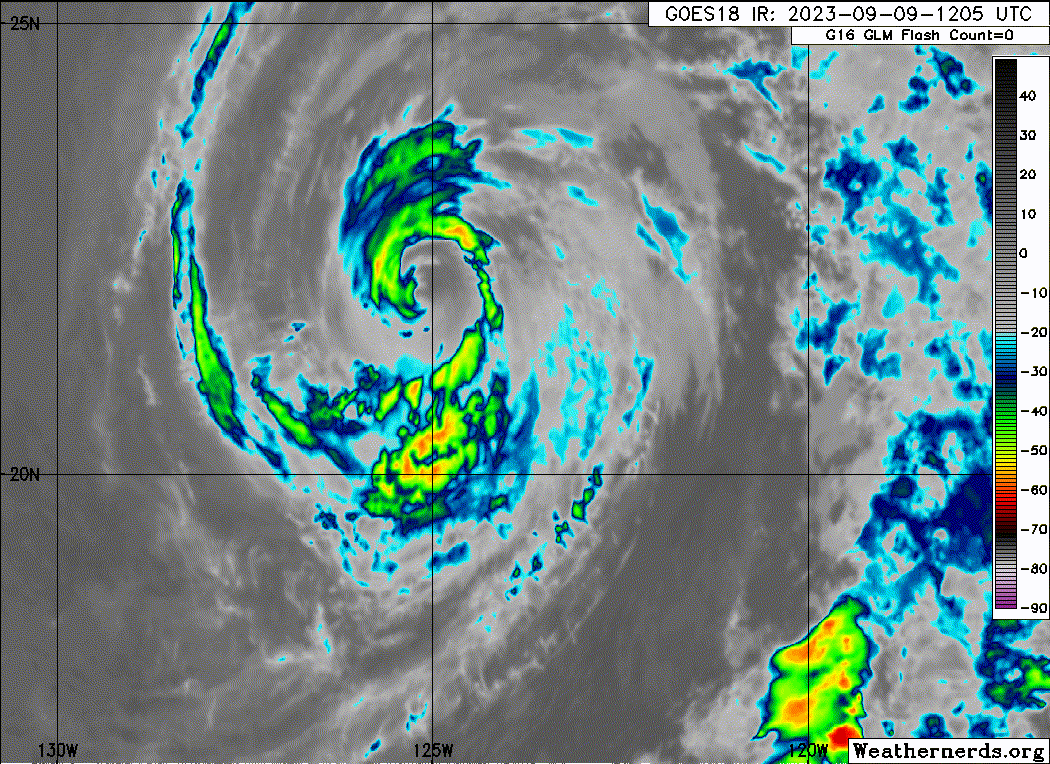
Tropical Storm Jova Discussion Number 19
NWS National Hurricane Center Miami FL EP112023
200 AM PDT Sat Sep 09 2023
This morning's satellite presentation consists of a deteriorating
cloud pattern with what remains of the deep convection confined to
the western half of the cyclone. A blend of the subjective and
objective intensity estimates yield an initial intensity of 60 kt
for this advisory.
Jova is forecast to spin down slowly during the next few days,
while traversing decreasing oceanic surface temperatures and moving
into a high, statically stable surrounding environment. Most models
indicate that Jova will lose its deep convection and become a
remnant low in 60 hours, which is shown in the NHC intensity
forecast.
The initial motion is estimated to be west-northwestward, 300/11 kt.
The NHC forecast track philosophy remains unchanged. Jova should
continue to move generally toward that northwest within the
southeasterly mid-tropospheric flow produced by subtropical high
pressure that stretches from the southwestern U.S. across most of
the eastern Pacific. As Jova sheds its associated deep convection
and degenerates to a vertically shallow cyclone, Jova is expected to
decrease in forward speed and turn toward the west, and
west-southwest within the easterly tradewind flow through
dissipation.
FORECAST POSITIONS AND MAX WINDS
INIT 09/0900Z 21.5N 124.6W 60 KT 70 MPH
12H 09/1800Z 22.3N 125.8W 50 KT 60 MPH
24H 10/0600Z 23.4N 126.8W 40 KT 45 MPH
36H 10/1800Z 24.3N 127.5W 35 KT 40 MPH
48H 11/0600Z 24.6N 128.5W 30 KT 35 MPH
60H 11/1800Z 24.3N 129.2W 25 KT 30 MPH...POST-TROP/REMNT LOW
72H 12/0600Z 23.9N 130.3W 25 KT 30 MPH...POST-TROP/REMNT LOW
96H 13/0600Z 22.7N 133.9W 25 KT 30 MPH...POST-TROP/REMNT LOW
120H 14/0600Z...DISSIPATED
$$
Forecaster Roberts
0 likes
Visit the Caribbean-Central America Weather Thread where you can find at first post web cams,radars
and observations from Caribbean basin members Click Here
and observations from Caribbean basin members Click Here
-
Sciencerocks
- Category 5
- Posts: 7286
- Age: 38
- Joined: Thu Jul 06, 2017 1:51 am
-
cycloneye
- Admin
- Posts: 139081
- Age: 67
- Joined: Thu Oct 10, 2002 10:54 am
- Location: San Juan, Puerto Rico
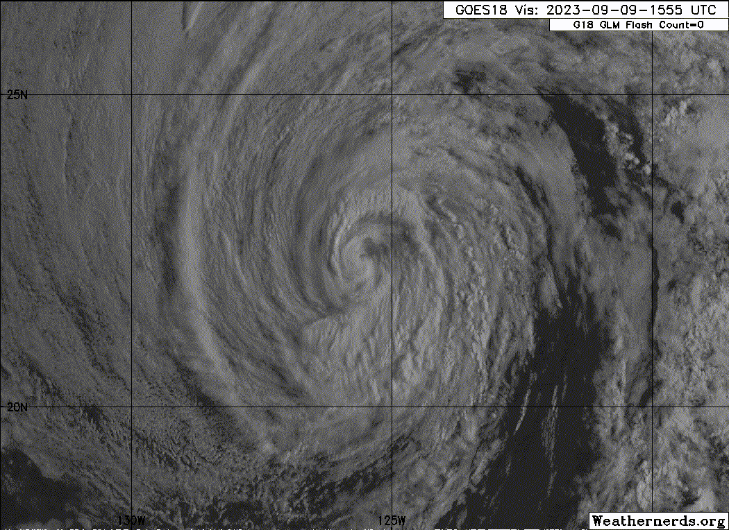
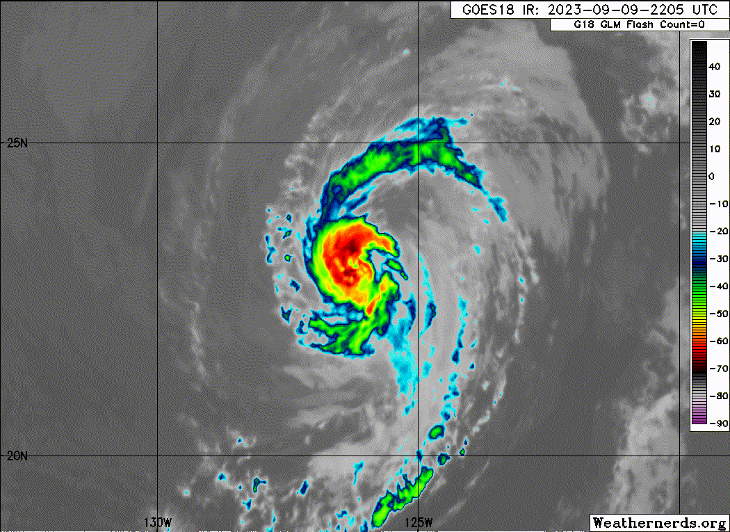
Re: EPAC: JOVA - Tropical storm - Discussion
Tropical Storm Jova Discussion Number 20
NWS National Hurricane Center Miami FL EP112023
800 AM PDT Sat Sep 09 2023
Jova continues to deteriorate in latest satellite imagery. Dry air
continues to work into this system, with deep convection starting
to dissipate. Broken convective banding around the system is
deteriorating with warming cloud tops in infrared satellite imagery
A blend of subjective and objective satellite intensity estimates
suggest an intensity of 55 kt, which is the initial intensity for
this advisory.
Jova is forecast to continue weakening during the next several days
as the system moves over cool sea surface temperatures, and into a
more stable airmass. Simulated satellite from the GFS and ECMWF
suggest Jova will be devoid of deep convection and become a remnant
low in about 48 hours, this is reflected in the NHC intensity
forecast. However, the transition to a remnant low could occur
sooner than forecast.
The initial motion is estimated to be northwestward at 9 kt. Jova
should continue to move generally toward the northwest around the
edge of a subtropical ridge located over the southwestern United
States. As Jova weakens, the system is forecast to turn westward to
west-southwestward into the low-level flow through the end of the
forecast period. The NHC track forecast is similar to the previous
forecast track.
FORECAST POSITIONS AND MAX WINDS
INIT 09/1500Z 22.3N 125.5W 55 KT 65 MPH
12H 10/0000Z 23.3N 126.6W 45 KT 50 MPH
24H 10/1200Z 24.2N 127.5W 35 KT 40 MPH
36H 11/0000Z 24.7N 128.4W 30 KT 35 MPH
48H 11/1200Z 24.8N 129.1W 25 KT 30 MPH...POST-TROP/REMNT LOW
60H 12/0000Z 24.4N 130.1W 25 KT 30 MPH...POST-TROP/REMNT LOW
72H 12/1200Z 23.8N 131.5W 25 KT 30 MPH...POST-TROP/REMNT LOW
96H 13/1200Z...DISSIPATED
$$
Forecaster Kelly
0 likes
Visit the Caribbean-Central America Weather Thread where you can find at first post web cams,radars
and observations from Caribbean basin members Click Here
and observations from Caribbean basin members Click Here
-
Sciencerocks
- Category 5
- Posts: 7286
- Age: 38
- Joined: Thu Jul 06, 2017 1:51 am
-
Sciencerocks
- Category 5
- Posts: 7286
- Age: 38
- Joined: Thu Jul 06, 2017 1:51 am
Who is online
Users browsing this forum: No registered users and 78 guests