ATL: SEAN - Remnants - Discussion

Moderator: S2k Moderators

Message
Author
User avatar
aspen
Category 5
Category 5
Posts: 8057
Joined: Sat Oct 12, 2019 7:10 pm
Location: Connecticut, USA

Re: ATL: SEAN - Tropical Storm - Discussion

#61 Postby aspen » Wed Oct 11, 2023 5:36 am

al78 wrote:Another weak storm that has little prospects to add to the collection. That is now a 3:1 ratio of named storms to hurricanes, quite high. Despite the very warm SSTs this year the MDR hasn't been favourable for tropical cyclone intensification.

The fact that we’ve seen so much MDR genesis in an El Niño year is pretty impressive, and we’re already up to 19 NS and 130 ACE. Getting a MDR storm in October is also impressive regardless of ENSO state.
1 likes   
Irene '11 Sandy '12 Hermine '16 5/15/2018 Derecho Fay '20 Isaias '20 Elsa '21 Henri '21 Ida '21

I am only a meteorology enthusiast who knows a decent amount about tropical cyclones. Look to the professional mets, the NHC, or your local weather office for the best information.

User avatar
wxman57
Moderator-Pro Met
Moderator-Pro Met
Posts: 22482
Age: 66
Joined: Sat Jun 21, 2003 8:06 pm
Location: Houston, TX (southwest)

Re: ATL: SEAN - Tropical Storm - Discussion

#62 Postby wxman57 » Wed Oct 11, 2023 7:00 am

aspen wrote:
al78 wrote:Another weak storm that has little prospects to add to the collection. That is now a 3:1 ratio of named storms to hurricanes, quite high. Despite the very warm SSTs this year the MDR hasn't been favourable for tropical cyclone intensification.

The fact that we’ve seen so much MDR genesis in an El Niño year is pretty impressive, and we’re already up to 19 NS and 130 ACE. Getting a MDR storm in October is also impressive regardless of ENSO state.


I think the fact that all storms struggled in the MDR this season is a sure sign of an El Niño impact. Sean will be another weak, short-lived storm in the MDR. Just too much shear there this season. I was surprised that the NHC upgraded 92L overnight. It's about as disorganized as a TS can be. I don't think it'll last as long as the NHC indicates.
2 likes   

al78
Professional-Met
Professional-Met
Posts: 249
Joined: Thu Nov 01, 2018 12:20 pm

Re: ATL: SEAN - Tropical Storm - Discussion

#63 Postby al78 » Wed Oct 11, 2023 7:31 am

aspen wrote:
al78 wrote:Another weak storm that has little prospects to add to the collection. That is now a 3:1 ratio of named storms to hurricanes, quite high. Despite the very warm SSTs this year the MDR hasn't been favourable for tropical cyclone intensification.

The fact that we’ve seen so much MDR genesis in an El Niño year is pretty impressive, and we’re already up to 19 NS and 130 ACE. Getting a MDR storm in October is also impressive regardless of ENSO state.


Numbers are high but numbers alone don't tell the full story. 130 ACE isn't very high for a season with 19 named storms. It is happening more often because weak short lived/disorganised storms are being called more frequently than decades ago due to better instrumentation. If you looked at number of hurricane days in the MDR region alone I reckon it would be more typical of a below-normal season and characteristic of an El Nino influenced season. There seems to be a similarity to 2018 which was also an active season with a very similar ACE to this season to date, but where storms (largely) didn't develop into hurricanes until they moved out of the MDR into the sub-tropics. Another notable feature this year is the lack of anything significant developing or moving into the Caribbean Sea.
1 likes   

WeatherBoy2000
Tropical Depression
Tropical Depression
Posts: 88
Joined: Mon Apr 10, 2023 9:29 am

Re: ATL: SEAN - Tropical Storm - Discussion

#64 Postby WeatherBoy2000 » Wed Oct 11, 2023 8:20 am

al78 wrote:
aspen wrote:
al78 wrote:Another weak storm that has little prospects to add to the collection. That is now a 3:1 ratio of named storms to hurricanes, quite high. Despite the very warm SSTs this year the MDR hasn't been favourable for tropical cyclone intensification.

The fact that we’ve seen so much MDR genesis in an El Niño year is pretty impressive, and we’re already up to 19 NS and 130 ACE. Getting a MDR storm in October is also impressive regardless of ENSO state.


Numbers are high but numbers alone don't tell the full story. 130 ACE isn't very high for a season with 19 named storms. It is happening more often because weak short lived/disorganised storms are being called more frequently than decades ago due to better instrumentation. If you looked at number of hurricane days in the MDR region alone I reckon it would be more typical of a below-normal season and characteristic of an El Nino influenced season. There seems to be a similarity to 2018 which was also an active season with a very similar ACE to this season to date, but where storms (largely) didn't develop into hurricanes until they moved out of the MDR into the sub-tropics. Another notable feature this year is the lack of anything significant developing or moving into the Caribbean Sea.


This is like 2019/2021 again, many storms but only around an average amount of hurricanes. Lee is the only hurricane this season to develop south of 20N, for reference 2018 had four. It seems like a mix of non-existent ridging and subtle el nino influence is to blame for this. However, for a strong el nino, the season's performance has been impressive. Every strong el nino prior to this year hasn't had even close to this level of activity, whether it be by ace or storm count, and the season isn't even over yet.

Who knows Ophelia, Bret, and Jose might see a post season upgrade to hurricane status.
2 likes   

User avatar
cycloneye
Admin
Admin
Posts: 139087
Age: 67
Joined: Thu Oct 10, 2002 10:54 am
Location: San Juan, Puerto Rico

Re: ATL: SEAN - Tropical Storm - Discussion

#65 Postby cycloneye » Wed Oct 11, 2023 8:25 am

AL, 19, 2023101112, , BEST, 0, 105N, 340W, 35, 1006, TS
0 likes   
Visit the Caribbean-Central America Weather Thread where you can find at first post web cams,radars
and observations from Caribbean basin members Click Here

User avatar
Teban54
Category 5
Category 5
Posts: 1958
Joined: Sat May 19, 2018 1:19 pm

Re: ATL: SEAN - Tropical Storm - Discussion

#66 Postby Teban54 » Wed Oct 11, 2023 8:35 am

al78 wrote:130 ACE isn't very high for a season with 19 named storms.

This is literally not how ACE works, because storms like Emily, Jose and Katia generate minimal ACE. I don't understand why people think a 19/6/3 season with 130 ACE is somehow less active than a "normal TS-H ratio" 12/6/3 season with say 120 ACE.

al78 wrote: If you looked at number of hurricane days in the MDR region alone I reckon it would be more typical of a below-normal season and characteristic of an El Nino influenced season.

2005 had below-average H days within MDR proper. In fact, the only hurricane within MDR was Philippe '05, a short-lived Cat 1.

Btw, 2023 has above-average H count and H days, using the (inflated IMO) 1991-2020 climo.

al78 wrote:Another notable feature this year is the lack of anything significant developing or moving into the Caribbean Sea.

Franklin and Idalia both developed in the Caribbean, and later peaked as Cat 4s.
0 likes   

Sciencerocks
Category 5
Category 5
Posts: 7286
Age: 38
Joined: Thu Jul 06, 2017 1:51 am

Re: ATL: SEAN - Tropical Storm - Discussion

#67 Postby Sciencerocks » Wed Oct 11, 2023 11:48 am

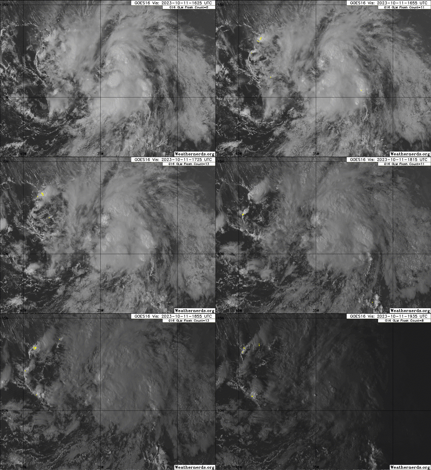
Image
0 likes   

User avatar
Teban54
Category 5
Category 5
Posts: 1958
Joined: Sat May 19, 2018 1:19 pm

Re: ATL: SEAN - Tropical Storm - Discussion

#68 Postby Teban54 » Wed Oct 11, 2023 12:34 pm


Looks too good for a future 40 kts peak, but that's just me.
0 likes   

al78
Professional-Met
Professional-Met
Posts: 249
Joined: Thu Nov 01, 2018 12:20 pm

Re: ATL: SEAN - Tropical Storm - Discussion

#69 Postby al78 » Wed Oct 11, 2023 2:01 pm

Teban54 wrote:
al78 wrote:130 ACE isn't very high for a season with 19 named storms.

This is literally not how ACE works, because storms like Emily, Jose and Katia generate minimal ACE. I don't understand why people think a 19/6/3 season with 130 ACE is somehow less active than a "normal TS-H ratio" 12/6/3 season with say 120 ACE.

al78 wrote: If you looked at number of hurricane days in the MDR region alone I reckon it would be more typical of a below-normal season and characteristic of an El Nino influenced season.

2005 had below-average H days within MDR proper. In fact, the only hurricane within MDR was Philippe '05, a short-lived Cat 1.

Btw, 2023 has above-average H count and H days, using the (inflated IMO) 1991-2020 climo.

al78 wrote:Another notable feature this year is the lack of anything significant developing or moving into the Caribbean Sea.

Franklin and Idalia both developed in the Caribbean, and later peaked as Cat 4s.


Your first point is not something I am claiming, I was saying looking at storm numbers alone does not give the full picture. 2017 had two fewer named storms than this year but an ACE index nearly 100 units higher, because several storms that year developed into strong hurricanes and had long tracks. This year has been characterised with a fair few storms that have developed and then forever struggled throughout their life, which is indicative of transient favourable conditions rather than frequent favourable conditions normally associated with an active season.

The second point, I was thinking of hurricane days only for the portion of the storm tracks that were within the MDR box (10-20N, 60-20W) which looks lower than normal to me although I don't have the numbers to be certain. As for 2005, that was unusual in having an extreme bias towards the Caribbean and Gulf, there was little in the MDR itself, again like 2018 the hurricanes that formed outside the Caribbean/Gulf mostly formed in the sub-tropical Atlantic, not the tropical Atlantic.

The third point, Franklin developed in the Caribbean but was a weak storm until it moved into the sub-tropics east of Florida where it strengthened into a cat 4, which is similar to storms that developed in the MDR in 2018. This suggests sub-optimal conditions on average for hurricane development in the deep tropics this year. Idalia is the one storm that was a significant hurricane in the Caribbean/Gulf region.
0 likes   

Sciencerocks
Category 5
Category 5
Posts: 7286
Age: 38
Joined: Thu Jul 06, 2017 1:51 am

Re: ATL: SEAN - Tropical Storm - Discussion

#70 Postby Sciencerocks » Wed Oct 11, 2023 2:54 pm

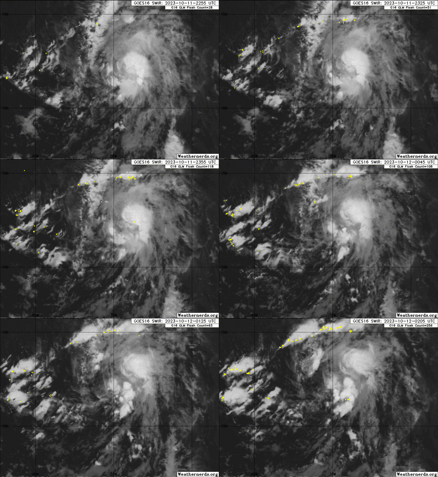
Image
0 likes   

User avatar
aspen
Category 5
Category 5
Posts: 8057
Joined: Sat Oct 12, 2019 7:10 pm
Location: Connecticut, USA

Re: ATL: SEAN - Tropical Storm - Discussion

#71 Postby aspen » Wed Oct 11, 2023 8:25 pm

Down to a TD. Whomp.
0 likes   
Irene '11 Sandy '12 Hermine '16 5/15/2018 Derecho Fay '20 Isaias '20 Elsa '21 Henri '21 Ida '21

I am only a meteorology enthusiast who knows a decent amount about tropical cyclones. Look to the professional mets, the NHC, or your local weather office for the best information.

User avatar
cycloneye
Admin
Admin
Posts: 139087
Age: 67
Joined: Thu Oct 10, 2002 10:54 am
Location: San Juan, Puerto Rico

Re: ATL: SEAN - Tropical Storm - Discussion

#72 Postby cycloneye » Wed Oct 11, 2023 9:00 pm

Didn't last very long as a TS.

AL, 19, 2023101200, , BEST, 0, 118N, 358W, 30, 1007, TD
0 likes   
Visit the Caribbean-Central America Weather Thread where you can find at first post web cams,radars
and observations from Caribbean basin members Click Here

Sciencerocks
Category 5
Category 5
Posts: 7286
Age: 38
Joined: Thu Jul 06, 2017 1:51 am

Re: ATL: SEAN - Tropical Storm - Discussion

#73 Postby Sciencerocks » Wed Oct 11, 2023 9:16 pm

Image
0 likes   

MarioProtVI
Category 2
Category 2
Posts: 670
Age: 22
Joined: Sun Sep 29, 2019 7:33 pm
Location: New Jersey

Re: ATL: SEAN - Tropical Depression - Discussion

#74 Postby MarioProtVI » Wed Oct 11, 2023 10:37 pm

NHC further making my previous point very clear. This never got beyond 30 kt and has remained a depression all day. Strongly think they should downgrade to TD in TCR.
0 likes   

User avatar
KirbyDude25
Tropical Storm
Tropical Storm
Posts: 117
Age: 19
Joined: Mon Sep 20, 2021 8:03 am

Re: ATL: SEAN - Tropical Depression - Discussion

#75 Postby KirbyDude25 » Wed Oct 11, 2023 11:50 pm

MarioProtVI wrote:NHC further making my previous point very clear. This never got beyond 30 kt and has remained a depression all day. Strongly think they should downgrade to TD in TCR.

If they did downgrade it, would it still keep the name Sean, or would it retroactively get its name stripped? It makes sense for post-season upgrades (like 90L back in January) to not get named since that wouldn't fit within the order, but what's the policy for post-season downgrades?
0 likes   
New Jersey, Rutgers '27
Irene 2011 | Sandy 2012 | Fay 2020 | Isaias 2020 | Ida 2021

MarioProtVI
Category 2
Category 2
Posts: 670
Age: 22
Joined: Sun Sep 29, 2019 7:33 pm
Location: New Jersey

Re: ATL: SEAN - Tropical Depression - Discussion

#76 Postby MarioProtVI » Thu Oct 12, 2023 12:37 am

KirbyDude25 wrote:
MarioProtVI wrote:NHC further making my previous point very clear. This never got beyond 30 kt and has remained a depression all day. Strongly think they should downgrade to TD in TCR.

If they did downgrade it, would it still keep the name Sean, or would it retroactively get its name stripped? It makes sense for post-season upgrades (like 90L back in January) to not get named since that wouldn't fit within the order, but what's the policy for post-season downgrades?

It’s a gray area but there was at least 2 cases where NHC has been in such a position. Kendra 1966 was initially named as a TS, then was removed and classified as non-tropical in post-analysis, and then was readded after the HURDAT re-analysis project found it was actually a TS. The only other case in more recent times and probably the best analog is Gaston 2010, which, like Sean, supposedly became a TS and then immediately weakened back to a depression, and NHC even admitted in its TCR that it was probably never a TS to begin with, since the Dvorak reading used to upgrade Gaston was, also like Sean, likely too high and was shown by ASCAT to be weaker (~30 kt maximum support). Unfortunately I think NHC will likely keep status quo and miraculously keep it a TS but may throw the line that it probably never attained TS status. For me, Sean is a 30 kt TD in my analysis, keeping 2023 at 18-6-3.
0 likes   

User avatar
Teban54
Category 5
Category 5
Posts: 1958
Joined: Sat May 19, 2018 1:19 pm

Re: ATL: SEAN - Tropical Depression - Discussion

#77 Postby Teban54 » Thu Oct 12, 2023 1:19 am

MarioProtVI wrote:
KirbyDude25 wrote:
MarioProtVI wrote:NHC further making my previous point very clear. This never got beyond 30 kt and has remained a depression all day. Strongly think they should downgrade to TD in TCR.

If they did downgrade it, would it still keep the name Sean, or would it retroactively get its name stripped? It makes sense for post-season upgrades (like 90L back in January) to not get named since that wouldn't fit within the order, but what's the policy for post-season downgrades?

It’s a gray area but there was at least 2 cases where NHC has been in such a position. Kendra 1966 was initially named as a TS, then was removed and classified as non-tropical in post-analysis, and then was readded after the HURDAT re-analysis project found it was actually a TS. The only other case in more recent times and probably the best analog is Gaston 2010, which, like Sean, supposedly became a TS and then immediately weakened back to a depression, and NHC even admitted in its TCR that it was probably never a TS to begin with, since the Dvorak reading used to upgrade Gaston was, also like Sean, likely too high and was shown by ASCAT to be weaker (~30 kt maximum support). Unfortunately I think NHC will likely keep status quo and miraculously keep it a TS but may throw the line that it probably never attained TS status. For me, Sean is a 30 kt TD in my analysis, keeping 2023 at 18-6-3.

There's at least one more: Simone 1961 in the EPAC. Operationally, it was thought to have formed from the remnants of Hattie, but reanalysis in 2019 found that Simone wasn't a tropical cyclone at all.

For both Kendra (removed during post-season analysis in the following year) and Simone (removed during reanalysis decades later), the names of subsequent storms, Lois and Tara, were unchanged. However, Simone is no longer in HURDAT (thus there's no EP091961).
0 likes   

User avatar
ElectricStorm
Category 5
Category 5
Posts: 4561
Age: 23
Joined: Tue Aug 13, 2019 11:23 pm
Location: Skiatook, OK / Norman, OK

Re: ATL: SEAN - Tropical Depression - Discussion

#78 Postby ElectricStorm » Thu Oct 12, 2023 1:49 am

Teban54 wrote:
MarioProtVI wrote:
KirbyDude25 wrote:If they did downgrade it, would it still keep the name Sean, or would it retroactively get its name stripped? It makes sense for post-season upgrades (like 90L back in January) to not get named since that wouldn't fit within the order, but what's the policy for post-season downgrades?

It’s a gray area but there was at least 2 cases where NHC has been in such a position. Kendra 1966 was initially named as a TS, then was removed and classified as non-tropical in post-analysis, and then was readded after the HURDAT re-analysis project found it was actually a TS. The only other case in more recent times and probably the best analog is Gaston 2010, which, like Sean, supposedly became a TS and then immediately weakened back to a depression, and NHC even admitted in its TCR that it was probably never a TS to begin with, since the Dvorak reading used to upgrade Gaston was, also like Sean, likely too high and was shown by ASCAT to be weaker (~30 kt maximum support). Unfortunately I think NHC will likely keep status quo and miraculously keep it a TS but may throw the line that it probably never attained TS status. For me, Sean is a 30 kt TD in my analysis, keeping 2023 at 18-6-3.

There's at least one more: Simone 1961 in the EPAC. Operationally, it was thought to have formed from the remnants of Hattie, but reanalysis in 2019 found that Simone wasn't a tropical cyclone at all.

For both Kendra (removed during post-season analysis in the following year) and Simone (removed during reanalysis decades later), the names of subsequent storms, Lois and Tara, were unchanged. However, Simone is no longer in HURDAT (thus there's no EP091961).

Looks like Madeline 1961 is listed as a TD as well.

I'm assuming Sean will keep it's name if it gets downgraded (which I agree it probably should)
0 likes   
I am in no way a professional. Take what I say with a grain of salt as I could be totally wrong. Please refer to the NHC, NWS, or SPC for official information.

Boomer Sooner!

Sciencerocks
Category 5
Category 5
Posts: 7286
Age: 38
Joined: Thu Jul 06, 2017 1:51 am

Re: ATL: SEAN - Tropical Depression - Discussion

#79 Postby Sciencerocks » Thu Oct 12, 2023 8:59 am

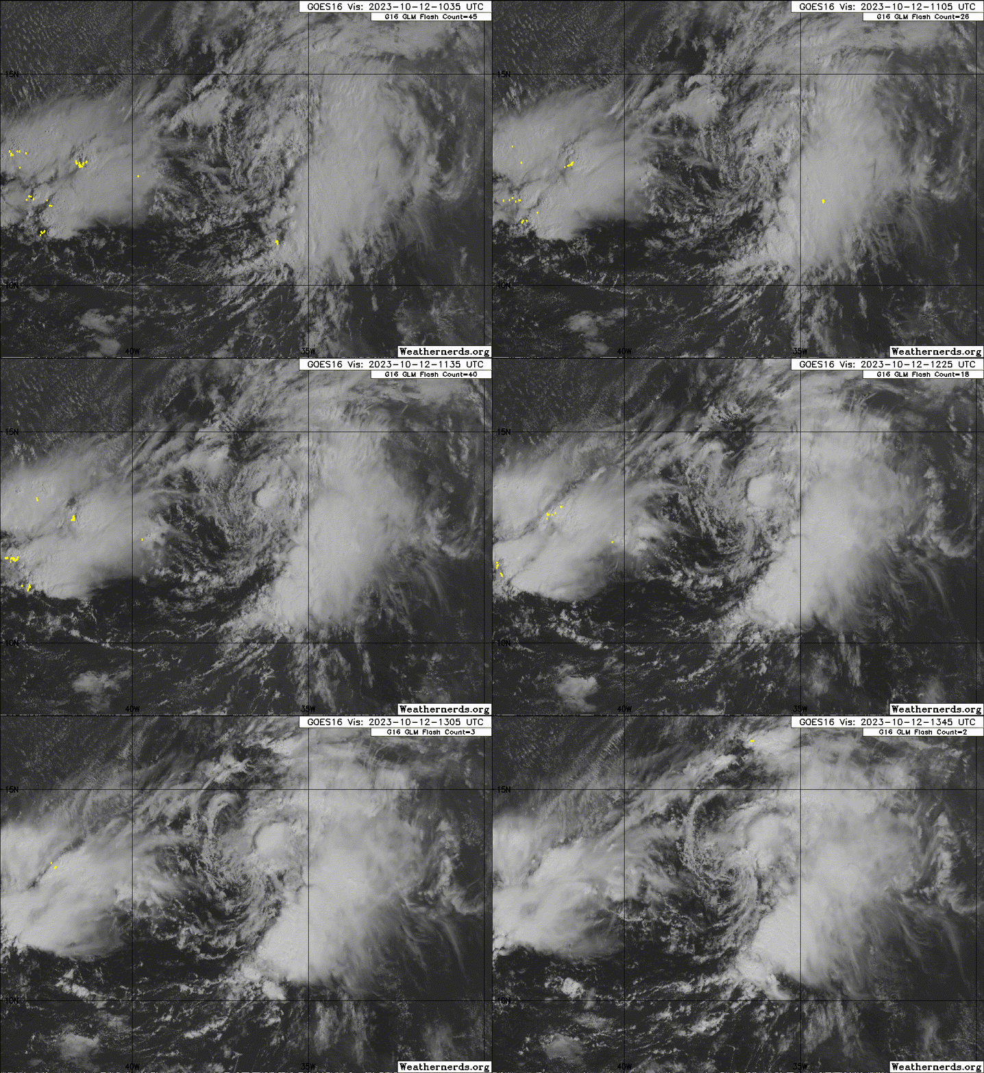
Image
0 likes   

User avatar
cycloneye
Admin
Admin
Posts: 139087
Age: 67
Joined: Thu Oct 10, 2002 10:54 am
Location: San Juan, Puerto Rico

Re: ATL: SEAN - Tropical Storm - Discussion

#80 Postby cycloneye » Thu Oct 12, 2023 9:54 am

BULLETIN
Tropical Storm Sean Advisory Number 7
NWS National Hurricane Center Miami FL AL192023
1100 AM AST Thu Oct 12 2023

...SEAN STRENGTHENS BACK INTO A TROPICAL STORM...
0 likes   
Visit the Caribbean-Central America Weather Thread where you can find at first post web cams,radars
and observations from Caribbean basin members Click Here


Return to “2023”

Who is online

Users browsing this forum: No registered users and 78 guests