
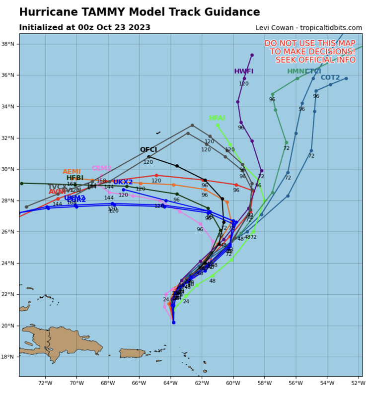
0Z UKMET has a mainly westbound to WNW moving Tammy hours 120-168:
HURRICANE TAMMY ANALYSED POSITION : 17.5N 61.5W
ATCF IDENTIFIER : AL202023
LEAD CENTRAL MAXIMUM WIND
VERIFYING TIME TIME POSITION PRESSURE (MB) SPEED (KNOTS)
-------------- ---- -------- ------------- -------------
0000UTC 22.10.2023 0 17.5N 61.5W 999 48
1200UTC 22.10.2023 12 18.7N 62.4W 1003 45
0000UTC 23.10.2023 24 19.8N 63.5W 1003 41
1200UTC 23.10.2023 36 20.8N 63.7W 1004 39
0000UTC 24.10.2023 48 21.7N 63.8W 1004 36
1200UTC 24.10.2023 60 22.1N 63.5W 1004 37
0000UTC 25.10.2023 72 21.2N 64.2W 1004 29
1200UTC 25.10.2023 84 21.4N 63.3W 1003 30
0000UTC 26.10.2023 96 21.7N 62.2W 1001 31
1200UTC 26.10.2023 108 23.5N 61.7W 999 37
0000UTC 27.10.2023 120 24.9N 61.7W 999 41
1200UTC 27.10.2023 132 25.9N 63.7W 999 39
0000UTC 28.10.2023 144 26.6N 66.8W 998 40
1200UTC 28.10.2023 156 26.2N 69.4W 997 36
0000UTC 29.10.2023 168 26.4N 71.2W 1000 37
ATL: TAMMY - Models
Moderator: S2k Moderators
Re: ATL: TAMMY - Models
2 likes
Personal Forecast Disclaimer:
The posts in this forum are NOT official forecasts and should not be used as such. They are just the opinion of the poster and may or may not be backed by sound meteorological data. They are NOT endorsed by any professional institution or storm2k.org. For official information, please refer to the NHC and NWS products.
The posts in this forum are NOT official forecasts and should not be used as such. They are just the opinion of the poster and may or may not be backed by sound meteorological data. They are NOT endorsed by any professional institution or storm2k.org. For official information, please refer to the NHC and NWS products.
-
jconsor
- Professional-Met

- Posts: 532
- Joined: Mon Jun 30, 2008 9:31 pm
- Location: Jerusalem, Israel
- Contact:
Re: ATL: TAMMY - Models
UKMET should be taken with a large grain of salt IMHO, given that it is initializing Tammy too weak and has a strong ridge bias. Seems to me highly unlikely Tammy will still be so close to 20N between 48 and 96 hours.
Interesting to note that today's UKMET run is stronger than yesterday's 0z run Tue into late next week. Also seems more realistic than yesterday's run by showing a NE and then N motion before the hard left turn to the W/WNW.
HURRICANE TAMMY ANALYSED POSITION : 14.7N 59.6W
ATCF IDENTIFIER : AL202023
LEAD CENTRAL MAXIMUM WIND
VERIFYING TIME TIME POSITION PRESSURE (MB) SPEED (KNOTS)
-------------- ---- -------- ------------- -------------
0000UTC 21.10.2023 0 14.7N 59.6W 1000 54
1200UTC 21.10.2023 12 16.0N 60.7W 1000 53
0000UTC 22.10.2023 24 17.2N 62.1W 1004 38
1200UTC 22.10.2023 36 18.5N 62.8W 1005 39
0000UTC 23.10.2023 48 19.5N 63.8W 1005 35
1200UTC 23.10.2023 60 20.6N 64.0W 1005 37
0000UTC 24.10.2023 72 21.1N 64.2W 1004 35
1200UTC 24.10.2023 84 21.4N 64.4W 1003 35
0000UTC 25.10.2023 96 21.1N 64.5W 1003 28
1200UTC 25.10.2023 108 20.9N 64.9W 1002 28
0000UTC 26.10.2023 120 20.8N 64.9W 1002 28
1200UTC 26.10.2023 132 21.7N 64.7W 1002 27
0000UTC 27.10.2023 144 23.2N 64.2W 1002 29
1200UTC 27.10.2023 156 24.7N 64.4W 1003 29
0000UTC 28.10.2023 168 26.3N 64.7W 1005 29
What I also find interesting is that the UKMET like most guidance is trending toward a stronger ridge N/NW of Tammy and a stronger upper low cutting off SW of her. So the hard left turn makes sense given this setup.
LarryWx wrote:0Z UKMET has a mainly westbound to WNW moving Tammy hours 120-168:
HURRICANE TAMMY ANALYSED POSITION : 17.5N 61.5W
ATCF IDENTIFIER : AL202023
LEAD CENTRAL MAXIMUM WIND
VERIFYING TIME TIME POSITION PRESSURE (MB) SPEED (KNOTS)
-------------- ---- -------- ------------- -------------
0000UTC 22.10.2023 0 17.5N 61.5W 999 48
1200UTC 22.10.2023 12 18.7N 62.4W 1003 45
0000UTC 23.10.2023 24 19.8N 63.5W 1003 41
1200UTC 23.10.2023 36 20.8N 63.7W 1004 39
0000UTC 24.10.2023 48 21.7N 63.8W 1004 36
1200UTC 24.10.2023 60 22.1N 63.5W 1004 37
0000UTC 25.10.2023 72 21.2N 64.2W 1004 29
1200UTC 25.10.2023 84 21.4N 63.3W 1003 30
0000UTC 26.10.2023 96 21.7N 62.2W 1001 31
1200UTC 26.10.2023 108 23.5N 61.7W 999 37
0000UTC 27.10.2023 120 24.9N 61.7W 999 41
1200UTC 27.10.2023 132 25.9N 63.7W 999 39
0000UTC 28.10.2023 144 26.6N 66.8W 998 40
1200UTC 28.10.2023 156 26.2N 69.4W 997 36
0000UTC 29.10.2023 168 26.4N 71.2W 1000 37
1 likes
Re: ATL: TAMMY - Models
12Z UKMET: similar to 0Z run with a W heading 108-168 at ~10 mph slightly N of 0Z run:
HURRICANE TAMMY ANALYSED POSITION : 18.9N 62.6W
ATCF IDENTIFIER : AL202023
LEAD CENTRAL MAXIMUM WIND
VERIFYING TIME TIME POSITION PRESSURE (MB) SPEED (KNOTS)
-------------- ---- -------- ------------- -------------
1200UTC 22.10.2023 0 18.9N 62.6W 998 50
0000UTC 23.10.2023 12 20.2N 63.8W 1000 38
1200UTC 23.10.2023 24 21.4N 63.7W 1001 42
0000UTC 24.10.2023 36 22.2N 63.3W 1000 42
1200UTC 24.10.2023 48 22.6N 62.9W 1001 38
0000UTC 25.10.2023 60 22.8N 62.6W 1001 30
1200UTC 25.10.2023 72 23.7N 61.4W 999 36
0000UTC 26.10.2023 84 25.0N 59.7W 996 54
1200UTC 26.10.2023 96 26.7N 59.1W 995 49
0000UTC 27.10.2023 108 27.2N 61.0W 997 43
1200UTC 27.10.2023 120 27.7N 64.0W 998 45
0000UTC 28.10.2023 132 27.7N 67.7W 995 39
1200UTC 28.10.2023 144 27.5N 69.8W 997 36
0000UTC 29.10.2023 156 27.6N 71.5W 1000 37
1200UTC 29.10.2023 168 27.2N 73.4W 1003 33
0 likes
Personal Forecast Disclaimer:
The posts in this forum are NOT official forecasts and should not be used as such. They are just the opinion of the poster and may or may not be backed by sound meteorological data. They are NOT endorsed by any professional institution or storm2k.org. For official information, please refer to the NHC and NWS products.
The posts in this forum are NOT official forecasts and should not be used as such. They are just the opinion of the poster and may or may not be backed by sound meteorological data. They are NOT endorsed by any professional institution or storm2k.org. For official information, please refer to the NHC and NWS products.

Re: ATL: TAMMY - Models
LarryWx wrote:12Z UKMET: similar to 0Z run with a W heading 108-168 at ~10 mph slightly N of 0Z run:
HURRICANE TAMMY ANALYSED POSITION : 18.9N 62.6W
ATCF IDENTIFIER : AL202023
LEAD CENTRAL MAXIMUM WIND
VERIFYING TIME TIME POSITION PRESSURE (MB) SPEED (KNOTS)
-------------- ---- -------- ------------- -------------
1200UTC 22.10.2023 0 18.9N 62.6W 998 50
0000UTC 23.10.2023 12 20.2N 63.8W 1000 38
1200UTC 23.10.2023 24 21.4N 63.7W 1001 42
0000UTC 24.10.2023 36 22.2N 63.3W 1000 42
1200UTC 24.10.2023 48 22.6N 62.9W 1001 38
0000UTC 25.10.2023 60 22.8N 62.6W 1001 30
1200UTC 25.10.2023 72 23.7N 61.4W 999 36
0000UTC 26.10.2023 84 25.0N 59.7W 996 54
1200UTC 26.10.2023 96 26.7N 59.1W 995 49
0000UTC 27.10.2023 108 27.2N 61.0W 997 43
1200UTC 27.10.2023 120 27.7N 64.0W 998 45
0000UTC 28.10.2023 132 27.7N 67.7W 995 39
1200UTC 28.10.2023 144 27.5N 69.8W 997 36
0000UTC 29.10.2023 156 27.6N 71.5W 1000 37
1200UTC 29.10.2023 168 27.2N 73.4W 1003 33
So if the front doesn't dig and either shear Tammy to an open wave or take it out to sea by Thursday its going to be under a massive ridge drifting west? So why is the UKMET forecasting rising surface pressure after the front?
0 likes

Re: ATL: TAMMY - Models
A lot more Ensembles coming west faster.

1 likes
The following post is NOT an official forecast and should not be used as such. It is just the opinion of the poster and may or may not be backed by sound meteorological data. It is NOT endorsed by any professional institution including storm2k.org For Official Information please refer to the NHC and NWS products.
-
Blown Away

- S2K Supporter

- Posts: 9861
- Joined: Wed May 26, 2004 6:17 am
Re: ATL: TAMMY - Models
00z early big W trend.
0 likes
Hurricane Eye Experience: David 79, Irene 99, Frances 04, Jeanne 04, Wilma 05...
Hurricane Brush Experience: Andrew 92, Erin 95, Floyd 99, Matthew 16, Irma 17, Ian 22, Nicole 22…
Hurricane Brush Experience: Andrew 92, Erin 95, Floyd 99, Matthew 16, Irma 17, Ian 22, Nicole 22…
-
jlauderdal
- S2K Supporter
- Posts: 6771
- Joined: Wed May 19, 2004 5:46 am
- Location: NE Fort Lauderdale
- Contact:
Re: ATL: TAMMY - Models
0Z GFS/CMC: keep it well OTS from Bahamas/CONUS
0Z ICON: after initially going NE turns west and goes into S FL at 180 as a weakening low
0Z UKMET: similarly to at least last two runs it first goes NNE and later turns WSW at 10 mph making it to 150 miles E of the N Bahamas while then weakening:
HURRICANE TAMMY ANALYSED POSITION : 20.3N 63.8W
ATCF IDENTIFIER : AL202023
LEAD CENTRAL MAXIMUM WIND
VERIFYING TIME TIME POSITION PRESSURE (MB) SPEED (KNOTS)
-------------- ---- -------- ------------- -------------
0000UTC 23.10.2023 0 20.3N 63.8W 999 47
1200UTC 23.10.2023 12 21.7N 64.5W 1001 37
0000UTC 24.10.2023 24 22.3N 63.5W 999 39
1200UTC 24.10.2023 36 22.9N 62.8W 998 37
0000UTC 25.10.2023 48 23.5N 61.6W 997 36
1200UTC 25.10.2023 60 24.9N 60.0W 993 43
0000UTC 26.10.2023 72 26.7N 58.6W 988 57
1200UTC 26.10.2023 84 28.9N 58.1W 992 44
0000UTC 27.10.2023 96 29.8N 59.5W 997 48
1200UTC 27.10.2023 108 29.9N 62.1W 1000 41
0000UTC 28.10.2023 120 30.0N 65.8W 998 46
1200UTC 28.10.2023 132 30.3N 67.9W 1001 36
0000UTC 29.10.2023 144 29.5N 70.3W 1001 34
1200UTC 29.10.2023 156 28.0N 72.6W 1003 31
0000UTC 30.10.2023 168 27.2N 74.7W 1006 30
0 likes
Personal Forecast Disclaimer:
The posts in this forum are NOT official forecasts and should not be used as such. They are just the opinion of the poster and may or may not be backed by sound meteorological data. They are NOT endorsed by any professional institution or storm2k.org. For official information, please refer to the NHC and NWS products.
The posts in this forum are NOT official forecasts and should not be used as such. They are just the opinion of the poster and may or may not be backed by sound meteorological data. They are NOT endorsed by any professional institution or storm2k.org. For official information, please refer to the NHC and NWS products.
-
ThunderForce

- Tropical Storm

- Posts: 158
- Age: 25
- Joined: Tue Sep 27, 2022 6:20 pm
- Location: Florida Panhandle
Re: ATL: TAMMY - Models
06z came in and the tracks are generally all over the place.
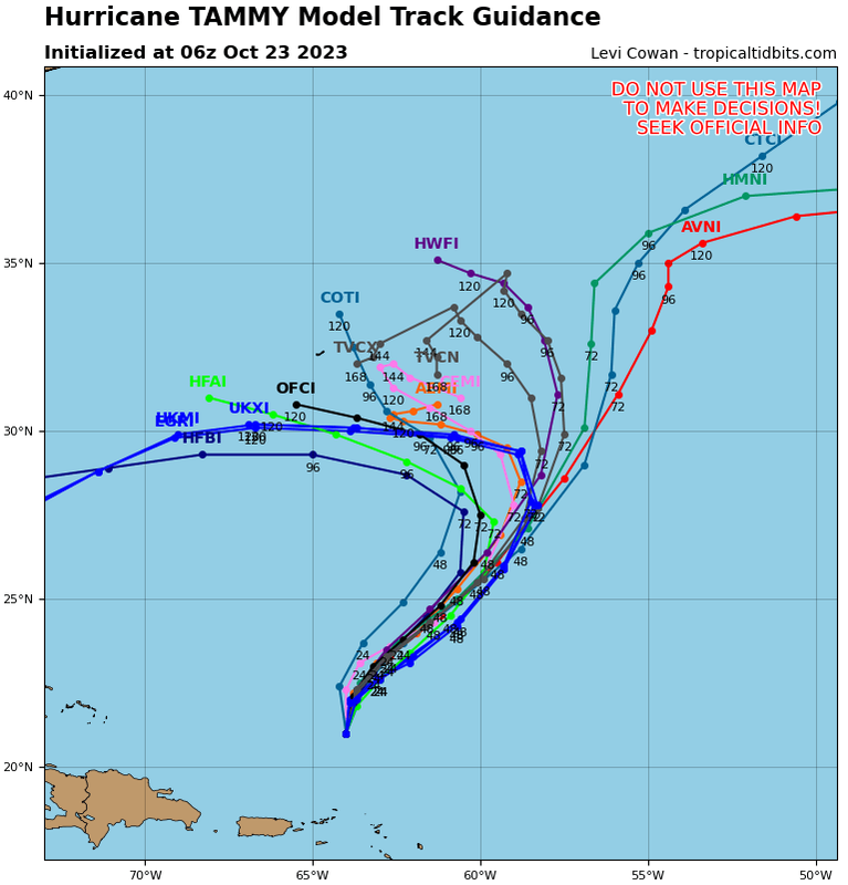
AVNI, HMNI and CTCI want to have Tammy safely recurve out to sea.
HFAI, HFBI, UKXI, HKMI and EGRI want Tammy to sharply turn westward.
HWFI, COTI, AEMI and CEMI are in the middle. Not quite recurving but not making a sharp left turn either.
The TVCN has actually moved a bit more northeastward compared to 00z though, for some reason.
As for the 06z intensity forecasts:
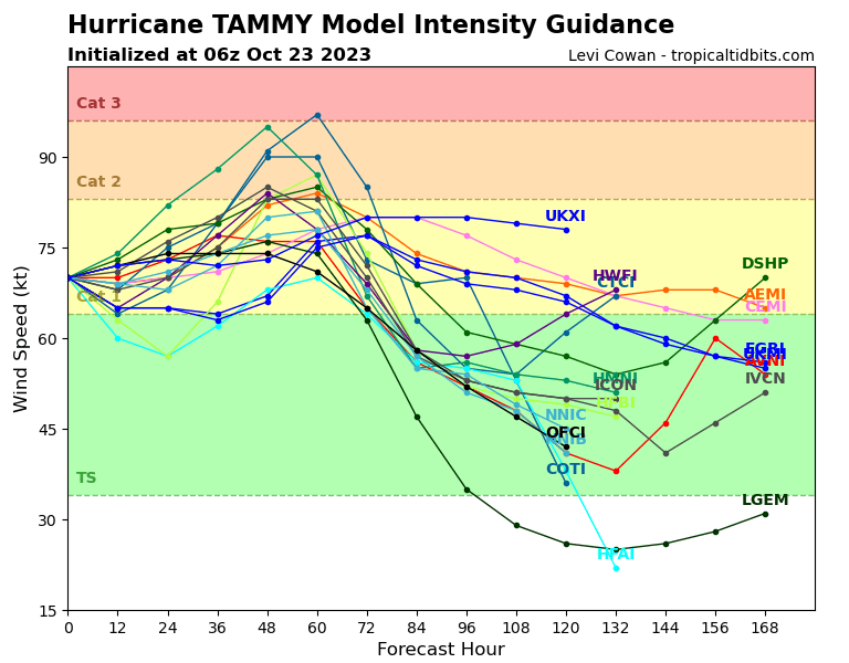
Well, they're pretty different from the 00z. DSHP (which the NHC has been mostly looking to for forecasting Tammy's intensity over time) has changed from having the storm weakening over time into a tropical storm and staying one up to the 168 mark, to featuring Tammy restrengthening into a Category 1 again after a little while as a tropical storm. As for the others...
HWFI, CTCI, AEMI, and UKXI all feature Tammy being a Category 1 at the end of their forecast periods.
HMNI and CTCI additionally feature Tammy strengthening into a Category 2 at some point before weakening, with the latter additionally featuring a brief Category 3 peak.
The rest have Tammy weakening into a tropical storm up until the end of their forecast periods, with HFAI and LGEM additionally featuring Tammy weakening into a tropical depression. IVCN, AVNI and LGEM feature Tammy restrengthening during their periods though.
AVNI, HMNI and CTCI want to have Tammy safely recurve out to sea.
HFAI, HFBI, UKXI, HKMI and EGRI want Tammy to sharply turn westward.
HWFI, COTI, AEMI and CEMI are in the middle. Not quite recurving but not making a sharp left turn either.
The TVCN has actually moved a bit more northeastward compared to 00z though, for some reason.
As for the 06z intensity forecasts:
Well, they're pretty different from the 00z. DSHP (which the NHC has been mostly looking to for forecasting Tammy's intensity over time) has changed from having the storm weakening over time into a tropical storm and staying one up to the 168 mark, to featuring Tammy restrengthening into a Category 1 again after a little while as a tropical storm. As for the others...
HWFI, CTCI, AEMI, and UKXI all feature Tammy being a Category 1 at the end of their forecast periods.
HMNI and CTCI additionally feature Tammy strengthening into a Category 2 at some point before weakening, with the latter additionally featuring a brief Category 3 peak.
The rest have Tammy weakening into a tropical storm up until the end of their forecast periods, with HFAI and LGEM additionally featuring Tammy weakening into a tropical depression. IVCN, AVNI and LGEM feature Tammy restrengthening during their periods though.
1 likes
Please refer to the NWS, NHC, SPC or a professional meteorologist for information and decision making during storms.
Re: ATL: TAMMY - Models
12Z UKMET changes its mind and doesn’t bring Tammy back W like prior 3+ runs:
HURRICANE TAMMY ANALYSED POSITION : 21.4N 64.2W
ATCF IDENTIFIER : AL202023
LEAD CENTRAL MAXIMUM WIND
VERIFYING TIME TIME POSITION PRESSURE (MB) SPEED (KNOTS)
-------------- ---- -------- ------------- -------------
1200UTC 23.10.2023 0 21.4N 64.2W 1004 37
0000UTC 24.10.2023 12 22.3N 63.7W 1002 42
1200UTC 24.10.2023 24 23.0N 62.8W 1001 38
0000UTC 25.10.2023 36 23.7N 61.5W 998 41
1200UTC 25.10.2023 48 24.6N 60.3W 997 42
0000UTC 26.10.2023 60 26.9N 58.1W 993 53
1200UTC 26.10.2023 72 29.5N 57.9W 993 47
0000UTC 27.10.2023 84 30.3N 59.1W 993 46
1200UTC 27.10.2023 96 31.1N 61.0W 996 43
0000UTC 28.10.2023 108 31.9N 62.9W 995 43
1200UTC 28.10.2023 120 33.0N 63.3W 998 35
0000UTC 29.10.2023 132 33.6N 62.4W 995 36
1200UTC 29.10.2023 144 34.2N 60.4W 998 38
0000UTC 30.10.2023 156 33.9N 58.6W 1002 32
1200UTC 30.10.2023 168 33.3N 56.9W 1006 29
————————————-
Edit:
0Z UKMET similarly keeps it well OTS:
HURRICANE TAMMY ANALYSED POSITION : 22.8N 63.5W
ATCF IDENTIFIER : AL202023
LEAD CENTRAL MAXIMUM WIND
VERIFYING TIME TIME POSITION PRESSURE (MB) SPEED (KNOTS)
-------------- ---- -------- ------------- -------------
0000UTC 24.10.2023 0 22.8N 63.5W 998 46
1200UTC 24.10.2023 12 23.4N 62.6W 996 43
0000UTC 25.10.2023 24 24.4N 61.2W 992 43
1200UTC 25.10.2023 36 25.8N 59.5W 989 51
0000UTC 26.10.2023 48 28.2N 57.9W 985 51
1200UTC 26.10.2023 60 30.3N 58.5W 986 50
0000UTC 27.10.2023 72 30.9N 59.8W 987 53
1200UTC 27.10.2023 84 31.3N 61.4W 988 45
0000UTC 28.10.2023 96 31.7N 62.6W 989 43
1200UTC 28.10.2023 108 32.8N 62.3W 987 50
0000UTC 29.10.2023 120 34.5N 60.3W 989 45
1200UTC 29.10.2023 132 35.3N 56.4W 987 48
0000UTC 30.10.2023 144 34.5N 50.6W 987 52
1200UTC 30.10.2023 156 32.5N 45.3W 988 48
0000UTC 31.10.2023 168 28.7N 43.4W 992 44
0 likes
Personal Forecast Disclaimer:
The posts in this forum are NOT official forecasts and should not be used as such. They are just the opinion of the poster and may or may not be backed by sound meteorological data. They are NOT endorsed by any professional institution or storm2k.org. For official information, please refer to the NHC and NWS products.
The posts in this forum are NOT official forecasts and should not be used as such. They are just the opinion of the poster and may or may not be backed by sound meteorological data. They are NOT endorsed by any professional institution or storm2k.org. For official information, please refer to the NHC and NWS products.
-
MEANINGLESS_NUMBERS
- Tropical Depression

- Posts: 58
- Joined: Mon Nov 02, 2020 1:43 pm
Re: ATL: TAMMY - Models

At 120 hours the guidance suggests that Tammy will be somewhere between GOM and Iceland.
13 likes
Re: ATL: TAMMY - Models
18Z ICON at 120 hrs N Bahamas 998 mb TS moving W at ~15 mph
0 likes
Personal Forecast Disclaimer:
The posts in this forum are NOT official forecasts and should not be used as such. They are just the opinion of the poster and may or may not be backed by sound meteorological data. They are NOT endorsed by any professional institution or storm2k.org. For official information, please refer to the NHC and NWS products.
The posts in this forum are NOT official forecasts and should not be used as such. They are just the opinion of the poster and may or may not be backed by sound meteorological data. They are NOT endorsed by any professional institution or storm2k.org. For official information, please refer to the NHC and NWS products.
Re: ATL: TAMMY - Models
18 GEFS more members over Florida.

0 likes
The following post is NOT an official forecast and should not be used as such. It is just the opinion of the poster and may or may not be backed by sound meteorological data. It is NOT endorsed by any professional institution including storm2k.org For Official Information please refer to the NHC and NWS products.

Re: ATL: TAMMY - Models
Teban54 wrote:
Those ensemble members look like fireworks.
Your right, crazy spread.
0 likes
The following post is NOT an official forecast and should not be used as such. It is just the opinion of the poster and may or may not be backed by sound meteorological data. It is NOT endorsed by any professional institution including storm2k.org For Official Information please refer to the NHC and NWS products.
Re: ATL: TAMMY - Models
0Z ICON just like 18Z ICON heads to S FL Sun night. That would be going against almost all of the W basin headings of the entire season. But the 0Z UKMET, GFS, and CMC all stay way out.
0 likes
Personal Forecast Disclaimer:
The posts in this forum are NOT official forecasts and should not be used as such. They are just the opinion of the poster and may or may not be backed by sound meteorological data. They are NOT endorsed by any professional institution or storm2k.org. For official information, please refer to the NHC and NWS products.
The posts in this forum are NOT official forecasts and should not be used as such. They are just the opinion of the poster and may or may not be backed by sound meteorological data. They are NOT endorsed by any professional institution or storm2k.org. For official information, please refer to the NHC and NWS products.
-
cycloneye

- Admin

- Posts: 139083
- Age: 67
- Joined: Thu Oct 10, 2002 10:54 am
- Location: San Juan, Puerto Rico
Re: ATL: TAMMY - Models
0 likes
Visit the Caribbean-Central America Weather Thread where you can find at first post web cams,radars
and observations from Caribbean basin members Click Here
and observations from Caribbean basin members Click Here
-
cycloneye
- Admin
- Posts: 139083
- Age: 67
- Joined: Thu Oct 10, 2002 10:54 am
- Location: San Juan, Puerto Rico
Re: ATL: TAMMY - Models
European in a circle. 

6 likes
Visit the Caribbean-Central America Weather Thread where you can find at first post web cams,radars
and observations from Caribbean basin members Click Here
and observations from Caribbean basin members Click Here
Re: ATL: TAMMY - Models
All of the sudden while the other models stay OTS, the 18Z GFS comes back pretty far west though not all the way as do some of the 18Z GEFS members.
0 likes
Personal Forecast Disclaimer:
The posts in this forum are NOT official forecasts and should not be used as such. They are just the opinion of the poster and may or may not be backed by sound meteorological data. They are NOT endorsed by any professional institution or storm2k.org. For official information, please refer to the NHC and NWS products.
The posts in this forum are NOT official forecasts and should not be used as such. They are just the opinion of the poster and may or may not be backed by sound meteorological data. They are NOT endorsed by any professional institution or storm2k.org. For official information, please refer to the NHC and NWS products.


Who is online
Users browsing this forum: No registered users and 78 guests