ATL: TAMMY - Models

Moderator: S2k Moderators

Message
Author
Ianswfl
Category 1
Category 1
Posts: 482
Joined: Thu Mar 23, 2023 11:11 pm

Re: ATL: INVEST 94L - Models

#81 Postby Ianswfl » Mon Oct 16, 2023 10:15 pm

Blown Away wrote:
Blown Away wrote:
Ianswfl wrote:Euro ensembles mega shift west. Couple models look interesting for us in Florida


[url]https://i.postimg.cc/pr220f9J/eps-lowlocs-watl-fh66-312.gif [/url]


I’d say pretty low confidence, Nicole was extremely rare Nov track and to have it 2 years in a row seems very unlikely.


Plus battling drier nov air too! Had Nicole happened in sept or even mid oct she would have been retired and a very nasty storm. Probably a rare cat4 in that area. Would have had more favorable water temps, humidity during peak of season.
1 likes   

WeatherBoy2000
Tropical Depression
Tropical Depression
Posts: 88
Joined: Mon Apr 10, 2023 9:29 am

Re: ATL: INVEST 94L - Models

#82 Postby WeatherBoy2000 » Mon Oct 16, 2023 11:51 pm

The gfs, cmc, hwrf, hmon, hafs-a still have this becoming a hurricane at some point. The icon still has a weak tc. Only the euro and hafs-b have no development. Although still a mess, 94l's been getting more convectively active again. It seems like a wild card whether this becomes a hurricane, but development of some sort is more likely than not imo.
1 likes   

User avatar
cycloneye
Admin
Admin
Posts: 139082
Age: 67
Joined: Thu Oct 10, 2002 10:54 am
Location: San Juan, Puerto Rico

Re: ATL: INVEST 94L - Models

#83 Postby cycloneye » Tue Oct 17, 2023 8:48 am

The hurricane models are a little bit closer to the islands and some move over.

Image

Intensity is up on some of them.

Image
1 likes   
Visit the Caribbean-Central America Weather Thread where you can find at first post web cams,radars
and observations from Caribbean basin members Click Here

User avatar
cycloneye
Admin
Admin
Posts: 139082
Age: 67
Joined: Thu Oct 10, 2002 10:54 am
Location: San Juan, Puerto Rico

Re: ATL: INVEST 94L - Models

#84 Postby cycloneye » Tue Oct 17, 2023 9:52 am

0 likes   
Visit the Caribbean-Central America Weather Thread where you can find at first post web cams,radars
and observations from Caribbean basin members Click Here

User avatar
abajan
S2K Supporter
S2K Supporter
Posts: 4175
Joined: Sun Sep 07, 2003 5:10 am
Location: Barbados

Re: ATL: INVEST 94L - Models

#85 Postby abajan » Tue Oct 17, 2023 10:54 am

cycloneye wrote:The hurricane models are a little bit closer to the islands and some move over.

https://i.imgur.com/fS7v9eU.png

Intensity is up on some of them.

https://i.imgur.com/6CO647J.png

I would be very surprised if 94L becomes a strong tropical storm, far less a hurricane, in just 3 days' time. But we'll see.
0 likes   

LarryWx
Category 5
Category 5
Posts: 5700
Joined: Sun Sep 07, 2003 2:04 pm
Location: GA

Re: ATL: INVEST 94L - Models

#86 Postby LarryWx » Tue Oct 17, 2023 11:21 am

The 12Z UKMET text doesn’t show TCG with this fwiw, but it is sometimes too conservative. I wouldn’t be surprised if there is TCG.
1 likes   
Personal Forecast Disclaimer:
The posts in this forum are NOT official forecasts and should not be used as such. They are just the opinion of the poster and may or may not be backed by sound meteorological data. They are NOT endorsed by any professional institution or storm2k.org. For official information, please refer to the NHC and NWS products.

WeatherBoy2000
Tropical Depression
Tropical Depression
Posts: 88
Joined: Mon Apr 10, 2023 9:29 am

Re: ATL: INVEST 94L - Models

#87 Postby WeatherBoy2000 » Tue Oct 17, 2023 11:28 am

The GFS is still insistent that this thing is about to take off, we'll find out very soon if it has any merit. We should see an area of organized deep convection by late evening/tomorrow morning as shown on the simulated IR satellite. I think it's being overly bullish, like how it was with Philippe at one point.
4 likes   

User avatar
abajan
S2K Supporter
S2K Supporter
Posts: 4175
Joined: Sun Sep 07, 2003 5:10 am
Location: Barbados

Re: ATL: INVEST 94L - Models

#88 Postby abajan » Wed Oct 18, 2023 2:19 am

0z Euro is a bit more W than WNW into the Leeward Islands, and a bit stronger too.

Image
0 likes   

User avatar
AubreyStorm
Category 1
Category 1
Posts: 322
Age: 43
Joined: Fri Jun 16, 2017 6:21 pm
Location: Texas, USA

Re: ATL: INVEST 94L - Models

#89 Postby AubreyStorm » Wed Oct 18, 2023 6:37 am

It’s quiet here!

Invest 94L


Image
2 likes   
The posts are NOT an official forecast. Please REFER to the NHC and NWS for official forecasts and products.

tolakram
Admin
Admin
Posts: 19165
Age: 60
Joined: Sun Aug 27, 2006 8:23 pm
Location: Florence, KY (name is Mark)

Re: ATL: INVEST 94L - Models

#90 Postby tolakram » Wed Oct 18, 2023 10:11 am

Look like Euro is back onboard some development again, and GFS is not only sticking to development but a little stronger. Cat 1 maybe is my best guess, after the islands, BUT it sure looks like this will be an event for the northern Leewards.
1 likes   
M a r k
- - - - -
Join us in chat: Storm2K Chatroom Invite. Android and IOS apps also available.

The posts in this forum are NOT official forecasts and should not be used as such. Posts are NOT endorsed by any professional institution or STORM2K.org. For official information and forecasts, please refer to NHC and NWS products.

WeatherBoy2000
Tropical Depression
Tropical Depression
Posts: 88
Joined: Mon Apr 10, 2023 9:29 am

Re: ATL: INVEST 94L - Models

#91 Postby WeatherBoy2000 » Wed Oct 18, 2023 11:06 am

Looks like the gfs has finally caved towards a more realistic solution for at least the next two days.
0 likes   

floridasun
Tropical Storm
Tropical Storm
Posts: 107
Joined: Tue Sep 14, 2021 3:59 pm

Re: ATL: INVEST 94L - Models

#92 Postby floridasun » Wed Oct 18, 2023 11:28 am

Got feeling after affect leedislands going north and north east and near or east of Bermuda
0 likes   

LarryWx
Category 5
Category 5
Posts: 5700
Joined: Sun Sep 07, 2003 2:04 pm
Location: GA

Re: ATL: INVEST 94L - Models

#93 Postby LarryWx » Wed Oct 18, 2023 11:42 am

Once again, the latest UKMET doesn’t have TCG fwiw.
0 likes   
Personal Forecast Disclaimer:
The posts in this forum are NOT official forecasts and should not be used as such. They are just the opinion of the poster and may or may not be backed by sound meteorological data. They are NOT endorsed by any professional institution or storm2k.org. For official information, please refer to the NHC and NWS products.

User avatar
cycloneye
Admin
Admin
Posts: 139082
Age: 67
Joined: Thu Oct 10, 2002 10:54 am
Location: San Juan, Puerto Rico

Re: ATL: INVEST 94L - Models

#94 Postby cycloneye » Wed Oct 18, 2023 2:22 pm

Image

Image
0 likes   
Visit the Caribbean-Central America Weather Thread where you can find at first post web cams,radars
and observations from Caribbean basin members Click Here

User avatar
ThunderForce
Tropical Storm
Tropical Storm
Posts: 158
Age: 25
Joined: Tue Sep 27, 2022 6:20 pm
Location: Florida Panhandle

Re: ATL: INVEST 94L - Models

#95 Postby ThunderForce » Wed Oct 18, 2023 3:18 pm

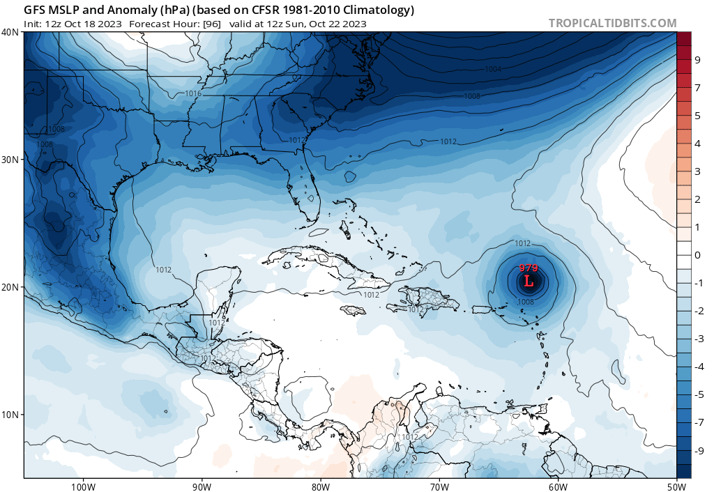
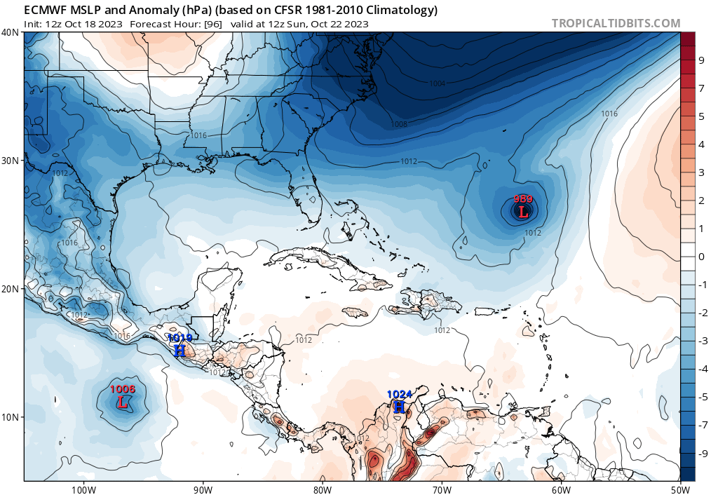
There seems to be a bit of a discrepancy between the GFS and Euro when it comes to Tammy's movement just 96 hours out. GFS is slower, but Euro is faster. Here's both models on 12z Sunday, October 22nd.

GFS 12z:
Image

Euro 12z:
Image
0 likes   
Please refer to the NWS, NHC, SPC or a professional meteorologist for information and decision making during storms.

tolakram
Admin
Admin
Posts: 19165
Age: 60
Joined: Sun Aug 27, 2006 8:23 pm
Location: Florence, KY (name is Mark)

Re: ATL: TAMMY - Models

#96 Postby tolakram » Wed Oct 18, 2023 5:19 pm

1 likes   
M a r k
- - - - -
Join us in chat: Storm2K Chatroom Invite. Android and IOS apps also available.

The posts in this forum are NOT official forecasts and should not be used as such. Posts are NOT endorsed by any professional institution or STORM2K.org. For official information and forecasts, please refer to NHC and NWS products.

User avatar
cycloneye
Admin
Admin
Posts: 139082
Age: 67
Joined: Thu Oct 10, 2002 10:54 am
Location: San Juan, Puerto Rico

Re: ATL: TAMMY - Models

#97 Postby cycloneye » Wed Oct 18, 2023 8:11 pm

Image

Image
0 likes   
Visit the Caribbean-Central America Weather Thread where you can find at first post web cams,radars
and observations from Caribbean basin members Click Here

LarryWx
Category 5
Category 5
Posts: 5700
Joined: Sun Sep 07, 2003 2:04 pm
Location: GA

Re: ATL: TAMMY - Models

#98 Postby LarryWx » Thu Oct 19, 2023 3:34 am

0Z UKMET
ROPICAL STORM TAMMY ANALYSED POSITION : 13.7N 52.8W

ATCF IDENTIFIER : AL202023

LEAD CENTRAL MAXIMUM WIND
VERIFYING TIME TIME POSITION PRESSURE (MB) SPEED (KNOTS)
-------------- ---- -------- ------------- -------------
0000UTC 19.10.2023 0 13.7N 52.8W 1008 36
1200UTC 19.10.2023 12 13.9N 56.0W 1009 32
0000UTC 20.10.2023 24 14.3N 57.4W 1008 30
1200UTC 20.10.2023 36 15.0N 60.3W 1009 32
0000UTC 21.10.2023 48 CEASED TRACKING
1 likes   
Personal Forecast Disclaimer:
The posts in this forum are NOT official forecasts and should not be used as such. They are just the opinion of the poster and may or may not be backed by sound meteorological data. They are NOT endorsed by any professional institution or storm2k.org. For official information, please refer to the NHC and NWS products.

IsabelaWeather
Tropical Storm
Tropical Storm
Posts: 217
Age: 34
Joined: Tue Jul 07, 2020 7:29 am
Location: Isabela, Puerto Rico

Re: ATL: TAMMY - Models

#99 Postby IsabelaWeather » Thu Oct 19, 2023 4:35 am

LarryWx wrote:
0Z UKMET
ROPICAL STORM TAMMY ANALYSED POSITION : 13.7N 52.8W

ATCF IDENTIFIER : AL202023

LEAD CENTRAL MAXIMUM WIND
VERIFYING TIME TIME POSITION PRESSURE (MB) SPEED (KNOTS)
-------------- ---- -------- ------------- -------------
0000UTC 19.10.2023 0 13.7N 52.8W 1008 36
1200UTC 19.10.2023 12 13.9N 56.0W 1009 32
0000UTC 20.10.2023 24 14.3N 57.4W 1008 30
1200UTC 20.10.2023 36 15.0N 60.3W 1009 32
0000UTC 21.10.2023 48 CEASED TRACKING


Why has the UKMET not developed pretty much anything all season?
0 likes   

User avatar
Nimbus
Category 5
Category 5
Posts: 4928
Joined: Mon Jul 19, 2004 10:54 am

Re: ATL: TAMMY - Models

#100 Postby Nimbus » Thu Oct 19, 2023 7:34 am

IsabelaWeather wrote:
LarryWx wrote:
0Z UKMET
ROPICAL STORM TAMMY ANALYSED POSITION : 13.7N 52.8W

ATCF IDENTIFIER : AL202023

LEAD CENTRAL MAXIMUM WIND
VERIFYING TIME TIME POSITION PRESSURE (MB) SPEED (KNOTS)
-------------- ---- -------- ------------- -------------
0000UTC 19.10.2023 0 13.7N 52.8W 1008 36
1200UTC 19.10.2023 12 13.9N 56.0W 1009 32
0000UTC 20.10.2023 24 14.3N 57.4W 1008 30
1200UTC 20.10.2023 36 15.0N 60.3W 1009 32
0000UTC 21.10.2023 48 CEASED TRACKING


Why has the UKMET not developed pretty much anything all season?


06Z GFS already gear up missing Guadalupe as Tammy track passes to the NE?
0 likes   


Return to “2023”

Who is online

Users browsing this forum: No registered users and 73 guests