ATL: INVEST 97L - Models

Moderator: S2k Moderators

Message
Author
mantis83
Tropical Storm
Tropical Storm
Posts: 123
Joined: Fri Dec 05, 2003 4:47 pm

Re: ATL: INVEST 97L - Models

#21 Postby mantis83 » Tue Oct 31, 2023 3:43 pm

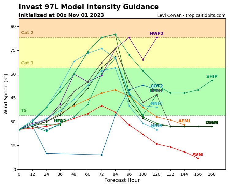
gatorcane wrote:Looks like the Euro may get this right after all. The GFS yet again is showing weak and into CA as the Euro has consistently shown from the beginning. The GFS needs a big upgrade during the off-season to address its issues particularly the convective feedback problems it has in the Caribbean.

agreed! all those earlier gfs runs of a big hurricane hitting south florida was never going to happen, follow the euro for accuracy folks! :D
0 likes   

DunedinDave
Tropical Low
Tropical Low
Posts: 11
Joined: Fri Aug 25, 2023 10:31 am

Re: ATL: INVEST 97L - Models

#22 Postby DunedinDave » Tue Oct 31, 2023 5:40 pm

As I said the GFS would either look like a million bucks or
Have egg on their face. Well Happy Halloween GFS. Hope the egg tastes good.
2 likes   

User avatar
cycloneye
Admin
Admin
Posts: 139081
Age: 67
Joined: Thu Oct 10, 2002 10:54 am
Location: San Juan, Puerto Rico

Re: ATL: INVEST 97L - Models

#23 Postby cycloneye » Tue Oct 31, 2023 8:46 pm

Solid consensus to Central America.

Image
0 likes   
Visit the Caribbean-Central America Weather Thread where you can find at first post web cams,radars
and observations from Caribbean basin members Click Here

AutoPenalti
Category 5
Category 5
Posts: 3949
Age: 27
Joined: Mon Aug 17, 2015 4:16 pm
Location: Ft. Lauderdale, Florida

Re: ATL: INVEST 97L - Models

#24 Postby AutoPenalti » Tue Oct 31, 2023 8:58 pm

GFS has huge issues it needs to resolve.
1 likes   
The posts in this forum are NOT official forecasts and should not be used as such. They are just the opinion of the poster and may or may not be backed by sound meteorological data. They are NOT endorsed by any professional institution or STORM2K. For official information, please refer to products from the NHC and NWS.


Model Runs Cheat Sheet:
GFS (5:30 AM/PM, 11:30 AM/PM)
HWRF, GFDL, UKMET, NAVGEM (6:30-8:00 AM/PM, 12:30-2:00 AM/PM)
ECMWF (1:45 AM/PM)

TCVN
is a weighted averaged

User avatar
Teban54
Category 5
Category 5
Posts: 1958
Joined: Sat May 19, 2018 1:19 pm

Re: ATL: INVEST 97L - Models

#25 Postby Teban54 » Tue Oct 31, 2023 11:32 pm

Image
0 likes   

User avatar
Miami Storm Tracker
Category 3
Category 3
Posts: 893
Age: 66
Joined: Sun Jun 13, 2010 10:12 pm
Location: Key Largo, Fla.
Contact:

Re: ATL: INVEST 97L - Models

#26 Postby Miami Storm Tracker » Tue Oct 31, 2023 11:55 pm

Evening all
I am just so very grateful that it's not going to be a mjor issue for anyone especially South Fla/ the Keys. Can we just please close the season already.
0 likes   

User avatar
ThunderForce
Tropical Storm
Tropical Storm
Posts: 158
Age: 25
Joined: Tue Sep 27, 2022 6:20 pm
Location: Florida Panhandle

Re: ATL: INVEST 97L - Models

#27 Postby ThunderForce » Wed Nov 01, 2023 2:08 am

Image
0 likes   
Please refer to the NWS, NHC, SPC or a professional meteorologist for information and decision making during storms.

tolakram
Admin
Admin
Posts: 19165
Age: 60
Joined: Sun Aug 27, 2006 8:23 pm
Location: Florence, KY (name is Mark)

Re: ATL: INVEST 97L - Models

#28 Postby tolakram » Wed Nov 01, 2023 8:54 am

You can see why they are lowing percentages. Ensembles still show some possible development, but nothing coherent until 60 hours or so.

Image

Image

Image
0 likes   
M a r k
- - - - -
Join us in chat: Storm2K Chatroom Invite. Android and IOS apps also available.

The posts in this forum are NOT official forecasts and should not be used as such. Posts are NOT endorsed by any professional institution or STORM2K.org. For official information and forecasts, please refer to NHC and NWS products.

ChrisH-UK
Category 1
Category 1
Posts: 423
Joined: Sat May 29, 2021 8:22 am

Re: ATL: INVEST 97L - Models

#29 Postby ChrisH-UK » Wed Nov 01, 2023 2:08 pm

I think the global models may not have a good lock on 97L yet for instance here is the GFS and ECMWF 200-800mb shear models. They have 97L in a pocket of low shear with upper level out flow from 97L this could help 97L to from and intensify especially with the 30c sea temps.

Image
Image
0 likes   

User avatar
aspen
Category 5
Category 5
Posts: 8057
Joined: Sat Oct 12, 2019 7:10 pm
Location: Connecticut, USA

Re: ATL: INVEST 97L - Models

#30 Postby aspen » Thu Nov 02, 2023 12:23 pm

Another W for the Euro this year. This time, instead of sniffing out development ahead of the GFS, it sniffed out a phantom.
1 likes   
Irene '11 Sandy '12 Hermine '16 5/15/2018 Derecho Fay '20 Isaias '20 Elsa '21 Henri '21 Ida '21

I am only a meteorology enthusiast who knows a decent amount about tropical cyclones. Look to the professional mets, the NHC, or your local weather office for the best information.


Return to “2023”

Who is online

Users browsing this forum: No registered users and 86 guests