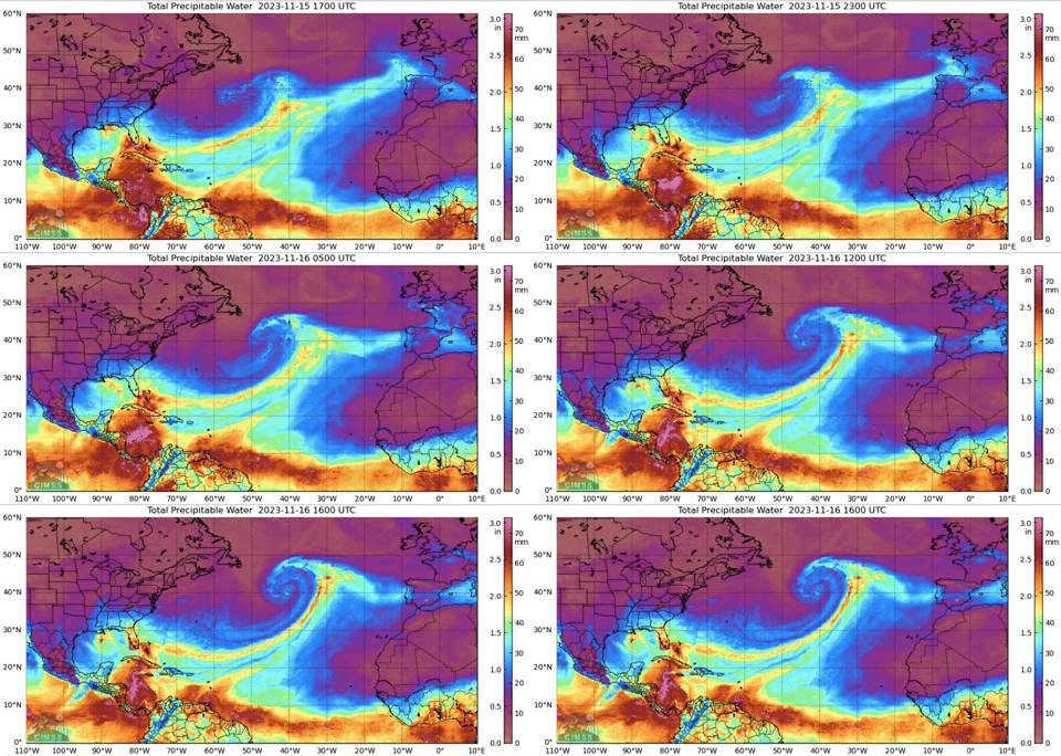
ATL: TWENTY-TWO - Remnants - Discussion

Moderator: S2k Moderators

Message
Author
User avatar
cycloneye
Admin
Admin
Posts: 139081
Age: 67
Joined: Thu Oct 10, 2002 10:54 am
Location: San Juan, Puerto Rico

ATL: TWENTY-TWO - Remnants - Discussion

#1 Postby cycloneye » Wed Nov 15, 2023 1:36 pm

AL, 98, 2023111518, , BEST, 0, 117N, 811W, 30, 1007, DB, 34, NEQ, 0, 0, 0, 0, 1010, 200, 100, 0, 0, L, 0, , 0, 0, INVEST, S, 0, , 0, 0, 0, 0, genesis-num, 046, SPAWNINVEST, al722023 to al982023,


https://ftp.nhc.noaa.gov/atcf/btk/bal982023.dat

Thread at Talking TRopics forum that was the topic for this area.

https://www.storm2k.org/phpbb2/viewtopi ... 1&t=123857

Image
0 likes   
Visit the Caribbean-Central America Weather Thread where you can find at first post web cams,radars
and observations from Caribbean basin members Click Here

Sciencerocks
Category 5
Category 5
Posts: 7286
Age: 38
Joined: Thu Jul 06, 2017 1:51 am

Re: ATL: INVEST 98L - Discussion

#2 Postby Sciencerocks » Wed Nov 15, 2023 2:10 pm

Image
0 likes   

User avatar
ElectricStorm
Category 5
Category 5
Posts: 4541
Age: 23
Joined: Tue Aug 13, 2019 11:23 pm
Location: Skiatook, OK / Norman, OK

Re: ATL: INVEST 98L - Discussion

#3 Postby ElectricStorm » Wed Nov 15, 2023 3:50 pm

Should be the last chance at development this season I would think. Most models outside of the GFS keep it very weak. Highly sheared TD/minimal TS at the most here but most likely no development.
0 likes   
I am in no way a professional. Take what I say with a grain of salt as I could be totally wrong. Please refer to the NHC, NWS, or SPC for official information.

Boomer Sooner!

LarryWx
Category 5
Category 5
Posts: 5700
Joined: Sun Sep 07, 2003 2:04 pm
Location: GA

Re: ATL: INVEST 98L - Discussion

#4 Postby LarryWx » Wed Nov 15, 2023 4:16 pm

ElectricStorm wrote:Should be the last chance at development this season I would think. Most models outside of the GFS keep it very weak. Highly sheared TD/minimal TS at the most here but most likely no development.


The normally conservative UKMET is a major exception as it has a 68 knot cat 1 H (978 mb) near and past Bermuda as was posted in the models thread. Is it on crack? Maybe it is.

https://www.storm2k.org/phpbb2/viewtopi ... 0#p3054520
0 likes   
Personal Forecast Disclaimer:
The posts in this forum are NOT official forecasts and should not be used as such. They are just the opinion of the poster and may or may not be backed by sound meteorological data. They are NOT endorsed by any professional institution or storm2k.org. For official information, please refer to the NHC and NWS products.

User avatar
cycloneye
Admin
Admin
Posts: 139081
Age: 67
Joined: Thu Oct 10, 2002 10:54 am
Location: San Juan, Puerto Rico

Re: ATL: INVEST 98L - Discussion

#5 Postby cycloneye » Wed Nov 15, 2023 6:40 pm

Southwestern Caribbean Sea (AL98):
A broad area of low pressure over the southwestern Caribbean Sea is
producing a large area of disorganized showers and thunderstorms.
Environmental conditions appear marginally conducive for
development of this system over the next couple of days, and a
tropical depression could form by this weekend as the system
moves northeastward across the western and central part of the
Caribbean Sea. An Air Force Reserve reconnaissance aircraft is
scheduled to investigate the system tomorrow.

1. Regardless of development, this system is expected to produce heavy
rains that could result in flash flooding and mudslides over
portions of the Caribbean coast of Central America and the Greater
Antilles through this weekend. Interests in Jamaica, Cuba, Haiti,
the Dominican Republic, the southeastern Bahamas, and the Turks and
Caicos Islands should continue to monitor the progress of this
system.
* Formation chance through 48 hours...medium...40 percent.
* Formation chance through 7 days...medium...50 percent.
0 likes   
Visit the Caribbean-Central America Weather Thread where you can find at first post web cams,radars
and observations from Caribbean basin members Click Here

User avatar
cycloneye
Admin
Admin
Posts: 139081
Age: 67
Joined: Thu Oct 10, 2002 10:54 am
Location: San Juan, Puerto Rico

Re: ATL: INVEST 98L - Discussion

#6 Postby cycloneye » Wed Nov 15, 2023 8:04 pm

AL, 98, 2023111600, , BEST, 0, 124N, 815W, 30, 1007, DB


Image
0 likes   
Visit the Caribbean-Central America Weather Thread where you can find at first post web cams,radars
and observations from Caribbean basin members Click Here

User avatar
Hurricane2022
Category 4
Category 4
Posts: 921
Joined: Tue Aug 23, 2022 11:38 pm
Location: Araçatuba, Brazil

Re: ATL: INVEST 98L - Discussion

#7 Postby Hurricane2022 » Wed Nov 15, 2023 9:09 pm

cycloneye wrote:
AL, 98, 2023111600, , BEST, 0, 124N, 815W, 30, 1007, DB


https://i.imgur.com/h5heu8q.gif

Well...looks that we are finally experiencing what will possibly be the last tropical storm of the season. After predicting a modest hurricane for a little while...models and their ensembles have been very calm about this system for a few days now. The way 2023 has gone so far and will continue to go...I still wouldn't be extremely surprised or shocked by a greater development than expected from this system...even if the chances of that happening are (almost) 0% :lol:
1 likes   
Sorry for the bad English sometimes...!
For reliable and detailed information for any meteorological phenomenon, please consult the National Hurricane Center, Joint Typhoon Warning Center , or your local Meteo Center.

--------

Una cvm Christo, pro Christo, et in Christo. Sit nomen Domini benedictvm.

Sciencerocks
Category 5
Category 5
Posts: 7286
Age: 38
Joined: Thu Jul 06, 2017 1:51 am

Re: ATL: INVEST 98L - Discussion

#8 Postby Sciencerocks » Thu Nov 16, 2023 12:46 am

Image
0 likes   

User avatar
cycloneye
Admin
Admin
Posts: 139081
Age: 67
Joined: Thu Oct 10, 2002 10:54 am
Location: San Juan, Puerto Rico

Re: ATL: INVEST 98L - Discussion

#9 Postby cycloneye » Thu Nov 16, 2023 7:08 am

West-Central Caribbean Sea (AL98):
Showers and thunderstorms associated with a broad area of low
pressure located over the west-central Caribbean Sea have become a
little better organized since yesterday. Environmental conditions
appear conducive for some additional development, and a tropical
depression could form over the next day or two while the low moves
northeastward toward Jamaica, Haiti, and eastern Cuba. An Air
Force Reserve reconnaissance aircraft is scheduled to investigate
the system this afternoon.

Regardless of development, this system is expected to produce heavy
rains that could result in flash flooding and mudslides over
portions of the Greater Antilles through this weekend. Interests
in Jamaica, Cuba, Haiti, the Dominican Republic, the southeastern
Bahamas, and the Turks and Caicos Islands should continue to monitor
the progress of this system.
* Formation chance through 48 hours...medium...60 percent.
* Formation chance through 7 days...medium...60 percent.
0 likes   
Visit the Caribbean-Central America Weather Thread where you can find at first post web cams,radars
and observations from Caribbean basin members Click Here

User avatar
Nimbus
Category 5
Category 5
Posts: 4928
Joined: Mon Jul 19, 2004 10:54 am

Re: ATL: INVEST 98L - Discussion

#10 Postby Nimbus » Thu Nov 16, 2023 7:46 am

No rain for Florida and November systems tracking over Cuba east of Havana are often boring.
0 likes   

User avatar
TheEuropean
Professional-Met
Professional-Met
Posts: 1793
Age: 58
Joined: Tue Sep 20, 2005 3:17 pm
Location: Voerde, Germany
Contact:

Re: ATL: INVEST 98L - Discussion

#11 Postby TheEuropean » Thu Nov 16, 2023 7:55 am

Nimbus wrote:No rain for Florida and November systems tracking over Cuba east of Havana are often boring.


Not for people there.

In my eyes No tropical system is boring.
1 likes   
The above post is not official and should not be used as such. It is the opinion of the poster and may or may not be backed by sound meteorological data. It is not endorsed by any professional institution or storm2k.org. For official information, please refer to the NHC and NWS products.

User avatar
Jr0d
S2K Supporter
S2K Supporter
Posts: 1174
Joined: Tue Aug 27, 2019 10:52 am
Location: Cayo Hueso

Re: ATL: INVEST 98L - Discussion

#12 Postby Jr0d » Thu Nov 16, 2023 8:12 am

This may not get grabbed by the front off of Florida as the CMC suggests, this will certainly make it much less boring with possible Florida Keys and South Florida impacts in a few days.. though likely minimal.

If it misses the front connection, high pressure fills in pushing it west for a few days before the next front pulls it north and absorbs it. If this happen the Cuban and possibly Jamaican impact may be not be minimal.
0 likes   

MEANINGLESS_NUMBERS
Tropical Depression
Tropical Depression
Posts: 58
Joined: Mon Nov 02, 2020 1:43 pm

Re: ATL: INVEST 98L - Discussion

#13 Postby MEANINGLESS_NUMBERS » Thu Nov 16, 2023 8:17 am

Gale forecast for Bermuda this weekend. Could be TS with just a tiny change in track.
0 likes   

User avatar
cycloneye
Admin
Admin
Posts: 139081
Age: 67
Joined: Thu Oct 10, 2002 10:54 am
Location: San Juan, Puerto Rico

Re: ATL: INVEST 98L - Discussion

#14 Postby cycloneye » Thu Nov 16, 2023 8:35 am

AL, 98, 2023111612, , BEST, 0, 140N, 815W, 30, 1005, DB


Image
2 likes   
Visit the Caribbean-Central America Weather Thread where you can find at first post web cams,radars
and observations from Caribbean basin members Click Here

User avatar
Jr0d
S2K Supporter
S2K Supporter
Posts: 1174
Joined: Tue Aug 27, 2019 10:52 am
Location: Cayo Hueso

Re: ATL: INVEST 98L - Discussion

#15 Postby Jr0d » Thu Nov 16, 2023 8:37 am

MEANINGLESS_NUMBERS wrote:Gale forecast for Bermuda this weekend. Could be TS with just a tiny change in track.

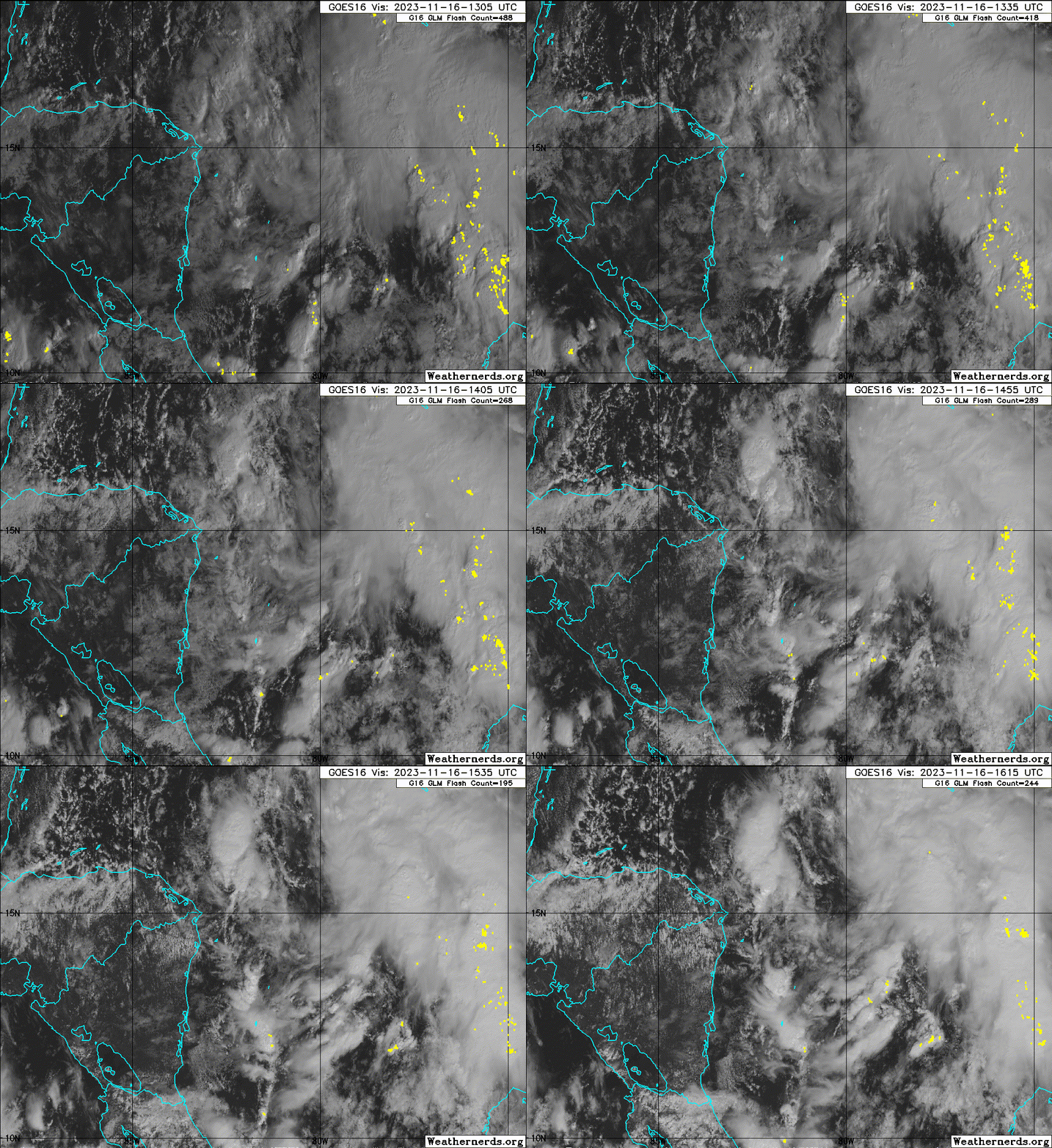
Is this from the area off of South Florida or the Caribbean?

Tough to say, I give this system at least a 50/50.of not get getting pulled north out of the Caribbean like the CMC is showing. Ensembles are split also with the majority going north...
0 likes   

Sciencerocks
Category 5
Category 5
Posts: 7286
Age: 38
Joined: Thu Jul 06, 2017 1:51 am

Re: ATL: INVEST 98L - Discussion

#16 Postby Sciencerocks » Thu Nov 16, 2023 11:38 am

Looks like an LLC around ~16.5/79.5? I wouldn't be shocked to see a depression or maybe a minimum tropical storm force in the next couple of days.
Image
0 likes   

User avatar
ScottNAtlanta
Category 5
Category 5
Posts: 1998
Joined: Sat May 25, 2013 3:11 pm
Location: Atlanta, GA

Re: ATL: INVEST 98L - Discussion

#17 Postby ScottNAtlanta » Thu Nov 16, 2023 12:33 pm

Looking at satellite, this is improving pretty quickly. I wasn't very bullish on it yesterday, but its actually got some convection and spin today. Just depends on how long it takes before it is pulled north over the islands. Not much shear but a whole lot of ventilation opportunities
0 likes   
The posts in this forum are NOT official forecast and should not be used as such. They are just the opinion of the poster and may or may not be backed by sound meteorological data. They are NOT endorsed by any professional institution or storm2k.org. For official information, please refer to the NHC and NWS products.

floridasun
Tropical Storm
Tropical Storm
Posts: 107
Joined: Tue Sep 14, 2021 3:59 pm

Re: ATL: INVEST 98L - Discussion

#18 Postby floridasun » Thu Nov 16, 2023 12:40 pm

Look like Bermuda may get blast from two systems one from none tropical low and 98l as both move ne
0 likes   

User avatar
cycloneye
Admin
Admin
Posts: 139081
Age: 67
Joined: Thu Oct 10, 2002 10:54 am
Location: San Juan, Puerto Rico

Re: ATL: INVEST 98L - Discussion

#19 Postby cycloneye » Thu Nov 16, 2023 12:44 pm

West-Central Caribbean Sea (AL98):
Satellite data indicate that the circulation associated with a low
pressure area over the west-central Caribbean Sea remains broad,
but the system is producing a large area of showers and
thunderstorms mainly to the east of the center of circulation.
Environmental conditions appear conducive for some additional
development, and a tropical depression is likely to form over the
next day or two while the low moves northeastward toward Jamaica,
Haiti, and eastern Cuba. An Air Force Reserve reconnaissance
aircraft is en route to investigate the system.

Regardless of development, this system is expected to produce heavy
rains which would likely result in flash flooding and mudslides over
portions of the Greater Antilles, particularly over Jamaica and
Hispaniola, through this weekend. Interests in Jamaica, Cuba,
Haiti, the Dominican Republic, the southeastern Bahamas, and the
Turks and Caicos Islands should continue to monitor the progress of
this system. Tropical storm watches could be required for some of
these areas as early as this afternoon.
* Formation chance through 48 hours...high...70 percent.
* Formation chance through 7 days...high...70 percent.
0 likes   
Visit the Caribbean-Central America Weather Thread where you can find at first post web cams,radars
and observations from Caribbean basin members Click Here

User avatar
REDHurricane
Tropical Storm
Tropical Storm
Posts: 206
Age: 26
Joined: Sun Jul 03, 2022 2:36 pm
Location: Northeast Pacific Ocean

Re: ATL: INVEST 98L - Discussion

#20 Postby REDHurricane » Thu Nov 16, 2023 12:50 pm

Structure has organized pretty quickly in the last ~12 hours; if the shear environment continues to improve I think this could develop into a TD or even Vince within the next day or so -- probably won't have enough time to intensify into anything more than a high-end TS though before it gets sucked up into the messy frontal tomfoolery happening to its north (emphasis on "probably" since anything is possible in the tropics, as we've learned from recent events)


925mb vort --------------------------------------- 700mb vort --------------------------------------- 500mb vort
Image

Image

Image
3 likes   


Return to “2023”

Who is online

Users browsing this forum: No registered users and 80 guests