ATL: BERYL - Post-Tropical - Discussion
Moderator: S2k Moderators

Re: ATL: BERYL - Hurricane - Discussion
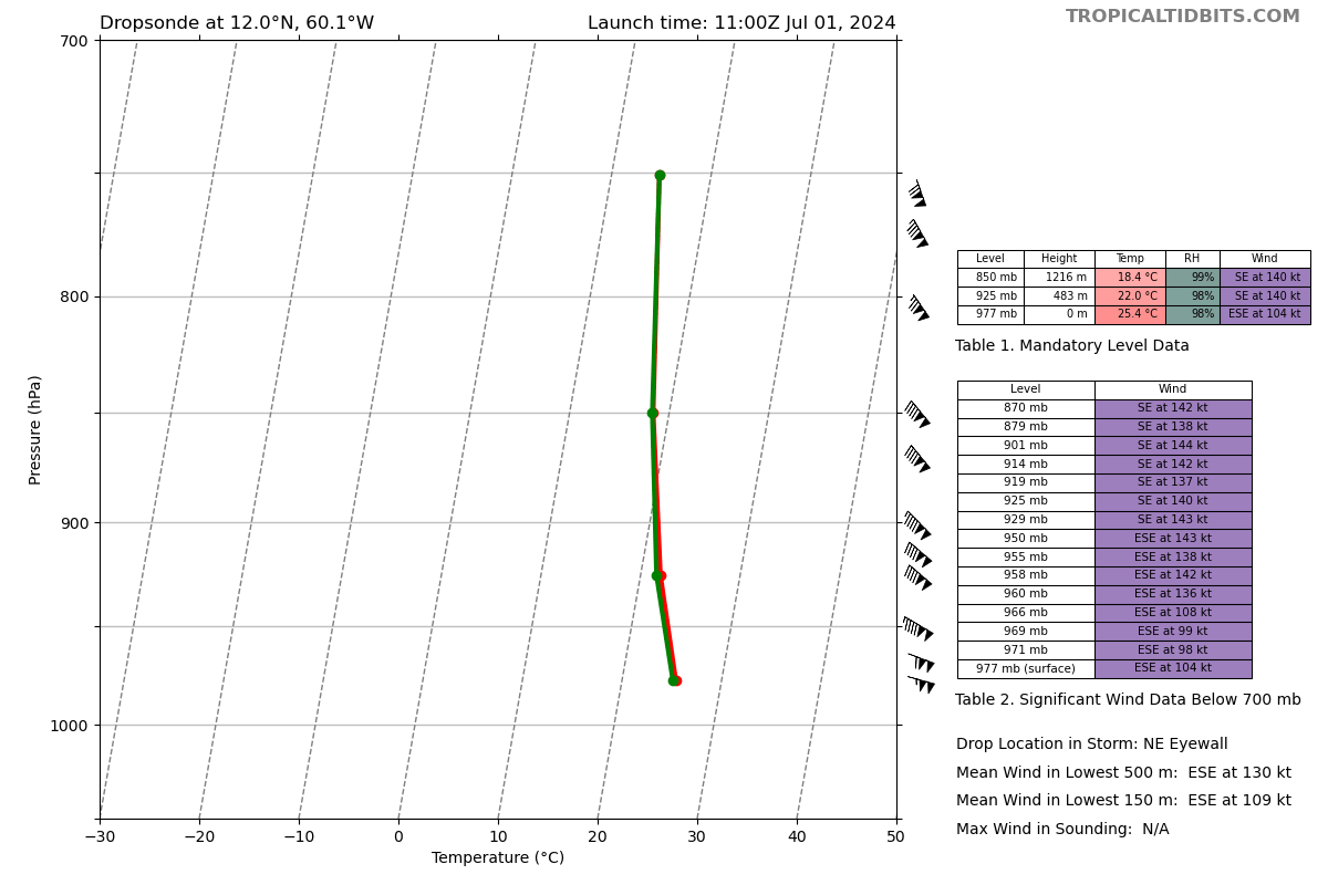
Looks to be a Cat 4 again. ~130 kt FL and ~125 kt SFMR in the NW eyewall, extrap pressure of 957.0 mbar.
1 likes
Irene '11 Sandy '12 Hermine '16 5/15/2018 Derecho Fay '20 Isaias '20 Elsa '21 Henri '21 Ida '21
I am only a meteorology enthusiast who knows a decent amount about tropical cyclones. Look to the professional mets, the NHC, or your local weather office for the best information.
I am only a meteorology enthusiast who knows a decent amount about tropical cyclones. Look to the professional mets, the NHC, or your local weather office for the best information.
-
Keldeo1997
- Category 2

- Posts: 688
- Joined: Fri Oct 11, 2019 11:35 pm
Re: ATL: BERYL - Hurricane - Discussion

130KT FL 122kt SFMR
Idk if I buy it. Pressure is way too high for those winds.
0 likes

Re: ATL: BERYL - Hurricane - Discussion
Keldeo1997 wrote:Idk if I buy it. Pressure is way too high for those winds.
Not as high as its first 115 kt peak, though (albeit just barely).
0 likes
TC naming lists: retirements and intensity
Most aggressive Advisory #1's in North Atlantic (cr. kevin for starting the list)
Most aggressive Advisory #1's in North Atlantic (cr. kevin for starting the list)

Re: ATL: BERYL - Hurricane - Discussion
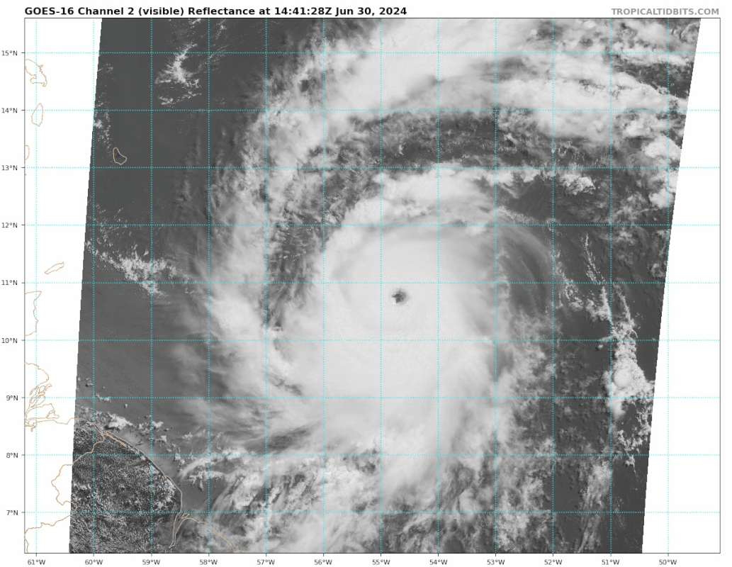
Beryl has doubled in size since first becoming a hurricane. Grenada and the Grenadines will likely feel her full wrath.
2 likes
Igor 2010, Sandy 2012, Fay 2014, Gonzalo 2014, Joaquin 2015, Nicole 2016, Humberto 2019, Imelda 2025
I am only a tropical weather enthusiast. My predictions are not official and may or may not be backed by sound meteorological data. For official information, please refer to the NHC and NWS products.
I am only a tropical weather enthusiast. My predictions are not official and may or may not be backed by sound meteorological data. For official information, please refer to the NHC and NWS products.
-
ColdMiser123

- Professional-Met

- Posts: 905
- Age: 29
- Joined: Mon Sep 26, 2016 3:26 pm
- Location: Northeast US
Re: ATL: BERYL - Hurricane - Discussion
9z center was 11.7N/59.9W. Plane just found the center at 11.9N/60.3 W.
At that current pace, the actual center should pass Grenada to the north - but severe impacts are still likely there due to the larger southern eyewall.
At that current pace, the actual center should pass Grenada to the north - but severe impacts are still likely there due to the larger southern eyewall.
2 likes
B.S., M.S., Meteorology & Atmospheric Science
Re: ATL: BERYL - Hurricane - Discussion
The second recon plane also found Cat 4 winds (~130 kt FL, ~120 kt SFMR) in the NE eyewall. So it looks like this is indeed a Cat 4 despite its high pressure.
Last edited by aspen on Mon Jul 01, 2024 7:00 am, edited 1 time in total.
3 likes
Irene '11 Sandy '12 Hermine '16 5/15/2018 Derecho Fay '20 Isaias '20 Elsa '21 Henri '21 Ida '21
I am only a meteorology enthusiast who knows a decent amount about tropical cyclones. Look to the professional mets, the NHC, or your local weather office for the best information.
I am only a meteorology enthusiast who knows a decent amount about tropical cyclones. Look to the professional mets, the NHC, or your local weather office for the best information.
-
ColdMiser123
- Professional-Met
- Posts: 905
- Age: 29
- Joined: Mon Sep 26, 2016 3:26 pm
- Location: Northeast US
Re: ATL: BERYL - Hurricane - Discussion
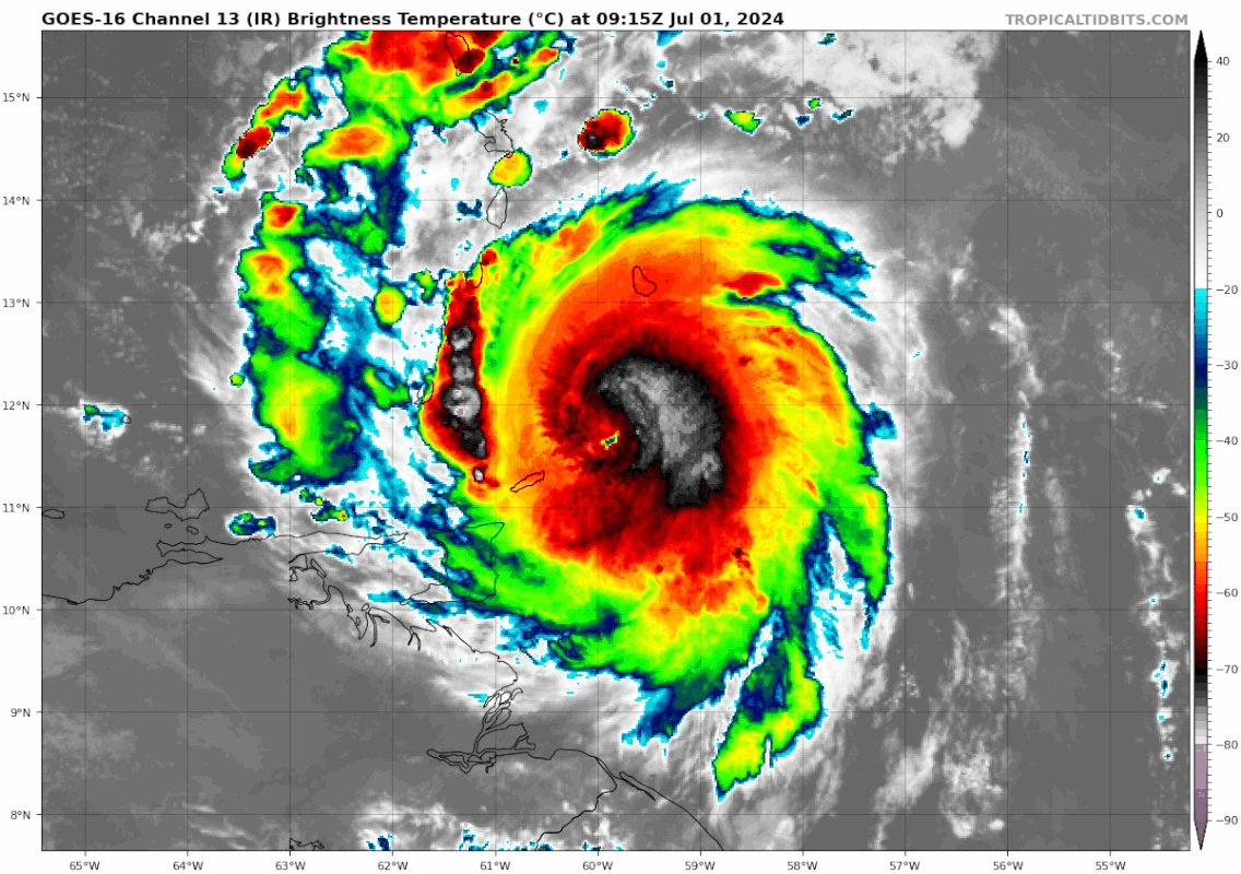
Should start to see trochoidal wobbles due to the current mass imbalance within the CDO.
The persistent deep convection upshear across the eastern semicircle over the last few days may have been why Beryl verified a little farther south with its initial short term motion over the last couple days.
The persistent deep convection upshear across the eastern semicircle over the last few days may have been why Beryl verified a little farther south with its initial short term motion over the last couple days.
1 likes
B.S., M.S., Meteorology & Atmospheric Science
Re: ATL: BERYL - Hurricane - Discussion
140 kt winds exist aloft in the NE eyewall. Wonder how long it will take to mix them down...
3 likes
TC naming lists: retirements and intensity
Most aggressive Advisory #1's in North Atlantic (cr. kevin for starting the list)
Most aggressive Advisory #1's in North Atlantic (cr. kevin for starting the list)
Re: ATL: BERYL - Hurricane - Discussion
From a pretty cane to an angry cane in 22 hours, yet at the same intensity (unofficial, pending 8am EDT update):
4 likes
TC naming lists: retirements and intensity
Most aggressive Advisory #1's in North Atlantic (cr. kevin for starting the list)
Most aggressive Advisory #1's in North Atlantic (cr. kevin for starting the list)
Re: ATL: BERYL - Hurricane - Discussion
Officially back to Cat 4
000
WTNT32 KNHC 011153
TCPAT2
BULLETIN
Hurricane Beryl Intermediate Advisory Number 11A
NWS National Hurricane Center Miami FL AL022024
800 AM AST Mon Jul 01 2024
...HURRICANE HUNTER AIRCRAFT DATA INDICATE BERYL HAS STRENGTHENED
TO AN EXTREMELY DANGEROUS CATEGORY 4 HURRICANE...
...LIFE-THREATENING WINDS AND STORM SURGE EXPECTED TO BEGIN IN THE
WINDWARD ISLANDS THIS MORNING...
SUMMARY OF 800 AM AST...1200 UTC...INFORMATION
----------------------------------------------
LOCATION...12.0N 60.5W
ABOUT 70 MI...125 KM E OF GRENADA
ABOUT 90 MI...165 KM SSE OF ST. VINCENT
MAXIMUM SUSTAINED WINDS...130 MPH...215 KM/H
PRESENT MOVEMENT...WNW OR 285 DEGREES AT 20 MPH...31 KM/H
MINIMUM CENTRAL PRESSURE...959 MB...28.32 INCHES
4 likes
TC naming lists: retirements and intensity
Most aggressive Advisory #1's in North Atlantic (cr. kevin for starting the list)
Most aggressive Advisory #1's in North Atlantic (cr. kevin for starting the list)


Re: ATL: BERYL - Hurricane - Discussion
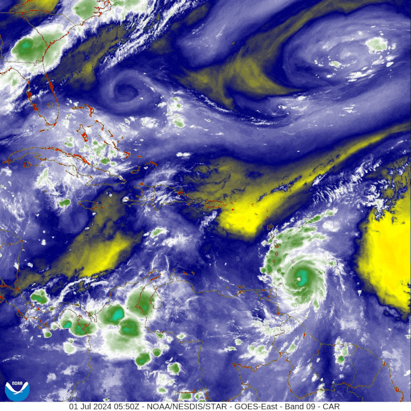
I'm afraid that the Grenadines are going to feel the wrath of a re-deepening Beryl. Cat 5 may not be out of the question in a matter of hours. REALLY cold tops beginning to wrap around the west to southwest quads 
3 likes
Andy D
(For official information, please refer to the NHC and NWS products.)
(For official information, please refer to the NHC and NWS products.)
-
Category5Kaiju

- Category 5

- Posts: 4326
- Joined: Thu Dec 24, 2020 12:45 pm
- Location: Seattle and Phoenix
Re: ATL: BERYL - Hurricane - Discussion
I keep forgetting that we still have some hours to go before landfall. Who knows how much it will strengthen now that the EWRC is complete?
4 likes
Unless explicitly stated, all info in my posts is based on my own opinions and observations. Tropical storms and hurricanes can be extremely dangerous. Refer to an accredited weather research agency or meteorologist if you need to make serious decisions regarding an approaching storm.
Re: ATL: BERYL - Hurricane - Discussion
Lol this pass supports a low-950s 130kt Cat 4. What a strange storm. I don’t recall seeing a system with such high winds at such high pressures.
3 likes
Irene '11 Sandy '12 Hermine '16 5/15/2018 Derecho Fay '20 Isaias '20 Elsa '21 Henri '21 Ida '21
I am only a meteorology enthusiast who knows a decent amount about tropical cyclones. Look to the professional mets, the NHC, or your local weather office for the best information.
I am only a meteorology enthusiast who knows a decent amount about tropical cyclones. Look to the professional mets, the NHC, or your local weather office for the best information.

Re: ATL: BERYL - Hurricane - Discussion
Oh my! Grenada may just make it into Southern side of the storm but those other islands to the North are in real trouble.
1 likes
The following post is NOT an official forecast and should not be used as such. It is just the opinion of the poster and may or may not be backed by sound meteorological data. It is NOT endorsed by any professional institution including storm2k.org For Official Information please refer to the NHC and NWS products.
-
Hurricane2022

- Category 5
- Posts: 2014
- Joined: Tue Aug 23, 2022 11:38 pm
- Location: Araçatuba, Brazil
Re: ATL: BERYL - Hurricane - Discussion
I'm ready to see Beryl peaking at 150 kt/940 mb
4 likes
Sorry for the bad English sometimes...!
For reliable and detailed information for any meteorological phenomenon, please consult the National Hurricane Center, Joint Typhoon Warning Center , or your local Meteo Center.
--------
ECCE OMNIA NOVA FACIAM (Ap 21,5).
For reliable and detailed information for any meteorological phenomenon, please consult the National Hurricane Center, Joint Typhoon Warning Center , or your local Meteo Center.
--------
ECCE OMNIA NOVA FACIAM (Ap 21,5).
Re: ATL: BERYL - Hurricane - Discussion
aspen wrote:Lol this pass supports a low-950s 130kt Cat 4. What a strange storm. I don’t recall seeing a system with such high winds at such high pressures.
Given it's 133 kt FL, 133 kt SFMR, I feel it's more likely that the NHC may discard the SFMR reading as being inflated at high wind speeds, similar to what they’ve been doing the last few years.
0 likes
TC naming lists: retirements and intensity
Most aggressive Advisory #1's in North Atlantic (cr. kevin for starting the list)
Most aggressive Advisory #1's in North Atlantic (cr. kevin for starting the list)
-
Category5Kaiju
- Category 5
- Posts: 4326
- Joined: Thu Dec 24, 2020 12:45 pm
- Location: Seattle and Phoenix
Re: ATL: BERYL - Hurricane - Discussion
aspen wrote:Lol this pass supports a low-950s 130kt Cat 4. What a strange storm. I don’t recall seeing a system with such high winds at such high pressures.
I think it has to do with the background pressures/gradient. Nicole 2016 was 140/950, and Omar 2008 was 130/958 iirc
3 likes
Unless explicitly stated, all info in my posts is based on my own opinions and observations. Tropical storms and hurricanes can be extremely dangerous. Refer to an accredited weather research agency or meteorologist if you need to make serious decisions regarding an approaching storm.
Re: ATL: BERYL - Hurricane - Discussion
Good morning Beryl.

8 likes
Igor 2010, Sandy 2012, Fay 2014, Gonzalo 2014, Joaquin 2015, Nicole 2016, Humberto 2019, Imelda 2025
I am only a tropical weather enthusiast. My predictions are not official and may or may not be backed by sound meteorological data. For official information, please refer to the NHC and NWS products.
I am only a tropical weather enthusiast. My predictions are not official and may or may not be backed by sound meteorological data. For official information, please refer to the NHC and NWS products.
Who is online
Users browsing this forum: No registered users and 10 guests