Good evening everyone
I posted this question in the models but so far no response. When the last storm cam in north of Tampa I had storm surge here in Key Largo. Yes that storm came up further south hopefully more than this one.
Do any of the pro's or knowledgeable people here think I need to be concern with surge/ leaving tomorrow for Europe.
ATL: MILTON - Post-Tropical - Discussion
Moderator: S2k Moderators
-
Miami Storm Tracker

- Category 4

- Posts: 916
- Age: 68
- Joined: Sun Jun 13, 2010 10:12 pm
- Location: Key Largo, Fla.
- Contact:
-
Flwxguy86

- Tropical Depression

- Posts: 51
- Age: 39
- Joined: Sun Sep 15, 2024 11:06 am
- Location: Oldsmar,FL
Re: ATL: MILTON - Hurricane - Discussion
norva13x wrote:Flwxguy86 wrote:NDG wrote:Weird how they didn't really change the forecast track despite the TVCN and TVCX consensus model right over Tampa Bay.
They did note: Users are reminded
to not focus on the details of the forecast as there remains
significant uncertainty in the eventual track and intensity of
Milton.
I do want to point out, while we don't always know why they decide where exactly to put the track, they usually are right. I say that desperately wishing it weren't the case as my home is in the bullseye right now.
I tend to agree but I mean your talking about the difference of maybe what 30 something miles from making landfall on St. Pete Beach vs Bradenton Beach and only maybe what 45 miles from Sarasota Beach? These are the kind of little wobbles that add up in the long range of a forecast that can't be accounted for this far out.
2 likes
-
grapealcoholic
- Category 2

- Posts: 703
- Joined: Tue Aug 10, 2021 3:26 pm

-
InfernoFlameCat

- Category 5

- Posts: 2127
- Age: 22
- Joined: Mon Dec 14, 2020 10:52 am
- Location: Buford, GA
Re: ATL: MILTON - Hurricane - Discussion
Eye is popping out on IR. This thing is bombing out. Hopefully shear devastates this system as it approaches Florida.
2 likes
I am by no means a professional. DO NOT look at my forecasts for official information or make decisions based on what I post.
Goal: to become a registered expert over tropical and subtropical cyclones.
Goal: to become a registered expert over tropical and subtropical cyclones.

Re: ATL: MILTON - Hurricane - Discussion
Miami Storm Tracker wrote:Good evening everyone
I posted this question in the models but so far no response. When the last storm cam in north of Tampa I had storm surge here in Key Largo. Yes that storm came up further south hopefully more than this one.
Do any of the pro's or knowledgeable people here think I need to be concern with surge/ leaving tomorrow for Europe.
Nobody can know that. Look to your local NWS. Best guess for me is that it will come up pretty far west. But if you live on a boat or immediate coast you have to pay attention to what the government says if a foot or two matters.
4 likes
-
ConvergenceZone
.gif)
- Category 5
- Posts: 5241
- Joined: Fri Jul 29, 2005 1:40 am
- Location: Northern California
Re: ATL: MILTON - Hurricane - Discussion
I know that wxman mentioned earlier that he predicts a landfall between Port Charlotte and Sarasota, but that it could potentially go as far south as Fort Myers
0 likes
-
Miami Storm Tracker
- Category 4
- Posts: 916
- Age: 68
- Joined: Sun Jun 13, 2010 10:12 pm
- Location: Key Largo, Fla.
- Contact:
Re: ATL: MILTON - Hurricane - Discussion
Thank you for your response, as you say you never really know. I was a little surprised a week ago, but it did come up from the south off Key west
1 likes
Re: ATL: MILTON - Hurricane - Discussion
Steve wrote:Miami Storm Tracker wrote:Good evening everyone
I posted this question in the models but so far no response. When the last storm cam in north of Tampa I had storm surge here in Key Largo. Yes that storm came up further south hopefully more than this one.
Do any of the pro's or knowledgeable people here think I need to be concern with surge/ leaving tomorrow for Europe.
Nobody can know that. Look to your local NWS. Best guess for me is that it will come up pretty far west. But if you live on a boat or immediate coast you have to pay attention to what the government says if a foot or two matters.
As someone that lives very near the Pinellas beaches that were devastated, find the local surge forecast and believe the highest end can occur as it did here.
3 likes
-
Blown Away

- S2K Supporter

- Posts: 10253
- Joined: Wed May 26, 2004 6:17 am
Re: ATL: MILTON - Hurricane - Discussion
Latest
7 likes
Hurricane Eye Experience: David 79, Irene 99, Frances 04, Jeanne 04, Wilma 05… Hurricane Brush Experience: Andrew 92, Erin 95, Floyd 99, Matthew 16, Irma 17, Ian 22, Nicole 22…

Re: ATL: MILTON - Hurricane - Discussion
Sick to my stomach right now in Sanford Florida. Roughly 20 miles NE of Orlando proper. Have gotten away for the duration of my 15 years here without any notable storm damage or power outages longer than 12 hours or so, but I feel our luck is coming to an end. Contemplating whether we should board up. A good chunk of the models are putting hurricane force winds on my head, if not the eyewall itself. Just moved my grandparents down here, one of which has Alzheimer's and the other is effectively immobile. I will be the first to admit that storms with higher damage potential, wherever they are slated to go, are more interesting for me to watch, from a hobbyist perspective, but being truly under the gun has given me a newfound appreciation for the real world scenarios that people affected by these events find themselves in. I cannot imagine the level of impending doom I would be feeling were I on the west coast. My heart truly goes out to those in worse places than me.
Anyways, sorry mods, I hope that wasn't too off topic for this thread. You guys do incredible work, old school forums of this caliber and activity level are a dying breed, and you all are truly doing something special in maintaining the level of discussion that occurs here. We should all cherish this place and work to keep it alive. Headed to donate after I post this.
On a side note, does anyone have any resources for volunteering opportunities related to recovery efforts?
17 likes
-
USTropics
- Professional-Met

- Posts: 2736
- Joined: Sun Aug 12, 2007 3:45 am
- Location: Florida State University
Re: ATL: MILTON - Hurricane - Discussion
cheezyWXguy wrote:Bluehawk wrote:LandoWill wrote:They made a big shift this morning south, and it was quite extreme and maybe they caught some flack from the people that be and they are being more conservative with their changes now until tomorrow
I very rarely post, as I am here to learn from those who know. My thought about NHC not changing the track further north is that it might have to do more with handling the social part of their work (soft science) rather than the meteorological part of it. Their job is not just to make scientifical weather determinations, but to also do everything possible to get the message in such a way that people listen—extremely difficult task. Having watched one of their afternoon updates, they were mentioning that we should expect to see watches and warnings in the morning for pretty much everyone in the cone. I would think they want to be able to put watches as down south as possible, because I am seeing an extreme caution from most decisions makers this time, more than I have seen with any other hurricane. Perhaps it is easier to make the decision to cancel schools, for example, if you are under a hurricane watch and in the cone, than if you are not, and, to give the decision too late, with all the rain S FL has been having, might not be the best decision.
You’re absolutely right that their job is to balance accuracy with effective public messaging. A track that shifts back and forth too quickly would fly in the face of the latter. The cone is just a tool, albeit a valuable one, but is superseded by the watches and warnings you mention. They explicitly warn against focusing on the center line, and the width of the cone exists at it is, independent of uncertainty in the moment.
Therefore, regardless of the cone, the message is: if you’re in a hurricane watch or warning, prepare for a hurricane. Plain and simple.
This. It's important to not focus on the center of the cone. The NHC explicitly mentions this in the discussion as well (there is a track error for a reason). Some of our data from the upper level atmospheric sampling mission will be in the 00z model runs, so it would make sense to see how the model solutions respond before any track adjustments are needed. The NHC adjusted the cone about ~50 miles east in as little as 3 hours for Helene:


2 likes

Re: ATL: MILTON - Hurricane - Discussion
Steve wrote:Miami Storm Tracker wrote:Good evening everyone
I posted this question in the models but so far no response. When the last storm cam in north of Tampa I had storm surge here in Key Largo. Yes that storm came up further south hopefully more than this one.
Do any of the pro's or knowledgeable people here think I need to be concern with surge/ leaving tomorrow for Europe.
Nobody can know that. Look to your local NWS. Best guess for me is that it will come up pretty far west. But if you live on a boat or immediate coast you have to pay attention to what the government says if a foot or two matters.
You mention flying to Europe tomorrow (Monday). I assume your concern is whether storm surge tomorrow will flood the roads in Key Largo causing you to miss your flight? No, there should not be any storm surge tomorrow affecting the Upper Keys. Give yourself extra drive time because there probably will be a lot of traffic though.
2 likes
Andy D
(For official information, please refer to the NHC and NWS products.)
(For official information, please refer to the NHC and NWS products.)
-
Hypercane_Kyle

- Category 5
- Posts: 3465
- Joined: Sat Mar 07, 2015 7:58 pm
- Location: Cape Canaveral, FL
Re: ATL: MILTON - Hurricane - Discussion
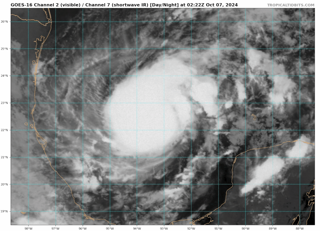
Pretty clear on IR this thing is about to pull a trick right out of 2005-GOMEX playbook. Small, distinct eye getting ready to pop.
6 likes
My posts are my own personal opinion, defer to the National Hurricane Center (NHC) and other NOAA products for decision making during hurricane season.
-
Kingarabian

- S2K Supporter
- Posts: 16338
- Joined: Sat Aug 08, 2009 3:06 am
- Location: Honolulu, Hawaii
Re: ATL: MILTON - Hurricane - Discussion
Ignoring constraints, if the LG in the eye persists (eye clearing out) then this is a T6.0, meaning it's bombing out into a major hurricane. If the B shade persists then it will remain a T5.0 which would favor a solid Cat.2 over the next few hours. So far the winds have been lagging its satellite appearance.

Last edited by Kingarabian on Sun Oct 06, 2024 11:12 pm, edited 1 time in total.
7 likes
RIP Kobe Bryant


Re: ATL: MILTON - Hurricane - Discussion

Can't imagine that pressure doesn't start falling through the floor overnight.
9 likes
-
StPeteMike

- Category 2
- Posts: 653
- Joined: Thu Jun 07, 2018 11:26 pm
Re: ATL: MILTON - Hurricane - Discussion
Landy wrote:https://media.discordapp.net/attachments/877402829797621770/1292700579835019356/goes16_g16meso2_band13_20241007040858.png?ex=6704b0bb&is=67035f3b&hm=9b1ff3dfeb550fbd757e2b8d12f9d84d6946ef1860e6a73ad78f9b7a922e4da8&=&format=webp&quality=lossless&width=783&height=666
Can't imagine that pressure doesn't start falling through the floor overnight.
He’s going to get that skull look soon…
1 likes
The above post is not official and should not be used as such. It is the opinion of the poster and may or may not be backed by sound meteorological data. It is not endorsed by any professional institution or storm2k.org. For official information, please refer to the NHC and NWS products.
-
Anti-freeze
- Tropical Storm

- Posts: 109
- Joined: Tue Jan 02, 2024 8:26 pm
Re: ATL: MILTON - Hurricane - Discussion
Looking at the potential storm surge maps, this is likely to be a very expensive disaster.
0 likes
Re: ATL: MILTON - Hurricane - Discussion
pmang6 wrote:Sick to my stomach right now in Sanford Florida. Roughly 20 miles NE of Orlando proper. Have gotten away for the duration of my 15 years here without any notable storm damage or power outages longer than 12 hours or so, but I feel our luck is coming to an end. Contemplating whether we should board up. A good chunk of the models are putting hurricane force winds on my head, if not the eyewall itself. Just moved my grandparents down here, one of which has Alzheimer's and the other is effectively immobile. I will be the first to admit that storms with higher damage potential, wherever they are slated to go, are more interesting for me to watch, from a hobbyist perspective, but being truly under the gun has given me a newfound appreciation for the real world scenarios that people affected by these events find themselves in. I cannot imagine the level of impending doom I would be feeling were I on the west coast. My heart truly goes out to those in worse places than me.
Anyways, sorry mods, I hope that wasn't too off topic for this thread. You guys do incredible work, old school forums of this caliber and activity level are a dying breed, and you all are truly doing something special in maintaining the level of discussion that occurs here. We should all cherish this place and work to keep it alive. Headed to donate after I post this.
On a side note, does anyone have any resources for volunteering opportunities related to recovery efforts?
That's really a great question?? I think a great idea for each Hurricane landfall event would be to have a "sticky" with names and contact info for both donations and volunteer efforts. So many people want to step forward following the scenes of anguish and destruction, yet I would have no clue where to focus my efforts or refer someone. I'm suggesting some true list beyond the passive suggestion of contact the United Way, or to simply suggest contacting your church.
3 likes
Andy D
(For official information, please refer to the NHC and NWS products.)
(For official information, please refer to the NHC and NWS products.)
Re: ATL: MILTON - Hurricane - Discussion
[imgur]https://imgur.com/a/BmRM4Mo[/imgur]
I'm certainly not experienced enough to know for sure, but it would appear that he is beginning to clear out his eye.
EDIT: anyone care to give me a hand on adding photos/gifs? The instructions in the imgur tooltip do not appear to work, or, more likely, I am missing something. And I thought I knew how to work a vBulletin style forum!
Last edited by pmang6 on Sun Oct 06, 2024 11:25 pm, edited 2 times in total.
1 likes
Who is online
Users browsing this forum: No registered users and 11 guests