cycloneye wrote:
Oh no. Galveston / Houston on the strongest side.
I’ve been concerned about the ICON for a while. Now the EURO is strongly on board. Here we go again…
Moderator: S2k Moderators

cycloneye wrote:
Oh no. Galveston / Houston on the strongest side.

IcyTundra wrote:18Z Euro Ensemble slightly further east than the 12Z and the mean is near Sargent
https://i.ibb.co/Trmr6cB/AL02-2024070518-ECENS-0-120h-large.png
ROCK wrote:IcyTundra wrote:18Z Euro Ensemble slightly further east than the 12Z and the mean is near Sargent
https://i.ibb.co/Trmr6cB/AL02-2024070518-ECENS-0-120h-large.png
Fully expect the cone to shift at 10pm to the right along with the warning. JMO..
GalvestonDuck wrote:cycloneye wrote:
Oh no. Galveston / Houston on the strongest side.
I’ve been concerned about the ICON for a while. Now the EURO is strongly on board. Here we go again…

IcyTundra wrote:18Z Euro Ensemble slightly further east than the 12Z and the mean is near Sargent
https://i.ibb.co/Trmr6cB/AL02-2024070518-ECENS-0-120h-large.png
Steve wrote:Update on the FV3, hard to tell. Only has it down to 989mb at 47 hours which is good news if that was to verify but moving north and slightly deepening. We'll see where that goes.
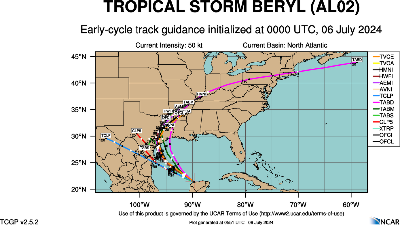
00Z Early Cycle still likes the middle Texas Coast. Believable if it stays relatively weak.
https://hurricanes.ral.ucar.edu/realtim ... _early.png
FV3 Pretty close to landfall down the coast from Galveston Bay around 988.
https://www.tropicaltidbits.com/analysi ... 0600&fh=51
Steve wrote:FV-3 comes in down coast from Galveston Bay but decided to move up toward Houston and Beaumont at the end. Doesn't have things terrible - 980's. But that would be a mix of coastal and low lying flooding, probably tropical storm conditions for lots of people and all that brings, but not the worst of the worst case. If it's right, that's kind of a day I'd be into if I lived around Houston. Stock up on the provisions and such and steer clear of downed wires and flooded streets.
https://www.tropicaltidbits.com/analysi ... 0600&fh=60

catskillfire51 wrote:Icon - Landfall on Freeport. 973mb
Steve wrote:catskillfire51 wrote:Icon - Landfall on Freeport. 973mb
I'm not betting against it and don't assume anyone else is either. What happens after, and where does it predict the most accumulated precipitation? I want to check that vs. what happens next Monday - Tuesday.
Users browsing this forum: No registered users and 138 guests


