ATL: HELENE - Post-Tropical - Discussion

Moderator: S2k Moderators

Message
Author
User avatar
ObsessedMiami
Category 1
Category 1
Posts: 431
Joined: Tue Aug 31, 2004 8:08 pm
Location: West Kendall, Fl

Re: ATL: HELENE - Tropical Storm - Discussion

#1081 Postby ObsessedMiami » Tue Sep 24, 2024 4:31 pm

Michele B wrote:
ObsessedMiami wrote:My brother is in Liberty County pretty close to the center of the cone and is agonizing to stay or go. He has a prefab home that did well in Michael but is trying to see if they end up on the western side. But I understand that the wind field will be large with Helene. Will it be large to the west of center or more so east?
Thanks for all you guys do


Local authorities should give guidance for your brother.

Often, people ignore the advice given them, OR they think "That isn't my area...."

But the Emergency authorities have looked at lots more data than we've got access to and make an informed decision to save as many lives as possible.

NEVER ignore advice given on whether to stay or evacuate.

Of course. Appreciate you taking the time to respond. Thank you
0 likes   

User avatar
ronjon
Category 5
Category 5
Posts: 4822
Joined: Fri Aug 19, 2005 5:17 pm
Location: Hernando Beach, FL

Re: ATL: HELENE - Tropical Storm - Discussion

#1082 Postby ronjon » Tue Sep 24, 2024 4:32 pm

LandoWill wrote:They seem pretty confident with predicting the panhandle/big bend area as landfall.(no warnings for tampa coast) I'm expecting where I'm on the west coast, north of Tampa to probably get winds equal to what we get after a cold front comes by, so i don't think I'll be doing much more than unless something changes tomorrow. Luckily i do live a little further inland from the beach.


A cold front?..there is a hurricane warning from Anclote River (Pinellas-Pasco Border) north which includes Pasco, Hernando and Citrus Counties and a tropical storm warning for Tampa Bay. There is a storm surge warning for Tampa Bay of 5-8 feet. There is a storm surge warning for the coast from Anclote River north of 6-10 feet.
5 likes   

User avatar
eastcoastFL
Category 5
Category 5
Posts: 3901
Age: 43
Joined: Thu Apr 12, 2007 12:29 pm
Location: Palm City, FL

Re: ATL: HELENE - Tropical Storm - Discussion

#1083 Postby eastcoastFL » Tue Sep 24, 2024 4:35 pm

Surprised to see watches go up here in Martin county but I guess this is going to be an enormous storm in size. I guess we will see where it's heading tomorrow and if those will be dropped or upgrades to warnings.

I hope all those to my north and west and finishing their preps or beginning their evacuations. Helene might not look like much at the moment but 24 hours from now she will likely be a hurricane and the window for evacuations and preps will be closing at that point.
1 likes   
Personal Forecast Disclaimer:
The posts in this forum are NOT official forecast and should not be used as such. They are just the opinion of the poster and may or may not be backed by sound meteorological data. They are NOT endorsed by any professional institution or storm2k.org. For official information, please refer to the NHC and NWS products.

PavelGaborik10
Category 1
Category 1
Posts: 455
Joined: Tue Sep 04, 2018 3:23 pm

Re: ATL: HELENE - Tropical Storm - Discussion

#1084 Postby PavelGaborik10 » Tue Sep 24, 2024 4:36 pm

For the first time I can say I'm impressed with Helene.

Outflow has improved leaps and bounds, freezing cold tops shooting over/near the center.

It's going to be an interesting night tonight to say the least
6 likes   

skillz305
Category 1
Category 1
Posts: 279
Joined: Sat Sep 08, 2018 11:10 am
Location: Miami, Florida --> Vero Beach, Florida

Re: ATL: HELENE - Tropical Storm - Discussion

#1085 Postby skillz305 » Tue Sep 24, 2024 4:38 pm

eastcoastFL wrote:Surprised to see watches go up here in Martin county but I guess this is going to be an enormous storm in size. I guess we will see where it's heading tomorrow and if those will be dropped or upgrades to warnings.

I hope all those to my north and west and finishing their preps or beginning their evacuations. Helene might not look like much at the moment but 24 hours from now she will likely be a hurricane and the window for evacuations and preps will be closing at that point.


Indian River here. Was surprised to see the "TS Watch" at 5pm as well.
4 likes   
:flag:Hurricanes: Andrew 1992 - Irene 1999 - Frances 2004 - Jeanne 2004 - Katrina 2005 - Wilma 2005 - Matthew 2016 - Irma 2017 - Ian 2022 - Nicole 2022 - Milton 2024

User avatar
eastcoastFL
Category 5
Category 5
Posts: 3901
Age: 43
Joined: Thu Apr 12, 2007 12:29 pm
Location: Palm City, FL

Re: ATL: HELENE - Tropical Storm - Discussion

#1086 Postby eastcoastFL » Tue Sep 24, 2024 4:38 pm

LandoWill wrote:They seem pretty confident with predicting the panhandle/big bend area as landfall.(no warnings for tampa coast) I'm expecting where I'm on the west coast, north of Tampa to probably get winds equal to what we get after a cold front comes by, so i don't think I'll be doing much more than unless something changes tomorrow. Luckily i do live a little further inland from the beach.


There are warnings up and down the West Coast and watches on the East Coast from Martin county to Central GA. If you're north of Tampa you might want to stay tuned and start your hurricane preparations tonight. Get water and fuel at the very least.
0 likes   
Personal Forecast Disclaimer:
The posts in this forum are NOT official forecast and should not be used as such. They are just the opinion of the poster and may or may not be backed by sound meteorological data. They are NOT endorsed by any professional institution or storm2k.org. For official information, please refer to the NHC and NWS products.

User avatar
eastcoastFL
Category 5
Category 5
Posts: 3901
Age: 43
Joined: Thu Apr 12, 2007 12:29 pm
Location: Palm City, FL

Re: ATL: HELENE - Tropical Storm - Discussion

#1087 Postby eastcoastFL » Tue Sep 24, 2024 4:40 pm

skillz305 wrote:
eastcoastFL wrote:Surprised to see watches go up here in Martin county but I guess this is going to be an enormous storm in size. I guess we will see where it's heading tomorrow and if those will be dropped or upgrades to warnings.

I hope all those to my north and west and finishing their preps or beginning their evacuations. Helene might not look like much at the moment but 24 hours from now she will likely be a hurricane and the window for evacuations and preps will be closing at that point.


Indian River here. Was surprised to see the "TS Watch" at 5pm as well.


I was just looking at the Melbourne NWS page. I guess the watches are just for the coastal areas and inland and western parts of the treasure Coast are in warnings.
0 likes   
Personal Forecast Disclaimer:
The posts in this forum are NOT official forecast and should not be used as such. They are just the opinion of the poster and may or may not be backed by sound meteorological data. They are NOT endorsed by any professional institution or storm2k.org. For official information, please refer to the NHC and NWS products.

Frank P
S2K Supporter
S2K Supporter
Posts: 2776
Joined: Fri Aug 29, 2003 10:52 am
Location: Biloxi Beach, Ms
Contact:

Re: ATL: HELENE - Tropical Storm - Discussion

#1088 Postby Frank P » Tue Sep 24, 2024 4:41 pm

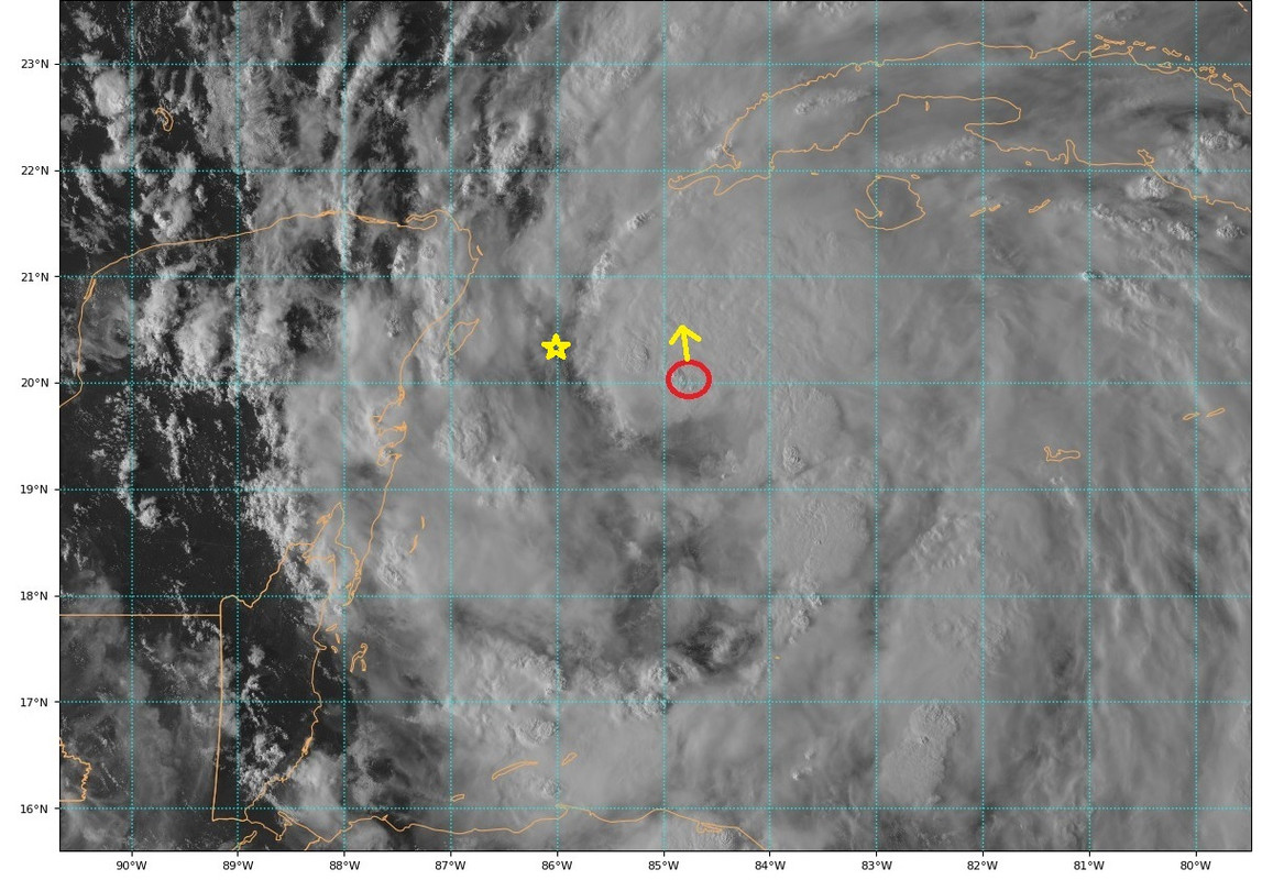
Once the area around west and southwest of the center circled in blue fills in its show time, convection in the red area is doing its part.
Image
2 likes   

User avatar
aspen
Category 5
Category 5
Posts: 8818
Joined: Sat Oct 12, 2019 7:10 pm
Location: Connecticut, USA

Re: ATL: HELENE - Tropical Storm - Discussion

#1089 Postby aspen » Tue Sep 24, 2024 4:43 pm

We’ve got a pair of recon planes en route to Helene. Interested to see if the gradual improvement on visible has translated to any appreciable deepening.
2 likes   
Irene '11 Sandy '12 Hermine '16 5/15/2018 Derecho Fay '20 Isaias '20 Elsa '21 Henri '21 Ida '21

I am only a meteorology enthusiast who knows a decent amount about tropical cyclones. Look to the professional mets, the NHC, or your local weather office for the best information.

User avatar
Zonacane
Category 1
Category 1
Posts: 361
Joined: Tue Aug 03, 2021 2:23 pm

Re: ATL: HELENE - Tropical Storm - Discussion

#1090 Postby Zonacane » Tue Sep 24, 2024 4:44 pm

Frank P wrote:Once the area around west and southwest of the center circled in blue fills in its show time, convection in the red area is doing its part.
https://i.ibb.co/TtZ13kF/goes16-g16meso1-band02-20240924213128.png

You can see towers going up on that band on the leading edge of the area you marked. Won’t be long until that wraps in
2 likes   

skillz305
Category 1
Category 1
Posts: 279
Joined: Sat Sep 08, 2018 11:10 am
Location: Miami, Florida --> Vero Beach, Florida

Re: ATL: HELENE - Tropical Storm - Discussion

#1091 Postby skillz305 » Tue Sep 24, 2024 4:44 pm

eastcoastFL wrote:
skillz305 wrote:
eastcoastFL wrote:Surprised to see watches go up here in Martin county but I guess this is going to be an enormous storm in size. I guess we will see where it's heading tomorrow and if those will be dropped or upgrades to warnings.

I hope all those to my north and west and finishing their preps or beginning their evacuations. Helene might not look like much at the moment but 24 hours from now she will likely be a hurricane and the window for evacuations and preps will be closing at that point.


Indian River here. Was surprised to see the "TS Watch" at 5pm as well.


I was just looking at the Melbourne NWS page. I guess the watches are just for the coastal areas and inland and western parts of the treasure Coast are in warnings.


If you use Ventusky, it shows Central FL getting gusts of 60mph on thursday afternoon, and thats with a big bend landfall... Crazy
1 likes   
:flag:Hurricanes: Andrew 1992 - Irene 1999 - Frances 2004 - Jeanne 2004 - Katrina 2005 - Wilma 2005 - Matthew 2016 - Irma 2017 - Ian 2022 - Nicole 2022 - Milton 2024

User avatar
eastcoastFL
Category 5
Category 5
Posts: 3901
Age: 43
Joined: Thu Apr 12, 2007 12:29 pm
Location: Palm City, FL

Re: ATL: HELENE - Tropical Storm - Discussion

#1092 Postby eastcoastFL » Tue Sep 24, 2024 4:45 pm

Winds are spiking and pressure is plummeting at buoy
42056. Down to 994mb

https://www.ndbc.noaa.gov/show_plot.php ... _label=EDT
4 likes   
Personal Forecast Disclaimer:
The posts in this forum are NOT official forecast and should not be used as such. They are just the opinion of the poster and may or may not be backed by sound meteorological data. They are NOT endorsed by any professional institution or storm2k.org. For official information, please refer to the NHC and NWS products.

longhorn2004
Tropical Depression
Tropical Depression
Posts: 61
Joined: Fri Oct 06, 2017 1:49 pm

Re: ATL: HELENE - Tropical Storm - Discussion

#1093 Postby longhorn2004 » Tue Sep 24, 2024 4:47 pm

What is the steering mechanism? We have a cold front moving in from the northwest here in Texas.
1 likes   

User avatar
Ubuntwo
Category 5
Category 5
Posts: 1406
Age: 31
Joined: Thu Oct 05, 2017 10:41 pm

Re: ATL: HELENE - Tropical Storm - Discussion

#1094 Postby Ubuntwo » Tue Sep 24, 2024 4:47 pm

aspen wrote:We’ve got a pair of recon planes en route to Helene. Interested to see if the gradual improvement on visible has translated to any appreciable deepening.

We already have a buoy reporting a pressure of 995.3mb with a 17 knot wind, so it has absolutely deepened and the pressure is still dropping.
3 likes   
Kendall -> SLO -> PBC

Memorable Storms: Katrina (for its Florida landfall...) Wilma Matthew Irma

User avatar
Blown Away
S2K Supporter
S2K Supporter
Posts: 10147
Joined: Wed May 26, 2004 6:17 am

Re: ATL: HELENE - Tropical Storm - Discussion

#1095 Postby Blown Away » Tue Sep 24, 2024 4:48 pm

Image
FORECAST POSITIONS AND MAX WINDS

INIT 24/2100Z 19.7N 84.7W 45 KT 50 MPH
12H 25/0600Z 20.4N 86.0W 55 KT 65 MPH


Helene supposed to pass 20.4 an 86.0 in 12 hours, IMO still chugging away NNW...
Last edited by Blown Away on Tue Sep 24, 2024 4:51 pm, edited 2 times in total.
1 likes   
Hurricane Eye Experience: David 79, Irene 99, Frances 04, Jeanne 04, Wilma 05... EYE COMING MY WAY IN 2024…
Hurricane Brush Experience: Andrew 92, Erin 95, Floyd 99, Matthew 16, Irma 17, Ian 22, Nicole 22…

Pipelines182
Tropical Storm
Tropical Storm
Posts: 159
Joined: Tue Jul 02, 2024 8:46 am

Re: ATL: HELENE - Tropical Storm - Discussion

#1096 Postby Pipelines182 » Tue Sep 24, 2024 4:48 pm

ronjon wrote:
LandoWill wrote:They seem pretty confident with predicting the panhandle/big bend area as landfall.(no warnings for tampa coast) I'm expecting where I'm on the west coast, north of Tampa to probably get winds equal to what we get after a cold front comes by, so i don't think I'll be doing much more than unless something changes tomorrow. Luckily i do live a little further inland from the beach.


A cold front?..there is a hurricane warning from Anclote River (Pinellas-Pasco Border) north which includes Pasco, Hernando and Citrus Counties and a tropical storm warning for Tampa Bay. There is a storm surge warning for Tampa Bay of 5-8 feet. There is a storm surge warning for the coast from Anclote River north of 6-10 feet.


I guess you could argue the storm of the century in 1993 was technically a cold front when it rolled through Tampa lol
1 likes   

User avatar
eastcoastFL
Category 5
Category 5
Posts: 3901
Age: 43
Joined: Thu Apr 12, 2007 12:29 pm
Location: Palm City, FL

Re: ATL: HELENE - Tropical Storm - Discussion

#1097 Postby eastcoastFL » Tue Sep 24, 2024 4:50 pm

skillz305 wrote:
eastcoastFL wrote:
skillz305 wrote:

Indian River here. Was surprised to see the "TS Watch" at 5pm as well.


I was just looking at the Melbourne NWS page. I guess the watches are just for the coastal areas and inland and western parts of the treasure Coast are in warnings.


If you use Ventusky, it shows Central FL getting gusts of 60mph on thursday afternoon, and thats with a big bend landfall... Crazy


Highest winds on my local forecast are Thursday afternoon around 1pm at 30mph w. 50mph gusts. So I guess that has the potential for TS conditions.
0 likes   
Personal Forecast Disclaimer:
The posts in this forum are NOT official forecast and should not be used as such. They are just the opinion of the poster and may or may not be backed by sound meteorological data. They are NOT endorsed by any professional institution or storm2k.org. For official information, please refer to the NHC and NWS products.

MJGarrison
Tropical Storm
Tropical Storm
Posts: 146
Joined: Wed Aug 30, 2017 7:26 pm

Re: ATL: HELENE - Tropical Storm - Discussion

#1098 Postby MJGarrison » Tue Sep 24, 2024 4:50 pm

Since we’re dealing with the 90th percentile in size, I would imagine that a drop in pressure would not necessarily correlate to the same windspeed increase as it would for a smaller storm.


Sent from my iPhone using Tapatalk
1 likes   

grapealcoholic
Category 2
Category 2
Posts: 684
Joined: Tue Aug 10, 2021 3:26 pm

Re: ATL: HELENE - Tropical Storm - Discussion

#1099 Postby grapealcoholic » Tue Sep 24, 2024 4:51 pm

993.9 :double:

free fall
4 likes   

User avatar
Zonacane
Category 1
Category 1
Posts: 361
Joined: Tue Aug 03, 2021 2:23 pm

Re: ATL: HELENE - Tropical Storm - Discussion

#1100 Postby Zonacane » Tue Sep 24, 2024 4:52 pm

MJGarrison wrote:Since we’re dealing with the 90th percentile in size, I would imagine that a drop in pressure would not necessarily correlate to the same windspeed increase as it would for a smaller storm.


Sent from my iPhone using Tapatalk

Depends on the size of the core.
1 likes   


Return to “2024”

Who is online

Users browsing this forum: No registered users and 4 guests