ATL: MILTON - Post-Tropical - Discussion
Moderator: S2k Moderators

Re: ATL: MILTON - Hurricane - Discussion
If we’re discarding SFMR, would this support 130 kt/941 mbar?
0 likes
Irene '11 Sandy '12 Hermine '16 5/15/2018 Derecho Fay '20 Isaias '20 Elsa '21 Henri '21 Ida '21
I am only a meteorology enthusiast who knows a decent amount about tropical cyclones. Look to the professional mets, the NHC, or your local weather office for the best information.
I am only a meteorology enthusiast who knows a decent amount about tropical cyclones. Look to the professional mets, the NHC, or your local weather office for the best information.

Re: ATL: MILTON - Hurricane - Discussion
I’m sorry did Milton just skip cat 4 entirely? That’s absolutely unheard of.
2 likes
Igor 2010, Sandy 2012, Fay 2014, Gonzalo 2014, Joaquin 2015, Nicole 2016, Humberto 2019, Imelda 2025
I am only a tropical weather enthusiast. My predictions are not official and may or may not be backed by sound meteorological data. For official information, please refer to the NHC and NWS products.
I am only a tropical weather enthusiast. My predictions are not official and may or may not be backed by sound meteorological data. For official information, please refer to the NHC and NWS products.
-
Canelaw99

- S2K Supporter

- Posts: 2128
- Age: 49
- Joined: Tue Aug 31, 2004 8:27 am
- Location: Homestead, FL
Re: ATL: MILTON - Hurricane - Discussion
Jr0d wrote:While the current compact size hopefully will prevent widespread surge we saw with Katrina, it tracking across the Gulf will likely enhance surge in SW Florida, maybe the Yucatan will somewhat block this effect but doubtful as the wind field is forecast to expand after Milton passes by the peninsula. The high swells from the storm will be an erosion problem all around the gulf also.
I really do not know what to do. The models show Key West being relatively safe with the extreme winds(and high surge) just missing us, as Milton keeps drifting slightly south of the forecast, it makes weary of an extreme impact instead of the predicted tropical storm conditions.
Evacuating is starting to look more reasonable by the hour for myself and many others in the lower Florida Keys.
Unlike the other storms we go brushed with, most lower keys/Key West residents are extremely concerned about Milton, especially those who were there for Wilma..
You could always look at evacuating to our area here in Homestead/S Miami area. Not too far from KW but far enough from surge and all.
2 likes

Re: ATL: MILTON - Hurricane - Discussion
Hypercane_Kyle wrote:100% at least a 130 knot Category 4 based on that pass. SFMR might be high-biased due to shoaling.
That area of the Gulf is deep....I doubt shoaling would be an issue, though SFMR always has some uncertainty, even without shoaling or flagged readings.
1 likes

Re: ATL: MILTON - Hurricane - Discussion
FLpanhandle91 wrote:Looks like NOAA took a minute to get their minds right before punching lol.
Pucker factor exponentially rising
2 likes
Re: ATL: MILTON - Hurricane - Discussion
939.0mb extrapolated from NOAA
3 likes
Irene '11 Sandy '12 Hermine '16 5/15/2018 Derecho Fay '20 Isaias '20 Elsa '21 Henri '21 Ida '21
I am only a meteorology enthusiast who knows a decent amount about tropical cyclones. Look to the professional mets, the NHC, or your local weather office for the best information.
I am only a meteorology enthusiast who knows a decent amount about tropical cyclones. Look to the professional mets, the NHC, or your local weather office for the best information.
Re: ATL: MILTON - Hurricane - Discussion
GCANE wrote:FLpanhandle91 wrote:Looks like NOAA took a minute to get their minds right before punching lol.
Pucker factor exponentially rising
What’s the pucker factor?
0 likes
Irene '11 Sandy '12 Hermine '16 5/15/2018 Derecho Fay '20 Isaias '20 Elsa '21 Henri '21 Ida '21
I am only a meteorology enthusiast who knows a decent amount about tropical cyclones. Look to the professional mets, the NHC, or your local weather office for the best information.
I am only a meteorology enthusiast who knows a decent amount about tropical cyclones. Look to the professional mets, the NHC, or your local weather office for the best information.
Re: ATL: MILTON - Hurricane - Discussion
Outflow is incredible.
Milton is blowing the top off the cell to the NE that is coming from its feeder band
Milton is blowing the top off the cell to the NE that is coming from its feeder band
3 likes
-
weeniepatrol

- Category 5

- Posts: 1339
- Joined: Sat Aug 22, 2020 5:30 pm
- Location: WA State
Re: ATL: MILTON - Hurricane - Discussion
...MILTON RAPIDLY INTENSIFIES INTO A CATEGORY 4 HURRICANE...
Data from both Hurricane Hunter aircraft indicate that Milton has
strengthened to a category 4 hurricane. The maximum sustained
winds are estimated to be 150 mph (240 km/h). Milton is a category
4 hurricane on the Saffir-Simpson Hurricane Wind Scale. Data
from the aircraft also indicate that the minimum pressure has
fallen to 940 mb (27.76 inches).
1 likes
Re: ATL: MILTON - Hurricane - Discussion
SUMMARY OF 805 AM CDT...1305 UTC...INFORMATION
----------------------------------------------
LOCATION...21.7N 92.0W
ABOUT 150 MI...240 KM W OF PROGRESO MEXICO
ABOUT 735 MI...1185 KM SW OF TAMPA FLORIDA
MAXIMUM SUSTAINED WINDS...150 MPH...240 KM/H
PRESENT MOVEMENT...ESE OR 115 DEGREES AT 8 MPH...13 KM/H
MINIMUM CENTRAL PRESSURE...940 MB...27.76 INCHES
0 likes
-
FLpanhandle91

- Category 5
- Posts: 1039
- Age: 34
- Joined: Mon Sep 13, 2010 3:50 pm
- Location: Fort Walton Beach, FL
Re: ATL: MILTON - Hurricane - Discussion
aspen wrote:GCANE wrote:FLpanhandle91 wrote:Looks like NOAA took a minute to get their minds right before punching lol.
Pucker factor exponentially rising
What’s the pucker factor?
Storms undergoing explosive intensification make for a more turbulent than normal center pass. Updrafts and downdrafts are hard to predict.
2 likes
-
dukeblue219
- S2K Supporter
- Posts: 556
- Joined: Fri Sep 30, 2016 3:52 pm
-
Sciencerocks
- Category 5
- Posts: 10181
- Age: 40
- Joined: Thu Jul 06, 2017 1:51 am
Re: ATL: MILTON - Hurricane - Discussion
aspen wrote:GCANE wrote:FLpanhandle91 wrote:Looks like NOAA took a minute to get their minds right before punching lol.
Pucker factor exponentially rising
What’s the pucker factor?
Aka you're probably risking your ass gong forward with your next action.
3 likes
-
Keldeo1997
- Category 2

- Posts: 688
- Joined: Fri Oct 11, 2019 11:35 pm
-
TallyTracker
- Category 2
- Posts: 787
- Joined: Thu Oct 11, 2018 2:46 pm
Re: ATL: MILTON - Hurricane - Discussion
Sunnydays wrote:I have family members leaving the Tampa area at noon today headed up and over to far NW Fla area. Is there a website anyone can recommend for following traffic and any possible standstills on the interstate systems that may occur due to evacuee traffic? Has anyone heard if Desantis has any ideas of contraflow? I know I75 was at a standstill in some areas last night. Just want to guide them the best I can to get them out of there the quickest way possible.
Take US 19 to I-10. It will take an extra 45 min - 1 hour but there is far less traffic. They can even take the Suncoast Parkway all the way to SR 44 now.
Google Traffic has been good for me most of the time.
2 likes
Fran '96, Georges '98, Gordon '00, Gabrielle '01, Charley '04, Frances '04, Jeanne '04, Barry '07, Fay '08, Debby '12, Matthew '16, Emily '17, Irma '17, Michael ‘18, Elsa ‘21, Fred ‘21, Mindy ‘21, Nicole ‘22, Idalia ‘23, Debby ‘24, Helene ‘24
-
HurricaneBelle

- S2K Supporter
- Posts: 1209
- Joined: Sun Aug 27, 2006 6:12 pm
- Location: Clearwater, FL
Re: ATL: MILTON - Hurricane - Discussion
My god this thing is like it's straight out of a cheesy disaster novel, and right now we're starting Chapter 3 where it begins "Jake had flown reconnaissance missions for the Hurricane Hunters for nearly 20 years and thought he had seen everything, but even he was taken aback by the ferocity of Milton's eyewall, watching a hurricane go nuclear before his very eyes."
9 likes
-
Hypercane_Kyle

- Category 5
- Posts: 3465
- Joined: Sat Mar 07, 2015 7:58 pm
- Location: Cape Canaveral, FL
Re: ATL: MILTON - Hurricane - Discussion
Unreal... even the hyperfueled HAFS runs didn't anticipate Milton already making a run for Category 5. <910mb seems entirely plausible.
3 likes
My posts are my own personal opinion, defer to the National Hurricane Center (NHC) and other NOAA products for decision making during hurricane season.

Re: ATL: MILTON - Hurricane - Discussion
The SW eyewall is the strongest, correct?
Or can it be that there's a side that's bigger in wind range but not necessarily stronger?

Or can it be that there's a side that's bigger in wind range but not necessarily stronger?
0 likes

Re: ATL: MILTON - Hurricane - Discussion
Milton, 23 hours ago: (Happened to be the last frame on my laptop before it refreshed today)
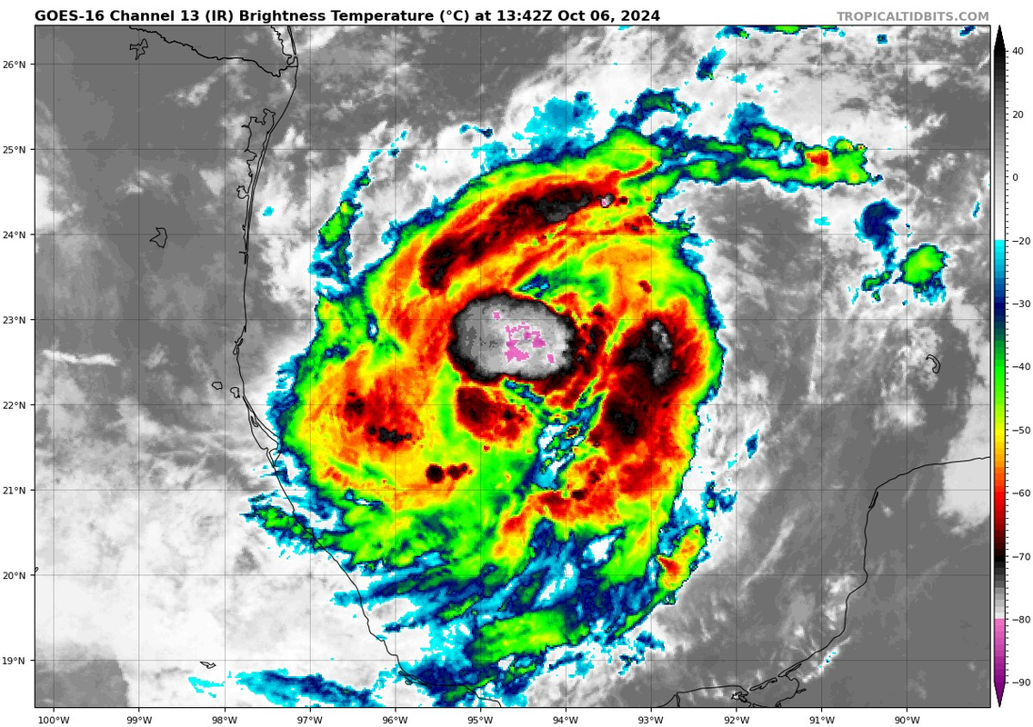
Milton, now:
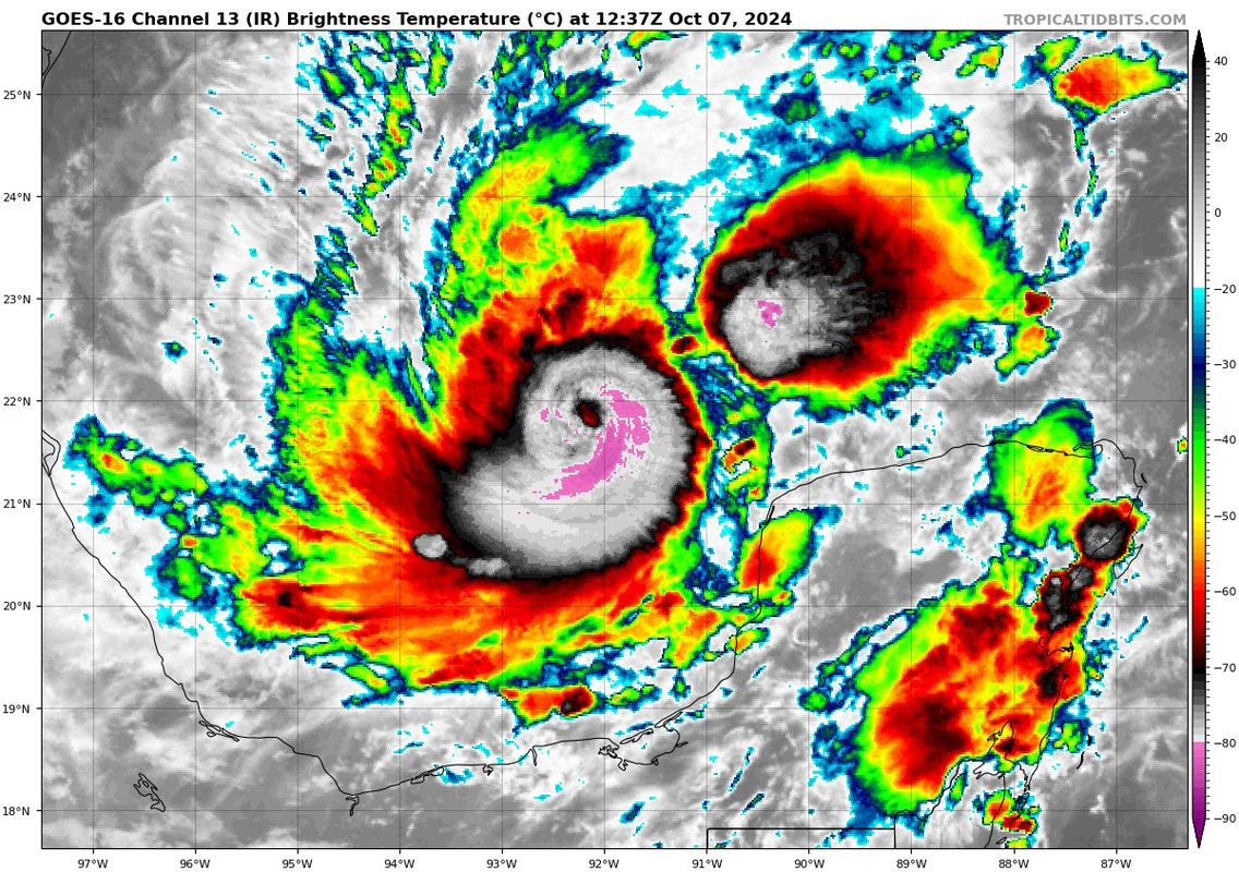
Milton, now:
12 likes
TC naming lists: retirements and intensity
Most aggressive Advisory #1's in North Atlantic (cr. kevin for starting the list)
Most aggressive Advisory #1's in North Atlantic (cr. kevin for starting the list)
Who is online
Users browsing this forum: No registered users and 34 guests