
ATL: FRANCINE - Remnants - Discussion
Moderator: S2k Moderators
-
WaveBreaking

- Category 2

- Posts: 717
- Joined: Sun Jun 30, 2024 11:33 am
- Location: US
Re: ATL: INVEST 91L - Discussion
Since yesterday, some of the strongest convection associated with 91L (brighter yellows) has started to make its way closer to the center instead of being a well-removed band out to the west. This prob won't mean anything once ex-90L merges with it tho.
0 likes
I am NOT a professional meteorologist, so take all of my posts with a grain of salt. My opinions are mine and mine alone.
-
cheezyWXguy

- Category 5

- Posts: 6281
- Joined: Mon Feb 13, 2006 12:29 am
- Location: Dallas, TX
Re: ATL: INVEST 91L - Discussion
Bimms wrote:I'm wondering about the impacts to the Houston Metro. I remember with Beryl, a lot of people on here were saying it was going to miss, but I kept saying it was going to be a direct hit, and it was. Starting to get similar vibes with this one if it develops. What are you thoughts?
We’ll have to see what the models show tonight once they’ve ingested recon data. Honestly I don’t think it’s going to change the track much, but might help narrow down the range on intensity. As 57 said, the track in these situations tends to shift east with time, and that was the case with Beryl. I was unsure yesterday about this, but it seems to have been the case over the last 24 hours. The consensus is already east of Houston with this one, so it seems unlikely to shift west.
2 likes

Re: ATL: INVEST 91L - Discussion
MGC wrote:Convective war zone down in the Gulf this morning. Looks like a sharp trough axis to me.....I see no well defined circulation, but one could be hiding in there somewhere. When and where a CC closes off if at all is anyone's guess. This has the potential to wrap up quickly as there is little shear over the disturbance currently. Looking like a Louisiana threat to me. Could be a major rainfall threat due to the recent heavy rains there......MGC
My thoughts exactly. Right now this is looking like quite a convoluted mess (aka sharp trough and fighting low level convergence to the north)
This is gonna be one hell of a rain maker for sure but wind and storm surge impact looks to eventually threaten near the Texas/Louisiana border area.
I think a high-end Cat 1 to Cat 2 is not out of the question given the potential for RI "if" an MLC can provide at least 48 hours over water. My guess is that a PTC advisories will
commence tonight or early tomorrow.
2 likes
Andy D
(For official information, please refer to the NHC and NWS products.)
(For official information, please refer to the NHC and NWS products.)

Re: ATL: INVEST 91L - Discussion
I wouldn’t characterize it as a convoluted mess - maybe a complex setup. But you can see the surface circulations beginning to interact which is part of the necessary process for this setup. This is a pretty rare situation for the Gulf and one I don’t recall seeing before. Seen a lot of waves interacting with lows but not llc’s merging.
https://www.tropicaltidbits.com/sat/sat ... t=vis_swir
https://www.tropicaltidbits.com/sat/sat ... t=vis_swir
1 likes
-
Kingarabian

- S2K Supporter

- Posts: 16345
- Joined: Sat Aug 08, 2009 3:06 am
- Location: Honolulu, Hawaii
Re: ATL: INVEST 91L - Discussion
Sort of a Harvey 2017 situation here. Models had this crashing into CA/BOC and now it's likely to spin up and affect the gulf states. Remains to be seen if the bullish 12z GFS and Euro runs verify.
0 likes
RIP Kobe Bryant

Re: ATL: INVEST 91L - Discussion
If recon reaches the southern vort near 19.84N -93.4W they will probably find similar surface pressures to the 90L "remnant" further north.
0 likes
Re: ATL: INVEST 91L - Discussion
Kingarabian wrote:Sort of a Harvey 2017 situation here. Models had this crashing into CA/BOC and now it's likely to spin up and affect the gulf states. Remains to be seen if the bullish 12z GFS and Euro runs verify.
957 is where GFS gets it down to which is potential strong 2 or even low end 3. EC looks 974 or decent 2. G-Cane might be onto something. I didn’t see those pressures but at a ceiling.
2 likes
-
LadyBug72

- Tropical Storm

- Posts: 121
- Joined: Mon Jun 01, 2020 3:39 pm
- Location: about 20 miles from Galveston, Tx
Re: ATL: INVEST 91L - Discussion
I’m about 20 miles from Galveston. I have family coming in from out of town Thursday for a funeral. What can we expect weather wise….still to early to tell? I’ve seen so many different stories. Thank you.
0 likes
Formerly known as the user: Nikki
Alicia 83, Allison 01, Rita 05, Ike 08, Harvey 17, Nicholas 21, Coastal Texas Derecho 24, Beryl 24
Alicia 83, Allison 01, Rita 05, Ike 08, Harvey 17, Nicholas 21, Coastal Texas Derecho 24, Beryl 24
-
ColdMiser123

- Professional-Met

- Posts: 905
- Age: 29
- Joined: Mon Sep 26, 2016 3:26 pm
- Location: Northeast US
Re: ATL: INVEST 91L - Discussion
Recon is finding plenty of mid-grade TS wind. Wind shift near the center, but still a bit broad.
The structure matches model short-term forecasts that had the strongest wind on the southwest side of 91L.
Recon is flying at very low altitudes, so the flight level wind is just above the surface.
The structure matches model short-term forecasts that had the strongest wind on the southwest side of 91L.
Recon is flying at very low altitudes, so the flight level wind is just above the surface.
Last edited by ColdMiser123 on Sun Sep 08, 2024 1:50 pm, edited 2 times in total.
2 likes
B.S., M.S., Meteorology & Atmospheric Science
Re: ATL: INVEST 91L - Discussion
LadyBug72 wrote:I’m about 20 miles from Galveston. I have family coming in from out of town Thursday for a funeral. What can we expect weather wise….still to early to tell? I’ve seen so many different stories. Thank you.
? Depends on how large the circulation is and what the track is. Seems to push up toward TX before fading NE. Condolences.
1 likes
-
LadyBug72
- Tropical Storm
- Posts: 121
- Joined: Mon Jun 01, 2020 3:39 pm
- Location: about 20 miles from Galveston, Tx
Re: ATL: INVEST 91L - Discussion
Steve wrote:LadyBug72 wrote:I’m about 20 miles from Galveston. I have family coming in from out of town Thursday for a funeral. What can we expect weather wise….still to early to tell? I’ve seen so many different stories. Thank you.
? Depends on how large the circulation is and what the track is. Seems to push up toward TX before fading NE. Condolences.
Thank you.
1 likes
Formerly known as the user: Nikki
Alicia 83, Allison 01, Rita 05, Ike 08, Harvey 17, Nicholas 21, Coastal Texas Derecho 24, Beryl 24
Alicia 83, Allison 01, Rita 05, Ike 08, Harvey 17, Nicholas 21, Coastal Texas Derecho 24, Beryl 24
-
wxman57

- Moderator-Pro Met

- Posts: 23171
- Age: 68
- Joined: Sat Jun 21, 2003 8:06 pm
- Location: Houston, TX (southwest)
Re: ATL: INVEST 91L - Discussion
ColdMiser123 wrote:Recon is finding plenty of mid-grade TS wind. Wind shift near the center, but still a bit broad.
The structure matches model short-term forecasts that had the strongest wind on the southwest side of 91L.
Recon is flying at very low altitudes, so the flight level wind is just above the surface.
That stronger NW-NNW wind recon is finding is due to cool air rushing down the coast of Mexico behind the front, not from any circulation center. Such winds are common down there behind fronts.
2 likes
-
wxman57
- Moderator-Pro Met
- Posts: 23171
- Age: 68
- Joined: Sat Jun 21, 2003 8:06 pm
- Location: Houston, TX (southwest)
Re: ATL: INVEST 91L - Discussion
LadyBug72 wrote:I’m about 20 miles from Galveston. I have family coming in from out of town Thursday for a funeral. What can we expect weather wise….still to early to tell? I’ve seen so many different stories. Thank you.
This system will be long gone by Thursday morning.
0 likes

Re: ATL: INVEST 91L - Discussion
All I have to say at the moment is, this is possibly one of the most complicated situations I've ever seen in the Gulf, and seems more akin to the West Pacific monsoon
4 likes
The above post is not official and should not be used as such. It is the opinion of the poster and may or may not be backed by sound meteorological data. It is not endorsed by any professional institution or storm2k.org. For official information, please refer to the NHC and NWS products.
Re: ATL: INVEST 91L - Discussion
Hammy wrote:All I have to say at the moment is, this is possibly one of the most complicated situations I've ever seen in the Gulf, and seems more akin to the West Pacific monsoon
Right. Definitely not something we are used to seeing happen in the west gulf even though the systems themselves weren’t all that strong.
1 likes
Re: ATL: INVEST 91L - Discussion
wxman57 wrote:ColdMiser123 wrote:Recon is finding plenty of mid-grade TS wind. Wind shift near the center, but still a bit broad.
The structure matches model short-term forecasts that had the strongest wind on the southwest side of 91L.
Recon is flying at very low altitudes, so the flight level wind is just above the surface.
That stronger NW-NNW wind recon is finding is due to cool air rushing down the coast of Mexico behind the front, not from any circulation center. Such winds are common down there behind fronts.
Those winds will probably help the west side of the circulation envelope
2 likes
Re: ATL: INVEST 91L - Discussion
wxman57 wrote:cycloneye wrote:Recon will go this afternoon and we will know if they find a TD, TS or not yet a cyclone.
Any TS wind today is due to cool air accelerating down the coast of Mexico rather than due to the developing circulation. Winds have been 35 kts along the MX coast for over 24 hours. Very common behind a front.
It'll be important to see where the center sets up over the next 24 hours. That will play a part in the eventual track. It appears that the storm will encounter increasing westerly winds aloft as it moves across the NW Gulf Tue-Wed. Initially, that could aid outflow and help it to strengthen. Eventually, though, it'll become shear and result in weakening. 12Z Consensus shifted west to Lake Charles area, but I think it's going to track east of there, possibly as far east as western Vermilion Bay. Models are almost always too far west in these setups.
TS wind could pass offshore Brownsville on Tuesday, maybe very near the coast. That would require the NHC to initiate PTC advisories today. Maybe they'll wait for recon reports, though.
That's heck of a front
SFMR Peak (10s) Sfc. Wind: 48 kts (55.2 mph)
Last edited by xironman on Sun Sep 08, 2024 2:23 pm, edited 1 time in total.
1 likes
-
MONTEGUT_LA

- Tropical Storm
- Posts: 105
- Joined: Sun Jul 20, 2003 7:29 pm
- Location: Montegut, Louisiana
Re: ATL: INVEST 91L - Discussion
TomballEd wrote:MONTEGUT_LA wrote:TomballEd wrote:
Almost all ensemble mebers keep this offshore Texas and hit Louisiana, maybe near Abbeville, where the seafood is quite good. If #91L can stay close enough to the coast, the rains could be significant. For now, the GFS/Euro/Canadian ensemble total rainfall in SETX is not too extreme. GFS mid 970s slowly rising as the system approaches Louisiana would probably be a Cat 1 hurricane. Euro is barely a TS, but going by Canadian, GFS and the ICON, a strong TS or minimal hurricane seems the most likely.
91L is still a mess, but a mess with storm tops approaching -90*C, it should organize if the convection stays with it.
Our parish had well over 12" of rain the past few days. Unfortunately, i dont think we can handle much more. I heard reports of water in homes in Houma. We still have ppl in fema trailers as well.
Landfall at New Iberia- Morgan City puts us on the dirty side. Hopefully it jets out of here quick.
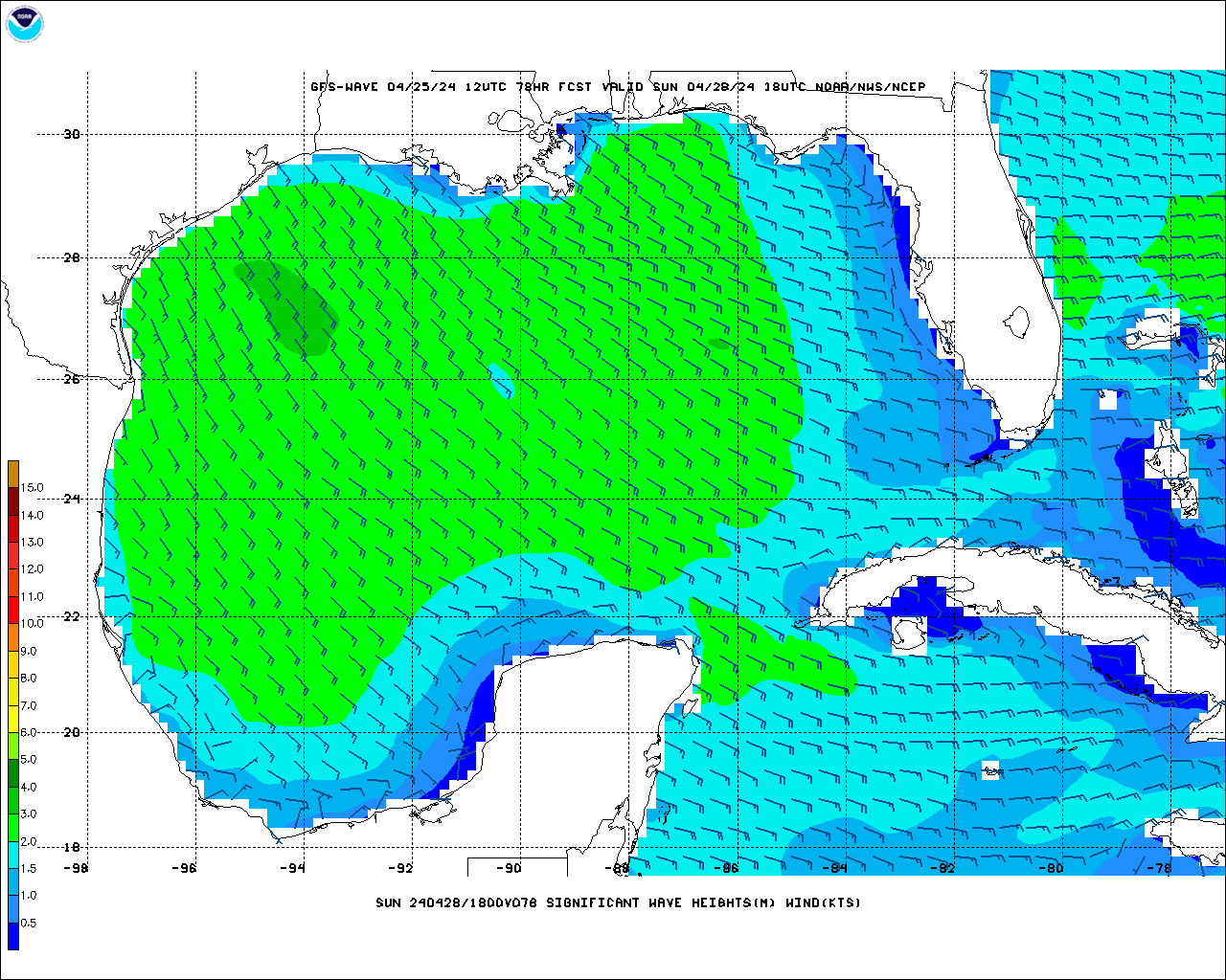
I used to go to Cocodrie, passing Houma, to catch a boat to near shore rigs. The vacation homes in Cocodrie are like Galveston, built on poles, but there are businesses not elevated. I used to go out of Fourchon a lot, Bayou Lafourche is protected from Mississippi flooding by a control structure, but any rain falling downstream, it is coming into the bayou, and also coming up from the bay. I'm not sure how wave heights correlate exactly to surge, especially as influenced by terrain, but 10 foot waves just offshore can't be good.
https://mag.ncep.noaa.gov/data/gfs-wave ... _wv_ht.gif]
Terrebonne parish has a pretty good flood control system now. Ida was the 1st to try it out. We did have minor flooding, but Ida hit more to our east. Our flood control system hasnt really been tested on a storm hitting to our west. I pray that it holds weight as desgned.
My house was destroyed in Ida but my heart will forever be to my homeland. Im in the process of rebuilding. Fortunately, construction hasnt started yet.
0 likes
::::::Danny & Juan '85, Andrew '92, Lili '02, Katrina & Rita '05, Gustav & Ike '08, Isaac '12, Ida 2021::::::
::::It's been a wild ride, but you just gotta love living on the gulf coast!::::
::::It's been a wild ride, but you just gotta love living on the gulf coast!::::
-
Sciencerocks
- Category 5
- Posts: 10181
- Age: 40
- Joined: Thu Jul 06, 2017 1:51 am

Re: ATL: INVEST 91L - Discussion
21N 94.7W
Looks like a high-helicity tower is forming a warm-core signature on IR
Thats the area that recon may have tagged a possible center as well.
Looks like a high-helicity tower is forming a warm-core signature on IR
Thats the area that recon may have tagged a possible center as well.
0 likes
Who is online
Users browsing this forum: No registered users and 37 guests