ATL: HELENE - Post-Tropical - Discussion
Moderator: S2k Moderators
-
Poonwalker
- Category 1

- Posts: 270
- Joined: Tue Sep 20, 2022 11:12 am
Re: ATL: INVEST 97L - Discussion
Flooding is likely in Tampa and Pinellas. The ground is still saturated for a lot of lower lying areas. Only hope is this thing moves as quickly as forecasted and stays well offshore. No east shift please.
2 likes
-
DunedinDave
- Category 1
- Posts: 269
- Joined: Fri Aug 25, 2023 10:31 am
Re: ATL: INVEST 97L - Discussion
The heavy convection is really blowing off to the East’s on satellite. If the center doesn’t go with the convention this may take a longer time than thought to organize. There’s hardly any clouds where the center is “supposed” to be.
1 likes

Re: ATL: INVEST 97L - Discussion
DunedinDave wrote:The heavy convection is really blowing off to the East’s on satellite. If the center doesn’t go with the convention this may take a longer time than thought to organize. There’s hardly any clouds where the center is “supposed” to be.
This is in line with model expectations. The GFS has this convection getting blown off as new cloud tops develop over the center this morning.
1 likes
Kendall -> SLO -> PBC
Memorable Storms: Katrina (for its Florida landfall...) Wilma Matthew Irma
Memorable Storms: Katrina (for its Florida landfall...) Wilma Matthew Irma
-
Ian2401
- Category 1
- Posts: 321
- Joined: Thu Sep 14, 2017 5:55 pm
- Location: Tallahassee, Florida
- Contact:
Re: ATL: INVEST 97L - Discussion
new convection firing off the coast. old convection waning a touch as it gets blasted to the east. dont see any reformation occurring with that blob of convection at least. could've happened earlier, but won't know till morning light / recon's arrival. getting some sleep now
0 likes
B.S. Meteorology from Florida State '24 // Current M.S. Meteorology student at Florida State
Research Interests: Rapid Intensification, TC Climatology, TC Modeling
Consult the NHC for official information
Research Interests: Rapid Intensification, TC Climatology, TC Modeling
Consult the NHC for official information
-
ConvergenceZone
.gif)
- Category 5

- Posts: 5241
- Joined: Fri Jul 29, 2005 1:40 am
- Location: Northern California
Re: ATL: INVEST 97L - Discussion
I noticed that the talk about the Shear in the gulf has dropped off significantly compared to a few days ago, does that mean that shear in the gulf is no longer expected?
1 likes
-
Blown Away

- S2K Supporter

- Posts: 10253
- Joined: Wed May 26, 2004 6:17 am
Re: ATL: INVEST 97L - Discussion
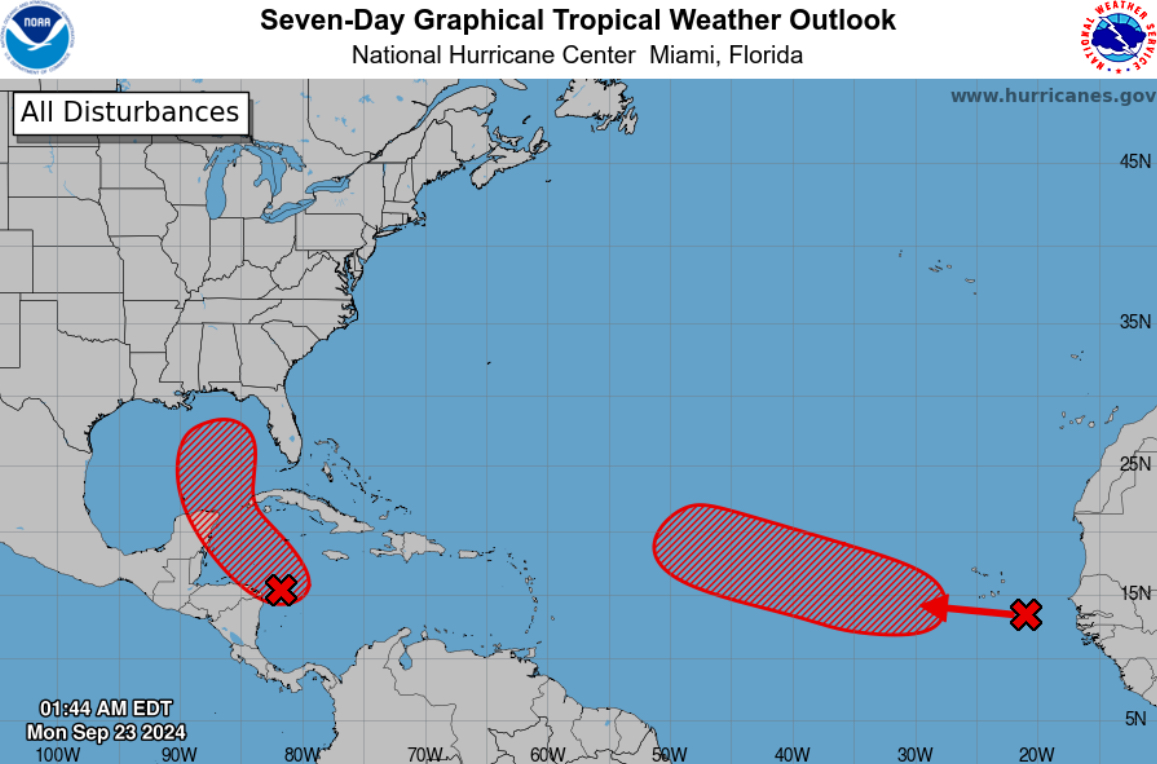
NHC 2am, development area extended E of 80W now, possibly considering the LLC to form a little farther E?
3 likes
Hurricane Eye Experience: David 79, Irene 99, Frances 04, Jeanne 04, Wilma 05… Hurricane Brush Experience: Andrew 92, Erin 95, Floyd 99, Matthew 16, Irma 17, Ian 22, Nicole 22…
-
HurryKane

- Category 5
- Posts: 1941
- Joined: Sun Sep 12, 2004 8:08 pm
- Location: Diamondhead, Mississippi
Re: ATL: INVEST 97L - Discussion
KC7NEC wrote:Heading to a mental health program conference in St. Pete Beach starting Tuesday for ten days. While I’ve been a weather enthusiast for as long as I can remember and have a good sense of what to expect, I get the feeling that many attendees might have no idea that we could be in the path of a major hurricane by Thursday night. It’s such a tricky situation since we won’t have a solid handle on things until a few days out. I’m hoping the event organizers are already considering this and will send out a preparedness email soon. I’m not too worried yet, but I can see how some attendees might run into trouble if they arrive unaware of what could be coming. Depending on tomorrow’s early model runs, I’ll probably email the organizers with some thoughts and info.
While any event organizer worth their salt would already be watching the situation and would have plans at the ready to contact attendees/cancel, it couldn’t hurt for you to contact them directly with your concerns about how things are developing on the off that chance they are not weather savvy—they may have a general contact email on the conference website. Good luck and stay safe.
1 likes
-
Blown Away
- S2K Supporter
- Posts: 10253
- Joined: Wed May 26, 2004 6:17 am
Re: ATL: INVEST 97L - Discussion
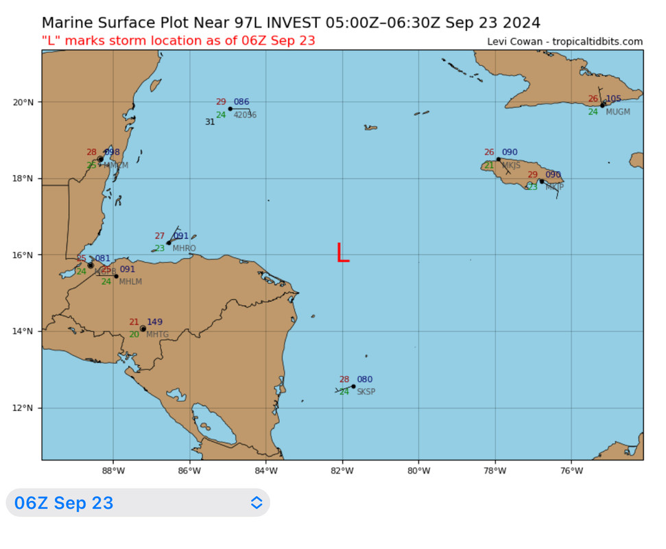
06z
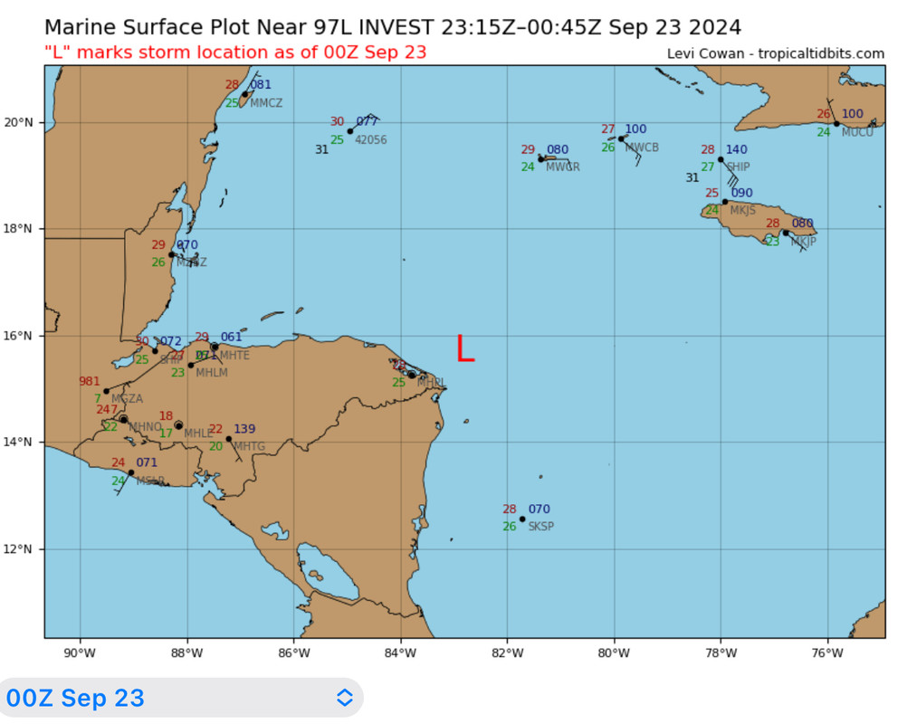
00z
06z estimated “L” repositioned @60 miles E of 00z… I still think @degree E of that is where the LLC will setup…
0 likes
Hurricane Eye Experience: David 79, Irene 99, Frances 04, Jeanne 04, Wilma 05… Hurricane Brush Experience: Andrew 92, Erin 95, Floyd 99, Matthew 16, Irma 17, Ian 22, Nicole 22…
-
Keldeo1997
- Category 2

- Posts: 688
- Joined: Fri Oct 11, 2019 11:35 pm
Re: ATL: INVEST 97L - Discussion

Don't have anything now but there is suspicious area to the NE around 17N 81W
0 likes
Re: ATL: INVEST 97L - Discussion
Looks like about 81.5W 17N. Going through higher shear

42057 SE Jamacia is starting to drop

42057 SE Jamacia is starting to drop
1 likes

Re: ATL: INVEST 97L - Discussion
Keldeo1997 wrote:https://cdn.discordapp.com/attachments/1157676956674949152/1287675300855156787/remix-42de6807-ad19-4369-8431-6797ce2a47cd.png?ex=66f26893&is=66f11713&hm=1a3a282bf6f0885d71211e1ece65321ef5b2d8e77425d936f384430156923f8a&
Don't have anything now but there is suspicious area to the NE around 17N 81W
While this will be bad, if it were to develop further east the odds of a significant impact for Tampa go up.
While it looks like we may avoid the infamous I name, Helene is my late great grandmom's name and she is entombed in Clearwater...so there is that. She always had a fear of water and us kids drowning after it rains, of course she was not all there.
3 likes
-
tropicwatch

- Category 5
- Posts: 3426
- Age: 62
- Joined: Sat Jun 02, 2007 10:01 am
- Location: Panama City Florida
- Contact:
Re: ATL: INVEST 97L - Discussion
Buoy 42057 close to the circulation reporting 1004.7mb.
1 likes
Tropicwatch
Agnes 72', Eloise 75, Elena 85', Kate 85', Charley 86', Florence 88', Beryl 94', Dean 95', Erin 95', Opal 95', Earl 98', Georges 98', Ivan 2004', Arlene 2005', Dennis 2005', Ida 2009' Debby 2012' Irma 2017' Michael 2018'
Agnes 72', Eloise 75, Elena 85', Kate 85', Charley 86', Florence 88', Beryl 94', Dean 95', Erin 95', Opal 95', Earl 98', Georges 98', Ivan 2004', Arlene 2005', Dennis 2005', Ida 2009' Debby 2012' Irma 2017' Michael 2018'

Re: ATL: INVEST 97L - Discussion
tropicwatch wrote:Buoy 42057 close to the circulation reporting 1004.7mb.
Another buoy right next to it now down to 1004.5 mbar. Based on other measurements in the region, background pressure seems to be about 1008 - 1009 mbar.
2 likes
Re: ATL: INVEST 97L - Discussion
kevin wrote:tropicwatch wrote:Buoy 42057 close to the circulation reporting 1004.7mb.
Another buoy right next to it now down to 1004.5 mbar. Based on other measurements in the region, background pressure seems to be about 1008 - 1009 mbar.
That seems low enough to support a TD just need a west wind
0 likes
Re: ATL: INVEST 97L - Discussion
An ASCAT pass from about 6 - 7 hours ago already showed some 25 - 30 kt barbs and wasn't a direct hit. If hurricane models are to be believed this might already be a TD and is only hours away from TS status. A blend of hurricane models says that recon should find a 997 mb / 44 kt TS at 18z when it arrives today.
2 likes
Re: ATL: INVEST 97L - Discussion
kevin wrote:An ASCAT pass from about 6 - 7 hours ago already showed some 25 - 30 kt barbs and wasn't a direct hit. If hurricane models are to be believed this might already be a TD and is only hours away from TS status. A blend of hurricane models says that recon should find a 997 mb / 44 kt TS at 18z when it arrives today.
Seems reasonable. This close out from landfall, you'd think NHC would pull the trigger prior to recon.
0 likes


Re: ATL: INVEST 97L - Discussion
kevin wrote:An ASCAT pass from about 6 - 7 hours ago already showed some 25 - 30 kt barbs and wasn't a direct hit. If hurricane models are to be believed this might already be a TD and is only hours away from TS status. A blend of hurricane models says that recon should find a 997 mb / 44 kt TS at 18z when it arrives today.
Buoy 42057 bottomed out at 1004.3 mb with a wind still from the east not ESE.
Mid level circulation is clearly near there as well ~81w.
With the wind out of the east at the surface, the center must be a little south of 17N.
1 likes
-
Hurricane Mike
- Category 2
- Posts: 675
- Joined: Tue Apr 10, 2018 7:44 am
Re: ATL: INVEST 97L - Discussion
5am Video Update on 97L
https://www.youtube.com/watch?v=fkIgd2lLv7s
https://www.youtube.com/watch?v=fkIgd2lLv7s
0 likes
-
Keldeo1997
- Category 2
- Posts: 688
- Joined: Fri Oct 11, 2019 11:35 pm
Re: ATL: INVEST 97L - Discussion

This could ugly with the storm going over the whole South to north end of the loop current. Really worried about ERI there.
2 likes
Who is online
Users browsing this forum: No registered users and 35 guests