EPAC: JOHN - Remnants - Discussion
Moderator: S2k Moderators
-
Kingarabian

- S2K Supporter

- Posts: 16345
- Joined: Sat Aug 08, 2009 3:06 am
- Location: Honolulu, Hawaii
Re: EPAC: JOHN - Tropical Storm - Discussion
The rate this thing likes to intensify at is pretty crazy.
4 likes
RIP Kobe Bryant

Re: EPAC: JOHN - Tropical Storm - Discussion
Incredible! I had to re-read the date. I thought they were talking about the first landfall.
1 likes
-
SconnieCane
- Category 5

- Posts: 1013
- Joined: Thu Aug 02, 2018 5:29 pm
- Location: Madison, WI
Re: EPAC: JOHN - Tropical Storm - Discussion
Might have happened in the WPAC or IO when I wasn't paying attention, but in the Atlantic or EPAC I don't know of any prior situation in which a TC made landfall on a mainland (large continent) landmass, was reduced to a remnant low, moved offshore, regenerated and made another landfall on that same landmass as a hurricane. A few have moved offshore and regenerated (Ivan, Harvey) but their second landfalls were as weak TS's.
1 likes
-
AJC3

- Admin

- Posts: 4153
- Age: 62
- Joined: Tue Aug 31, 2004 7:04 pm
- Location: Ballston Spa, New York
- Contact:
Re: EPAC: JOHN - Tropical Storm - Discussion
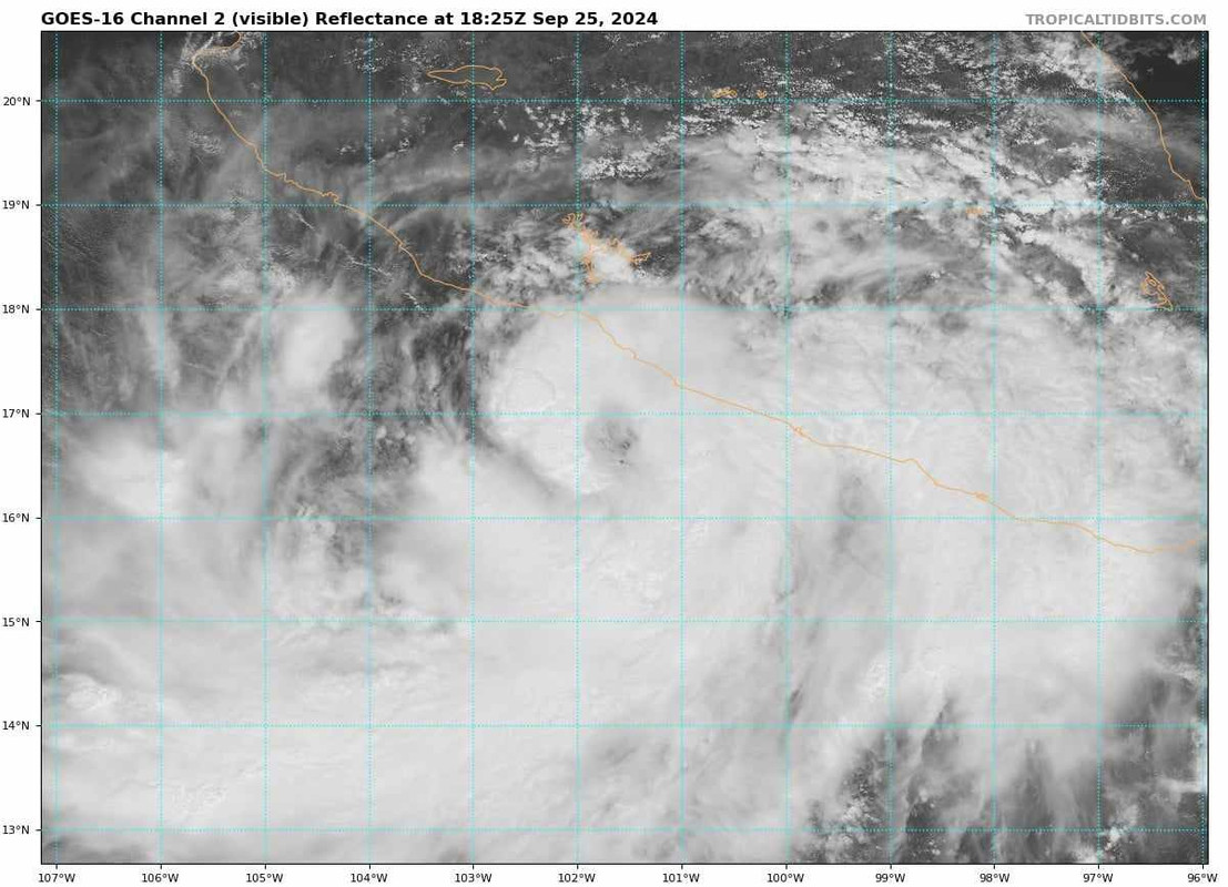
Tropical Storm John Advisory Number 12
NWS National Hurricane Center Miami FL EP102024
300 PM CST Wed Sep 25 2024
...JOHN EXPECTED TO BECOME A HURRICANE...
...HURRICANE WARNING ISSUED FOR SOUTHWESTERN MEXICO...
SUMMARY OF 300 PM CST...2100 UTC...INFORMATION
----------------------------------------------
LOCATION...16.8N 101.5W
ABOUT 105 MI...170 KM W OF ACAPULCO MEXICO
ABOUT 60 MI...100 KM S OF ZIHUATANEJO MEXICO
MAXIMUM SUSTAINED WINDS...50 MPH...85 KM/H
PRESENT MOVEMENT...N OR 355 DEGREES AT 3 MPH...6 KM/H
MINIMUM CENTRAL PRESSURE...996 MB...29.42 INCHES
WATCHES AND WARNINGS
--------------------
CHANGES WITH THIS ADVISORY:
The government of Mexico has issued a Hurricane Warning for the
coast of Mexico from Tecpan de Galeana to Lazaro Cardenas.
The government of Mexico has issued a Hurricane Watch for
the coast of Mexico from west of Lazaro Cardenas to Punta San Telmo.
The government of Mexico has issued a Tropical Storm Warning for
the coast of Mexico from west of Lazaro Cardenas to Punta San Telmo.
SUMMARY OF WATCHES AND WARNINGS IN EFFECT:
A Hurricane Warning is in effect for...
* Tecpan de Galeana to Lazaro Cardenas
A Hurricane Watch is in effect for...
* Acapulco to Tecpan de Galeana
* Lazaro Cardenas to Punta San Telmo
A Tropical Storm Warning is in effect for...
* Punta Maldonado to Acapulco
* Lazaro Cardenas to Punta San Telmo
For storm information specific to your area, please monitor
products issued by your national meteorological service.
DISCUSSION AND OUTLOOK
----------------------
At 300 PM CST (2100 UTC), the center of Tropical Storm John was
located near latitude 16.8 North, longitude 101.5 West. John is
moving toward the north near 3 mph (6 km/h). This motion should
continue for the next day or so, followed by a gradual turn to the
west-northwest on Friday. On the forecast track, the center of John
is forecast to approach the southwestern coast of Mexico on early
Thursday and be inland on Friday.
Maximum sustained winds have increased to near 50 mph (85 km/h) with
higher gusts. John is forecast to strengthen as it approaches the
coast of southern Mexico on Thursday.
Tropical-storm-force winds extend outward up to 150 miles (240 km)
from the center.
The estimated minimum central pressure is 996 mb (29.42 inches).
HAZARDS AFFECTING LAND
----------------------
RAINFALL: Through Friday, Tropical Storm John is expected to produce
additional rainfall amounts of 10 to 20 inches with isolated totals
around 30 inches across portions of the Mexican States of Guerrero,
Oaxaca and Michoacan.
For a complete depiction of forecast rainfall associated with John,
please see the National Weather Service Storm Total Rainfall
Graphic, available at hurricanes.gov/graphics_ep5.shtml?rainqpf
STORM SURGE: A dangerous storm surge is expected to produce coastal
flooding near and to the east of where the center makes landfall.
Near the coast, the surge will be accompanied by large and
destructive waves.
WIND: Hurricane conditions are expected along the coast within the
hurricane warning area Thursday. Winds are expected to first reach
tropical storm strength as early as tonight, making outside
preparations difficult or dangerous. Preparations to protect life
and property should be rushed to completion.
Tropical storm conditions are expected to first reach the coast
within the tropical storm warning area as early as tonight.
SURF: Swells associated with John are forecast to continue to
affect the coast of southern Mexico through the week, with the
potential for dangerous surf and rip currents. Please see local
statements for more information.
NEXT ADVISORY
-------------
Next intermediate advisory at 600 PM CST.
Next complete advisory at 900 PM CST.
$$
Tropical Storm John Discussion Number 12
NWS National Hurricane Center Miami FL EP102024
300 PM CST Wed Sep 25 2024
John is becoming more organized this afternoon. Satellite imagery
has shown deep bursts of convection forming near the center with
curved banding around the majority of the circulation. Subjective
Dvorak from TAFB and SAB were 3.5/55 kt and 2.5/35 kt, respectively,
and the initial intensity for this advisory is set to 45 kt to
represent a blend of these estimates. An Air Force Hurricane
Reconnaissance aircraft is en route to investigate John and gather
more information about the intensity, location, and structure. The
tropical-storm-force winds in the southeast quadrant have been
adjusted outward significantly based on an earlier partial ASCAT
pass.
Little has changed in the intensity forecast reasoning. Oceanic and
atmospheric conditions are conducive for further intensification, as
long as the storm remains over water. SHIPS-RII, a rapid
intensification indicator, shows about a 70 percent chance of rapid
intensification in the next 24 hours. The official intensity
forecast now shows John becoming a hurricane in 24 hours as it nears
the coast of southwestern Mexico. This forecast is near the top of
the guidance, closest to HCCA, but could still be conservative.
John is moving with an estimated motion of 355/3 kt. The track
forecast is rather uncertain. Model guidance has shifted westward,
and is showing John either nearly stationary or slowly following the
coastline northwestward. This motion seems to depend on the
strength of the ridge to the north-northwest, which is centered over
the southwestern United States. However, the current motion
suggests John should move closer to the coast with the center
likely to move inland on Thursday afternoon or evening, though
this could occur sooner. Future adjustments to the track forecast
may be necessary, and there remains a large spread in the aids.
A Hurricane Warning has been issued by the government of Mexico for
portions of the coast of southwestern Mexico, and interests there
should closely monitor future forecasts for updates. The Tropical
Storm Warning and Hurricane Watch have also been extended westward.
KEY MESSAGES:
1. Tropical Storm John will bring additional very heavy rainfall to
coastal portions of southwest Mexico through Friday. The additional
rainfall totals will be falling across areas that have received very
heavy rainfall amounts over the past few days. This heavy rainfall
will likely cause significant and catastrophic life-threatening
flash flooding and mudslides to the Mexican States of Guerrero,
Oaxaca and Michoacan.
2. John is forecast to strengthen to a hurricane before landfall,
and a Hurricane Warning has been issued for a portion of the
coastline of southwestern Mexico, where tropical storm conditions
could begin later today. The Tropical Storm Warning and Hurricane
Watch have also been extended westward.
FORECAST POSITIONS AND MAX WINDS
INIT 25/2100Z 16.8N 101.5W 45 KT 50 MPH
12H 26/0600Z 17.1N 101.5W 60 KT 70 MPH
24H 26/1800Z 17.5N 101.5W 65 KT 75 MPH
36H 27/0600Z 18.0N 101.6W 40 KT 45 MPH...INLAND
48H 27/1800Z 18.2N 102.1W 25 KT 30 MPH...INLAND
60H 28/0600Z...DISSIPATED
$$
1 likes
-
Category5Kaiju

- Category 5
- Posts: 4330
- Joined: Thu Dec 24, 2020 12:45 pm
- Location: Seattle and Phoenix
Re: EPAC: JOHN - Tropical Storm - Discussion
Honestly the best analog I could think of, in a sense, is Cyclone Freddy from last year, where it just meandered around the Mozambique Channel and intensified on multiple occasions before making landfall.
1 likes
Unless explicitly stated, all info in my posts is based on my own opinions and observations. Tropical storms and hurricanes can be extremely dangerous. Refer to an accredited weather research agency or meteorologist if you need to make serious decisions regarding an approaching storm.

-
zeehag
- Tropical Storm

- Posts: 181
- Age: 77
- Joined: Sun Jul 17, 2011 9:49 pm
- Location: mazatlan,sinaloa, mexico, fixing patricia's mess.
- Contact:
EPAC: JOHN - Recon
the humans and critters residing in zihuatenejo are readying for their drunken storm named john. the storm revived and is headed straight for a friend's home. they are expecting flooding, runoff from hell, and downpours beyond words. she has done much to prepare her new found home city for this. john is still 138 or less miles from landfall, and has folks a shade nervous. thankfully those of us who are water babies--she is a crew for a schooner, (we have similar backgrounds in being water babies and good sailors) have some knowledge of surviving these some better than the locals who have not seen many in their lives.
please hold good thoughts for zihuat and surrounding areas.
here is hoping it remains a ts.
please hold good thoughts for zihuat and surrounding areas.
here is hoping it remains a ts.
1 likes
-
Kingarabian
- S2K Supporter
- Posts: 16345
- Joined: Sat Aug 08, 2009 3:06 am
- Location: Honolulu, Hawaii
Re: EPAC: JOHN - Tropical Storm - Discussion
Looks like there's enough to strengthen it to 50-55kts .
0 likes
RIP Kobe Bryant
-
cycloneye

- Admin
- Posts: 149261
- Age: 69
- Joined: Thu Oct 10, 2002 10:54 am
- Location: San Juan, Puerto Rico
Re: EPAC: JOHN - Tropical Storm - Discussion
BULLETIN
Tropical Storm John Intermediate Advisory Number 12A
NWS National Hurricane Center Miami FL EP102024
600 PM CST Wed Sep 25 2024
...JOHN CONTINUES TO STRENGTHEN...
...THREAT OF CATASTROPHIC LIFE-THREATENING FLASH FLOODING AND
MUDSLIDES CONTINUES OVER PORTIONS OF SOUTHERN MEXICO...
SUMMARY OF 600 PM CST...0000 UTC...INFORMATION
----------------------------------------------
LOCATION...16.9N 101.8W
ABOUT 125 MI...200 KM W OF ACAPULCO MEXICO
ABOUT 55 MI...90 KM SSW OF ZIHUATANEJO MEXICO
MAXIMUM SUSTAINED WINDS...60 MPH...95 KM/H
PRESENT MOVEMENT...NNW OR 340 DEGREES AT 5 MPH...7 KM/H
MINIMUM CENTRAL PRESSURE...984 MB...29.06 INCHES
0 likes
Visit the Caribbean-Central America Weather Thread where you can find at first post web cams,radars
and observations from Caribbean basin members Click Here
and observations from Caribbean basin members Click Here

Re: EPAC: JOHN - Tropical Storm - Discussion
I was surprised and confused when I saw on NHC this was still a thing and "strengthening"! I also can't think of an analogue for it, insanity. Catastrophic flooding possible nearly at the same time in 2 diff basins and countries. Also why wasn't John retired back in '94? I still harken back to John of 06 too.
4 likes
-
Kingarabian
- S2K Supporter
- Posts: 16345
- Joined: Sat Aug 08, 2009 3:06 am
- Location: Honolulu, Hawaii
Re: EPAC: JOHN - Tropical Storm - Discussion
It's tilted a bit. LLC is east of the MLC.
0 likes
RIP Kobe Bryant
-
cycloneye
- Admin
- Posts: 149261
- Age: 69
- Joined: Thu Oct 10, 2002 10:54 am
- Location: San Juan, Puerto Rico
Re: EPAC: JOHN - Tropical Storm - Discussion
BULLETIN
Tropical Storm John Advisory Number 13
NWS National Hurricane Center Miami FL EP102024
900 PM CST Wed Sep 25 2024
...HURRICANE WARNING EXTENDED WESTWARD...
...THREAT OF CATASTROPHIC LIFE-THREATENING FLASH FLOODING AND
MUDSLIDES CONTINUES OVER PORTIONS OF SOUTHERN MEXICO...
SUMMARY OF 900 PM CST...0300 UTC...INFORMATION
----------------------------------------------
LOCATION...17.0N 102.1W
ABOUT 70 MI...110 KM S OF LAZARO CARDENAS MEXICO
ABOUT 60 MI...95 KM SW OF ZIHUATANEJO MEXICO
MAXIMUM SUSTAINED WINDS...65 MPH...100 KM/H
PRESENT MOVEMENT...NW OR 325 DEGREES AT 5 MPH...7 KM/H
MINIMUM CENTRAL PRESSURE...984 MB...29.06 INCHES
Tropical Storm John Discussion Number 13
NWS National Hurricane Center Miami FL EP102024
900 PM CST Wed Sep 25 2024
An Air Force Reserve Hurricane Hunter Aircraft just finished its
investigation of Hurricane John and found that the central pressure
has dropped to 984 mb. Dropsonde data and SFMR data support an
intensity of 55 kt, which is also the average of the latest TAFB
and SAB intensity estimates. Satellite imagery shows a very large
area of very cold cloud tops. Based on the available data, the
initial intensity is increased to 55 kt.
Based on fixes from the Air Force plane, the initial motion is
estimated to be northwestward, or 325/4 kt. The model guidance has
made a big shift to the west on this cycle, which makes sense since
John has been moving significantly to the west of the previous NHC
forecast track. The new NHC track forecast has been shifted well
to the west, and currently lies slightly to the east of the latest
track consensus aids. The westward shift to the track has
necessitated the Hurricane Warnings to be shifted farther west
along the coast of Mexico. The new forecast shows landfall
occurring about 40 to 50 miles farther to the west compared to the
previous official forecast, with the forecast landfall now well to
the west of Lazaro Cardenas later Thursday night. It should be
noted that there is still quite a bit of uncertainty in the track
forecast.
Hurricane John is currently located over 31C sea-surface
temperatures, which is extremely warm. The hurricane is also in a
moist environment and appears to also have a favorable upper-level
wind environment. Both the GFS-SHIPS and the ECMWF-SHIPS
Rapid-Intensity-Index shows a very high chance of rapid
intensification over the next 24 hours. The new NHC intensity
forecast has been increased significantly from the previous
official forecast, and lies near the high end of the latest
intensity guidance suite. Given the extremely favorable
environmental conditions, it wouldn't be surprising if further
increases to the intensity forecast are needed on subsequent
forecasts.
Although this forecast shows dissipation by hour 60, there is a
chance that John could survive a bit longer, moving
west-northwestward near the coast of Mexico.
It cannot be emphasized enough that catastrophic life-threatening
flash flooding and mudslides are expected to continue through the
end of the week for portions of the Mexican States of Guerrero,
Oaxaca and Michoacan.
KEY MESSAGES:
1. Tropical Storm John will bring additional very heavy rainfall to
coastal portions of southwest Mexico through Friday. The additional
rainfall totals will be falling across areas that have received very
heavy rainfall amounts over the past few days. This heavy rainfall
will likely cause significant and catastrophic life-threatening
flash flooding and mudslides to the Mexican States of Guerrero,
Oaxaca and Michoacan.
2. John is forecast to strengthen to a hurricane before landfall,
and the Hurricane Warning has been extended westward along the
coastline of southwestern Mexico, where tropical storm conditions
could begin within the next few hours. Tropical Storm Warnings are
also in effect for portions of the area.
FORECAST POSITIONS AND MAX WINDS
INIT 26/0300Z 17.0N 102.1W 55 KT 65 MPH
12H 26/1200Z 17.3N 102.3W 65 KT 75 MPH
24H 27/0000Z 17.7N 102.5W 80 KT 90 MPH
36H 27/1200Z 18.1N 102.7W 70 KT 80 MPH...INLAND
48H 28/0000Z 18.4N 103.2W 30 KT 35 MPH...INLAND
60H 28/1200Z...DISSIPATED
$$
Forecaster Hagen
2 likes
Visit the Caribbean-Central America Weather Thread where you can find at first post web cams,radars
and observations from Caribbean basin members Click Here
and observations from Caribbean basin members Click Here
-
InfernoFlameCat

- Category 5
- Posts: 2127
- Age: 22
- Joined: Mon Dec 14, 2020 10:52 am
- Location: Buford, GA
Re: EPAC: JOHN - Tropical Storm - Discussion
We could indeed see John hit 130mph just like that one poster predicted a while ago, just a little bit later lol!
0 likes
I am by no means a professional. DO NOT look at my forecasts for official information or make decisions based on what I post.
Goal: to become a registered expert over tropical and subtropical cyclones.
Goal: to become a registered expert over tropical and subtropical cyclones.
-
Category5Kaiju
- Category 5
- Posts: 4330
- Joined: Thu Dec 24, 2020 12:45 pm
- Location: Seattle and Phoenix
Re: EPAC: JOHN - Tropical Storm - Discussion
"Given the extremely favorable environmental conditions, it wouldn't be surprising if further increases to the intensity forecast are needed on subsequent forecasts."
That is a message you do not want to ever see.
That is a message you do not want to ever see.
3 likes
Unless explicitly stated, all info in my posts is based on my own opinions and observations. Tropical storms and hurricanes can be extremely dangerous. Refer to an accredited weather research agency or meteorologist if you need to make serious decisions regarding an approaching storm.

Re: EPAC: JOHN - Tropical Storm - Discussion
It's possible that we will have 3 EPAC major landfalls that were not seen 24-30 hours in advance within a year... And two of them are named John.
The posts in this forum are NOT official forecasts and should not be used as such. They are just the opinion of the poster and may or may not be backed by sound meteorological data. They are NOT endorsed by any professional institution or STORM2K. For official information, please refer to products from the NHC and NWS.
3 likes
TC naming lists: retirements and intensity
Most aggressive Advisory #1's in North Atlantic (cr. kevin for starting the list)
Most aggressive Advisory #1's in North Atlantic (cr. kevin for starting the list)


-
cycloneye
- Admin
- Posts: 149261
- Age: 69
- Joined: Thu Oct 10, 2002 10:54 am
- Location: San Juan, Puerto Rico
Re: EPAC: JOHN - Tropical Storm - Discussion
Tropical Storm John Discussion Number 14
NWS National Hurricane Center Miami FL EP102024
300 AM CST Thu Sep 26 2024
Recent TROPICS/TMS and SSMIS microwave passes indicated
an improved inner core with a 70 percent closed small eye feature.
The UW-CIMSS objective intensity guidance ranges from 56 to 65 kt,
and the latest SATCON analysis indicated an intensity of 61 kt. The
subjective satellite estimates from TAFB and SAB are 65 and 55 kt,
respectively. The initial intensity is set at 60 kt using a blend
of these data.
The ocean sea surface temperatures are very warm, and the shear is
low, and there is ample moisture in the low to mid-portions of the
atmosphere for John to quickly strengthen before the cyclone moves
over the coast on Friday. The UW-CIMSS AI RI index and the SHIPS
statistical-dynamical RI model both continue to show increasing
chances of John quickly strengthening during the next 24 hrs and
the NHC intensity forecast follows suit and shows a peak of 85 kt
before landfall.
The initial motion is estimated to be west-northwestward, or
285/3 kt and is being steered by a mid-tropospheric ridge centered
over Northern Mexico. John should continue in this general motion
is expected to continue today, followed by a gradual turn to the
northwest by this evening. On the forecast track, the center of
John is forecast to approach and move along the coast of
southwestern Mexico or just inland on Friday. The official track
forecast is adjusted to a little to the left of the previous one and
follows a compromise of the skilled HCCA consensus model and the
ECMWF global model, which has been performing the best with this
system.
The wind radii have been adjusted for this advisory, and was based
on a 0426 UTC METOP-C scatterometer overpass.
It cannot be emphasized enough that catastrophic life-threatening
flash flooding and mudslides are expected to continue through the
end of the week for portions of the Mexican States of Guerrero,
Oaxaca and Michoacan.
KEY MESSAGES:
1. Tropical Storm John will bring additional very heavy rainfall to
coastal portions of southwest Mexico through Friday. The additional
rainfall totals will be falling across areas that have received very
heavy rainfall amounts over the past few days. This heavy rainfall
will likely cause significant and catastrophic life-threatening
flash flooding and mudslides to the Mexican States of Guerrero,
Oaxaca and Michoacan.
2. John is forecast to strengthen to a hurricane before landfall,
and a Hurricane Warning is in effect along the coastline of
southwestern Mexico, where tropical storm conditions could begin
during the next few hours. Tropical Storm Warnings are also
in effect for portions of the area and has been extended westward
to Manzanillo.
FORECAST POSITIONS AND MAX WINDS
INIT 26/0900Z 17.1N 102.5W 60 KT 70 MPH
12H 26/1800Z 17.2N 102.6W 75 KT 85 MPH
24H 27/0600Z 17.8N 103.0W 85 KT 100 MPH
36H 27/1800Z 18.8N 103.6W 45 KT 50 MPH
48H 28/0600Z 19.7N 104.7W 30 KT 35 MPH
60H 28/1800Z 20.2N 106.2W 25 KT 30 MPH...POST-TROP/REMNT LOW
72H 29/0600Z...DISSIPATED
$$
Forecaster Roberts
0 likes
Visit the Caribbean-Central America Weather Thread where you can find at first post web cams,radars
and observations from Caribbean basin members Click Here
and observations from Caribbean basin members Click Here
-
cycloneye
- Admin
- Posts: 149261
- Age: 69
- Joined: Thu Oct 10, 2002 10:54 am
- Location: San Juan, Puerto Rico
Re: EPAC: JOHN - Hurricane - Discussion
BULLETIN
Hurricane John Intermediate Advisory Number 14A
NWS National Hurricane Center Miami FL EP102024
600 AM CST Thu Sep 26 2024
...JOHN BECOMES A HURRICANE ONCE AGAIN...
...CATASTROPHIC LIFE-THREATENING FLASH FLOODING AND MUDSLIDES
CONTINUE OVER PORTIONS OF SOUTHERN MEXICO...
SUMMARY OF 600 AM CST...1200 UTC...INFORMATION
----------------------------------------------
LOCATION...17.3N 102.6W
ABOUT 55 MI...90 KM SSW OF LAZARO CARDENAS MEXICO
ABOUT 70 MI...115 KM WSW OF ZIHUATANEJO MEXICO
MAXIMUM SUSTAINED WINDS...75 MPH...120 KM/H
PRESENT MOVEMENT...WNW OR 285 DEGREES AT 4 MPH...7 KM/H
MINIMUM CENTRAL PRESSURE...979 MB...28.91 INCHES
0 likes
Visit the Caribbean-Central America Weather Thread where you can find at first post web cams,radars
and observations from Caribbean basin members Click Here
and observations from Caribbean basin members Click Here

Re: EPAC: JOHN - Hurricane - Discussion
Here we go again... Has something like this ever happened before aka a TC regenerating and making landfall as a rapidly intensifying hurricane twice?
3 likes
-
WaveBreaking

- Category 2

- Posts: 717
- Joined: Sun Jun 30, 2024 11:33 am
- Location: US
Re: EPAC: JOHN - Hurricane - Discussion
kevin wrote:Here we go again... Has something like this ever happened before aka a TC regenerating and making landfall as a rapidly intensifying hurricane twice?
Cyclone Freddy did that to Mozambique iirc.
1 likes
I am NOT a professional meteorologist, so take all of my posts with a grain of salt. My opinions are mine and mine alone.
Who is online
Users browsing this forum: No registered users and 35 guests