ATL: MILTON - Post-Tropical - Discussion

Moderator: S2k Moderators

Message
Author
User avatar
Travorum
Category 1
Category 1
Posts: 406
Joined: Tue Sep 05, 2023 9:36 am
Location: Dunedin, FL

Re: ATL: MILTON - Hurricane - Discussion

#1501 Postby Travorum » Mon Oct 07, 2024 9:51 am

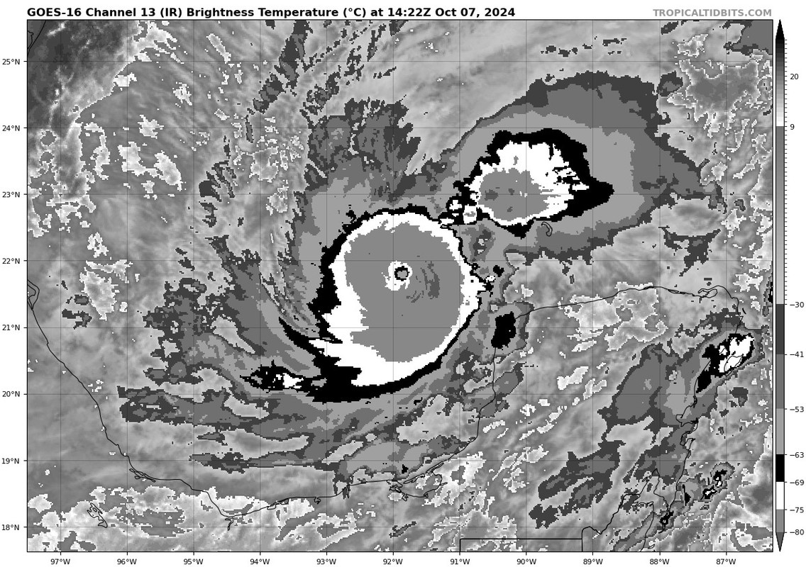
Kingarabian wrote:Breaking constraints, this would be a T7.0 on Dvorak.

https://i.postimg.cc/T1n1cJK1/Untitled.jpg

Need the eye to go WMG to get to Wilma/Patricia levels which so far its been having a hard time.


Indeed it would be, ADT raw T# is at 7.1:
UW - CIMSS
ADVANCED DVORAK TECHNIQUE
ADT-Version 9.1
Tropical Cyclone Intensity Algorithm

----- Current Analysis -----
Date : 07 OCT 2024 Time : 141020 UTC
Lat : 21:32:24 N Lon : 92:00:36 W


CI# /Pressure/ Vmax
5.5 / 955.5mb/102.0kt


Final T# Adj T# Raw T#
5.5 5.9 7.1

Estimated radius of max. wind based on IR :<10 km

Center Temp : -28.6C Cloud Region Temp : -76.5C
1 likes   

User avatar
MGC
S2K Supporter
S2K Supporter
Posts: 5899
Joined: Sun Mar 23, 2003 9:05 pm
Location: Pass Christian MS, or what is left.

Re: ATL: MILTON - Hurricane - Discussion

#1502 Postby MGC » Mon Oct 07, 2024 9:51 am

Milton on the way to Cat-5. Incredible intensification, beyond rapid. Lets see how long before Milton undergoes any eyewall replacement. Of course the wind field will expand which will cause the surge impacts to be extreme for the Florida coast....think Katrina or Rita situation. Yup, if you are living in a condo along the beach or home close to the beach I'd be packing up......MGC
7 likes   

tolakram
Admin
Admin
Posts: 20012
Age: 62
Joined: Sun Aug 27, 2006 8:23 pm
Location: Florence, KY (name is Mark)

Re: ATL: MILTON - Hurricane - Discussion

#1503 Postby tolakram » Mon Oct 07, 2024 9:51 am

saved loop
Image
8 likes   
M a r k
- - - - -
Join us in chat: Storm2K Chatroom Invite. Android and IOS apps also available.

The posts in this forum are NOT official forecasts and should not be used as such. Posts are NOT endorsed by any professional institution or STORM2K.org. For official information and forecasts, please refer to NHC and NWS products.

User avatar
CronkPSU
S2K Supporter
S2K Supporter
Posts: 2014
Joined: Sun Aug 07, 2005 10:44 pm
Location: Avalon Park, FL

Re: ATL: MILTON - Hurricane - Discussion

#1504 Postby CronkPSU » Mon Oct 07, 2024 9:53 am

ScottNAtlanta wrote:
Teban54 wrote:
Xyls wrote:
So I took a look through the Wikipedia list and there have been some mildly west-east tracks when there is a strong northerly component (Ian, Michael, 1924 Cuba) but as far as heading east if not south-east. Don't think there is any climatologically comparable storm. Lenny would be closest but against not in the same area and didn't reach Cat 5. May have to call this Wrong-Way Milton just like with Lenny lol.

Wrong Lane Milton rhymes better :lol: Or Left Lane Milton?

Only problem is that Milton is moving stage right not left


mixed up milton?
1 likes   
Just like Jon Snow..."I know nothing" except what I know, and most of what I know is gathered by the fine people of the NHC

User avatar
weeniepatrol
Category 5
Category 5
Posts: 1276
Joined: Sat Aug 22, 2020 5:30 pm
Location: WA State

Re: ATL: MILTON - Hurricane - Discussion

#1505 Postby weeniepatrol » Mon Oct 07, 2024 9:53 am

ORECAST VALID 08/0000Z 21.5N 90.4W
MAX WIND 145 KT...GUSTS 175 KT.

!!
3 likes   

Pasmorade
Tropical Storm
Tropical Storm
Posts: 141
Joined: Mon Jul 01, 2024 7:44 am
Location: Florida

Re: ATL: MILTON - Hurricane - Discussion

#1506 Postby Pasmorade » Mon Oct 07, 2024 9:54 am

Guess I just ate crow. The NHC just stated it's at 155mph for the 11am advisory...
4 likes   

User avatar
HurricaneAndre2008
Category 1
Category 1
Posts: 335
Age: 27
Joined: Wed Jul 31, 2019 9:51 pm
Contact:

Re: ATL: MILTON - Hurricane - Discussion

#1507 Postby HurricaneAndre2008 » Mon Oct 07, 2024 9:54 am

074
WTNT34 KNHC 071453
TCPAT4

BULLETIN
Hurricane Milton Advisory Number 10
NWS National Hurricane Center Miami FL AL142024
1000 AM CDT Mon Oct 07 2024

...MILTON CONTINUING TO RAPIDLY INTENSIFY..
...FORECAST TO BECOME A CATEGORY 5 HURRICANE...

SUMMARY OF 1000 AM CDT...1500 UTC...INFORMATION
-----------------------------------------------
LOCATION...21.7N 91.7W
ABOUT 130 MI...210 KM WNW OF PROGRESO MEXICO
ABOUT 720 MI...1160 KM SW OF TAMPA FLORIDA
MAXIMUM SUSTAINED WINDS...155 MPH...250 KM/H
PRESENT MOVEMENT...ESE OR 110 DEGREES AT 9 MPH...15 KM/H
MINIMUM CENTRAL PRESSURE...933 MB...27.55 INCHES
5 likes   
Cindy(2005), Katrina(2005), Rita(2005), Erin(2007), Isaac(2012)

User avatar
Category5Kaiju
Category 5
Category 5
Posts: 4104
Joined: Thu Dec 24, 2020 12:45 pm
Location: Seattle

Re: ATL: MILTON - Hurricane - Discussion

#1508 Postby Category5Kaiju » Mon Oct 07, 2024 9:55 am

It's official. Milton is more intense than Beryl.
10 likes   
Unless explicitly stated, all info in my posts is based on my own opinions and observations. Tropical storms and hurricanes can be extremely dangerous. Do not think you can beat Mother Nature. Refer to an accredited weather research agency or meteorologist if you need to make serious decisions regarding an approaching storm.

User avatar
Travorum
Category 1
Category 1
Posts: 406
Joined: Tue Sep 05, 2023 9:36 am
Location: Dunedin, FL

Re: ATL: MILTON - Hurricane - Discussion

#1509 Postby Travorum » Mon Oct 07, 2024 9:55 am

At 933mb Milton is now officially the deepest hurricane of 2024, beating out both Beryl and Kirk by 1mb.
7 likes   

User avatar
FLpanhandle91
Category 5
Category 5
Posts: 1033
Age: 34
Joined: Mon Sep 13, 2010 3:50 pm
Location: Fort Walton Beach, FL

Re: ATL: MILTON - Hurricane - Discussion

#1510 Postby FLpanhandle91 » Mon Oct 07, 2024 9:55 am

FORECAST VALID 08/0000Z 21.5N 90.4W
MAX WIND 145 KT...GUSTS 175 KT.
64 KT... 20NE 30SE 30SW 20NW.
50 KT... 40NE 45SE 45SW 40NW.
34 KT... 70NE 80SE 80SW 70NW.
3 likes   

User avatar
weeniepatrol
Category 5
Category 5
Posts: 1276
Joined: Sat Aug 22, 2020 5:30 pm
Location: WA State

Re: ATL: MILTON - Hurricane - Discussion

#1511 Postby weeniepatrol » Mon Oct 07, 2024 9:57 am

Milton's remarkable rapid intensification is continuing. Satellite
images show a small eye within the very cold central cloud cover,
and the eye is becoming better defined. Data from the Mexican
radar at Sabancuy show a small, closed eye with an intense eyewall
presentation. The Hurricane Hunter aircraft earlier reported a peak
flight-level wind of 146 kt, and dropsonde data show that the
pressure has fallen to around 933 mb, which is down about 22 mb in
4 hours. The initial wind speed is set to 135 kt, which is an
80-kt increase in 24 hours (only eclipsed by Wilma 2005 and Felix
2007 in our records).
5 likes   

User avatar
syfr
S2K Supporter
S2K Supporter
Posts: 170
Age: 106
Joined: Fri Oct 26, 2012 7:33 pm
Location: East Central NC

Re: ATL: MILTON - Hurricane - Discussion

#1512 Postby syfr » Mon Oct 07, 2024 9:57 am

CronkPSU wrote:
it's not...i use that site all the time cause i teach in polk but live in orlando...my normal drive time home is 55 minutes, it is 1 hour and 40 minutes right now...evacx traffic is definitely occuring already


Another plug for near "real time" traffic conditions would be for the Waze app (owned by Google) for your phone . It's as real time as it gets, and provides updated routings based on congestion/accidents etc.


(I promise not to plug this again, but it's incredibly useful for situations like this)
Last edited by syfr on Mon Oct 07, 2024 9:58 am, edited 1 time in total.
2 likes   
I'm not a meteorologist, I'm an electronics engineer. While I can probably fix your toaster oven, you're not going to learn about storms from me!

New Mexico had no hurricanes. Then I moved to NC right before Fran.....

SconnieCane
Category 4
Category 4
Posts: 998
Joined: Thu Aug 02, 2018 5:29 pm
Location: Madison, WI

Re: ATL: MILTON - Hurricane - Discussion

#1513 Postby SconnieCane » Mon Oct 07, 2024 9:58 am

tolakram wrote:saved loop
https://i.imgur.com/4f3twe8.gif


There's that stadium effect.
2 likes   

User avatar
aspen
Category 5
Category 5
Posts: 8819
Joined: Sat Oct 12, 2019 7:10 pm
Location: Connecticut, USA

Re: ATL: MILTON - Hurricane - Discussion

#1514 Postby aspen » Mon Oct 07, 2024 9:58 am

One final AF pass coming up, which should hit the max winds and be enough to upgrade Milton to a Cat 5.

The eye is finally starting to warm up on the latest frames too. Wonder how long before we get positive eye temps.
6 likes   
Irene '11 Sandy '12 Hermine '16 5/15/2018 Derecho Fay '20 Isaias '20 Elsa '21 Henri '21 Ida '21

I am only a meteorology enthusiast who knows a decent amount about tropical cyclones. Look to the professional mets, the NHC, or your local weather office for the best information.

User avatar
Xyls
Tropical Storm
Tropical Storm
Posts: 162
Joined: Thu Sep 07, 2023 3:48 pm
Location: New Brunswick, Canada

Re: ATL: MILTON - Hurricane - Discussion

#1515 Postby Xyls » Mon Oct 07, 2024 9:59 am

This thing is getting extremely close to the Yucatan. It may be close to push in a significant storm surge into some of the communities. Luckily, there aren't many on the north coast of the Yucatan but I would be extremely concerned if you are in Las Coloradas, San Felipe or Rio Lagartos as this goes by may be some significant surge depending on how close this gets.
1 likes   
Not a professional meteorologist. Please refer to NHC forecasts for official information/advice relating to tropical systems.

MEANINGLESS_NUMBERS
Category 1
Category 1
Posts: 332
Joined: Mon Nov 02, 2020 1:43 pm

Re: ATL: MILTON - Hurricane - Discussion

#1516 Postby MEANINGLESS_NUMBERS » Mon Oct 07, 2024 10:00 am

Cat 5 forecast. A rare thing.

INIT 07/1500Z 21.7N 91.7W 135 KT 155 MPH
12H 08/0000Z 21.5N 90.4W 145 KT 165 MPH
24H 08/1200Z 22.2N 88.3W 140 KT 160 MPH
36H 09/0000Z 23.6N 86.4W 135 KT 155 MPH
48H 09/1200Z 25.5N 84.7W 125 KT 145 MPH
60H 10/0000Z 27.7N 82.8W 110 KT 125 MPH
72H 10/1200Z 29.2N 80.1W 80 KT 90 MPH
96H 11/1200Z 30.8N 71.0W 55 KT 65 MPH...POST-TROP/EXTRATROP
120H 12/1200Z 31.0N 66.0W 45 KT 50 MPH...POST-TROP/EXTRATROP
4 likes   
Emily '87, Felix '95, Gert '99, Fabian '03, Humberto '19, Paulette '20, Teddy '20, Fiona '22, Lee '23, Ernesto '24

User avatar
WaveBreaking
Category 2
Category 2
Posts: 580
Joined: Sun Jun 30, 2024 11:33 am
Location: US

Re: ATL: MILTON - Hurricane - Discussion

#1517 Postby WaveBreaking » Mon Oct 07, 2024 10:01 am

Milton is about to pull off what Delta couldn’t and become a Category 5 :eek:
6 likes   
I am NOT a professional meteorologist, so take all of my posts with a grain of salt. My opinions are mine and mine alone.

Abdullah
Category 1
Category 1
Posts: 379
Joined: Sat Sep 08, 2018 4:28 pm
Location: Miramar, FL

Re: ATL: MILTON - Hurricane - Discussion

#1518 Postby Abdullah » Mon Oct 07, 2024 10:01 am

They moved the forecast track pretty far to the north, by twenty-five miles. Now it shows landfall at St. Pete Beach as a Cat 3 just after 8 PM Wednesday.
That would be the worst-case scenario for Tampa Bay.
2 likes   

User avatar
Zonacane
Category 1
Category 1
Posts: 361
Joined: Tue Aug 03, 2021 2:23 pm

Re: ATL: MILTON - Hurricane - Discussion

#1519 Postby Zonacane » Mon Oct 07, 2024 10:01 am

aspen wrote:One final AF pass coming up, which should hit the max winds and be enough to upgrade Milton to a Cat 5.

The eye is finally starting to warm up on the latest frames too. Wonder how long before we get positive eye temps.

I would imagine satellite is having a hard time resolving the small eye.
1 likes   

User avatar
kevin
Category 5
Category 5
Posts: 2587
Age: 26
Joined: Wed Aug 28, 2019 4:35 am

Re: ATL: MILTON - Hurricane - Discussion

#1520 Postby kevin » Mon Oct 07, 2024 10:02 am

NHC now has a 110 kt landfall directly into Tampa Bay. If there's anybody in that area still unsure what to do, please get to safety in time.

Image
4 likes   


Return to “2024”

Who is online

Users browsing this forum: No registered users and 10 guests