
ATL: MILTON - Post-Tropical - Discussion
Moderator: S2k Moderators
-
weeniepatrol

- Category 5

- Posts: 1339
- Joined: Sat Aug 22, 2020 5:30 pm
- Location: WA State

Re: ATL: MILTON - Hurricane - Discussion
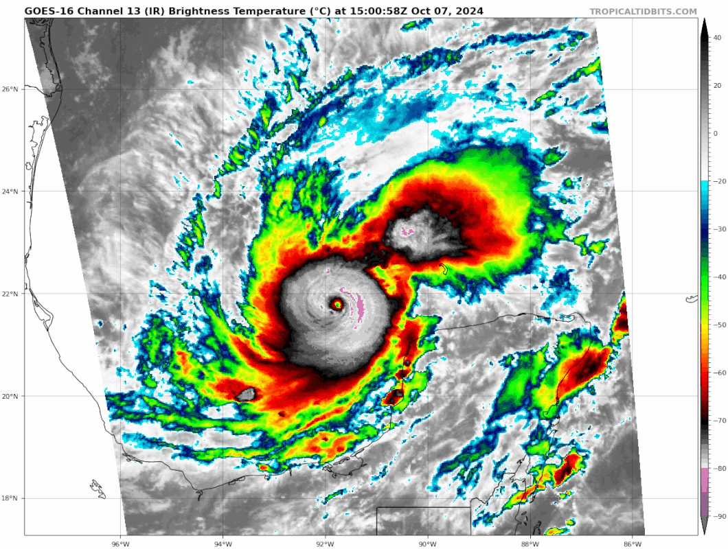
Eye continues to clear out. Milton's current appearance reminds me of Otis, but with the difference that Milton has way more time before landfall (and more water to push despite the expected weakening between now and then).
8 likes
TC naming lists: retirements and intensity
Most aggressive Advisory #1's in North Atlantic (cr. kevin for starting the list)
Most aggressive Advisory #1's in North Atlantic (cr. kevin for starting the list)

Re: ATL: MILTON - Hurricane - Discussion
aspen wrote:GCANE wrote:Milton is now under the influence of ionospheric heating with a moderate geomagnetic storm
https://solarham.com/globald.htm
https://solarham.com/kp.htm
Will this put a cap on Milton’s future intensification today by decreasing atmospheric lapse rates?
Actually, the opposite effect.
Ionospheric heating vertically raises the atmosphere below it.
This allows Milton's vort to expand vertically.
Conservation of angular momentum dictates Milton will spin faster
11 likes
-
chris_fit

- Category 5
- Posts: 3261
- Age: 43
- Joined: Wed Sep 10, 2003 11:58 pm
- Location: Tampa Bay Area, FL
Re: ATL: MILTON - Hurricane - Discussion
wxman57 wrote:I can't believe NHC didn't update that surge graphic to show 12-18 ft into Tampa Bay. It'll be about 12ft on the coast, but much higher into the Bay if it tracks across the northern part of TB.
What's your track Sir? You thinking North, direct, or South of TB? (Asking from Bradenton Area - away from the surge)
0 likes
-
Category5Kaiju

- Category 5
- Posts: 4322
- Joined: Thu Dec 24, 2020 12:45 pm
- Location: Seattle and Phoenix
Re: ATL: MILTON - Hurricane - Discussion
Oof, that island just to the north of the Yucatan looks like it's going to take a whacking.
1 likes
Unless explicitly stated, all info in my posts is based on my own opinions and observations. Tropical storms and hurricanes can be extremely dangerous. Refer to an accredited weather research agency or meteorologist if you need to make serious decisions regarding an approaching storm.


Re: ATL: MILTON - Hurricane - Discussion
Anyone else catching those pink cloud tops that are swirling in the blob? Looks like a second eye starting. Craziness.
0 likes
Not a professional meteorologist. Please refer to NHC forecasts for official information/advice relating to tropical systems.

Re: ATL: MILTON - Hurricane - Discussion
Interesting they circled around prior to penetrating the eyewall.

0 likes

Re: ATL: MILTON - Hurricane - Discussion
Teban54 wrote:Eye continues to clear out. Milton's current appearance reminds me of Otis, but with the difference that Milton has way more time before landfall (and more water to push despite the expected weakening between now and then).
https://i.postimg.cc/3xQjVh2P/goes16-ir-meso2.gif
Uh, interesting little feature in the convection NE of Milton at 90W, 23N
0 likes

Re: ATL: MILTON - Hurricane - Discussion
Recon is having some trouble on their way to the center, a lot of turbulence. But they're on their way.
1 likes
Re: ATL: MILTON - Hurricane - Discussion
It looks like recon is trying to find a good place to drop the dropsonde.
1 likes

Re: ATL: MILTON - Hurricane - Discussion
AF doing a little loop right outside the eyewall, like what NOAA did a few hours ago.
0 likes
Irene '11 Sandy '12 Hermine '16 5/15/2018 Derecho Fay '20 Isaias '20 Elsa '21 Henri '21 Ida '21
I am only a meteorology enthusiast who knows a decent amount about tropical cyclones. Look to the professional mets, the NHC, or your local weather office for the best information.
I am only a meteorology enthusiast who knows a decent amount about tropical cyclones. Look to the professional mets, the NHC, or your local weather office for the best information.

Re: ATL: MILTON - Hurricane - Discussion
Gotwood wrote:Serious question I have a friend that’s never been in a major hurricane before. He currently lives about 14 miles away from Ft Myers beach in an apartment. It’s just him and his wife. Should I tell him to evacuate?
Have friends who lived in a 3rd floor condo in Fort Myers during Ian. They flew out before it hit and came back to the first floor inundated with water and somebody else's car on top of theirs.
1 likes
Alicia, Rita, Ike, Harvey and Beryl...moved to Splendora lol
Re: ATL: MILTON - Hurricane - Discussion
Teban54 wrote:Eye continues to clear out. Milton's current appearance reminds me of Otis, but with the difference that Milton has way more time before landfall (and more water to push despite the expected weakening between now and then).
https://i.postimg.cc/3xQjVh2P/goes16-ir-meso2.gif
The anticipated due east heading has begun, just like the 06z HMON and HAFS-A nicely forecasted.
2 likes
Re: ATL: MILTON - Hurricane - Discussion
Fancy1002 wrote:Did they miss the eye?
Nope still on their way, circling just outside of the eyewall.
1 likes
-
cycloneye

- Admin

- Posts: 149144
- Age: 69
- Joined: Thu Oct 10, 2002 10:54 am
- Location: San Juan, Puerto Rico
Re: ATL: MILTON - Hurricane - Discussion
0 likes
Visit the Caribbean-Central America Weather Thread where you can find at first post web cams,radars
and observations from Caribbean basin members Click Here
and observations from Caribbean basin members Click Here

Re: ATL: MILTON - Hurricane - Discussion
might they be trying to fly those drones around the eye like they did with Helene?
0 likes
Just like Jon Snow..."I know nothing" except what I know, and most of what I know is gathered by the fine people of the NHC
-
Longhornmaniac8

- Category 1

- Posts: 261
- Joined: Thu Nov 18, 2010 2:30 am
- Location: Austin, TX
Re: ATL: MILTON - Hurricane - Discussion
CronkPSU wrote:might they be trying to fly those drones around the eye like they did with Helene?
I could be wrong, but I think only the NOAA planes are doing that.
2 likes
-
AutoPenalti
- Category 5
- Posts: 4091
- Age: 29
- Joined: Mon Aug 17, 2015 4:16 pm
- Location: Ft. Lauderdale, Florida
Re: ATL: MILTON - Hurricane - Discussion
NOAA AF going in...
Last edited by AutoPenalti on Mon Oct 07, 2024 10:42 am, edited 1 time in total.
0 likes
The posts in this forum are NOT official forecasts and should not be used as such. They are just the opinion of the poster and may or may not be backed by sound meteorological data. They are NOT endorsed by any professional institution or STORM2K. For official information, please refer to products from the NHC and NWS.
Model Runs Cheat Sheet:
GFS (5:30 AM/PM, 11:30 AM/PM)
HWRF, GFDL, UKMET, NAVGEM (6:30-8:00 AM/PM, 12:30-2:00 AM/PM)
ECMWF (1:45 AM/PM)
TCVN is a weighted averaged
-
TreasureIslandFLGal

- S2K Supporter

- Posts: 1584
- Age: 58
- Joined: Sun Aug 15, 2004 6:16 pm
- Location: Cancun, Mexico (northeast Yucatan coast)
Re: ATL: MILTON - Hurricane - Discussion
Tampa Airport (TPA) just announced no more flights after 9p this evening(?!). Hillsborough EOC advised you to contact your airline if you were planning to fly out tomorrow or after.
0 likes
Chrissy & Ligeia

Who is online
Users browsing this forum: No registered users and 17 guests