ATL: RAFAEL - Post-Tropical - Discussion
Moderator: S2k Moderators
-
Miami Storm Tracker

- Category 4

- Posts: 916
- Age: 68
- Joined: Sun Jun 13, 2010 10:12 pm
- Location: Key Largo, Fla.
- Contact:
Re: ATL: RAFAEL - Tropical Storm - Discussion
It appears to be organizing quicker than anticipated this evening. That said if it gets stacked and stronger faster, any chance it stays on a more northerly track longer, before turning NW.
1 likes

Re: ATL: RAFAEL - Tropical Storm - Discussion
SW/SE FL may come into play if it continues N.
1 likes
Re: ATL: RAFAEL - Tropical Storm - Discussion
tulum07 wrote:SW/SE FL may come into play if it continues N.
The last I've read is that the storm will go north and then north west through the western tip of Cuba...but, after that there seems to be a lot
of uncertainty. I think they'll know more in about 48 hours.
0 likes

Re: ATL: RAFAEL - Tropical Storm - Discussion
Miami Storm Tracker wrote:Evening everyone,
Watching it here in Key Largo. At least for now not overly concerned, has been constantly windy here for several weeks. Quick passing showers since yesterday.
I am in Key West. After getting flooded from Ian I get a bit anxious when we have a storm like this.
Hopefully it will be just another round of tropical storm conditions...too late to late to evacuate now besides
0 likes
-
Miami Storm Tracker
- Category 4
- Posts: 916
- Age: 68
- Joined: Sun Jun 13, 2010 10:12 pm
- Location: Key Largo, Fla.
- Contact:
Re: ATL: RAFAEL - Tropical Storm - Discussion
Hi JR
I grew up down there so I know what you mean. Tuff when they come up from the south, trying to get out going north, stay safe.
I grew up down there so I know what you mean. Tuff when they come up from the south, trying to get out going north, stay safe.
0 likes

Re: ATL: RAFAEL - Tropical Storm - Discussion
Hurricanes have hit Texas in November.
https://www.weather.gov/media/lch/event ... istory.pdf
https://www.weather.gov/media/lch/event ... istory.pdf
0 likes
-
galaxy401

- Category 5

- Posts: 2446
- Age: 30
- Joined: Sat Aug 25, 2012 9:04 pm
- Location: Casa Grande, Arizona
Re: ATL: RAFAEL - Tropical Storm - Discussion
No longer forecasting a Cat 2 in the newest advisory which I don't agree on.
1 likes
Got my eyes on moving right into Hurricane Alley: Florida.
-
Stormcenter
- S2K Supporter

- Posts: 6689
- Joined: Wed Sep 03, 2003 11:27 am
- Location: Houston, TX
-
REDHurricane

- Category 1

- Posts: 438
- Age: 28
- Joined: Sun Jul 03, 2022 2:36 pm
- Location: Northeast Pacific Ocean
Re: ATL: RAFAEL - Tropical Storm - Discussion
After what Rafael looked like earlier this afternoon, I did NOT expect to check back in tonight to see a shrimp already 
5 likes
-
Astromanía
- Category 2

- Posts: 793
- Age: 27
- Joined: Sat Aug 25, 2018 10:34 pm
- Location: Monterrey, N.L, México
Re: ATL: RAFAEL - Tropical Storm - Discussion
From NWS New Orleans forecast discussion.
"LONG TERM...
(Wednesday night through Monday)
Issued at 327 AM CST Tue Nov 5 2024
The Euro has been moving quite strongly against climo. As time
increases in any model, climo plays a bigger role. So, when any
model goes against it that far out, it is something to take note of.
This new upper jet coming into the PacNW will move around the base
of the long wave trough Thu morning causing the southern portion of
the trough to lift NE rapidly. When this occurs, it causes
downstream reinforcment of the ridging across the SE in its wake.
This strong ridging is what the Euro is showing as the upper low
lifts out by the end of the week. Since this ridging pattern is
rather weak in the GFS due to the upper trough being slower, it is
why the GFS is bringing the system farther east. With respect to the
extended, there are questions with how the EURO is handling this
system as well. There is a very strong upper trough that develops by
the start of next week which digs rapidly sending a cold front
through the area by Wed(give or take a day). This trough would
definitely be able to break down the ridge in front of it, but it
does not draw this system northward either in the 00z run. Puzzling,
but we will look strongly at the next 3 to 5 days instead of mid-
next week."
0 likes
-
Hypercane_Kyle

- Category 5
- Posts: 3465
- Joined: Sat Mar 07, 2015 7:58 pm
- Location: Cape Canaveral, FL
Re: ATL: RAFAEL - Tropical Storm - Discussion
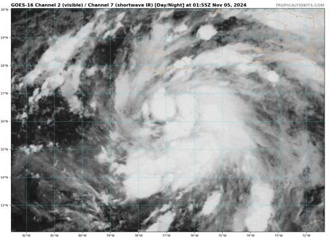
Definitely looking better organized.

0 likes
My posts are my own personal opinion, defer to the National Hurricane Center (NHC) and other NOAA products for decision making during hurricane season.

Re: ATL: RAFAEL - Tropical Storm - Discussion
First recon pass by AF301 found an extrapolated pressure of 995.1 mb with 6 kt winds nearby -> 994/995 mb.
1 likes

Re: ATL: RAFAEL - Tropical Storm - Discussion
Steady pressure, winds on the west side remain very weak. Not a great structure at the moment. It’ll take some time to build up something conducive for RI, so this should mean a MH landfall in Cuba isn’t that likely.
0 likes
Irene '11 Sandy '12 Hermine '16 5/15/2018 Derecho Fay '20 Isaias '20 Elsa '21 Henri '21 Ida '21
I am only a meteorology enthusiast who knows a decent amount about tropical cyclones. Look to the professional mets, the NHC, or your local weather office for the best information.
I am only a meteorology enthusiast who knows a decent amount about tropical cyclones. Look to the professional mets, the NHC, or your local weather office for the best information.
-
wxman57

- Moderator-Pro Met

- Posts: 23171
- Age: 68
- Joined: Sat Jun 21, 2003 8:06 pm
- Location: Houston, TX (southwest)
Re: ATL: RAFAEL - Tropical Storm - Discussion
Ptarmigan wrote:Hurricanes have hit Texas in November.
https://www.weather.gov/media/lch/event ... istory.pdf
Hey, Ptarmigan! Haven't seen you here in a while. Maybe I just missed your posts. I remember Hurricane Jerry striking the Houston area in mid-November of 1989. I was riding a 100 mile bike ride out of Alvin the day before. Terrible headwind the past 30 miles heading east back to Alvin. I came in first on that ride. By mile 98, it was just me and one other guy left. He asked if that was the finish up ahead and I said I wasn't sure. He took off sprinting to get there first, with me on his wheel. I remember the look of defeat on his face as I passed him when he realized there was still one mile to go.
As for Rafael, it is important to note that no model has it at even tropical storm strength when it reaches the coast - either MX/TX or LA/MS. Strong wind shear across the NW Gulf should see to that. It is interesting that the EC and ICON show the west movement, but both dissipate it east of MX/TX early next week. I don't think we'll see a hurricane or even a TS into Texas if it tracks west. My new track has it weakening to a remnant low off the SE LA coast on Sunday morning. Once it moves north of 26N, the shear really hits it hard.
Recon just made its first pass through the center. May be a small area of 35kt wind on the NW side of the center, but pressure is up a bit overnight.
5 likes
-
jlauderdal
- S2K Supporter
- Posts: 7240
- Joined: Wed May 19, 2004 5:46 am
- Location: NE Fort Lauderdale
- Contact:
Re: ATL: RAFAEL - Tropical Storm - Discussion
IR looks decent but the obs tell a different story, nonetheless its Nov 5th and we have a tropical system and possibly more in the near future.
1 likes
Re: ATL: RAFAEL - Tropical Storm - Discussion
54 kt FL winds supports holding the current strength of 50 kt with indeed a pressure around 994 - 995 mb. Improving under the hood and stabilizing, but it's not translating to any real strengthening yet.
0 likes

Re: ATL: RAFAEL - Tropical Storm - Discussion
Recon found it dropped 2mb between passes down to 994 so if that were to continue Havana should be concerned.
0 likes

-
TomballEd
- Category 5
- Posts: 1260
- Age: 62
- Joined: Wed Aug 16, 2023 4:52 pm
- Location: Spring/Klein area, not Tomball
Re: ATL: RAFAEL - Tropical Storm - Discussion
wxman57 wrote:Ptarmigan wrote:Hurricanes have hit Texas in November.
https://www.weather.gov/media/lch/event ... istory.pdf
Hey, Ptarmigan! Haven't seen you here in a while. Maybe I just missed your posts. I remember Hurricane Jerry striking the Houston area in mid-November of 1989. I was riding a 100 mile bike ride out of Alvin the day before. Terrible headwind the past 30 miles heading east back to Alvin. I came in first on that ride. By mile 98, it was just me and one other guy left. He asked if that was the finish up ahead and I said I wasn't sure. He took off sprinting to get there first, with me on his wheel. I remember the look of defeat on his face as I passed him when he realized there was still one mile to go.
As for Rafael, it is important to note that no model has it at even tropical storm strength when it reaches the coast - either MX/TX or LA/MS. Strong wind shear across the NW Gulf should see to that. It is interesting that the EC and ICON show the west movement, but both dissipate it east of MX/TX early next week. I don't think we'll see a hurricane or even a TS into Texas if it tracks west. My new track has it weakening to a remnant low off the SE LA coast on Sunday morning. Once it moves north of 26N, the shear really hits it hard.
Recon just made its first pass through the center. May be a small area of 35kt wind on the NW side of the center, but pressure is up a bit overnight.
Jerry was in October. It was OU weekend. Gardere one the first of 4 straight, the only Texas QB to beat OU 4 times.
0 likes
Who is online
Users browsing this forum: No registered users and 34 guests