

ATL: MILTON - Post-Tropical - Discussion
Moderator: S2k Moderators
Re: ATL: MILTON - Hurricane - Discussion Update= Cat 5 160 mph
10 likes
Igor 2010, Sandy 2012, Fay 2014, Gonzalo 2014, Joaquin 2015, Nicole 2016, Humberto 2019, Imelda 2025
I am only a tropical weather enthusiast. My predictions are not official and may or may not be backed by sound meteorological data. For official information, please refer to the NHC and NWS products.
I am only a tropical weather enthusiast. My predictions are not official and may or may not be backed by sound meteorological data. For official information, please refer to the NHC and NWS products.


Re: ATL: MILTON - Hurricane - Discussion Update= Cat 5 160 mph
storm_in_a_teacup wrote:
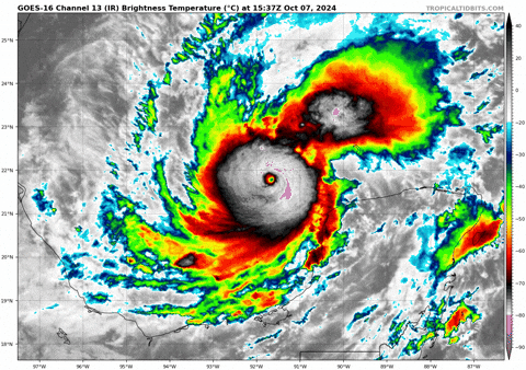
Is that big blow up to the upper right still a part of Milton? Looks so weird
Its part of the feeder band where there is maximum shear.
UL winds moving west to east and LL winds moving east to west.
The LL winds are bringing very high moisture (TPW)
The shear creates uplift.
See these many times with TCs
2 likes

Re: ATL: MILTON - Hurricane - Discussion Update= Cat 5 160 mph
psyclone wrote:What are the chances Milton wrecks itself on the Yucatan?
Seeing as a good chunk of the Yucatan is flat, at most, I could see Milton weakening into a high-end Cat 4 via its current track.
1 likes
-
eastcoastFL

- Category 5

- Posts: 3996
- Age: 44
- Joined: Thu Apr 12, 2007 12:29 pm
- Location: Palm City, FL
Re: ATL: MILTON - Hurricane - Discussion Update= Cat 5 160 mph
psyclone wrote:What are the chances Milton wrecks itself on the Yucatan?
Chances are probably less than 10% since it has zero support. But we can sure hope it does.
2 likes
Personal Forecast Disclaimer:
The posts in this forum are NOT official forecast and should not be used as such. They are just the opinion of the poster and may or may not be backed by sound meteorological data. They are NOT endorsed by any professional institution or storm2k.org. For official information, please refer to the NHC and NWS products.
The posts in this forum are NOT official forecast and should not be used as such. They are just the opinion of the poster and may or may not be backed by sound meteorological data. They are NOT endorsed by any professional institution or storm2k.org. For official information, please refer to the NHC and NWS products.

Re: ATL: MILTON - Hurricane - Discussion Update= Cat 5 160 mph
Recon may come close to measuring the apex of this storm. The improvement in satellite presentation since the last pass is nothing short of astonishing.
4 likes
Very useful information on the Dvorak Technique --
https://severe.worldweather.wmo.int/TCF ... kBeven.pdf
https://severe.worldweather.wmo.int/TCF ... kBeven.pdf
Re: ATL: MILTON - Hurricane - Discussion Update= Cat 5 160 mph
Just about a perfect eye on IR.
He's going below 900mb
He's going below 900mb
11 likes
-
eastcoastFL
- Category 5
- Posts: 3996
- Age: 44
- Joined: Thu Apr 12, 2007 12:29 pm
- Location: Palm City, FL
Re: ATL: MILTON - Hurricane - Discussion Update= Cat 5 160 mph
GCANE wrote:storm_in_a_teacup wrote:
Is that big blow up to the upper right still a part of Milton? Looks so weird
Its part of the feeder band where there is maximum shear.
UL winds moving west to east and LL winds moving east to west.
The LL winds are bringing very high moisture (TPW)
The shear creates uplift.
See these many times with TCs
At some point will it start sucking in some of the moisture from the trough ahead of it?
0 likes
Personal Forecast Disclaimer:
The posts in this forum are NOT official forecast and should not be used as such. They are just the opinion of the poster and may or may not be backed by sound meteorological data. They are NOT endorsed by any professional institution or storm2k.org. For official information, please refer to the NHC and NWS products.
The posts in this forum are NOT official forecast and should not be used as such. They are just the opinion of the poster and may or may not be backed by sound meteorological data. They are NOT endorsed by any professional institution or storm2k.org. For official information, please refer to the NHC and NWS products.
-
storm_in_a_teacup

- Category 1

- Posts: 496
- Age: 33
- Joined: Wed Aug 16, 2017 5:01 pm
- Location: Huntsville, Alabama (originally from Houston)
- Contact:
Re: ATL: MILTON - Hurricane - Discussion Update= Cat 5 160 mph
tolakram wrote:https://i.imgur.com/6N4KWFF.png
So deadly...yet so soft and fluffy looking from afar...
6 likes
I know I can't straddle the atmosphere...just a tiny storm in your teacup, girl.

Re: ATL: MILTON - Hurricane - Discussion Update= Cat 5 160 mph
Airboy wrote:Lot of time left to get bigger in size before land fall.
Which brings a worrisome question regarding the potential greater threat for stronger/higher inland wind speeds. Assuming that an EWRC occurs and max winds within the expanded eyewall are perhaps 140 mph. To what extent would the structural degradation of a larger robust mature hurricane differ, from that of an intense but smaller and more delicate hurricane? Tornados are well known to spin up fast and dissipate just as quickly. It is the nature of their ferocious yet delicate structure. Smaller hurricanes (Milton, Charlie, Andrew, etc) may deepen quite rapidly but small storm fragility commonly results in fairly rapid weakening. I would think that a particularly large hurricane would be apt to degenerate slower in the face of dryer air or increase wind shear. It begs the question to what extent widespread sustained Cat 2 winds could impact inland Florida locations given several combined factors (speed of forward motion included).
3 likes
Andy D
(For official information, please refer to the NHC and NWS products.)
(For official information, please refer to the NHC and NWS products.)
-
eastcoastFL
- Category 5
- Posts: 3996
- Age: 44
- Joined: Thu Apr 12, 2007 12:29 pm
- Location: Palm City, FL
Re: ATL: MILTON - Hurricane - Discussion Update= Cat 5 160 mph
I don't see any signs of a double wind maxima so far. So I don't think an EWRC is in the mix just yet.
3 likes
Personal Forecast Disclaimer:
The posts in this forum are NOT official forecast and should not be used as such. They are just the opinion of the poster and may or may not be backed by sound meteorological data. They are NOT endorsed by any professional institution or storm2k.org. For official information, please refer to the NHC and NWS products.
The posts in this forum are NOT official forecast and should not be used as such. They are just the opinion of the poster and may or may not be backed by sound meteorological data. They are NOT endorsed by any professional institution or storm2k.org. For official information, please refer to the NHC and NWS products.
Re: ATL: MILTON - Hurricane - Discussion Update= Cat 5 160 mph
psyclone wrote:What are the chances Milton wrecks itself on the Yucatan?
Hurricanes have a weird way of avoiding land if they can. Beryl refused to make landfall on Jamaica as it grazed on by, and it did nothing to weaken it. And Jamaica is heavily mountainous, where the Yucatan is flat.
4 likes
Igor 2010, Sandy 2012, Fay 2014, Gonzalo 2014, Joaquin 2015, Nicole 2016, Humberto 2019, Imelda 2025
I am only a tropical weather enthusiast. My predictions are not official and may or may not be backed by sound meteorological data. For official information, please refer to the NHC and NWS products.
I am only a tropical weather enthusiast. My predictions are not official and may or may not be backed by sound meteorological data. For official information, please refer to the NHC and NWS products.
Re: ATL: MILTON - Hurricane - Discussion Update= Cat 5 160 mph
GCANE wrote:Beef Stew wrote:I was wrong earlier when I said it looks like AF is done. They're going in for at least one more pass.
Who said Air Force guys don't pucker.
I hope they're all wearing Depends
3 likes
Andy D
(For official information, please refer to the NHC and NWS products.)
(For official information, please refer to the NHC and NWS products.)
-
Team Getterdun
- Tropical Wave

- Posts: 5
- Joined: Sat Oct 05, 2024 3:04 pm
Re: ATL: MILTON - Hurricane - Discussion Update= Cat 5 160 mph
Steve wrote:Throw that power fist up for GCANE. Unorthodox but ahead of the game as always.
This is something entirely new for me - never heard of this possibly being an influential part of cyclonic activity. I love learning new sh!t

5 likes
-
TomballEd
- Category 5
- Posts: 1246
- Age: 62
- Joined: Wed Aug 16, 2023 4:52 pm
- Location: Spring/Klein area, not Tomball
Re: ATL: MILTON - Hurricane - Discussion Update= Cat 5 160 mph
GCANE wrote:Just about a perfect eye on IR.
He's going below 900mb
Look how warm the eye is! I suspect one can see the ocean surface from space. I was away 90 minutes and wow.
6 likes
Re: ATL: MILTON - Hurricane - Discussion Update= Cat 5 160 mph
eastcoastFL wrote:GCANE wrote:storm_in_a_teacup wrote:
Is that big blow up to the upper right still a part of Milton? Looks so weird
Its part of the feeder band where there is maximum shear.
UL winds moving west to east and LL winds moving east to west.
The LL winds are bringing very high moisture (TPW)
The shear creates uplift.
See these many times with TCs
At some point will it start sucking in some of the moisture from the trough ahead of it?
Trof interaction will be late in the game.
GFS is showing a negative tilt trof just before landfall.
I think this will cause it to rapidly go extratropical over N FL.
It could dump a major portion of its moisture over that area including SE GA / SC.
This could be an epic flood for that area.
1 likes
-
ConvergenceZone
.gif)
- Category 5
- Posts: 5241
- Joined: Fri Jul 29, 2005 1:40 am
- Location: Northern California
Re: ATL: MILTON - Hurricane - Discussion Update= Cat 5 160 mph
Thank God this is a small hurricane, but didn't I read somewhere that it's possible that it might increase a little bit before landfall?
0 likes
Re: ATL: MILTON - Hurricane - Discussion Update= Cat 5 160 mph
Pasmorade wrote:psyclone wrote:What are the chances Milton wrecks itself on the Yucatan?
Seeing as a good chunk of the Yucatan is flat, at most, I could see Milton weakening into a high-end Cat 4 via its current track.
Nah it would destroy the pressure gradient and wreck it.. see Isidore 2002 or just any other tightly knotted vortex that interacts with a landmass. It doesn't end well for the storm. This possibility deserves more discussion
0 likes

Re: ATL: MILTON - Hurricane - Discussion Update= Cat 5 160 mph
The blob in the NE looks like a separate competing system. LOL. Any ideas on this?
0 likes
Re: ATL: MILTON - Hurricane - Discussion Update= Cat 5 160 mph
Recon just made a turn, going to the eye now
1 likes
Very useful information on the Dvorak Technique --
https://severe.worldweather.wmo.int/TCF ... kBeven.pdf
https://severe.worldweather.wmo.int/TCF ... kBeven.pdf
Re: ATL: MILTON - Hurricane - Discussion Update= Cat 5 160 mph
psyclone wrote:Pasmorade wrote:psyclone wrote:What are the chances Milton wrecks itself on the Yucatan?
Seeing as a good chunk of the Yucatan is flat, at most, I could see Milton weakening into a high-end Cat 4 via its current track.
Nah it would destroy the pressure gradient and wreck it.. see Isidore 2002 or just any other tightly knotted vortex that interacts with a landmass. It doesn't end well for the storm. This possibility deserves more discussion
Good point. However, Isidore was shot into the Yucatan due to a high and stalled over the area for over a day. Although I think that Milton has a chance of crossing into the Yucatan, I don't think it'll be inland enough to weak it significantly.
Last edited by Pasmorade on Mon Oct 07, 2024 11:51 am, edited 1 time in total.
1 likes
Who is online
Users browsing this forum: No registered users and 8 guests