ATL: INVEST 92L - Discussion
Moderator: S2k Moderators


Re: ATL: INVEST 92L - Discussion
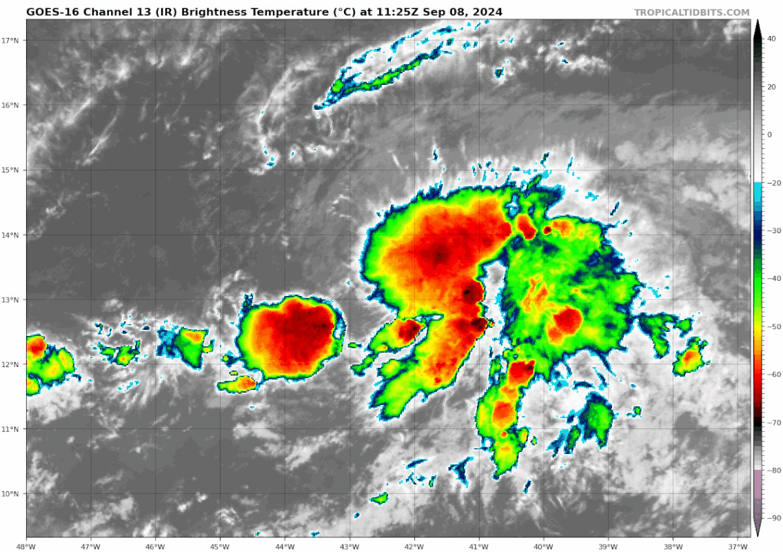
Best looking wave in the MDR since quite a while. Even for Debby and Ernesto their waves were in rough shape. Lots of convection, could be a big ACE generator
2 likes

Re: ATL: INVEST 92L - Discussion
This does look like something trying to become a TC, regardless of what models are showing.

Last edited by Teban54 on Sun Sep 08, 2024 11:29 am, edited 1 time in total.
7 likes
TC naming lists: retirements and intensity
Most aggressive Advisory #1's in North Atlantic (cr. kevin for starting the list)
Most aggressive Advisory #1's in North Atlantic (cr. kevin for starting the list)
-
wzrgirl1

- S2K Supporter

- Posts: 1360
- Joined: Sat Sep 04, 2004 6:44 am
- Location: Pembroke Pines, Florida
Re: ATL: INVEST 92L - Discussion
Well it's at 60% in the long term so I guess the NHC sees something.
0 likes
-
PDKlikatino
- Tropical Low

- Posts: 20
- Age: 19
- Joined: Tue Aug 13, 2024 5:16 pm
- Location: Tampa, FL
Re: ATL: INVEST 92L - Discussion
Yikes, this little guy popped up out of nowhere! NHC has it at 60% in the short term and 70% in the next five days now. I wonder what changed from being a low chance just a couple days ago?
4 likes
My posts are not official forecasts, just guesses. For accurate information, visit the NHC or NWS websites instead.
-
Sciencerocks
- Category 5

- Posts: 10181
- Age: 40
- Joined: Thu Jul 06, 2017 1:51 am
Re: ATL: INVEST 92L - Discussion

Looks like a depression if not a storm! Almost better then 91L but I'd say both are currently deserving.
3 likes
Re: ATL: INVEST 92L - Discussion
I wasn't expecting a cherry update honestly. NHC is clearly going with real-time trends rather than model hugging; big props if this does end up verifying.
Convection has waned a bit in recent frames, but it's Dmin.
Convection has waned a bit in recent frames, but it's Dmin.
3 likes
TC naming lists: retirements and intensity
Most aggressive Advisory #1's in North Atlantic (cr. kevin for starting the list)
Most aggressive Advisory #1's in North Atlantic (cr. kevin for starting the list)
-
Cachondo23
- Tropical Storm

- Posts: 131
- Joined: Wed May 25, 2022 5:56 am
Re: ATL: INVEST 92L - Discussion
cycloneye wrote:AL, 92, 2024090812, , BEST, 0, 132N, 424W, 25, 1010, LO
https://i.imgur.com/3CFcDSD.png
Very weird track
0 likes
-
Blown Away

- S2K Supporter
- Posts: 10253
- Joined: Wed May 26, 2004 6:17 am
Re: ATL: INVEST 92L - Discussion
Are the days a W moving TW and/or Hurricane making it past 70W over???
1 likes
Hurricane Eye Experience: David 79, Irene 99, Frances 04, Jeanne 04, Wilma 05… Hurricane Brush Experience: Andrew 92, Erin 95, Floyd 99, Matthew 16, Irma 17, Ian 22, Nicole 22…

Re: ATL: INVEST 92L - Discussion
Blown Away wrote:Are the days a W moving TW and/or Hurricane making it past 70W over???
That’s because the Bermuda high has been nonexistent this season past Beryl
0 likes

Re: ATL: INVEST 92L - Discussion
boca wrote:Blown Away wrote:Are the days a W moving TW and/or Hurricane making it past 70W over???
That’s because the Bermuda high has been nonexistent this season past Beryl
That’s not entirely true as pre-91L had a very anomalously strong Bermuda high overhead as it was crossing the Caribbean. Unlikely to hold for this system, but that’s climatology as fewer than 10% of CV systems successfully make the trek and that rate is even lower this time of year.
1 likes
Kendall -> SLO -> PBC
Memorable Storms: Katrina (for its Florida landfall...) Wilma Matthew Irma
Memorable Storms: Katrina (for its Florida landfall...) Wilma Matthew Irma

Re: ATL: INVEST 92L - Discussion
8 PM:
Central Tropical Atlantic (AL92):
Showers and thunderstorms associated with an area of low pressure
over the central tropical Atlantic have changed little in
organization since earlier today. Environmental conditions appear
conducive for additional development during the next couple of days,
and a tropical depression is likely to form during that time while
the system meanders over the central tropical Atlantic. By the
middle of the week, the system should begin moving more westward at
around 10 mph.
* Formation chance through 48 hours...medium...60 percent.
* Formation chance through 7 days...high...70 percent.
1 likes
Re: ATL: INVEST 92L - Discussion
Remains at 60/70, even though the vigorous convection earlier has waned and been replaced by two towers (albeit a pretty big one)
1. Central Tropical Atlantic (AL92):
An area of low pressure is producing disorganized showers and
thunderstorms over the central tropical Atlantic. Environmental
conditions appear generally conducive for development during the
next few days, and a tropical depression is expected to form while
the system meanders over the central tropical Atlantic. By the
middle of the week, the system should begin move
westward-northwestward at around 10 mph.
* Formation chance through 48 hours...medium...60 percent.
* Formation chance through 7 days...high...70 percent.
0 likes
TC naming lists: retirements and intensity
Most aggressive Advisory #1's in North Atlantic (cr. kevin for starting the list)
Most aggressive Advisory #1's in North Atlantic (cr. kevin for starting the list)
-
WeatherBoy2000
- Category 1

- Posts: 460
- Joined: Mon Apr 10, 2023 9:29 am
Re: ATL: INVEST 92L - Discussion
It's now back down to an orange, not looking so healthy today.
0 likes
-
Category5Kaiju

- Category 5
- Posts: 4330
- Joined: Thu Dec 24, 2020 12:45 pm
- Location: Seattle and Phoenix
Re: ATL: INVEST 92L - Discussion
WeatherBoy2000 wrote:It's now back down to an orange, not looking so healthy today.
Looks like the area behind it will be the victor after all. Gotta give credit to the models (like the Euro) that weren't very optimistic about this particular disturbance.
1 likes
Unless explicitly stated, all info in my posts is based on my own opinions and observations. Tropical storms and hurricanes can be extremely dangerous. Refer to an accredited weather research agency or meteorologist if you need to make serious decisions regarding an approaching storm.

Re: ATL: INVEST 92L - Discussion
The problem is with 92L is that it is a 3 or even 4 bodied problem. The models have it emerging for these waves and another wave coming off the coast of Africa it's this that is causing a problem with the models and the on off nature of them, there figuring out which one has the dominance to form in to a storm or two.

1 likes
Re: ATL: INVEST 92L - Discussion
NHC is saying maybe a depression or weak storm in the short term, which there is still model support for.
0 likes
Kendall -> SLO -> PBC
Memorable Storms: Katrina (for its Florida landfall...) Wilma Matthew Irma
Memorable Storms: Katrina (for its Florida landfall...) Wilma Matthew Irma

Re: ATL: INVEST 92L - Discussion
ChrisH-UK wrote:The problem is with 92L is that it is a 3 or even 4 bodied problem. The models have it emerging for these waves and another wave coming off the coast of Africa it's this that is causing a problem with the models and the on off nature of them, there figuring out which one has the dominance to form in to a storm or two.
[url]https://imagizer.imageshack.com/img924/1919/TYwQDa.gif [/url]
I could see 2 or 3 different systems to come out of this mess.
0 likes
Personal Forecast Disclaimer:
The posts in this forum are NOT official forecast and should not be used as such. They are just the opinion of the poster and may or may not be backed by sound meteorological data. They are NOT endorsed by any professional institution or storm2k.org. For official information, please refer to the NHC and NWS products.
The posts in this forum are NOT official forecast and should not be used as such. They are just the opinion of the poster and may or may not be backed by sound meteorological data. They are NOT endorsed by any professional institution or storm2k.org. For official information, please refer to the NHC and NWS products.

Re: ATL: INVEST 92L - Discussion
Blinhart wrote:ChrisH-UK wrote:The problem is with 92L is that it is a 3 or even 4 bodied problem. The models have it emerging for these waves and another wave coming off the coast of Africa it's this that is causing a problem with the models and the on off nature of them, there figuring out which one has the dominance to form in to a storm or two.
[url]https://imagizer.imageshack.com/img924/1919/TYwQDa.gif [/url]
I could see 2 or 3 different systems to come out of this mess.
Perhaps. In any other year I'd say probable. In fact, while all the chatter is over 92L and the wave further east.... I'm more focused on the ITCZ disturbance at 12N and 52W! I see some level of rotation to it right now.
1 likes
Andy D
(For official information, please refer to the NHC and NWS products.)
(For official information, please refer to the NHC and NWS products.)
Re: ATL: INVEST 92L - Discussion
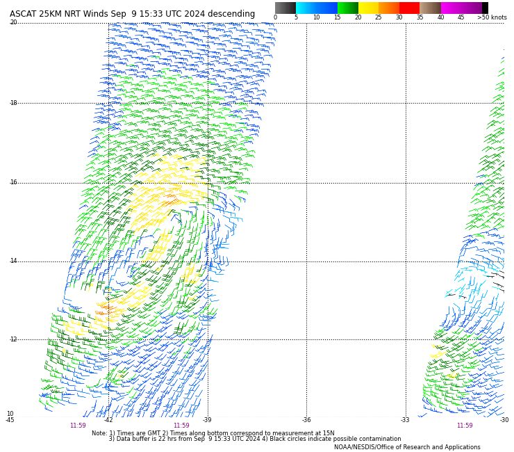
ASCAT pass in the morning shows an elongated circulation (which may have been there earlier, I didn't check), and that contributed to 92L looking decent on visible satellite. However, the main problem right now is that 92L has failed to sustain convection. Perhaps because too many competing vorts are around?

1 likes
TC naming lists: retirements and intensity
Most aggressive Advisory #1's in North Atlantic (cr. kevin for starting the list)
Most aggressive Advisory #1's in North Atlantic (cr. kevin for starting the list)
Who is online
Users browsing this forum: No registered users and 35 guests