ATL: BERYL - Post-Tropical - Discussion
Moderator: S2k Moderators


Re: ATL: BERYL - Hurricane - Discussion
Just waking up and the structure is looking way better than I thought it was going to this morning. Looked like it was going to be a total mess this morning as woke up and now the structure of the core looks more impressive.
4 likes
Not a professional meteorologist. Please refer to NHC forecasts for official information/advice relating to tropical systems.
-
ScottNAtlanta

- Category 5

- Posts: 2535
- Joined: Sat May 25, 2013 3:11 pm
- Location: Atlanta, GA
Re: ATL: BERYL - Hurricane - Discussion
Beryl keeps on keepin' on

4 likes
The posts in this forum are NOT official forecast and should not be used as such. They are just the opinion of the poster and may or may not be backed by sound meteorological data. They are NOT endorsed by any professional institution or storm2k.org. For official information, please refer to the NHC and NWS products.

Re: ATL: BERYL - Hurricane - Discussion
Barely a major with rising pressures based on the two center passes. Maybe only 95 kt/968 mbar.
0 likes
Irene '11 Sandy '12 Hermine '16 5/15/2018 Derecho Fay '20 Isaias '20 Elsa '21 Henri '21 Ida '21
I am only a meteorology enthusiast who knows a decent amount about tropical cyclones. Look to the professional mets, the NHC, or your local weather office for the best information.
I am only a meteorology enthusiast who knows a decent amount about tropical cyclones. Look to the professional mets, the NHC, or your local weather office for the best information.

Re: ATL: BERYL - Hurricane - Discussion
VDM
11:40Z
Max Surface Wind: 97knts
970mb
18.71N 81.46W
20nm circular eye, open s to SE
11:40Z
Max Surface Wind: 97knts
970mb
18.71N 81.46W
20nm circular eye, open s to SE
0 likes
-
otowntiger
- Category 5
- Posts: 1932
- Joined: Tue Aug 31, 2004 7:06 pm
Re: ATL: BERYL - Hurricane - Discussion
very true. Any short term movement observed via satellite or radar doesn’t tell the whole story. The NHC has way more tools and methods for determining track and have it pretty much nailed at this point in the three day period at least, especially the next 24 hours.jlauderdal wrote:kevin wrote:Beryl does seem to have a more pronounced NW movement the last few hours. It's difficult to see exactly since it isn't always easy to see where the center is exactly at the moment. But it looks like it gained about 0.4 deg latitude during its last 1 deg of longitude. Extrapolating that would put it almost out of the cone at the Yucatan landfall, almost missing Yucatan altogether. But I wouldn't make any conclusions right now, let's see what the trend is over the rest of the day.
Be very careful XTRAPing anything, these systems wobble. The NHC has enough recon out there to know where the ridge is and how strong it is, is the track going to move North, maybe, but not enough to satisfy some people. NHC is too good on track inside of 5 days for any major changes, 75 miles on either side of the tx/mx border is a good bet. Cheap Tecate in Matamoros, park your car, walk across the bridge, walk back. Cheers from SOFLA where we are getting crushed with heat advisories. FLORIDIANS-the ridge isn't going to be this strong forever.
A RECORD HIGH MINIMUM TEMPERATURE OF 83 DEGREES WAS OBSERVED AT FORT
LAUDERDALE YESTERDAY. THIS BREAKS THE OLD RECORD OF 82 DEGREES SET
IN 2022.
1 likes
-
otowntiger
- Category 5
- Posts: 1932
- Joined: Tue Aug 31, 2004 7:06 pm
Re: ATL: BERYL - Hurricane - Discussion
very true. Any short term movement observed via satellite or radar doesn’t tell the whole story. The NHC has way more tools and methods for determining track and have it pretty much nailed at this point in the three day period at least, especially the next 24 hours.jlauderdal wrote:kevin wrote:Beryl does seem to have a more pronounced NW movement the last few hours. It's difficult to see exactly since it isn't always easy to see where the center is exactly at the moment. But it looks like it gained about 0.4 deg latitude during its last 1 deg of longitude. Extrapolating that would put it almost out of the cone at the Yucatan landfall, almost missing Yucatan altogether. But I wouldn't make any conclusions right now, let's see what the trend is over the rest of the day.
Be very careful XTRAPing anything, these systems wobble. The NHC has enough recon out there to know where the ridge is and how strong it is, is the track going to move North, maybe, but not enough to satisfy some people. NHC is too good on track inside of 5 days for any major changes, 75 miles on either side of the tx/mx border is a good bet. Cheap Tecate in Matamoros, park your car, walk across the bridge, walk back. Cheers from SOFLA where we are getting crushed with heat advisories. FLORIDIANS-the ridge isn't going to be this strong forever.
A RECORD HIGH MINIMUM TEMPERATURE OF 83 DEGREES WAS OBSERVED AT FORT
LAUDERDALE YESTERDAY. THIS BREAKS THE OLD RECORD OF 82 DEGREES SET
IN 2022.
0 likes

Re: ATL: BERYL - Hurricane - Discussion
Teban54 wrote:https://i.postimg.cc/TP86MwmP/Beryl-4-Jul24-Cayman.gif
Looks like it took a jog north after it got away from Jamaica and looks to be intensifying, JM2C.
0 likes
Re: ATL: BERYL - Hurricane - Discussion
GCANE wrote:VDM
11:40Z
Max Surface Wind: 97knts
970mb
18.71N 81.46W
20nm circular eye, open s to SE
Eyedrop has 82% RH at 850mb
.
No wobble, definitely north of forecast track (should be 18.45N at 81.5W)
About 20nm north.
0 likes
Re: ATL: BERYL - Hurricane - Discussion
That ULL in the GoM is definitely doing its job pulling Beryl north
1 likes
Re: ATL: BERYL - Hurricane - Discussion
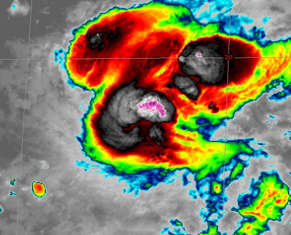
Hot Towers a poppin and a Feeder Band may be kicking in.
Over the max OHC water in the Atlantic
Over the max OHC water in the Atlantic
2 likes
-
tropicwatch

- Category 5
- Posts: 3427
- Age: 62
- Joined: Sat Jun 02, 2007 10:01 am
- Location: The Villages, Florida
- Contact:
Re: ATL: BERYL - Hurricane - Discussion
07042024 6:55am Central Time
Last edited by tropicwatch on Thu Jul 04, 2024 7:03 am, edited 1 time in total.
3 likes
Tropicwatch
Agnes 72', Eloise 75, Elena 85', Kate 85', Charley 86', Florence 88', Beryl 94', Dean 95', Erin 95', Opal 95', Earl 98', Georges 98', Ivan 2004', Arlene 2005', Dennis 2005', Ida 2009' Debby 2012' Irma 2017' Michael 2018'
Agnes 72', Eloise 75, Elena 85', Kate 85', Charley 86', Florence 88', Beryl 94', Dean 95', Erin 95', Opal 95', Earl 98', Georges 98', Ivan 2004', Arlene 2005', Dennis 2005', Ida 2009' Debby 2012' Irma 2017' Michael 2018'
Re: ATL: BERYL - Hurricane - Discussion
That rapidly developing convection on the NW side will plow through any shear like a hot knife
0 likes
Re: ATL: BERYL - Hurricane - Discussion
Mr Shear is takin a lickin while Beryl keeps on a tickin
2 likes
Re: ATL: BERYL - Hurricane - Discussion
The Fujiwhara rotational axis of the GoM ULL and Beryl is right in the middle of the Yucatan Channel
0 likes

Re: ATL: BERYL - Hurricane - Discussion
The first two NOAA passes measured a peak 107 kt FL winds and 101 kt SFMR, blending to a 100 kt intensity. Looks like NHC went with 105 kt for now, probably accounting for undersampling and to just wait and see whether upcoming passes show continued weakening or perhaps find some higher winds.
0 likes
-
wxman57

- Moderator-Pro Met

- Posts: 23175
- Age: 68
- Joined: Sat Jun 21, 2003 8:06 pm
- Location: Houston, TX (southwest)
Re: ATL: BERYL - Hurricane - Discussion
Beryl looks on-track to make landfall about 70 miles south of Brownsville late Sunday evening, probably as a Cat 1. Hurricane models have been in very good agreement on landfall between Tampico and Brownsville. A landfall south of Brownsville would produce tropical storm force wind into Brownsville, but Corpus Christi would experience 25-35 mph wind. Of course, much will depend on how much it weakens after crossing the Yucatan. It's a relatively small hurricane. Small hurricanes are much more fragile than large ones.
5 likes
-
jlauderdal
- S2K Supporter

- Posts: 7240
- Joined: Wed May 19, 2004 5:46 am
- Location: NE Fort Lauderdale
- Contact:
Re: ATL: BERYL - Hurricane - Discussion
otowntiger wrote:very true. Any short term movement observed via satellite or radar doesn’t tell the whole story. The NHC has way more tools and methods for determining track and have it pretty much nailed at this point in the three day period at least, especially the next 24 hours.jlauderdal wrote:kevin wrote:Beryl does seem to have a more pronounced NW movement the last few hours. It's difficult to see exactly since it isn't always easy to see where the center is exactly at the moment. But it looks like it gained about 0.4 deg latitude during its last 1 deg of longitude. Extrapolating that would put it almost out of the cone at the Yucatan landfall, almost missing Yucatan altogether. But I wouldn't make any conclusions right now, let's see what the trend is over the rest of the day.
Be very careful XTRAPing anything, these systems wobble. The NHC has enough recon out there to know where the ridge is and how strong it is, is the track going to move North, maybe, but not enough to satisfy some people. NHC is too good on track inside of 5 days for any major changes, 75 miles on either side of the tx/mx border is a good bet. Cheap Tecate in Matamoros, park your car, walk across the bridge, walk back. Cheers from SOFLA where we are getting crushed with heat advisories. FLORIDIANS-the ridge isn't going to be this strong forever.
A RECORD HIGH MINIMUM TEMPERATURE OF 83 DEGREES WAS OBSERVED AT FORT
LAUDERDALE YESTERDAY. THIS BREAKS THE OLD RECORD OF 82 DEGREES SET
IN 2022.
Wobble watching is part of the deal and every wobble matters, in this case a few wobbles north isnt sending it to houston or LA. Wobbles are a big deal when nearing landfall, it can be the difference between having your roof blown off or just limbs down. Also, angle of approach, consider IAN and the angle it came in, minor changes had big implications downstream due to the angle. Looks quiet after Beryl but it looked quiet before Beryl. Good time to stock up on 12/3 extension cords for use inside your house.
0 likes
-
jlauderdal
- S2K Supporter
- Posts: 7240
- Joined: Wed May 19, 2004 5:46 am
- Location: NE Fort Lauderdale
- Contact:
Re: ATL: BERYL - Hurricane - Discussion
wxman57 wrote:Beryl looks on-track to make landfall about 70 miles south of Brownsville late Sunday evening, probably as a Cat 1. Hurricane models have been in very good agreement on landfall between Tampico and Brownsville. A landfall south of Brownsville would produce tropical storm force wind into Brownsville, but Corpus Christi would experience 25-35 mph wind. Of course, much will depend on how much it weakens after crossing the Yucatan. It's a relatively small hurricane. Small hurricanes are much more fragile than large ones.
Good job on your track in spite of mixed signals from the models and initialization issues for several days now. Human intervention with experience looking at tropical systems is required to come up with a good track, I see ICON hugging on the twitter, it really needs to stop. WXMAN57 put out a track that was a little too far south but well within the "error" rate, considering how far out in time he put his track out for public consumption. I see 96L is following similar track even south, the ridge is strong and beryl isnt busting through it heading to the TX/LA border. Houston peeps, you want to know what is happening, follow Matt Lanza and Jeff Lindner for all things Houston, they know the enviornment and Lindner knows every square inch of topography and how it floods. They are also fantastic on communication!
2 likes
-
jlauderdal
- S2K Supporter
- Posts: 7240
- Joined: Wed May 19, 2004 5:46 am
- Location: NE Fort Lauderdale
- Contact:
Re: ATL: BERYL - Hurricane - Discussion
GCANE wrote:Wow, 65mm/hr rain rate. Another cylinder firing up
Is Beryl a 6-cylinder or still an 8-cylinder?
Dont be fooled by pics coming out of Kingston or Montego Bay, Southwest Jamaica into the Blue Mountains took a beating, was listening to Nationwide last night and this morning, wind was a huge issue with roofs-not just tin roofs either.
3 likes
Who is online
Users browsing this forum: No registered users and 48 guests