ATL: HELENE - Post-Tropical - Discussion
Moderator: S2k Moderators

Re: ATL: HELENE - Hurricane - Discussion
I do see NE motion, or am i just seeing things now? I know it's supposed to be doing this, but..
0 likes

Re: ATL: HELENE - Hurricane - Discussion
xironman wrote:GCANE wrote:Kohlecane wrote:Yeah I'm here near Beaufort that's my concern
Stay safe my friend
TOR risk
https://i.imgur.com/9SlSZsn.png

10% usually indicates a tornado outbreak
0 likes
-
HurricaneBelle

- S2K Supporter

- Posts: 1209
- Joined: Sun Aug 27, 2006 6:12 pm
- Location: Clearwater, FL
Re: ATL: HELENE - Hurricane - Discussion
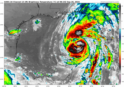
Just woke up and first thing I did was grab the phone off the nightstand to check out RadarScope and saw this. For a minute I thought that echo to my west in the Gulf was the hurricane and was thinking "how did it get to my latitude so fast?" It really looks like an eye.

2 likes
-
eastcoastFL

- Category 5

- Posts: 3996
- Age: 44
- Joined: Thu Apr 12, 2007 12:29 pm
- Location: Palm City, FL
Re: ATL: HELENE - Hurricane - Discussion

1 likes
Personal Forecast Disclaimer:
The posts in this forum are NOT official forecast and should not be used as such. They are just the opinion of the poster and may or may not be backed by sound meteorological data. They are NOT endorsed by any professional institution or storm2k.org. For official information, please refer to the NHC and NWS products.
The posts in this forum are NOT official forecast and should not be used as such. They are just the opinion of the poster and may or may not be backed by sound meteorological data. They are NOT endorsed by any professional institution or storm2k.org. For official information, please refer to the NHC and NWS products.
Re: ATL: HELENE - Hurricane - Discussion
Can't keep that eye closed, I wonder if those racing mesos are disrupting it.
F. Eye Character: Open in the west
G. Eye Shape & Diameter: Circular with a diameter of 32 nautical miles (37 statute miles)
G. Eye Shape & Diameter: Circular with a diameter of 32 nautical miles (37 statute miles)
0 likes
-
Hypercane_Kyle

- Category 5
- Posts: 3465
- Joined: Sat Mar 07, 2015 7:58 pm
- Location: Cape Canaveral, FL
Re: ATL: HELENE - Hurricane - Discussion
Based on recon data, I'd go with 100 mph at 8am.
Tough to get large storms to explosively RI, so I'm not surprised that we're still looking at a Cat 1 this AM. Reminds me a lot of Ike ~ Cat 2 with catastrophic storm surge. 105-110 knots at landfall seems reasonable though.
Tough to get large storms to explosively RI, so I'm not surprised that we're still looking at a Cat 1 this AM. Reminds me a lot of Ike ~ Cat 2 with catastrophic storm surge. 105-110 knots at landfall seems reasonable though.
Last edited by Hypercane_Kyle on Thu Sep 26, 2024 6:28 am, edited 1 time in total.
0 likes
My posts are my own personal opinion, defer to the National Hurricane Center (NHC) and other NOAA products for decision making during hurricane season.
-
eastcoastFL
- Category 5
- Posts: 3996
- Age: 44
- Joined: Thu Apr 12, 2007 12:29 pm
- Location: Palm City, FL
Re: ATL: HELENE - Hurricane - Discussion
LandoWill wrote:I do see NE motion, or am i just seeing things now? I know it's supposed to be doing this, but..
It’s moving NE.
0 likes
Personal Forecast Disclaimer:
The posts in this forum are NOT official forecast and should not be used as such. They are just the opinion of the poster and may or may not be backed by sound meteorological data. They are NOT endorsed by any professional institution or storm2k.org. For official information, please refer to the NHC and NWS products.
The posts in this forum are NOT official forecast and should not be used as such. They are just the opinion of the poster and may or may not be backed by sound meteorological data. They are NOT endorsed by any professional institution or storm2k.org. For official information, please refer to the NHC and NWS products.

-
ScottNAtlanta

- Category 5
- Posts: 2535
- Joined: Sat May 25, 2013 3:11 pm
- Location: Atlanta, GA
Re: ATL: HELENE - Hurricane - Discussion
xironman wrote:Can't keep that eye closed, I wonder if those racing mesos are disrupting it.F. Eye Character: Open in the west
G. Eye Shape & Diameter: Circular with a diameter of 32 nautical miles (37 statute miles)
From what I'm reading, it's the same thing as last night...concentric eyewalls. The main one is too small and there is a secondary
0 likes
The posts in this forum are NOT official forecast and should not be used as such. They are just the opinion of the poster and may or may not be backed by sound meteorological data. They are NOT endorsed by any professional institution or storm2k.org. For official information, please refer to the NHC and NWS products.
Re: ATL: HELENE - Hurricane - Discussion
eastcoastFL wrote:LandoWill wrote:I do see NE motion, or am i just seeing things now? I know it's supposed to be doing this, but..
It’s moving NE.
I guess the key is at about 2pm it's supposed to go more northward, if it doesn't, then more rain on the west coast
0 likes
Re: ATL: HELENE - Hurricane - Discussion
TomballEd wrote:ColdMiser123 wrote:104 kt flight level wind in the east eyewall - supports 94 kt at the surface. More sharp pressure falls as well. Strong case this is now a Category 2.
HDOB with 0 wind supports 963.8 mb. Looking at satellite, I think this gets closer to Tampa than people think. Landfall will be further N, but with a large wind field, I have concerns affects in Tampa may be more significant than people think.
https://i.giphy.com/media/v1.Y2lkPTc5MGI3NjExb2g5Ym82eGI1MnE2Y2U4amMyeHZsMGJtZnMxd2hpczQ4dTJjMjVraCZlcD12MV9pbnRlcm5hbF9naWZfYnlfaWQmY3Q9Zw/MOi7kYmlTpVxvOSUo8/giphy.gif
Im in Manatee County 30 miles south of Tampa and judging by the wind gusts we are getting already I'm a bit concerned
2 likes

Re: ATL: HELENE - Hurricane - Discussion
GCANE wrote:Based on Miss Piggy's latest pass, Helene looks to be just a few miles east of forecast track.
I haven't learned how to "Add" an appropriate overlay in google earth yet but I painted some red lines to make a stupid cone.

2 likes
-
southmdwatcher
- Tropical Low

- Posts: 25
- Joined: Thu Aug 14, 2008 5:35 am
Re: ATL: HELENE - Hurricane - Discussion
I thought the 500mb upper low was supposed to cut off over Arkansas or Oklahoma. It is currently hanging out over western Kentucky and Tennessee. Wouldn't that force the track of Helene not just 30 to 50 miles east, but much more?
3 likes

Re: ATL: HELENE - Hurricane - Discussion
southmdwatcher wrote:I thought the 500mb upper low was supposed to cut off over Arkansas or Oklahoma. It is currently hanging out over western Kentucky and Tennessee. Wouldn't that force the track of Helene not just 30 to 50 miles east, but much more?
I've asked similar questions, but no responses. I think people are hyper focused on landfall.
Last edited by SoupBone on Thu Sep 26, 2024 6:38 am, edited 1 time in total.
3 likes
Personal Forecast Disclaimer:
The posts in this forum are NOT official forecast and should not be used as such. They are just the opinion of the poster and may or may not be backed by sound meteorological data. They are NOT endorsed by any professional institution or storm2k.org. For official information, please refer to the NHC and NWS products.
The posts in this forum are NOT official forecast and should not be used as such. They are just the opinion of the poster and may or may not be backed by sound meteorological data. They are NOT endorsed by any professional institution or storm2k.org. For official information, please refer to the NHC and NWS products.
-
HurricaneAndre2008

- Category 1

- Posts: 356
- Age: 28
- Joined: Wed Jul 31, 2019 9:51 pm
- Contact:
Re: ATL: HELENE - Hurricane - Discussion
F. CLOSED
G. C36
G. C36
4 likes
Cindy(2005), Katrina(2005), Rita(2005), Erin(2007), Isaac(2012)
-
MetsIslesNoles

- S2K Supporter
- Posts: 64
- Joined: Thu Jul 07, 2005 10:42 pm
- Location: Tallahassee, FL
Re: ATL: HELENE - Hurricane - Discussion
Question for anyone that can direct me. I’m looking at the hourly wind speed forecast for Tallahassee at the NWS and it’s saying the peak gusts are 60 mph tonight? Am I looking at a wrong view?
0 likes
Re: ATL: HELENE - Hurricane - Discussion
VDM just came in from Miss Piggy.
The outer eyewall took over and is closed.
Doubt we will see another EWRC.
Cat 4 at landfall is probable.
F. Eye Character: Closed
G. Eye Shape & Diameter: Circular with a diameter of 36 nautical miles (41 statute miles)
The outer eyewall took over and is closed.
Doubt we will see another EWRC.
Cat 4 at landfall is probable.
F. Eye Character: Closed
G. Eye Shape & Diameter: Circular with a diameter of 36 nautical miles (41 statute miles)
5 likes
-
HurricaneAndre2008
- Category 1
- Posts: 356
- Age: 28
- Joined: Wed Jul 31, 2019 9:51 pm
- Contact:
Re: ATL: HELENE - Hurricane - Discussion
677
WTNT34 KNHC 261139
TCPAT4
BULLETIN
Hurricane Helene Intermediate Advisory Number 12A
NWS National Hurricane Center Miami FL AL092024
700 AM CDT Thu Sep 26 2024
...HELENE BECOMES A CATEGORY 2 HURRICANE WITH SIGNIFICANT
ADDITIONAL STRENGTHENING EXPECTED BEFORE LANDFALL IN FLORIDA...
...PREPARATIONS TO PROTECT LIFE AND PROPERTY SHOULD BE RUSHED TO
COMPLETION...
SUMMARY OF 700 AM CDT...1200 UTC...INFORMATION
----------------------------------------------
LOCATION...24.5N 85.9W
ABOUT 320 MI...515 KM SW OF TAMPA FLORIDA
ABOUT 365 MI...585 KM S OF APALACHICOLA FLORIDA
MAXIMUM SUSTAINED WINDS...100 MPH...155 KM/H
PRESENT MOVEMENT...NNE OR 15 DEGREES AT 12 MPH...19 KM/H
MINIMUM CENTRAL PRESSURE...960 MB...28.35 INCHES
3 likes
Cindy(2005), Katrina(2005), Rita(2005), Erin(2007), Isaac(2012)

Re: ATL: HELENE - Hurricane - Discussion
GCANE wrote:VDM just came in from Miss Piggy.
The outer eyewall took over and is closed.
Doubt we will see another EWRC.
Cat 4 at landfall is probable.
F. Eye Character: Closed
G. Eye Shape & Diameter: Circular with a diameter of 36 nautical miles (41 statute miles)
MPERC 09z also only had a 3% chance of ERC onset so combined with the recon data I think it's unlikely we'll see another EWRC before landfall.
2 likes
-
InfernoFlameCat

- Category 5
- Posts: 2127
- Age: 22
- Joined: Mon Dec 14, 2020 10:52 am
- Location: Buford, GA
Re: ATL: HELENE - Hurricane - Discussion
GCANE wrote:VDM just came in from Miss Piggy.
The outer eyewall took over and is closed.
Doubt we will see another EWRC.
Cat 4 at landfall is probable.
F. Eye Character: Closed
G. Eye Shape & Diameter: Circular with a diameter of 36 nautical miles (41 statute miles)
Oh man. It's off to the races with what, 16 hours till landfall? We should see the whole storm blow up with convection soon.
1 likes
I am by no means a professional. DO NOT look at my forecasts for official information or make decisions based on what I post.
Goal: to become a registered expert over tropical and subtropical cyclones.
Goal: to become a registered expert over tropical and subtropical cyclones.
Who is online
Users browsing this forum: Google Adsense [Bot] and 25 guests