12:30pm Video on Helene
https://www.youtube.com/watch?v=CQY6JmfLGVU
ATL: HELENE - Post-Tropical - Discussion
Moderator: S2k Moderators
-
Hurricane Mike
- Category 2

- Posts: 675
- Joined: Tue Apr 10, 2018 7:44 am
Re: ATL: HELENE - Hurricane - Discussion
tolakram wrote:NDG wrote:From my good friend Pro Met T Scott:Your boys are TOO FAR WEST with their landfall, Deni.
T. Scott believes this will PASS EAST of Apalachee Bay; NOT WEST.
2 Vort. Lobes circulating the base of the upper low/trough 1st heads SE from coastal MS/AL at 7 AM this morning. This should result in the first turn N-NE. 2nd vort. lobe comes this afternoon, emanating EASTward from Western AL/Cstl AL/SE LA bootip. diving Eastward.
The natural gravitation towards STEEP DEEPENING and strengthening will also tend to reflect a right-ward CURVE to the Northeast.
("Where abouts, T. Scott?") Central Taylor County coastline, near Dekle Beach, FL.
Only thing I do agree upon, with your favorite NHC boyz, is the STAUNCH bold prediction of a Cat. 4 135 mph hurricane.
AND that is a BOLD, GUTSY prediction BECAUSE IF you examine the ATCF 00Z suite, 9/26, NONE of them go above 115 mph, except an old, deprecated statistical model DRCL.
Sorry, a pro met talks like that?
I think the biggest issue is the curve fit between two forecast points of a fast moving storm. The NHC tries to explain this, but I feel like the method is pretty outdated at this point. A good pro met would be able to explain this without any Z's IMO. Perhaps this was meant to be a private conversation?
I don't see anything wrong in how he talks??
0 likes
Andrew (1992), Irene (1999), Frances (2004), Katrina (2005), Wilma (2005), Fay (2008), Irma (2017), Eta (2020), Ian (2022)

Re: ATL: HELENE - Hurricane - Discussion
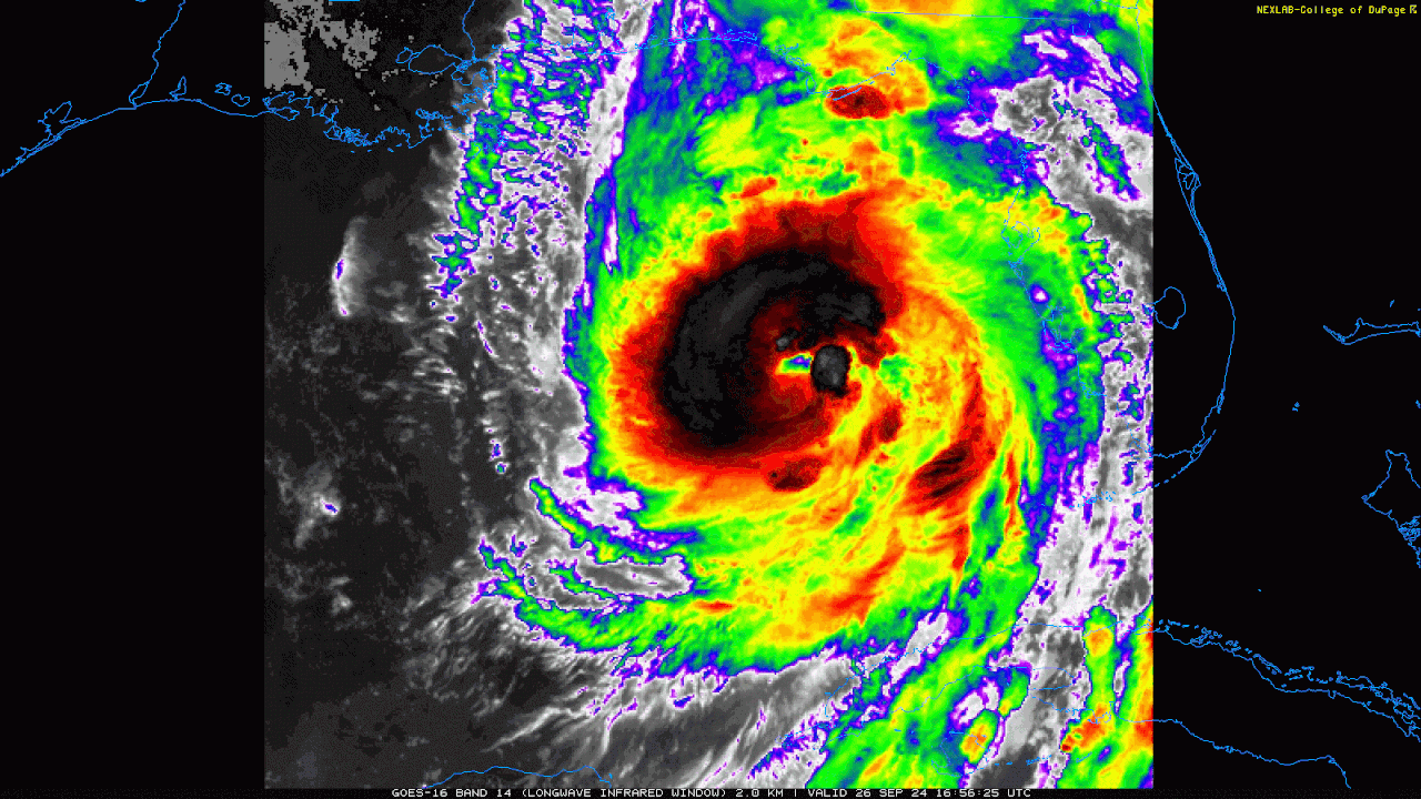
NDG wrote:Not sure if anyone mentioned how wide Helene's eye currently is, crazy!
G. Eye Shape & Diameter: Circular with a diameter of 55 nautical miles (63 statute miles)
Hoaaa?!!
1 likes
Andy D
(For official information, please refer to the NHC and NWS products.)
(For official information, please refer to the NHC and NWS products.)
-
Kingarabian

- S2K Supporter

- Posts: 16338
- Joined: Sat Aug 08, 2009 3:06 am
- Location: Honolulu, Hawaii
Re: ATL: HELENE - Hurricane - Discussion
Per Dvorak, its satellite appearance could support cat 3 status very soon.
3 likes
RIP Kobe Bryant
-
BIFF_THE_UNRULY
- Tropical Storm

- Posts: 143
- Joined: Fri Jun 28, 2024 2:12 pm
Re: ATL: HELENE - Hurricane - Discussion
Hypercane_Kyle wrote:Travorum wrote:Hypercane_Kyle wrote:
I always hate it when I see posts like this... not that we're not grateful for the storm missing Tampa again, but really tempting fate for the next storm.
Hard agree on this, especially when we're looking at another potential gulf storm as early as next weekend. And even with Helene, I don't think the people in Tampa getting up to 8 feet of surge are going to feel like they're "winning."
Yeah it really builds complacency, same mentality New Orleans had about their levees and storms missing them.
No it doesnt. Our time will come when it comes. Everyone here took Ian serouisly before it cut hard right.
1 likes

Re: ATL: HELENE - Hurricane - Discussion
I hope the eastward movement is just a wobble and not an indication of a different trend, or my preps here in Orlando are going to come up a bit short. 
0 likes
-
FLpanhandle91

- Category 5

- Posts: 1039
- Age: 34
- Joined: Mon Sep 13, 2010 3:50 pm
- Location: Fort Walton Beach, FL
Re: ATL: HELENE - Hurricane - Discussion
Fresh -80s in the eastern and northwestern eyewall. Cat 4 is very much on the table in my opinion. Best she's looked by a mile right now.
10 likes

Re: ATL: HELENE - Hurricane - Discussion
Upper level steering low to the north is starting to back off to the west.
That is probably why the forecast track starts curving west near landfall.
https://www.tropicaltidbits.com/sat/sat ... uct=wv_mid
That is probably why the forecast track starts curving west near landfall.
https://www.tropicaltidbits.com/sat/sat ... uct=wv_mid
0 likes

Re: ATL: HELENE - Hurricane - Discussion
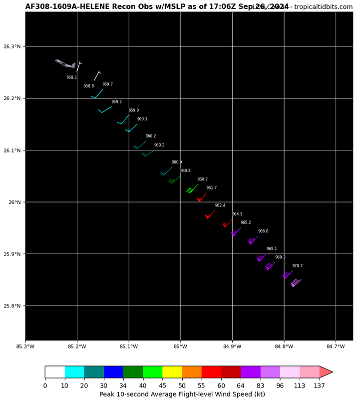
102 knot flight level wind in the SE eyewall is very impressive.
0 likes
-
tropicwatch

- Category 5
- Posts: 3426
- Age: 62
- Joined: Sat Jun 02, 2007 10:01 am
- Location: Panama City Florida
- Contact:
Re: ATL: HELENE - Hurricane - Discussion
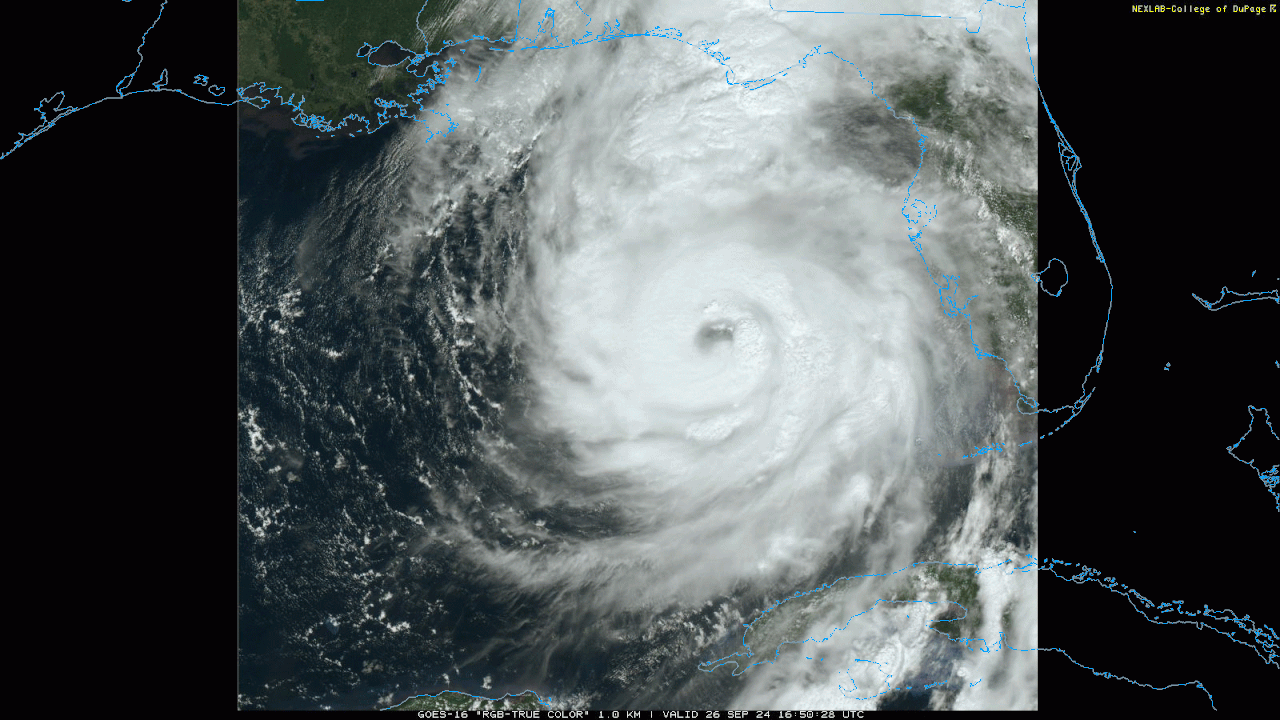
Looking at the Radar out of Tampa, it looks like the eastward movement might have stopped for the time being. Saved 48-minute loop.

2 likes
Tropicwatch
Agnes 72', Eloise 75, Elena 85', Kate 85', Charley 86', Florence 88', Beryl 94', Dean 95', Erin 95', Opal 95', Earl 98', Georges 98', Ivan 2004', Arlene 2005', Dennis 2005', Ida 2009' Debby 2012' Irma 2017' Michael 2018'
Agnes 72', Eloise 75, Elena 85', Kate 85', Charley 86', Florence 88', Beryl 94', Dean 95', Erin 95', Opal 95', Earl 98', Georges 98', Ivan 2004', Arlene 2005', Dennis 2005', Ida 2009' Debby 2012' Irma 2017' Michael 2018'
Re: ATL: HELENE - Hurricane - Discussion
MGC wrote:Eye should clear out in the next couple of hours. Expect continued intensification with possible RI if deep convection can finally wrap. Hurricane has been plagued by dry air intrusion lets hope that continues. I think the probability has diminished but is still possible. Should landfall as strong Cat-3 not the Cat-4 I was fearing. Surge will be major issue. Helene will be the Nature's Coast's Katrina. Hwy 98 will likely be washed away in areas. Small towns along the coast obliterated.....another Mexico Beach......MGC
I don't know the particular heights and varying distance of 98 to the coastline, but I am familiar with that part of 98 where it veers south toward Medart and north towards Tally. Do you think 98 will be under water just east of there between St. Marks and there (between St. Marks & where 319 intersects 98 to Tally)?
0 likes
Andy D
(For official information, please refer to the NHC and NWS products.)
(For official information, please refer to the NHC and NWS products.)
-
ElectricStorm

- Category 5
- Posts: 5125
- Age: 25
- Joined: Tue Aug 13, 2019 11:23 pm
- Location: Norman, OK
Re: ATL: HELENE - Hurricane - Discussion
That's really the first time I've seen it mix out a dry slot that quickly and prevent it from penetrating the core thanks to that huge tower that just went up. Now we'll see if we start getting some bigger pressure falls
5 likes
B.S Meteorology, University of Oklahoma '25
Please refer to the NHC, NWS, or SPC for official information.
Please refer to the NHC, NWS, or SPC for official information.
-
Hypercane_Kyle

- Category 5
- Posts: 3465
- Joined: Sat Mar 07, 2015 7:58 pm
- Location: Cape Canaveral, FL
Re: ATL: HELENE - Hurricane - Discussion
BIFF_THE_UNRULY wrote:Hypercane_Kyle wrote:Travorum wrote:
Hard agree on this, especially when we're looking at another potential gulf storm as early as next weekend. And even with Helene, I don't think the people in Tampa getting up to 8 feet of surge are going to feel like they're "winning."
Yeah it really builds complacency, same mentality New Orleans had about their levees and storms missing them.
No it doesnt. Our time will come when it comes. Everyone here took Ian serouisly before it cut hard right.
I lived in Hillsborough county during Ian and that was not what I saw. The fact we see posts on here saying "Tampa will never get a hurricane again" is proof enough.
Last edited by Hypercane_Kyle on Thu Sep 26, 2024 12:09 pm, edited 1 time in total.
0 likes
My posts are my own personal opinion, defer to the National Hurricane Center (NHC) and other NOAA products for decision making during hurricane season.

Re: ATL: HELENE - Hurricane - Discussion
Now there are two VHTs popping/rotating around the eye, one in the W quad and one in the N/NW.
4 likes
Irene '11 Sandy '12 Hermine '16 5/15/2018 Derecho Fay '20 Isaias '20 Elsa '21 Henri '21 Ida '21
I am only a meteorology enthusiast who knows a decent amount about tropical cyclones. Look to the professional mets, the NHC, or your local weather office for the best information.
I am only a meteorology enthusiast who knows a decent amount about tropical cyclones. Look to the professional mets, the NHC, or your local weather office for the best information.

-
FLpanhandle91
- Category 5
- Posts: 1039
- Age: 34
- Joined: Mon Sep 13, 2010 3:50 pm
- Location: Fort Walton Beach, FL
-
InfernoFlameCat

- Category 5
- Posts: 2127
- Age: 22
- Joined: Mon Dec 14, 2020 10:52 am
- Location: Buford, GA
Re: ATL: HELENE - Hurricane - Discussion
Travorum wrote:958.3mb extrap so far this pass.
She has resumed strengthening. And it appears at a rather quick pace as well.
2 likes
I am by no means a professional. DO NOT look at my forecasts for official information or make decisions based on what I post.
Goal: to become a registered expert over tropical and subtropical cyclones.
Goal: to become a registered expert over tropical and subtropical cyclones.
Re: ATL: HELENE - Hurricane - Discussion
tropicwatch wrote:Looking at the Radar out of Tampa, it looks like the eastward movement might have stopped for the time being. Saved 48-minute loop.
https://tropicwatch.info/heleneradar092620241700z.gif
I'm just amazed at the degree of sinking air around this storm. Far drier conditions then the extent of east semicircle developing rain bands (over land or water) that I would have expected thus far. Fair amount more moisture well southeast of the core with heavy precip still over Cuba.
1 likes
Andy D
(For official information, please refer to the NHC and NWS products.)
(For official information, please refer to the NHC and NWS products.)
-
cycloneye

- Admin

- Posts: 149146
- Age: 69
- Joined: Thu Oct 10, 2002 10:54 am
- Location: San Juan, Puerto Rico
Re: ATL: HELENE - Hurricane - Discussion
Drops from that 962 mbs that was for a while.
Minimum Extrap. Pressure: 958.3mb at 17:06z
1 likes
Visit the Caribbean-Central America Weather Thread where you can find at first post web cams,radars
and observations from Caribbean basin members Click Here
and observations from Caribbean basin members Click Here
Re: ATL: HELENE - Hurricane - Discussion
I’m in South Tampa by the water and It’s completed dry in here. Even though gusts are consistently and pretty strong 35-45 mph.
0 likes
Who is online
Users browsing this forum: No registered users and 28 guests