

ATL: MILTON - Post-Tropical - Discussion
Moderator: S2k Moderators
-
weeniepatrol

- Category 5

- Posts: 1339
- Joined: Sat Aug 22, 2020 5:30 pm
- Location: WA State

-
weeniepatrol
- Category 5
- Posts: 1339
- Joined: Sat Aug 22, 2020 5:30 pm
- Location: WA State

-
FLLurker32
- Tropical Storm

- Posts: 245
- Joined: Mon Aug 29, 2016 10:31 am
Re: ATL: MILTON - Hurricane - Discussion
I went back to look at the cone changes over the past several days vs. realized track. NHC has thus far been using every bit of that average track variation. Example: We were within 24 hours to have somewhat of a track that got this close to the Yucatan.
If this type of variance continued we could still see a 50+ mile or so landfall track shift between now and Thurs AM.
If this type of variance continued we could still see a 50+ mile or so landfall track shift between now and Thurs AM.
0 likes
Heather

Re: RE: Re: ATL: MILTON - Hurricane - Discussion: 180 mph / 899 mbs
jlauderdal wrote:Dennis Phillips was showing some very moderate wind speeds.dukeblue219 wrote:Lightning48 wrote:Our local Met just mentioned in the Tampa Bay Area that expects winds to max out in the mid 60’s due to weakening. What’s your thoughts?
My thought is that you misheard or misunderstood something.
I was also watching Denis and I do not recall him saying that - In the live streaming segment, he did say the maximum winds will be in a very small area and that most of the Tampa Bay area will get lesser hurricane force winds and tropical storm force winds. One of the graphics did seem off when it comes to wind speed. Perhaps that is where the confusion was? Sometimes the graphics do not always get updated correctly.
0 likes

Re: ATL: MILTON - Hurricane - Discussion
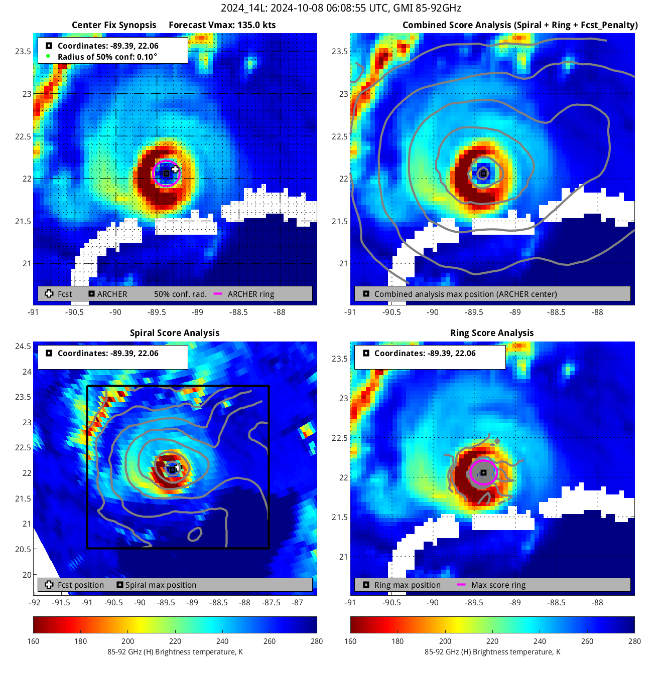
Milton is now past its lowest point in terms of IR presentation. Raw T# dipped to 5.5 roughly 2.5 hours ago and is now back up to 6.1. The CDO is also cooling again and, at -78.9C, is once again the coldest CDO on record in the GOM besides Milton's record from a few hours ago of course. I expect the next recon mission to find Milton at 135 - 140 kt again and a pressure equal or slightly lower than the previous mission when it left.
2 likes


Re: ATL: MILTON - Hurricane - Discussion
Continuous lightning in the core and very high precipitation rate.
https://rammb-data.cira.colostate.edu/t ... 080613.png
Also, another round of ionospheric heating is in store today.
https://solarham.com/globald.htm
https://solarham.com/kp.htm
Very likely another RI event is forthcoming.
https://rammb-data.cira.colostate.edu/t ... 080613.png
Also, another round of ionospheric heating is in store today.
https://solarham.com/globald.htm
https://solarham.com/kp.htm
Very likely another RI event is forthcoming.
2 likes
Re: ATL: MILTON - Hurricane - Discussion
Looks like the EPAC feed has been cutoff.
https://tropic.ssec.wisc.edu/real-time/ ... anim=html5
The W Carib feed will kick in once Milton clears the Yucatan.
Also, will be riding the hottest part of the Lopp Current then.
https://tropic.ssec.wisc.edu/real-time/ ... anim=html5
The W Carib feed will kick in once Milton clears the Yucatan.
Also, will be riding the hottest part of the Lopp Current then.
1 likes
Re: ATL: MILTON - Hurricane - Discussion
Higher CAPE air is now working its way into the east GOM from the south.
Seeing 4000 coming in.
Seeing 4000 coming in.
1 likes
Re: ATL: MILTON - Hurricane - Discussion
Sanibel wrote:Cooler upwelling SST's off north Yucatan.
Do you have a link for a real-time OHC map?
0 likes
-
johngaltfla

- Category 5
- Posts: 2073
- Joined: Sun Jul 10, 2005 9:17 pm
- Location: Sarasota County, FL
- Contact:
Re: ATL: MILTON - Hurricane - Discussion
Looking at the overnight models, consensus seems to be the eye will pass somewhere between Venice, FL and Treasure Island/Madeira Beach, FL. Folks, if you haven't bugged out off the barrier islands remember, the bridges will close before noon tomorrow.
Get your preps finalized today and good luck to all my peeps on the Suncoast and in the Tampa Bay area.
Get your preps finalized today and good luck to all my peeps on the Suncoast and in the Tampa Bay area.
7 likes
Re: ATL: MILTON - Hurricane - Discussion
The NHC is using the strongest terms of describe the risk Milton poses to Florida in their latest advisory.
Milton has the potential to be one of the most destructive hurricanes on record for west-central Florida.
6 likes
-
johngaltfla
- Category 5
- Posts: 2073
- Joined: Sun Jul 10, 2005 9:17 pm
- Location: Sarasota County, FL
- Contact:
Re: ATL: MILTON - Hurricane - Discussion
kevin wrote:The NHC is using the strongest terms of describe the risk Milton poses to Florida in their latest advisory.Milton has the potential to be one of the most destructive hurricanes on record for west-central Florida.
No disrespect to the NHC but whoever wrote that is the master of understatement.
I honestly do not think people realize how overbuilt and expensively built this region is. I love my native home, but we all knew there would be a reckoning.
That discussion is for another time. Right now it's about preserving life and urging the insanely stubborn in Evacuation Zones A & B to get out.
4 likes
Re: ATL: MILTON - Hurricane - Discussion
johngaltfla wrote:kevin wrote:The NHC is using the strongest terms of describe the risk Milton poses to Florida in their latest advisory.Milton has the potential to be one of the most destructive hurricanes on record for west-central Florida.
No disrespect to the NHC but whoever wrote that is the master of understatement.
I honestly do not think people realize how overbuilt and expensively built this region is. I love my native home, but we all knew there would be a reckoning.
That discussion is for another time. Right now it's about preserving life and urging the insanely stubborn in Evacuation Zones A & B to get out.
And C in the Tampa Bay region.
2 likes
-
johngaltfla
- Category 5
- Posts: 2073
- Joined: Sun Jul 10, 2005 9:17 pm
- Location: Sarasota County, FL
- Contact:
Re: ATL: MILTON - Hurricane - Discussion
caneman wrote:johngaltfla wrote:kevin wrote:The NHC is using the strongest terms of describe the risk Milton poses to Florida in their latest advisory.Milton has the potential to be one of the most destructive hurricanes on record for west-central Florida.
No disrespect to the NHC but whoever wrote that is the master of understatement.
I honestly do not think people realize how overbuilt and expensively built this region is. I love my native home, but we all knew there would be a reckoning.
That discussion is for another time. Right now it's about preserving life and urging the insanely stubborn in Evacuation Zones A & B to get out.
And C in the Tampa Bay region.
C will be today down here also. I'm pretty confident based on the models in the track now so the last two panels go up today.
For my friends here on the Suncoast, if you seen an elderly person, try to help them if they need it. A lot of them can not put up their own plywood or panels on their own.
2 likes
-
Stormgodess

- Category 1

- Posts: 316
- Joined: Mon Sep 14, 2020 1:31 am
Re: ATL: MILTON - Hurricane - Discussion
caneman wrote:johngaltfla wrote:kevin wrote:The NHC is using the strongest terms of describe the risk Milton poses to Florida in their latest advisory.Milton has the potential to be one of the most destructive hurricanes on record for west-central Florida.
No disrespect to the NHC but whoever wrote that is the master of understatement.
I honestly do not think people realize how overbuilt and expensively built this region is. I love my native home, but we all knew there would be a reckoning.
That discussion is for another time. Right now it's about preserving life and urging the insanely stubborn in Evacuation Zones A & B to get out.
And C in the Tampa Bay region.
Contraflow really needs to be implemented in the Northern part of the state, with one lane south for Tankers and emergency vehicles. The traffic is a nightmare and gas stations empty
0 likes
-
johngaltfla
- Category 5
- Posts: 2073
- Joined: Sun Jul 10, 2005 9:17 pm
- Location: Sarasota County, FL
- Contact:
Re: ATL: MILTON - Hurricane - Discussion
Stormgodess wrote:caneman wrote:johngaltfla wrote:
No disrespect to the NHC but whoever wrote that is the master of understatement.
I honestly do not think people realize how overbuilt and expensively built this region is. I love my native home, but we all knew there would be a reckoning.
That discussion is for another time. Right now it's about preserving life and urging the insanely stubborn in Evacuation Zones A & B to get out.
And C in the Tampa Bay region.
Contraflow really needs to be implemented in the Northern part of the state, with on lane south for Tankers and emergency vehicles. The traffic is a nightmare and gas stations empty
Actually our DOT did a very in depth study on this.
Contraflow actually made the traffic worse and obstructed necessary supplies coming into to the regions impacted for pre and post storm preparation.
Kudos to them for actually analyzing every storm since Andrew and validating the findings.
11 likes
Who is online
Users browsing this forum: No registered users and 14 guests