
Still no sign of that eye clearing out. If anything, its IR presentation looks a little worse than a few hours ago. Perhaps it’s not able to ventilate as well as before. We’ll see what happens when it moves closer to the Yucatan Channel later today.
ATL: MILTON - Post-Tropical - Discussion
Moderator: S2k Moderators
Re: ATL: MILTON - Hurricane - Discussion
Still no sign of that eye clearing out. If anything, its IR presentation looks a little worse than a few hours ago. Perhaps it’s not able to ventilate as well as before. We’ll see what happens when it moves closer to the Yucatan Channel later today.
0 likes
Irene '11 Sandy '12 Hermine '16 5/15/2018 Derecho Fay '20 Isaias '20 Elsa '21 Henri '21 Ida '21
I am only a meteorology enthusiast who knows a decent amount about tropical cyclones. Look to the professional mets, the NHC, or your local weather office for the best information.
I am only a meteorology enthusiast who knows a decent amount about tropical cyclones. Look to the professional mets, the NHC, or your local weather office for the best information.
-
jlauderdal
- S2K Supporter

- Posts: 7240
- Joined: Wed May 19, 2004 5:46 am
- Location: NE Fort Lauderdale
- Contact:
Re: ATL: MILTON - Hurricane - Discussion
GCANE wrote:Higher CAPE air is now working its way into the east GOM from the south.
Seeing 4000 coming in.
The low that has been sitting over the eastern gulf is on the move with a lemon designation for future development, its a clear out in advance of Milt. No shortage of CAPE moving forward. I had over 10 inches of rain from this feature at my place which had zilch to do with Milt other than being in the same region. Take this one seriously and do not give up, not to give false hope but we have seen many hurricanes underperform on approach so there is that and this is a "small" system so the chances of a ramp down are there, ramp up is also possible especially later today as the system finds a very favorable setup including the loop current. A track S of Tampa is looking more likely so thats "good". Evacuate if you are in the zone, you only have to go a few miles but you are welcome to come to SE FL, I would stay as close as possible without getting surge. Long-range evacuations are entirely unnecessary.
DO NOT TRY AND BE A HERO WITH SURGE, THE CHASERS RUN FROM IT!!
5 likes
-
johngaltfla

- Category 5

- Posts: 2073
- Joined: Sun Jul 10, 2005 9:17 pm
- Location: Sarasota County, FL
- Contact:
Re: ATL: MILTON - Hurricane - Discussion
jlauderdal wrote:GCANE wrote:Higher CAPE air is now working its way into the east GOM from the south.
Seeing 4000 coming in.
The low that has been sitting over the eastern gulf is on the move with a lemon designation for future development, its a clear out in advance of Milt. No shortage of CAPE moving forward. I had over 10 inches of rain from this feature at my place which had zilch to do with Milt other than being in the same region. Take this one seriously and do not give up, not to give false hope but we have seen many hurricanes underperform on approach so there is that and this is a "small" system so the chances of a ramp down are there, ramp up is also possible especially later today as the system finds a very favorable setup including the loop current. A track S of Tampa is looking more likely so thats "good". Evacuate if you are in the zone, you only have to go a few miles but you are welcome to come to SE FL, I would stay as close as possible without getting surge. Long-range evacuations are entirely unnecessary.
DO NOT TRY AND BE A HERO WITH SURGE, THE CHASERS RUN FROM IT!!
It's "good" unless you're in that track jl, lol. But we're as ready as we can be for it. Thankfully I'm inland and we're evacuating our elderly relatives this afternoon from the "C" zones.
2 likes

Re: ATL: MILTON - Hurricane - Discussion
Recon descending to operational altitude and about to enter Milton. Very curious what they will find, not only Milton's intensity but especially the status of the eye(wall).
0 likes
-
MEANINGLESS_NUMBERS
- Category 2

- Posts: 503
- Joined: Mon Nov 02, 2020 1:43 pm
Re: ATL: MILTON - Hurricane - Discussion
kevin wrote:Recon descending to operational altitude and about to enter Milton. Very curious what they will find, not only Milton's intensity but especially the status of the eye(wall).
Satellite presentation continues to degrade. Can’t imagine they will find the re-strengthening that NHC predicted.
0 likes
Emily '87, Felix '95, Gert '99, Fabian '03, Humberto '19, Paulette '20, Teddy '20, Fiona '22, Lee '23, Ernesto '24, Humberto/Imelda '25
Re: ATL: MILTON - Hurricane - Discussion
weeniepatrol wrote:https://i.ibb.co/rxj7vHq/Milton10-07-24.png
Where can I find the raw data points? I want to see if I can plot a best-fit curve that predicts what the minimum pressure may have been.
1 likes
Irene '11 Sandy '12 Hermine '16 5/15/2018 Derecho Fay '20 Isaias '20 Elsa '21 Henri '21 Ida '21
I am only a meteorology enthusiast who knows a decent amount about tropical cyclones. Look to the professional mets, the NHC, or your local weather office for the best information.
I am only a meteorology enthusiast who knows a decent amount about tropical cyclones. Look to the professional mets, the NHC, or your local weather office for the best information.
-
grapealcoholic
- Category 2
- Posts: 703
- Joined: Tue Aug 10, 2021 3:26 pm
Re: ATL: MILTON - Hurricane - Discussion
MEANINGLESS_NUMBERS wrote:kevin wrote:Recon descending to operational altitude and about to enter Milton. Very curious what they will find, not only Milton's intensity but especially the status of the eye(wall).
Satellite presentation continues to degrade. Can’t imagine they will find the re-strengthening that NHC predicted.
Low level structure is in tact. IR will follow in time
2 likes
Re: ATL: MILTON - Hurricane - Discussion
MEANINGLESS_NUMBERS wrote:kevin wrote:Recon descending to operational altitude and about to enter Milton. Very curious what they will find, not only Milton's intensity but especially the status of the eye(wall).
Satellite presentation continues to degrade. Can’t imagine they will find the re-strengthening that NHC predicted.
I disagree. It's not perfect by any means, but if anything I'd say satellite presentation has improved in the last 30 minutes. I don't think they'll find a cat 5, but I think Milton is already past its worst look.
30 minutes ago

Now

9 likes
-
dukeblue219
- S2K Supporter
- Posts: 556
- Joined: Fri Sep 30, 2016 3:52 pm
Re: ATL: MILTON - Hurricane - Discussion
MEANINGLESS_NUMBERS wrote:
Satellite presentation continues to degrade. Can’t imagine they will find the re-strengthening that NHC predicted.
Not sure I agree:
5 likes

Re: ATL: MILTON - Hurricane - Discussion
Milton seems to have slowed down a lot in the past few hours.
0 likes
Re: ATL: MILTON - Hurricane - Discussion
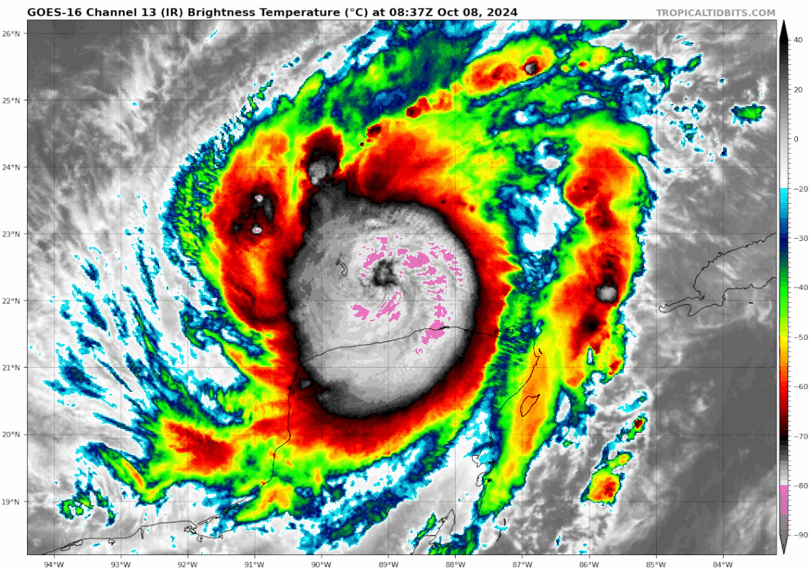
Eye temperature up to -60C, might start to clear out soon. In other words great time for recon.
0 likes
-
Nehalenniawx
- Tropical Wave

- Posts: 1
- Joined: Sat Oct 05, 2024 1:20 pm
Re: ATL: MILTON - Hurricane - Discussion
aspen wrote:weeniepatrol wrote:https://i.ibb.co/rxj7vHq/Milton10-07-24.png
Where can I find the raw data points? I want to see if I can plot a best-fit curve that predicts what the minimum pressure may have been.
In the Milton recon thread,
also somewhere in this archive:
https://www.nhc.noaa.gov/archive/recon/2024
1 likes
Re: ATL: MILTON - Hurricane - Discussion
Starting to generate another pink ring. The pink ring covered a quarter of the CDO 30 minutes ago and now its already past the halfway mark.
2 likes


-
grapealcoholic
- Category 2
- Posts: 703
- Joined: Tue Aug 10, 2021 3:26 pm
-
dukeblue219
- S2K Supporter
- Posts: 556
- Joined: Fri Sep 30, 2016 3:52 pm

-
dukeblue219
- S2K Supporter
- Posts: 556
- Joined: Fri Sep 30, 2016 3:52 pm
Re: ATL: MILTON - Hurricane - Discussion
First recon pass, 926.7 mb extrapolated with 21 kt winds nearby. So far 126 kt FL winds on the western side.
0 likes
Who is online
Users browsing this forum: No registered users and 14 guests