ATL: BERYL - Post-Tropical - Discussion

Moderator: S2k Moderators

Message
Author
sphelps8681
Category 2
Category 2
Posts: 785
Joined: Thu Aug 16, 2007 5:37 pm
Location: Somewhere over the rainbow

Re: ATL: BERYL - Tropical Storm - Discussion

#2941 Postby sphelps8681 » Fri Jul 05, 2024 4:02 pm

jaguars_22 wrote:Maybe they don’t know what to do either?!!!! Where is wxman??


His job as a weatherman. He is a busy man dealing with clients. I am sure if you pay him he would be glad to let you know.
5 likes   

User avatar
GCANE
S2K Supporter
S2K Supporter
Posts: 11453
Joined: Mon Oct 22, 2007 8:03 am

Re: ATL: BERYL - Tropical Storm - Discussion

#2942 Postby GCANE » Fri Jul 05, 2024 4:02 pm

ULL does look like its moistening up a bit.
Could weaken here in the next 24 hrs.
Would be a big boost for Beryl's health.
2 likes   

zzzh
Category 3
Category 3
Posts: 834
Joined: Thu Sep 02, 2021 1:13 pm

Re: ATL: BERYL - Tropical Storm - Discussion

#2943 Postby zzzh » Fri Jul 05, 2024 4:03 pm

aspen wrote:

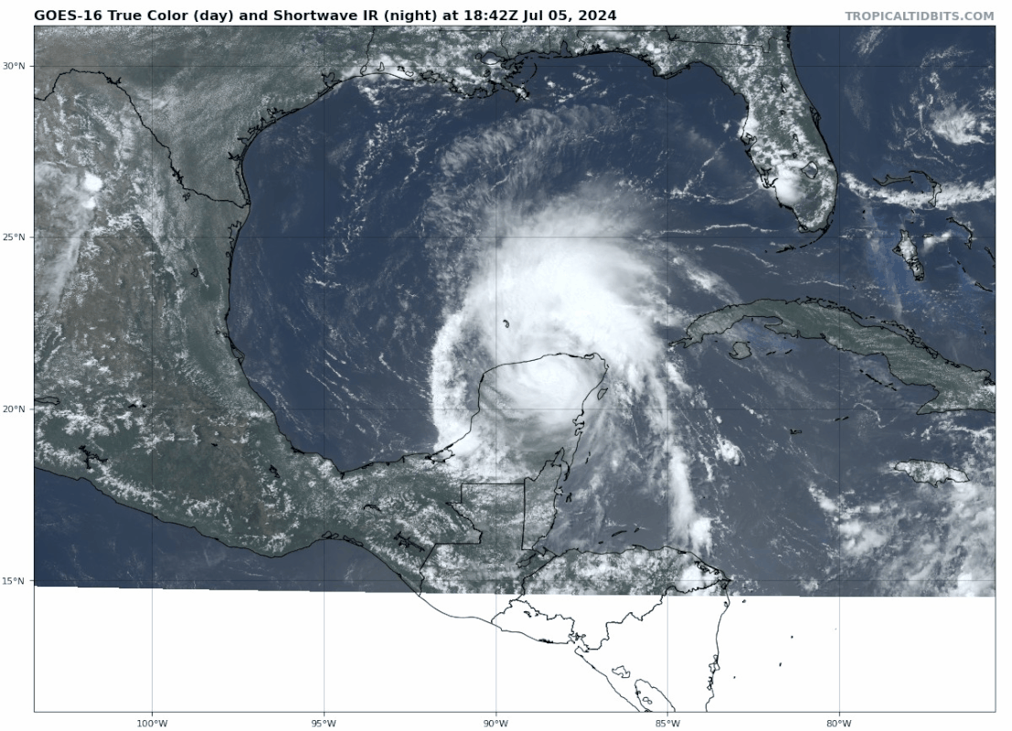
Oof, the inner core from the previous pass is basically gone. It’ll probably have to start from scratch.

Note that the TROPICS 6 TMS is the microwave at 208GHz, while AMSR2 is at 89GHz, they detect different levels.
1 likes   

hcane27
Tropical Storm
Tropical Storm
Posts: 231
Joined: Tue Jan 31, 2006 7:33 pm

Re: ATL: BERYL - Tropical Storm - Discussion

#2944 Postby hcane27 » Fri Jul 05, 2024 4:03 pm

Not confident that Louisiana is out of the woods yet
4 likes   

User avatar
InfernoFlameCat
Category 5
Category 5
Posts: 2102
Age: 22
Joined: Mon Dec 14, 2020 10:52 am
Location: Buford, GA

Re: ATL: BERYL - Tropical Storm - Discussion

#2945 Postby InfernoFlameCat » Fri Jul 05, 2024 4:05 pm

Beryl looks like it's heading due north?! I don't like the way this looks at all.
1 likes   
I am by no means a professional. DO NOT look at my forecasts for official information or make decisions based on what I post.

Goal: to become a registered expert over tropical and subtropical cyclones.

User avatar
Hurrilurker
Category 2
Category 2
Posts: 719
Joined: Mon Jun 09, 2003 3:32 pm
Location: San Francisco, CA

Re: ATL: BERYL - Tropical Storm - Discussion

#2946 Postby Hurrilurker » Fri Jul 05, 2024 4:07 pm

Stormcenter wrote:It’s still moving WNW…..I need to go to my eye doctor then if that’s the case.

Yeah it definitely looks like NNW to me but we need recon to confirm what's really going on in there. Maybe it's also possible friction from land interaction on the south side will nudge it back west a bit as it spins off?
3 likes   

User avatar
Teban54
Category 5
Category 5
Posts: 3168
Joined: Sat May 19, 2018 1:19 pm

Re: ATL: BERYL - Tropical Storm - Discussion

#2947 Postby Teban54 » Fri Jul 05, 2024 4:10 pm

IcyTundra wrote:
Stormgodess wrote:
ColdFusion wrote:


Sincere question.

If the latest forecast track lies west of the various consensus models, and even say it may be necessary to adjust it tonight... why wouldn't they go ahead and adjust it now?


NHC doesn't like to shift the track too much in 1 advisory. They prefer to slowly shift their track.

To add more context, sometimes trends in model tracks do pause or even reverse at lead times similar to right now. Ian 2022 was an example, where the NHC's first advisory "nailed" the landfall point near Fort Myers, but gradually moved up to Tampa and Cedar Key when later model runs shifted west, only to gradually move back when the model trends reversed. In some other cases, following the models or TVCN precisely may result in the official forecast track oscillating with every advisory, which isn't desirable for public communications.

Of course, these relatively slow adjustments sometimes do result in undesirable situations and critics. Ian is again a good example here, as NHC's official, "deterministic" forecast was still showing disastrous outcomes for Tampa when most models (and Storm2K) were already further south and sparing it a hit.
4 likes   

User avatar
Hurrilurker
Category 2
Category 2
Posts: 719
Joined: Mon Jun 09, 2003 3:32 pm
Location: San Francisco, CA

Re: ATL: BERYL - Tropical Storm - Discussion

#2948 Postby Hurrilurker » Fri Jul 05, 2024 4:10 pm

Considering its location and likely track, don't be surprised to see gas prices rise in the coming months.
3 likes   

Frank P
S2K Supporter
S2K Supporter
Posts: 2772
Joined: Fri Aug 29, 2003 10:52 am
Location: Biloxi Beach, Ms
Contact:

Re: ATL: BERYL - Tropical Storm - Discussion

#2949 Postby Frank P » Fri Jul 05, 2024 4:12 pm

Hurrilurker wrote:
Stormcenter wrote:It’s still moving WNW…..I need to go to my eye doctor then if that’s the case.

Yeah it definitely looks like NNW to me but we need recon to confirm what's really going on in there. Maybe it's also possible friction from land interaction on the south side will nudge it back west a bit as it spins off?

hard to believe it was move wnw as it tracked across the Yutacan... sometimes seeing is believing. I usually defer (90%) of the time to the NHC but .... makes ya wonder
4 likes   

User avatar
cycloneye
Admin
Admin
Posts: 143917
Age: 68
Joined: Thu Oct 10, 2002 10:54 am
Location: San Juan, Puerto Rico

Re: ATL: BERYL - Tropical Storm - Discussion

#2950 Postby cycloneye » Fri Jul 05, 2024 4:15 pm

1 likes   
Visit the Caribbean-Central America Weather Thread where you can find at first post web cams,radars
and observations from Caribbean basin members Click Here

crimi481
Category 2
Category 2
Posts: 602
Joined: Thu Sep 09, 2004 4:47 pm

Re: ATL: BERYL - Tropical Storm - Discussion

#2951 Postby crimi481 » Fri Jul 05, 2024 4:15 pm

On WV loop - notice the clouds/weather is moving to the NE. This may influence Beryl in time.
Mexico landfall may end up Fl panhandle landfall
0 likes   

Anti-freeze
Tropical Storm
Tropical Storm
Posts: 109
Joined: Tue Jan 02, 2024 8:26 pm

Re: ATL: BERYL - Tropical Storm - Discussion

#2952 Postby Anti-freeze » Fri Jul 05, 2024 4:17 pm

4 likes   

User avatar
Teban54
Category 5
Category 5
Posts: 3168
Joined: Sat May 19, 2018 1:19 pm

Re: ATL: BERYL - Tropical Storm - Discussion

#2953 Postby Teban54 » Fri Jul 05, 2024 4:18 pm

Looks pretty good by TS-leaving-Yucatan standards, especially given how badly sheared it had looked for multiple days. Let's hope the modeled dry air intrusion happens in the short term and stops it from improving even further.
Image
0 likes   

User avatar
Stormgodess
Category 1
Category 1
Posts: 301
Joined: Mon Sep 14, 2020 1:31 am

Re: ATL: BERYL - Tropical Storm - Discussion

#2954 Postby Stormgodess » Fri Jul 05, 2024 4:20 pm

InfernoFlameCat wrote:Beryl looks like it's heading due north?! I don't like the way this looks at all.


Ok.

So it's NOT just me
:double:
0 likes   

tolakram
Admin
Admin
Posts: 19990
Age: 61
Joined: Sun Aug 27, 2006 8:23 pm
Location: Florence, KY (name is Mark)

Re: ATL: BERYL - Tropical Storm - Discussion

#2955 Postby tolakram » Fri Jul 05, 2024 4:21 pm

I don't fully understand the ULL issue with Beryl. Right now it appears to be in a good location to help vent the storm, and it will depend how it moves.

I'm probably wrong, maybe someone can explain it.

Image
3 likes   
M a r k
- - - - -
Join us in chat: Storm2K Chatroom Invite. Android and IOS apps also available.

The posts in this forum are NOT official forecasts and should not be used as such. Posts are NOT endorsed by any professional institution or STORM2K.org. For official information and forecasts, please refer to NHC and NWS products.

USTropics
Category 5
Category 5
Posts: 2636
Joined: Sun Aug 12, 2007 3:45 am
Location: Florida State University

Re: ATL: BERYL - Tropical Storm - Discussion

#2956 Postby USTropics » Fri Jul 05, 2024 4:23 pm

IcyTundra wrote:I remember Levi saying in his update today that there is a ridge in the eastern gulf that will help determine the eastern most possible tracks. I think SW Louisiana is a stretch at this point but Beryl just loves to prove people wrong,


Congrats on 1k posts, I'm going to bust out the crayons for you :lol: . The players are 'on the board' so to speak, and we can actually monitor these in real time now. There is an edge set to how far east this can actually go, and it will be determined by how far south the trough (highlighted in blue here) over the Midwest can dig and break down the ridge (in orange) associated with the high pressure. The dashed orange lines represents where we expect our break (could be more substantial, could be less, why I dashed this area and depends on the trough). In addition, as Beryl positions itself to the northeast of the retrograding ULL (that is backing out towards the west/NE Mexico), if we have a vertically stacked/deep cyclone, this southwesterly flow will also usher it towards the north (i.e., stronger cyclones feel the influence from upper-level flow more):

Image

If we look at the latest EPS run at 48 hours, we can see the most likely edge of the ridge (as denoted by the ensemble members) is set up right over LA. The likely location of Beryl at this point is further west, and the steering flow here would pull Beryl towards the central/northeastern Texas coastline.
Image

What could cause Beryl to landfall more towards LA? If the center remerges off the Yucatan peninsula more to the east, Beryl's core remains relatively intact and quickly begins to restrengthen, and/or the trough deepens more than models are predicting, we could still see more shifts to the east.
17 likes   

User avatar
Steve
S2K Supporter
S2K Supporter
Posts: 9591
Joined: Sat Apr 05, 2003 11:41 pm
Location: Not a state-caster

Re: ATL: BERYL - Hurricane - Discussion

#2957 Postby Steve » Fri Jul 05, 2024 4:29 pm

Craters wrote:
Frank P wrote:Hard to beat the Katrina shift west with 3 days out, was pinpointing the FL panhandle and we all know how that panned out.. I remember getting a message from wxmn57 on that Friday before the storm telling me he was pretty sure that it was not going into the FL Panhandle but towards the MS and NOLA areas... I think his mother lived in Pascagoula at the time... remember it like yesterday..

It sure would be interesting to take the data from, say, five days before that shift west and let the current models run to see what their forecasts would be now relative to the ones that existed back then...


Not to stray too far off topic but it was the SW dive that prompted the “uh oh” that Friday afternoon. That’s when NHC knew it was coming farther west.
3 likes   

Frank P
S2K Supporter
S2K Supporter
Posts: 2772
Joined: Fri Aug 29, 2003 10:52 am
Location: Biloxi Beach, Ms
Contact:

Re: ATL: BERYL - Tropical Storm - Discussion

#2958 Postby Frank P » Fri Jul 05, 2024 4:31 pm

Stormgodess wrote:
InfernoFlameCat wrote:Beryl looks like it's heading due north?! I don't like the way this looks at all.


Ok.

So it's NOT just me
:double:

that is N or NNW at worse... geesh
1 likes   

bohai
Tropical Depression
Tropical Depression
Posts: 76
Age: 65
Joined: Tue Jun 02, 2020 12:57 pm
Location: Comfort, TX

Re: ATL: BERYL - Tropical Storm - Discussion

#2959 Postby bohai » Fri Jul 05, 2024 4:32 pm

We used to use WXMAN for our offshore weather. Trust me with offshore leases he has his hands full advising on evacuation recommendations. Boats are often used to move personnel back and forth from offshore facilities. Not enough helicopters for everyone. Once seas get past a certain state, it becomes unsafe to transfer them from facility to boat. Helicopters, if I remember correctly, are limited to operations in winds below 30 mph. I’m n top of that all producing oil and gas wells must be shut in and secured. This also takes time , so I am sure wxman57 is pretty focused on helping those that pay him big bucks.
12 likes   

User avatar
Stormgodess
Category 1
Category 1
Posts: 301
Joined: Mon Sep 14, 2020 1:31 am

Re: ATL: BERYL - Tropical Storm - Discussion

#2960 Postby Stormgodess » Fri Jul 05, 2024 4:33 pm

USTropics wrote:
IcyTundra wrote:I remember Levi saying in his update today that there is a ridge in the eastern gulf that will help determine the eastern most possible tracks. I think SW Louisiana is a stretch at this point but Beryl just loves to prove people wrong,


Congrats on 1k posts, I'm going to bust out the crayons for you :lol: . The players are 'on the board' so to speak, and we can actually monitor these in real time now. There is an edge set to how far east this can actually go, and it will be determined by how far south the trough (highlighted in blue here) over the Midwest can dig and break down the ridge (in orange) associated with the high pressure. The dashed orange lines represents where we expect our break (could be more substantial, could be less, why I dashed this area and depends on the trough). In addition, as Beryl positions itself to the northeast of the retrograding ULL (that is backing out towards the west/NE Mexico), if we have a vertically stacked/deep cyclone, this southwesterly flow will also usher it towards the north (i.e., stronger cyclones feel the influence from upper-level flow more):

https://i.imgur.com/re87a9Y.png

If we look at the latest EPS run at 48 hours, we can see the most likely edge of the ridge (as denoted by the ensemble members) is set up right over LA. The likely location of Beryl at this point is further west, and the steering flow here would pull Beryl towards the central/northeastern Texas coastline.
https://i.imgur.com/fGRNVCv.png

What could cause Beryl to landfall more towards LA? If the center remerges off the Yucatan peninsula more to the east, Beryl's core remains relatively intact and quickly begins to restrengthen, and/or the trough deepens more than models are predicting, we could still see more shifts to the east.


I could kiss you for this post!!


Exactly the type of information weather dunces like myself need, WITH VISUALS!

:sun:

Edited to remove the jumping smilies, they were about to give me a seizure
Last edited by Stormgodess on Fri Jul 05, 2024 4:35 pm, edited 1 time in total.
13 likes   


Return to “2024”

Who is online

Users browsing this forum: No registered users and 43 guests