ATL: MILTON - Post-Tropical - Discussion
Moderator: S2k Moderators

Re: ATL: MILTON - Hurricane - Discussion: 150 mph / 929 mbs
Upgrade looks reasonable to me
2 likes
Very useful information on the Dvorak Technique --
https://severe.worldweather.wmo.int/TCF ... kBeven.pdf
https://severe.worldweather.wmo.int/TCF ... kBeven.pdf

Re: ATL: MILTON - Hurricane - Discussion: 150 mph / 929 mbs
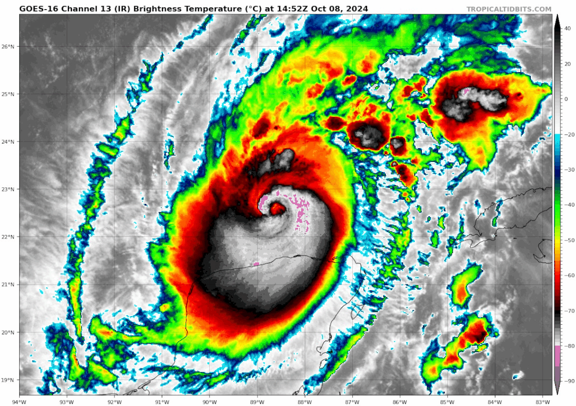
This is going to be one of the most intense nail biter storms I think I've ever seen. Not only will exact track be crucial for Tampa's surge prospects, but we also have to watch for exactly when the wind shear impinges and weakens the storm. In the worst case scenario Milton maintains strength until landfall, and comes in just North of Tampa. In that situation things would be absolutely dire. In the reverse case if it weakens a bit earlier than expected and comes in South, there will still be lots of severe impacts to someone, but a Katrina level catastrophe would be avoided.
I don't envy emergency planners and disaster responses teams here. There's already too much devastation just to the North.
I don't envy emergency planners and disaster responses teams here. There's already too much devastation just to the North.
7 likes
-
tolakram
- Admin

- Posts: 20173
- Age: 62
- Joined: Sun Aug 27, 2006 8:23 pm
- Location: Florence, KY (name is Mark)
Re: ATL: MILTON - Hurricane - Discussion: 150 mph / 929 mbs
Xyls wrote:What direction is Milton actually going right now as doesn't appear to be much of a northern component at this time.
Should be near due east for a little while longer, then a turn toward the NE.
6 likes
M a r k
- - - - -
Join us in chat: Storm2K Chatroom Invite. Android and IOS apps also available.
The posts in this forum are NOT official forecasts and should not be used as such. Posts are NOT endorsed by any professional institution or STORM2K.org. For official information and forecasts, please refer to NHC and NWS products.

Re: ATL: MILTON - Hurricane - Discussion: 150 mph / 929 mbs
With that pass, a blend of FL winds and SFMR would suggest an intensity of 135 kts/155 mph.
3 likes
-
Sailingtime
- Tropical Low

- Posts: 38
- Joined: Thu Aug 29, 2019 7:02 pm
Re: ATL: MILTON - Hurricane - Discussion: 150 mph / 929 mbs
Highteeld wrote:Remember all the complaints just 3 weeks ago saying this season was a total bust?
Don't think anyone who lives along the coastal areas would ever say that. Oh, for sure, the storms are fun to track but to be honest, when a storm is coming in over your house, you really are not even concerned about the records or what the latest drop sounding shows. It becomes all too real when you live in an impacted area. The season was very "slow" which was fantastic. We all know, all too well that mother nature does what mother nature does. Hang tight and stay safe Florida!
5 likes
-
Hypercane_Kyle

- Category 5

- Posts: 3465
- Joined: Sat Mar 07, 2015 7:58 pm
- Location: Cape Canaveral, FL
Re: ATL: MILTON - Hurricane - Discussion: 150 mph / 929 mbs

9 likes
My posts are my own personal opinion, defer to the National Hurricane Center (NHC) and other NOAA products for decision making during hurricane season.
-
Sciencerocks
- Category 5
- Posts: 10181
- Age: 40
- Joined: Thu Jul 06, 2017 1:51 am
Re: ATL: MILTON - Hurricane - Discussion: 150 mph / 929 mbs
165600 2225N 08811W 6952 02602 9389 +130 +098 211110 129 143 023 00
165630 2224N 08810W 6972 02641 9480 +104 +102 211141 145 142 026 00
165700 2223N 08809W 6966 02700 9541 +097 +078 212143 145 133 052 00
145 knts flight level = 130.5 knts with 143 knt smrf. I'd mix these and get 135 knts. Closing on cat5 again.
165630 2224N 08810W 6972 02641 9480 +104 +102 211141 145 142 026 00
165700 2223N 08809W 6966 02700 9541 +097 +078 212143 145 133 052 00
145 knts flight level = 130.5 knts with 143 knt smrf. I'd mix these and get 135 knts. Closing on cat5 again.
7 likes
-
drewschmaltz
- S2K Supporter

- Posts: 351
- Joined: Thu Aug 27, 2015 8:19 pm
Re: ATL: MILTON - Hurricane - Discussion: 150 mph / 929 mbs
Due to the steering we've heard stronger north. Pretty cool if you think about what we saw in the short term. Storm weakened and it dipped south. Strengthening now and leveling out. May or may not be what's really happened. But, if it is, it goes to show how and why the longer range forecasts are moving north and south. So, if we see a deepening beyond forecast I think the track will start lifting N again. Maybe?
0 likes
I HAVE ABSOLUTELY NO IDEA WHAT I'M TALKING ABOUT. PLEASE CONSULT SOMEONE WHO DOES. START WITH THE NHC. ALL POSTS ARE FOR ENTERTAINMENT PURPOSES ONLY.
-
cheezyWXguy

- Category 5
- Posts: 6280
- Joined: Mon Feb 13, 2006 12:29 am
- Location: Dallas, TX
Re: ATL: MILTON - Hurricane - Discussion: 150 mph / 929 mbs
Easy 135kt justification. NHC’s handling of Laura, Ida, Ian, and even Michael at their peaks suggests to me they will not pull the trigger yet. I could be wrong though, but I suspect they will not pull the trigger until 150kt+ FL winds are found
7 likes
-
TeamPlayersBlue

- Category 5
- Posts: 3524
- Joined: Tue Feb 02, 2010 1:44 am
- Location: Denver/Applewood, CO
Re: ATL: MILTON - Hurricane - Discussion: 150 mph / 929 mbs
GCANE wrote:Eyedrop
850mb is back to saturation.
No sign of a forthcoming EWRC
https://www.tropicaltidbits.com/recon/r ... 8-1530.png
Is the eye drying out at that level usually a good indicator of an EWRC coming?
0 likes
Personal Forecast Disclaimer:
The posts in this forum are NOT official forecast and should not be used as such. They are just the opinion of the poster and may or may not be backed by sound meteorological data. They are NOT endorsed by any professional institution or storm2k.org. For official information, please refer to the NHC and NWS products.
The posts in this forum are NOT official forecast and should not be used as such. They are just the opinion of the poster and may or may not be backed by sound meteorological data. They are NOT endorsed by any professional institution or storm2k.org. For official information, please refer to the NHC and NWS products.

Re: ATL: MILTON - Hurricane - Discussion: 150 mph / 929 mbs
aspen wrote:145 kt FL and 143 kt SFMR. Cat 5 again? Or at the very least, 135 kt.
We'd probably have to see at least 150kt FL winds with that SFMR before NHC would put it at 140kts, but this is definitive evidence for 135kt imo. Should the IR appearance continue to improve the next recon flight will almost definitely find winds to support Cat 5.
5 likes
Re: ATL: MILTON - Hurricane - Discussion: 150 mph / 929 mbs
Getting close to hitting T 7.0. Probably there within a couple hours.
1 likes
Very useful information on the Dvorak Technique --
https://severe.worldweather.wmo.int/TCF ... kBeven.pdf
https://severe.worldweather.wmo.int/TCF ... kBeven.pdf
-
cheezyWXguy
- Category 5
- Posts: 6280
- Joined: Mon Feb 13, 2006 12:29 am
- Location: Dallas, TX
Re: ATL: MILTON - Hurricane - Discussion: 150 mph / 929 mbs
Visible is looking stellar with that rapidly clearing, perfectly round eye and the new cirrus canopy expanding radially from the eyewall. Almost literally like watching an engine rev up. Unless there’s a hiccup this will likely be a cat5 again in short time.
3 likes

Re: ATL: MILTON - Hurricane - Discussion: 150 mph / 929 mbs
TeamPlayersBlue wrote:GCANE wrote:Eyedrop
850mb is back to saturation.
No sign of a forthcoming EWRC
https://www.tropicaltidbits.com/recon/r ... 8-1530.png
Is the eye drying out at that level usually a good indicator of an EWRC coming?
Yes
I have the link to the paper at home.
I'll try and dig it up later.
2 likes

Re: ATL: MILTON - Hurricane - Discussion: 150 mph / 929 mbs
That's quite a comeback. Milton certainly wants to get back to the top echelon of hurricanes yet again, even if not necessarily sub-900.
7 likes
TC naming lists: retirements and intensity
Most aggressive Advisory #1's in North Atlantic (cr. kevin for starting the list)
Most aggressive Advisory #1's in North Atlantic (cr. kevin for starting the list)
-
TallyTracker
- Category 2

- Posts: 787
- Joined: Thu Oct 11, 2018 2:46 pm
Re: ATL: MILTON - Hurricane - Discussion: 150 mph / 929 mbs
I’d say 150-155 mph is justified with that recon data. 150 -155 kts flight level winds are gonna be needed for an upgrade likely.
Is shoaling an issue for SFMR in this area due to the shallow ocean?
Is shoaling an issue for SFMR in this area due to the shallow ocean?
0 likes
Fran '96, Georges '98, Gordon '00, Gabrielle '01, Charley '04, Frances '04, Jeanne '04, Barry '07, Fay '08, Debby '12, Matthew '16, Emily '17, Irma '17, Michael ‘18, Elsa ‘21, Fred ‘21, Mindy ‘21, Nicole ‘22, Idalia ‘23, Debby ‘24, Helene ‘24
-
cycloneye

- Admin
- Posts: 149158
- Age: 69
- Joined: Thu Oct 10, 2002 10:54 am
- Location: San Juan, Puerto Rico
Re: ATL: MILTON - Hurricane - Discussion: 150 mph / 929 mbs
1 likes
Visit the Caribbean-Central America Weather Thread where you can find at first post web cams,radars
and observations from Caribbean basin members Click Here
and observations from Caribbean basin members Click Here
-
TeamPlayersBlue
- Category 5
- Posts: 3524
- Joined: Tue Feb 02, 2010 1:44 am
- Location: Denver/Applewood, CO
Re: ATL: MILTON - Hurricane - Discussion: 150 mph / 929 mbs
GCANE wrote:TeamPlayersBlue wrote:GCANE wrote:Eyedrop
850mb is back to saturation.
No sign of a forthcoming EWRC
https://www.tropicaltidbits.com/recon/r ... 8-1530.png
Is the eye drying out at that level usually a good indicator of an EWRC coming?
Yes
I have the link to the paper at home.
I'll try and dig it up later.
Appreciate it! Makes some sense. Also curious what values need to be in the "moat" around the eye.
0 likes
Personal Forecast Disclaimer:
The posts in this forum are NOT official forecast and should not be used as such. They are just the opinion of the poster and may or may not be backed by sound meteorological data. They are NOT endorsed by any professional institution or storm2k.org. For official information, please refer to the NHC and NWS products.
The posts in this forum are NOT official forecast and should not be used as such. They are just the opinion of the poster and may or may not be backed by sound meteorological data. They are NOT endorsed by any professional institution or storm2k.org. For official information, please refer to the NHC and NWS products.
Re: ATL: MILTON - Hurricane - Discussion: 150 mph / 929 mbs
Area of max ionospheric heating underway.
DISCLAIMER:
There is no published, mainstream scientific proof that hurricane intensification is directly related to ionospheric heating.
I am just pointing out the strong correlation for the past three days.
DISCLAIMER:
There is no published, mainstream scientific proof that hurricane intensification is directly related to ionospheric heating.
I am just pointing out the strong correlation for the past three days.
13 likes
-
sicktght311
- Tropical Depression

- Posts: 86
- Joined: Thu Sep 02, 2010 11:31 am
Re: ATL: MILTON - Hurricane - Discussion: 150 mph / 929 mbs
I know everyone's focused on Tampa, but I feel like the secondary large story not getting enough is Ft Myers and Cape Coral after already getting decimated by Ian. With a track anywhere north of Sarasota, FM and CC are going to get destroyed again by surge
6 likes
Who is online
Users browsing this forum: No registered users and 57 guests