Peak 700 mb flight-level winds from the aircraft were 136 kt, corresponding to an intensity of about 120 kt, which might be a bit conservative. Radar and satellite images show numerous mesocyclones rotating around the eyewall.
ATL: HELENE - Post-Tropical - Discussion
Moderator: S2k Moderators
-
Hurricane2022

- Category 5

- Posts: 2090
- Joined: Tue Aug 23, 2022 11:38 pm
- Location: Araçatuba, Brazil
Re: ATL: HELENE - Hurricane - Discussion
4 likes
Sorry for the bad English sometimes...!
For reliable and detailed information for any meteorological phenomenon, please consult the National Hurricane Center, Joint Typhoon Warning Center , or your local Meteo Center.
--------
ECCE OMNIA NOVA FACIAM (Ap 21,5).
For reliable and detailed information for any meteorological phenomenon, please consult the National Hurricane Center, Joint Typhoon Warning Center , or your local Meteo Center.
--------
ECCE OMNIA NOVA FACIAM (Ap 21,5).
-
Hurricane2022
- Category 5
- Posts: 2090
- Joined: Tue Aug 23, 2022 11:38 pm
- Location: Araçatuba, Brazil
Re: ATL: HELENE - Hurricane - Discussion
9 likes
Sorry for the bad English sometimes...!
For reliable and detailed information for any meteorological phenomenon, please consult the National Hurricane Center, Joint Typhoon Warning Center , or your local Meteo Center.
--------
ECCE OMNIA NOVA FACIAM (Ap 21,5).
For reliable and detailed information for any meteorological phenomenon, please consult the National Hurricane Center, Joint Typhoon Warning Center , or your local Meteo Center.
--------
ECCE OMNIA NOVA FACIAM (Ap 21,5).
-
PavelGaborik10
- Category 1

- Posts: 472
- Joined: Tue Sep 04, 2018 3:23 pm
Re: ATL: HELENE - Hurricane - Discussion
TallyTracker wrote:Zarniwoop wrote:I haven’t seen anyplace getting 100 mph winds, let alone 140.
Anyone else? Or is that just over water and subtract when it hits land? Sorry if that’s a dumb question.
You probably won’t see super high winds due to the sparsely populated area where landfall is occurring. The best chance for 100+ mph wind measurements is actually when it gets into Georgia.
To be honest it was slightly underwhelming in the Perry region as well on video compared to similarly strong storms, Reed has been pretty vocal about being underwhelmed with the wind and stating he thinks only a couple gusts were near the 100 MPH range, which is a tad shocking as they got lashed with the eastern eyewall.
Surge on the other hand looks horrific.
0 likes
-
snowpocalypse
- Tropical Low

- Posts: 42
- Joined: Sat Sep 17, 2016 7:24 pm
- Location: GA
Re: ATL: HELENE - Hurricane - Discussion
JtSmarts wrote:That eyewall is making a beeline towards Valdosta.
No kidding. Hopefully the forward speed limits the total damage despite the higher winds.
0 likes
-
Category5Kaiju

- Category 5
- Posts: 4345
- Joined: Thu Dec 24, 2020 12:45 pm
- Location: Seattle during the summer, Phoenix during the winter
Re: ATL: HELENE - Hurricane - Discussion
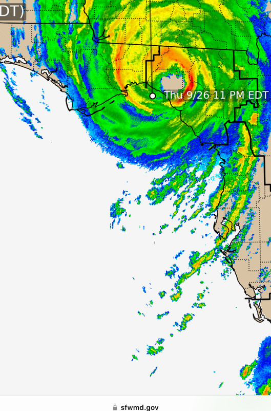
Hurricane2022 wrote:https://imageshack.com/i/poqulyOup
Wow, it's already that far inland? Dang, this thing really is booking it; Georgia better get ready
3 likes
Unless explicitly stated, all information in my posts is based on my own opinions and observations. Tropical storms and hurricanes can be extremely dangerous. Refer to an accredited weather research agency or meteorologist if you need to make serious decisions regarding an approaching storm.

Re: ATL: HELENE - Hurricane - Discussion
Storm surge values:
Clearwater: +7 ft above normal tide
St Pete: +6.5 ft above normal tide
Cedar Key: +8 ft above normal tide
East Port (tampa bay): +7.5 ft above normal tide
All within the last 30 minutes and all still increasing.
Clearwater: +7 ft above normal tide
St Pete: +6.5 ft above normal tide
Cedar Key: +8 ft above normal tide
East Port (tampa bay): +7.5 ft above normal tide
All within the last 30 minutes and all still increasing.
2 likes

Re: ATL: HELENE - Hurricane - Discussion
PavelGaborik10 wrote:TallyTracker wrote:Zarniwoop wrote:I haven’t seen anyplace getting 100 mph winds, let alone 140.
Anyone else? Or is that just over water and subtract when it hits land? Sorry if that’s a dumb question.
You probably won’t see super high winds due to the sparsely populated area where landfall is occurring. The best chance for 100+ mph wind measurements is actually when it gets into Georgia.
To be honest it was slightly underwhelming in the Perry region as well on video compared to similarly strong storms, Reed has been pretty vocal about being underwhelmed with the wind and stating he thinks only a couple gusts were near the 100 MPH range, which is a tad shocking as they got lashed with the eastern eyewall.
Surge on the other hand looks horrific.
Boo hoo? Haha I love Reed but…
8 likes

Re: ATL: HELENE - Hurricane - Discussion
ronjon wrote:Storm surge values:
Clearwater: +7 ft above normal tide
St Pete: +6.5 ft above normal tide
Cedar Key: +8 ft above normal tide
East Port (tampa bay): +7.5 ft above normal tide
All within the last 30 minutes and all still increasing.
Any word of areas near Hernado Beach I have relatives out that way
0 likes
Once I see the REDS and GREENS Converge on a Base Velocity. ... I'm There!!
This is NOT an Official Forecast....Just my Opinion. For official information, please refer to the NHC and NWS products.
HIGHLIGHTS : '13 El Reno Tornado : 2013 Storm Chaser Tour, Joaquin; SC flood event, Matthew '16, Lowcountry Snow storm Jan '18
This is NOT an Official Forecast....Just my Opinion. For official information, please refer to the NHC and NWS products.
HIGHLIGHTS : '13 El Reno Tornado : 2013 Storm Chaser Tour, Joaquin; SC flood event, Matthew '16, Lowcountry Snow storm Jan '18
-
weeniepatrol

- Category 5
- Posts: 1345
- Joined: Sat Aug 22, 2020 5:30 pm
- Location: WA State
-
Hurricane Mike
- Category 2

- Posts: 675
- Joined: Tue Apr 10, 2018 7:44 am
Re: ATL: HELENE - Hurricane - Discussion
Helene Landfall Video Update
https://www.youtube.com/watch?v=YbBmU6v3b7k
https://www.youtube.com/watch?v=YbBmU6v3b7k
0 likes
Re: ATL: HELENE - Hurricane - Discussion
Kohlecane wrote:ronjon wrote:Storm surge values:
Clearwater: +7 ft above normal tide
St Pete: +6.5 ft above normal tide
Cedar Key: +8 ft above normal tide
East Port (tampa bay): +7.5 ft above normal tide
All within the last 30 minutes and all still increasing.
Any word of areas near Hernado Beach I have relatives out that way
https://www.facebook.com/share/p/yPoQcZMPrc7pm6N9/?mibextid=xfxF2i
The reports are not good
1 likes
Personal Forecast Disclaimer:
The posts in this forum are NOT official forecast and should not be used as such. They are just the opinion of the poster and may or may not be backed by sound meteorological data. They are NOT endorsed by any professional institution or storm2k.org. For official information, please refer to the NHC and NWS products.
The posts in this forum are NOT official forecast and should not be used as such. They are just the opinion of the poster and may or may not be backed by sound meteorological data. They are NOT endorsed by any professional institution or storm2k.org. For official information, please refer to the NHC and NWS products.

Re: ATL: HELENE - Hurricane - Discussion
I think it’s just always going to be tough to get dramatic footage of cat 3/4 sustained in the big bend.just no places to safely be at the coast. Perry is 17 miles inland, it’s getting land interaction, wind has to travel a lot of land friction to get there especially with the angle it came in, and got more north eyewall than east.
Louisiana is not dissimilar if I recall when Laura hit lake Charles …the city damage was ugly but you just didn’t see the crazy video they can get from beaches that are less surge prone. That said, storms are unique and location of landfall really impacts what translates down to the ground, so many factors at play. If it underperforms on the extreme wind damage side, I’m sure many folks will be glad. It clearly hasn’t underperformed on surge.
Louisiana is not dissimilar if I recall when Laura hit lake Charles …the city damage was ugly but you just didn’t see the crazy video they can get from beaches that are less surge prone. That said, storms are unique and location of landfall really impacts what translates down to the ground, so many factors at play. If it underperforms on the extreme wind damage side, I’m sure many folks will be glad. It clearly hasn’t underperformed on surge.
7 likes
-
CrazyC83
- Professional-Met

- Posts: 34316
- Joined: Tue Mar 07, 2006 11:57 pm
- Location: Deep South, for the first time!
Re: ATL: HELENE - Hurricane - Discussion
It looks like the eyewall just missed Tallahassee. There are many power outages, but WCTV reporters said the winds were tropical storm force.
3 likes
-
Category5Kaiju
- Category 5
- Posts: 4345
- Joined: Thu Dec 24, 2020 12:45 pm
- Location: Seattle during the summer, Phoenix during the winter
Re: ATL: HELENE - Hurricane - Discussion
Sadly, Helene's death toll is now reported to be 6. This includes two deaths in Georgia from a tornado spawned by the system
5 likes
Unless explicitly stated, all information in my posts is based on my own opinions and observations. Tropical storms and hurricanes can be extremely dangerous. Refer to an accredited weather research agency or meteorologist if you need to make serious decisions regarding an approaching storm.
-
Blown Away

- S2K Supporter

- Posts: 10253
- Joined: Wed May 26, 2004 6:17 am
Re: ATL: HELENE - Hurricane - Discussion
CrazyC83 wrote:It looks like the eyewall just missed Tallahassee. There are many power outages, but WCTV reporters said the winds were tropical storm force.
Tally was a good 40+ miles away so I’m sure it missed the big core winds being on the W side…
2 likes
Hurricane Eye Experience: David 79, Irene 99, Frances 04, Jeanne 04, Wilma 05… Hurricane Brush Experience: Andrew 92, Erin 95, Floyd 99, Matthew 16, Irma 17, Ian 22, Nicole 22…
-
Blown Away
- S2K Supporter
- Posts: 10253
- Joined: Wed May 26, 2004 6:17 am
Re: ATL: HELENE - Hurricane - Discussion
NHC been stubborn with there track today with Helene going east of it all day.
3 likes
Hurricane Eye Experience: David 79, Irene 99, Frances 04, Jeanne 04, Wilma 05… Hurricane Brush Experience: Andrew 92, Erin 95, Floyd 99, Matthew 16, Irma 17, Ian 22, Nicole 22…
-
ElectricStorm

- Category 5
- Posts: 5152
- Age: 25
- Joined: Tue Aug 13, 2019 11:23 pm
- Location: Norman, OK
Re: ATL: HELENE - Hurricane - Discussion
https://x.com/MichaelRLowry/status/1839513795661574492
So I guess this is why the NOAA plane was circling around in the eye for so long earlier today
So I guess this is why the NOAA plane was circling around in the eye for so long earlier today
9 likes
B.S Meteorology, University of Oklahoma '25
Please refer to the NHC, NWS, or SPC for official information.
Please refer to the NHC, NWS, or SPC for official information.
-
Keldeo1997
- Category 2
- Posts: 688
- Joined: Fri Oct 11, 2019 11:35 pm

Re: ATL: HELENE - Hurricane - Discussion
CrazyC83 wrote:Teban54 wrote:It's quite impressive (from a meteorological perspective, not impact) how Helene got to what it is at landfall. There are valid arguments to say it "struggled" at all points of its life: genesis being a bit slower than expected, shear in Western Caribbean and naked LLC (with concerns about John's outflow added to the mix), more interaction with Yucatan than initially thought, and of course, several dry air episodes further south in the Gulf. The fact that "won't be a major" comments were prevalent practically every couple hours is quite telling.
In the end, Helene is both the storm that wished it had 12 hours before landfall, and the storm that actually got 12 hours before landfall. Without this afternoon, it would have been another Francine. With more time to intensify at the insane rates in the last 8 hours, it could have been a Rita.
There's a legitimate chance that Helene may end up being emblematic of the 2024 season as a whole: struggled all along, but still bombed out in the end.
An argument can be made that, if Helene strengthened earlier, it might not have held up as well, since it would have likely started to go into ERC's and started weakening (but expanding even more). It might have reached cat 5 with about 8-12 more hours over water, but not much more than that as other factors would come in.
As bad as the storm surge is I think this scenario would've been worse.
1 likes

Re: ATL: HELENE - Hurricane - Discussion
It's starting to look like the eye is going to pass directly over Valdosta, barring some immediate shift to the north. Helene appears to be tracking a decent amount east of forecast- southeast GA may get more of an impact than initially thought.
1 likes
Who is online
Users browsing this forum: No registered users and 67 guests